Tributary to Owen Creek - 197378 - Appendix
Site Location
PSCIS crossing 197378 is located on Tributary to Owen Creek, on Klate Lake road - approximately 1km upstream from the confluence with Owen Creek, which drains the nearby Owen Lake. Information sourced from the provincial Forest Tenure Road Section Lines spatial layer indicates YLP Woodlands GP Ltd. is a road tenure holder at the crossing location (MoE 2024). YLP Woodlands GP Ltd. is part of the Yinka Dene Economic Development Limited Partnership (YLP) which is the corporate business arm of the Wet’suwet’en First Nation.
Background
PSCIS crossing 197378 on Klate Lake road is located in the Bi Wini house territory, in the house of Keexwinits (House in the Middle of Many) that belongs to the Gitdumden (Bear/Wolf) clan within Wet’suwet’en territory (BC Parks 2010). Felix George 7 First Nation Reserve lands are located on the east side of Owen Lake near the site. A provincial recreation site is also located near the site on the northern tip of Owen Lake
This memo has been updated to reflect ongoing activities related to the restoration of fish passage at the site. The culvert on Klate Lake Road has been earmarked for replacement through the Bii Wenii Kwa Restoration/Recovery Plan which is a collaboration between the Wet’suwet’en Treaty Society, Fisheries and Oceans Canada, BC Ministry of Forests, and Water, Land and Resource Stewardship, Morice Water Monitoring Trust, and Northwest Research and Monitoring. The plan aims to improve watershed health and support both resident and anadromous fish while helping the Wet’suwet’en, and Federal and Provincial governments address habitat risks by enhancing and restoring fish habitat, consolidating existing data, prioritizing restoration work, and providing monitoring recommendations (Morgan and Reese-Hansen 2024).
Klate Lake Road provides access to Nadina Mountain Park. The park was established through a partnership between BC Parks and the Office of the Wet’suwet’en as part of the Morice Land and Resource Management Plan. It is one of seven protected areas resulting from government-to-government agreements. The park protects important cultural, spiritual, and ecological values, including habitat for mountain goats and rare plant communities. Recreational use is non-motorized and includes hiking, hunting, and wildlife viewing. Management priorities focus on conserving ecological integrity and Wet’suwet’en heritage while allowing low-impact education and recreation. Nadina means “standing up alone” in the Wet’suwet’en language (BC Parks 2010, 2025; ILMB 2007).
Klate Lake Road accesses a challenging trail that climbs the northeast slope of Nadina Mountain into the provincial park.
The trail begins at an elevation of 867m and reaches alpine at 1686m, where the route becomes unmarked. From there, hikers
choose their own path to the 2125m summit. A second, longer route to the alpine begins at Nadina Mountain Lodge on Owen
Lake, passing Klate and Base Lakes, but this route is documented as overgrown and difficult due to lack of recent maintenance.
The Berkey-Howe Union Spire is a free-standing granite pillar located at the head of the large cirque on the north-east
exposure of the peak (BC Parks 2025).
Following the recommendations from the 2022 survey (provided in an initial release of this report), crossing 197378 was revisited September 13, 2023 with electrofishing conducted above and below the crossing to gather baseline fisheries data. Results from the sampling have been incorporated into updated versions of this report.
In 2024, an engineering design was commissioned by SERNbc to replace the culvert with a bridge. The design was completed in 2025 by Pacific North Coast Consulting Services. Proposed works include the replacement of the existing 1.0m wide round culvert with a 12m free span bridge. The engineering design and associated background information is included as an attachment to this report and linked here.
At crossing 197378, Tributary to Owen Creek is a third order stream with a watershed area upstream of the crossing of approximately 7.9km2. The elevation of the watershed ranges from a maximum of 2073m to 758m at the crossing (Table 5.23). A total of 3ha of lake and 48ha of wetland is modelled upstream. Upstream of crossing 197378, longnose dace, rainbow trout, mountain whitefish, and dolly varden have previously been recorded (MoE 2020b; Norris 2020). The nearby Owen Lake is approximately 300ha in size. Historical records of fish in this lake include rainbow trout, burbot, coho, sucker, dolly varden, lake trout, and whitefish.
my_caption <- "Map showing PSCIS crossing 197378 on Klate Lake / Nadina Mountain Road."
knitr::include_graphics("data/inputs_raw/klate_lake_road_trib_to_owen_197378.jpeg")
Figure 5.36: Map showing PSCIS crossing 197378 on Klate Lake / Nadina Mountain Road.
fpr::fpr_table_wshd_sum(site_id = my_site) %>%
  fpr::fpr_kable(caption_text = paste0('Summary of derived upstream watershed statistics for PSCIS crossing ', my_site, '.'),
           footnote_text = 'Elev P60 = Elevation at which 60% of the watershed area is above',
scroll = F)| Site | Area Km | Elev Site | Elev Min | Elev Max | Elev Median | Elev P60 | Aspect |
|---|---|---|---|---|---|---|---|
| 197378 | 7.9 | 758 | 743 | 2073 | 920 | 885 | ENE |
| * Elev P60 = Elevation at which 60% of the watershed area is above |
A summary of habitat modelling outputs is presented in Table 5.24. A map of the watershed is provided in map attachment 093L.104.
| Habitat | Potential | Remediation Gain | Remediation Gain (%) |
|---|---|---|---|
| ST Network (km) | 12.3 | 12.3 | 100 |
| ST Lake Reservoir (ha) | 2.8 | 2.8 | 100 |
| ST Wetland (ha) | 48.3 | 48.3 | 100 |
| ST Slopeclass03 Waterbodies (km) | 1.8 | 0.0 | 0 |
| ST Slopeclass03 (km) | 0.3 | 0.3 | 100 |
| ST Slopeclass05 (km) | 0.9 | 0.9 | 100 |
| ST Slopeclass08 (km) | 7.9 | 7.9 | 100 |
| ST Spawning (km) | 0.0 | 0.0 | – |
| ST Rearing (km) | 0.9 | 0.9 | 100 |
| CH Spawning (km) | 0.0 | 0.0 | – |
| CH Rearing (km) | 0.0 | 0.0 | – |
| CO Spawning (km) | 0.6 | 0.6 | 100 |
| CO Rearing (km) | 0.6 | 0.6 | 100 |
| CO Rearing (ha) | – | 0.0 | – |
| SK Spawning (km) | 0.0 | 0.0 | – |
| SK Rearing (km) | 0.0 | 0.0 | – |
| SK Rearing (ha) | – | 0.0 | – |
| All Spawning (km) | 0.6 | 0.6 | 100 |
| All Rearing (km) | 0.9 | 0.9 | 100 |
| All Spawning Rearing (km) | 0.9 | 0.9 | 100 |
| * Model data is preliminary and subject to adjustments. |
Stream Characteristics at Crossing
At the time of the survey, PSCIS crossing 197378 was un-embedded, non-backwatered and ranked as a barrier to upstream fish passage according to the provincial protocol (MoE 2011b) (Table 5.25). The pipe was in very rough condition and had collapsed and separated in half which effected water flow into the barrel. The water temperature was 11\(^\circ\)C, pH was 7.6 and conductivity was 84uS/cm.
| Location and Stream Data |
|
Crossing Characteristics | – |
|---|---|---|---|
| Date | 2021-09-07 | Crossing Sub Type | Round Culvert |
| PSCIS ID | 197378 | Diameter (m) | 1 |
| External ID | – | Length (m) | 15 |
| Crew | AI KP TP VJ | Embedded | No |
| UTM Zone | 9 | Depth Embedded (m) | – |
| Easting | 645084.9 | Resemble Channel | No |
| Northing | 5998822 | Backwatered | No |
| Stream | Tributary to Owen Creek | Percent Backwatered | – |
| Road | Klate Lake | Fill Depth (m) | 2.5 |
| Road Tenure | West Fraser R04075 | Outlet Drop (m) | 0.1 |
| Channel Width (m) | 2.4 | Outlet Pool Depth (m) | 0.6 |
| Stream Slope (%) | 3 | Inlet Drop | Yes |
| Beaver Activity | Yes | Slope (%) | 1 |
| Habitat Value | Medium | Valley Fill | Deep Fill |
| Final score | 24 | Barrier Result | Barrier |
| Fix type | Replace with New Open Bottom Structure | Fix Span / Diameter | 10 |
Photos: From top left clockwise: Road/Site Card, Barrel, Outlet, Downstream, Upstream, Inlet.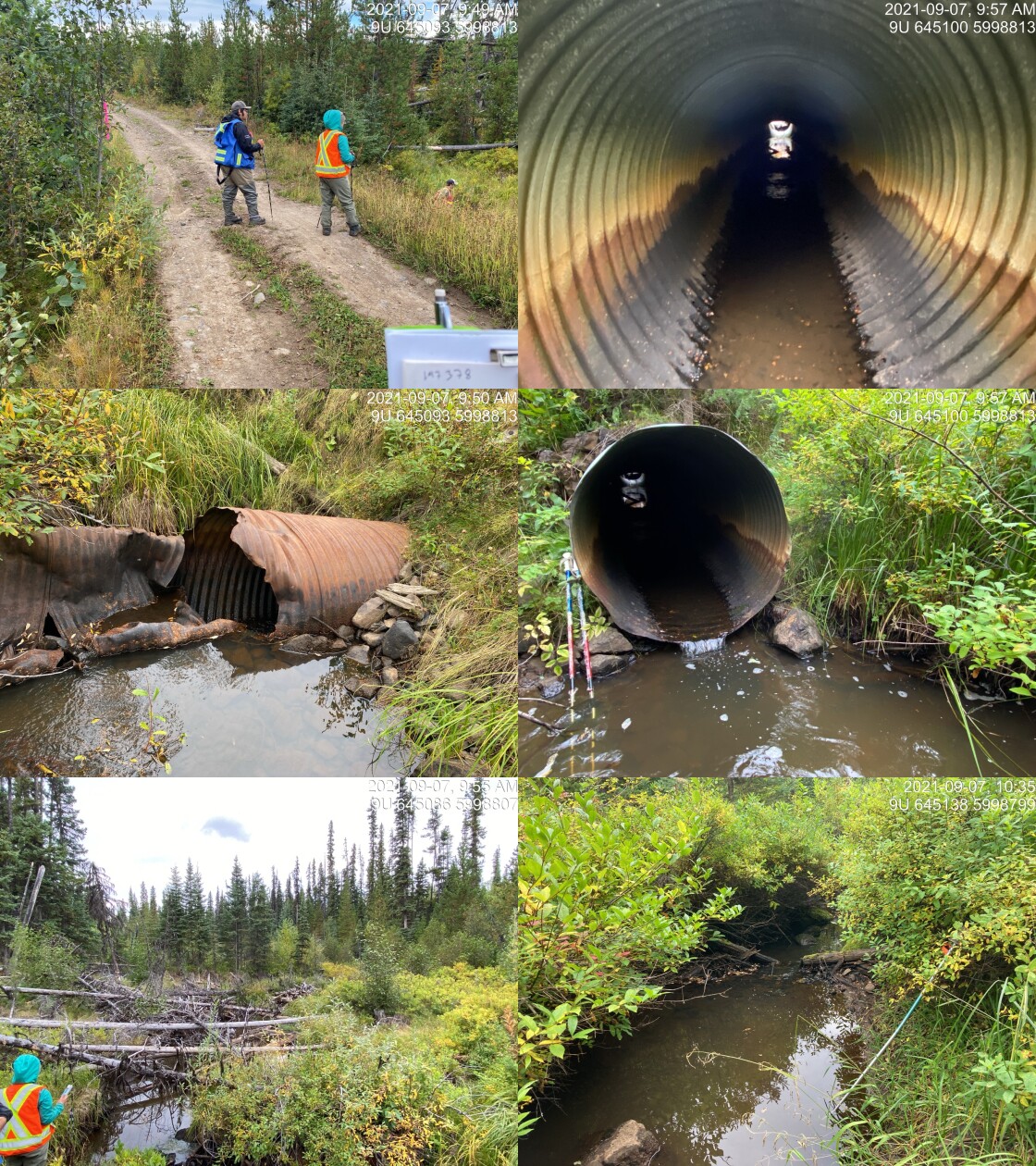
|
|||
| Comments: Damage to pipe. Wetland type area. 9:49 |
Stream Characteristics Downstream
The stream was surveyed downstream from crossing 197378 for 450m (Figure 5.38). Total cover amount was rated as abundant with overhanging vegetation dominant. Cover was also present as small woody debris and undercut banks.The dominant substrate was gravels with fines sub-dominant.The average channel width was 2.4m, the average wetted width was 1.9m, and the average gradient was 2.5%. There was a high percentage of crown closure, with riparian shrubs but a thin, coniferous forest further upland. There was an numerous pockets of gravels suitable for rainbow and dolly varden spawning. The stream appeared to have stable flows with no notable erosion. Overall, the habitat was rated as medium value for salmonid rearing and spawning.
Stream Characteristics Upstream
The stream was surveyed upstream from crossing 197378 for 665m (Figure 5.39). The dominant substrate was gravels with fines sub-dominant.Total cover amount was rated as abundant with undercut banks dominant. Cover was also present as small woody debris, large woody debris, overhanging vegetation, and instream vegetation.The average channel width was 1.8m, the average wetted width was 1.5m, and the average gradient was 3%. This was a small stream containing multiple beaver influenced wetland areas with dams. The stream was comprised of two seperate channels mapped as converging approximatley 100m upstream of the crossing. The dominant channel was the stream mapped as furthest north in the freshwater atlas. It was surveyed in an upstream direction to the location of a beaver influenced wetland. Several pockets of gravel suitable for resident rainbow and dolly varden spawning were present. Surveyors noted “nice runs” and good flow volume. The habitat was rated as medium value with moderate rearing potential. Surveyors visited the southern channel at a point approximately 350m upstream of the FSR but the stream channel at this location was very small with fine sediment substrate.
Fish Sampling
As noted above - following recommendations from the 2022 survey, crossing 197378 was revisited on September 13, 2023 and electrofishing was conducted upstream and downstream of Klate Lake. Results are summarised in Tables 5.27 - 5.28 and Figure 5.37. A total of 7 rainbow trout were captured upstream, and 11 rainbow trout were captured downstream (Figures 5.40 - 5.41). All fish captured with a fork length greater than 60mm were tagged with Passive Integrated Transponders (PIT tags) with data stored here.
Structure Remediation and Cost Estimate
Should restoration/maintenance activities proceed, replacement of PSCIS crossing 197378 with a bridge (10m span) is recommended. The cost of the work is estimated at $300,000 for a cost benefit of 1.9 linear m/$1000 and 3.4 m2/$1000.
Conclusion
There was 0.6km of habitat modelled upstream of crossing 197378 modelled as highing high intrinsic value for steelhead based on gradient and width. Areas surveyed were rated as medium value for salmonid rearing with large areas of wetland present. The culvert pipe was noted as in very poor condition with the structure near complete collapse. Although fish sampling within small areas upstream and downstream of the crossing in 2023 resulted in the capture of rainbow trout only, other species such as coho utilizing the mainstem of Owen Creek may have accessed this area historically.
The Office of Wet’suwet’en has initiated watershed level Nation led recovery/restoration planning for the greater Bii Wenii Kwa (Owen Creek) watershed which includes restoration of this site as a project priority consideration. As the Yinka Dene Economic Development Limited Partnership is noted as a road tenure holder at the location of the site, there could be opportunities for collaboration between the two groups related to restoration or removal of the crossing. Crossing 197378 was ranked as a moderate priority for proceeding to design for replacement. In 2024, an engineering design was commissioned by SERNbc to replace the culvert with a bridge. The design was completed in 2025 by Pacific North Coast Consulting Services. Proposed works include the replacement of the existing 1.0m wide round culvert with a 12m free span bridge.
tab_hab_summary %>%
  filter(Site  == my_site) %>%
  # select(-Site) %>%
  fpr::fpr_kable(caption_text = paste0('Summary of habitat details for PSCIS crossing ', my_site, '.'),
scroll = F) | Site | Location | Length Surveyed (m) | Channel Width (m) | Wetted Width (m) | Pool Depth (m) | Gradient (%) | Total Cover | Habitat Value |
|---|---|---|---|---|---|---|---|---|
| 197378 | Downstream | 450 | 2.4 | 1.9 | 0.2 | 2.5 | abundant | medium |
| 197378 | Upstream | 665 | 1.8 | 1.5 | – | 3.0 | abundant | medium |
| site | passes | ef_length_m | ef_width_m | area_m2 | enclosure |
|---|---|---|---|---|---|
| 197378_ds_ef1 | 1 | 7 | 3.0 | 21 | Open |
| 197378_us_ef1 | 1 | 10 | 2.2 | 22 | Open |
| local_name | species_code | life_stage | catch | density_100m2 | nfc_pass |
|---|---|---|---|---|---|
| 197378_ds_ef1 | RB | fry | 5 | 23.8 | FALSE |
| 197378_ds_ef1 | RB | parr | 6 | 28.6 | FALSE |
| 197378_us_ef1 | RB | fry | 6 | 27.3 | FALSE |
| 197378_us_ef1 | RB | parr | 1 | 4.5 | FALSE |
|
* nfc_pass FALSE means fish were captured in final pass indicating more fish of this species/lifestage may have remained in site. Mark-recaptured required to reduce uncertainties. |
my_caption <- paste0('Densites of fish (fish/100m2) captured upstream and downstream of PSCIS crossing ', my_site, ' in 2023.')

fpr_plot_fish_box(dat = fish_abund_2023, sit = my_site) 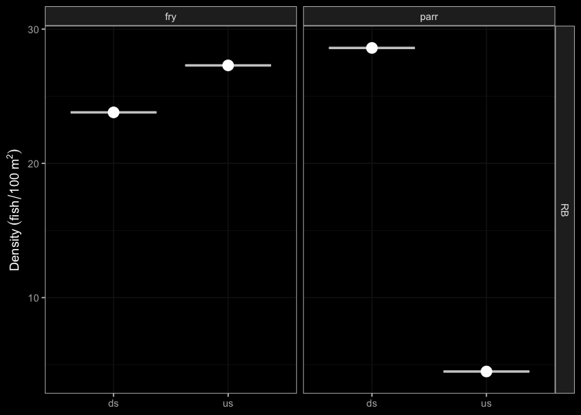
Figure 5.37: Densites of fish (fish/100m2) captured upstream and downstream of PSCIS crossing 197378 in 2023.
my_photo1 = fpr::fpr_photo_pull_by_str(str_to_pull = '_d2_')

my_caption1 = paste0('Typical habitat downstream of PSCIS crossing ', my_site, '.')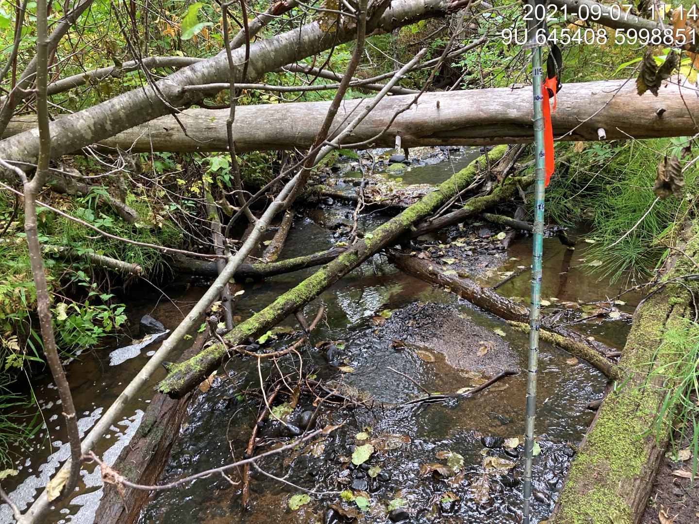
Figure 5.38: Typical habitat downstream of PSCIS crossing 197378.
my_photo2 = fpr::fpr_photo_pull_by_str(str_to_pull = '_u1_')

my_caption2 = paste0('Typical habitat upstream of PSCIS crossing ', my_site, '.')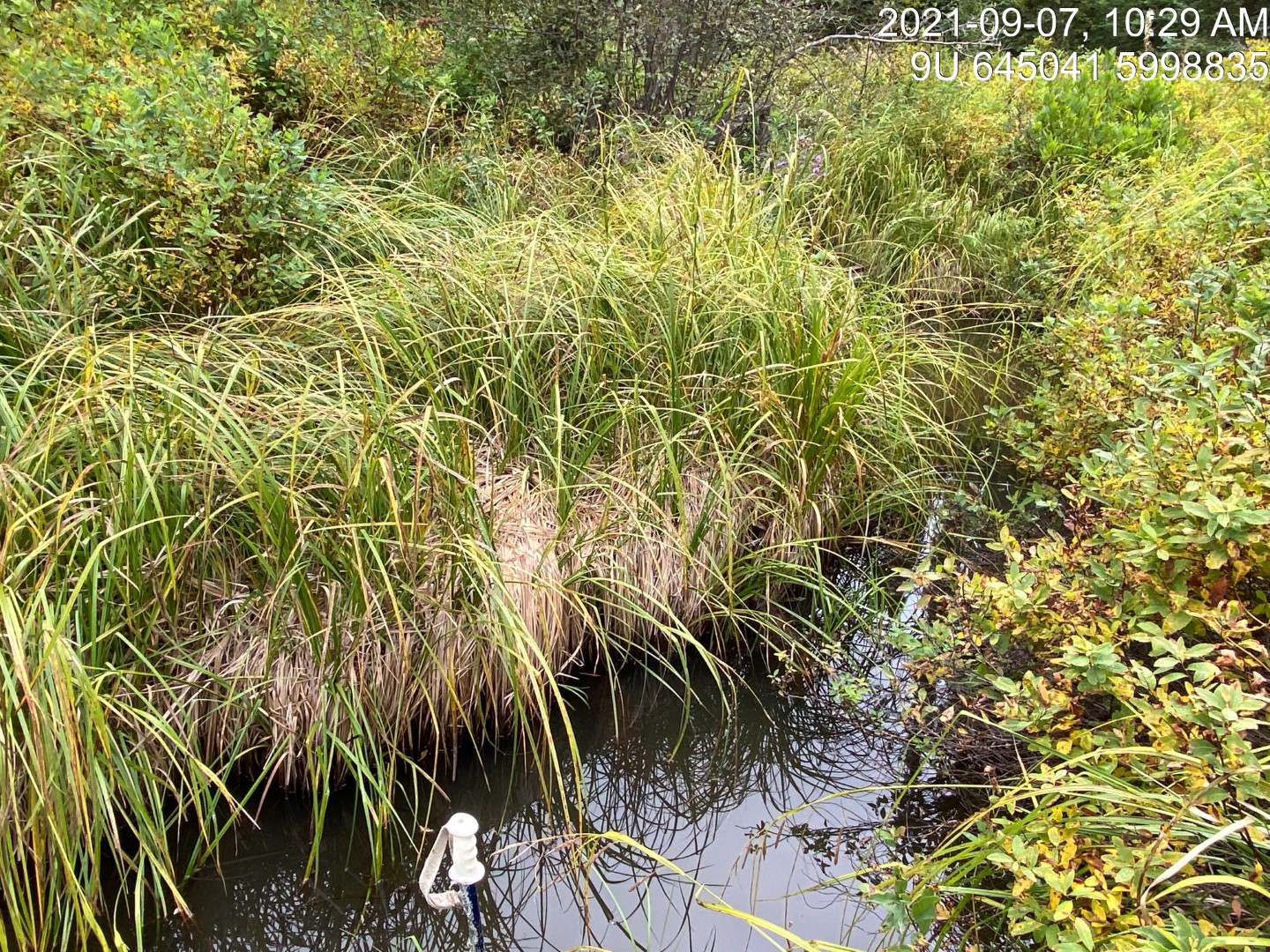
Figure 5.39: Typical habitat upstream of PSCIS crossing 197378.
my_caption <- paste0('Left: ', my_caption1, ' Right: ', my_caption2)

knitr::include_graphics(my_photo1)
knitr::include_graphics("fig/pixel.png")
knitr::include_graphics(my_photo2)
my_photo1 = fpr::fpr_photo_pull_by_str(dir_photos = "data/2023/photos/", str_to_pull = 'fish1')
my_caption1 = paste0('Rainbow trout captured downstream of PSCIS crossing ', my_site, ' in 2023.')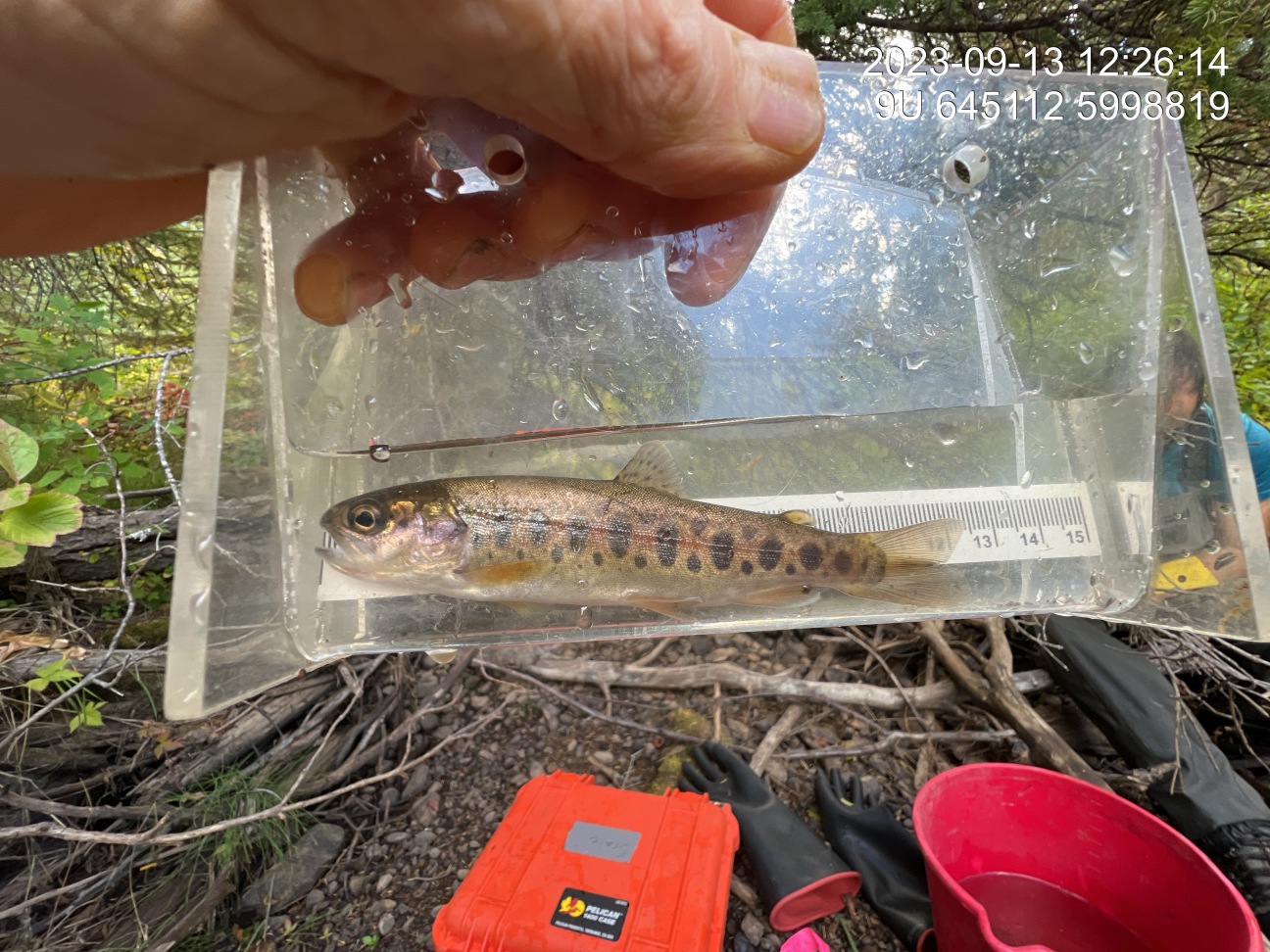
Figure 5.40: Rainbow trout captured downstream of PSCIS crossing 197378 in 2023.
my_photo2 = fpr::fpr_photo_pull_by_str(dir_photos = "data/2023/photos/", str_to_pull = 'fish2')

my_caption2 = paste0('Rainbow trout captured upstream of PSCIS crossing ', my_site, ' in 2023.')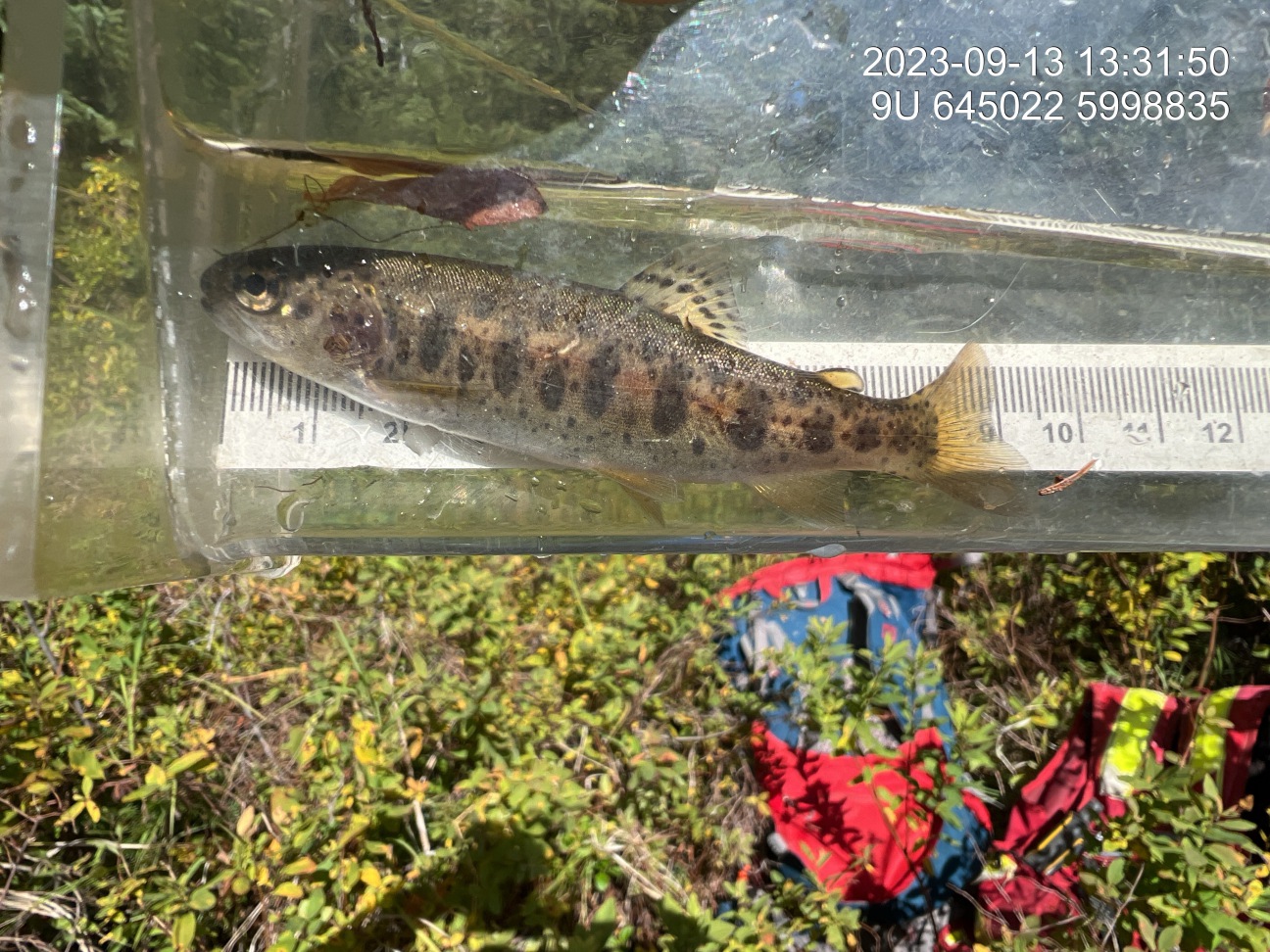
Figure 5.41: Rainbow trout captured upstream of PSCIS crossing 197378 in 2023.
my_caption <- paste0('Left: ', my_caption1, ' Right: ', my_caption2)

knitr::include_graphics(my_photo1)
knitr::include_graphics("fig/pixel.png")
knitr::include_graphics(my_photo2)