Gramophone Creek - 58067 - Appendix
Site Location
PSCIS crossing 58067 is located on Gramophone Creek approximately 9km south of the community of Witset, BC on Telkwa High Rd. Crossing 58067 was located 2.6km upstream from the confluence with the Bulkley River and is the responsibility of the Ministry of Transportation and Infrastructure.
Background
At crossing 58067, Gramophone Creek is a fourth order stream with a watershed area upstream of the crossing of approximately 33.3km2. The elevation of the watershed ranges from a maximum of 1480m to 459m at the crossing (Table 5.33). Upstream of Telkwa High Rd, rainbow trout and steelhead have previously been recorded (MoE 2020b; Norris 2020). Of note, FISS records indicate that a steelhead spawning location is located approximatley 60m upstream of Telkwa High Rd with the source reference noted as a personal communication with M. O’Neill from the Toboggan Creek Hatchery.
The stream was initially assessed on September 1st and 2nd, 2022, with much of this memo drafted then. However, as no coho were captured during extensive electrofishing in 2022, the site was revisited on September 24,2023 to scope for barriers downstream of Telkwa High Rd and the confluence with the Bulkley River. Results from that assessment and subsequent dip netting conducted are included in this report.
fpr::fpr_table_wshd_sum(site_id = my_site) %>%
  select(-'Elev Min') %>%
  fpr::fpr_kable(caption_text = paste0('Summary of derived upstream watershed statistics for PSCIS crossing ', my_site, '.'),
           footnote_text = 'Elev P60 = Elevation at which 60% of the watershed area is above',
scroll = F)| Site | Area Km | Elev Site | Elev Max | Elev Median | Elev P60 | Aspect |
|---|---|---|---|---|---|---|
| 58067 | 33.3 | 459 | 1480 | 1043 | 951 | WSW |
| * Elev P60 = Elevation at which 60% of the watershed area is above |
The Gramophone Creek watershed is designated as a Fisheries Sensitive Watershed under British Columbia’s Forest and Range Practices Act Government Actions Regulation, and the Oil and Gas Activities Act Environmental Management and Protection Regulation. Fisheries Sensitive Watersheds have significant fish values and are sensitive to changes in habitat (M. Porter et al. 2015).
Sterling Wood Group Inc. (1997) report that the Trout Creek/Moricetown watershed project was an integrated restoration plan designed for 14 watersheds found on either side of the Bulkley River with Gramophone Creek included as one of the watersheds. A level I sediment source assessment was conducted in the watershed providing a risk assessment of sedimentation by classifying road placement as on low, moderate, or high-risk terrain. Additionally, the lvel of consequence that sedimentation could have on fisheries values was also assessed. Gramophone Creek scored lower than average overall with study blocks present that required level II assessment.
In a study conducted by M. Porter et al. (2015), the Gramophone Creek stream network was analysed using GIS methods to assess the risk status related to fish habitat impact. Risk status was determined by measuring nine habitat indicators including: road density, road density above the H60 line (the elevation above which 60% of the watershed area lies), road density less than 100m from a stream, stream crossing density, proportion of stream logged, proportion of fish-bearing stream logged, density of stream banks logged on slopes greater than 60%, peak flow index, and road density on unstable slopes. Measured values were compared to a baseline to classify risk as low, moderate, or high. Of the 71 watersheds included in the analysis, Gramophone Creek was notable for having all nine indicators rated as high risk.
PSCIS stream crossing 58067 was ranked as a high priority for follow up by the Canadian Wildlife Federation because of significant amounts of habitat modelled upstream of the crossing. Upon review of an assessment done on this crossing in 2012 by Gollner, Cain, and Russell (2013), Irvine (2018) also ranked it as a high priority for follow up due to its high habitat value. A summary of habitat modelling outputs is presented in Table 5.34. A map of the watershed is provided in map attachment 093L.122.
| Habitat | Potential | Remediation Gain | Remediation Gain (%) |
|---|---|---|---|
| ST Network (km) | 23.9 | 14.0 | 59 |
| ST Lake Reservoir (ha) | 0.1 | 0.0 | 0 |
| ST Wetland (ha) | 3.3 | 0.0 | 0 |
| ST Slopeclass03 Waterbodies (km) | 0.3 | 0.0 | 0 |
| ST Slopeclass03 (km) | 1.9 | 1.4 | 74 |
| ST Slopeclass05 (km) | 3.3 | 3.2 | 97 |
| ST Slopeclass08 (km) | 5.1 | 3.0 | 59 |
| ST Spawning (km) | 0.0 | 0.0 | – |
| ST Rearing (km) | 3.4 | 3.4 | 100 |
| CH Spawning (km) | 0.0 | 0.0 | – |
| CH Rearing (km) | 3.4 | 3.4 | 100 |
| CO Spawning (km) | 3.4 | 3.4 | 100 |
| CO Rearing (km) | 3.4 | 3.4 | 100 |
| CO Rearing (ha) | – | 0.0 | – |
| SK Spawning (km) | 0.0 | 0.0 | – |
| SK Rearing (km) | 0.0 | 0.0 | – |
| SK Rearing (ha) | – | 0.0 | – |
| All Spawning (km) | 5.4 | 5.0 | 93 |
| All Rearing (km) | 3.4 | 3.4 | 100 |
| All Spawning Rearing (km) | 5.4 | 5.0 | 93 |
| * Model data is preliminary and subject to adjustments. |
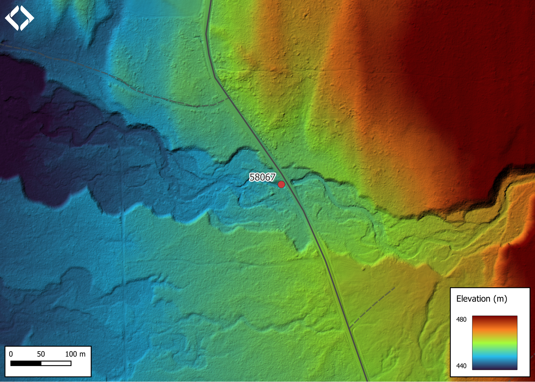
Figure 5.36: Lidar generated digital elevation model of Gramophone Creek at Telkwa High Rd (data collected in 2019, taken from BC Open LiDAR data portal).
5.4 Climate Change Risk Assessment
Preliminary climate change risk assessment data is presented in Tables 5.35 - 5.36.
| Condition and Climate Risk | Rank | Priority | Rank |
|---|---|---|---|
| Erosion (scale 1 low - 5 high) | 4 | Traffic Volume 1 (low) 5 (medium) 10 (high) | 6 |
| Embankment fill issues 1 (low) 2 (medium) 3 (high) | 2 | Community Access - Scale - 1 (high - multiple road access) 5 (medium - some road access) 10 (low - one road access) | 5 |
| Blockage Issues 1 (0-30%) 2 (>30-75%) 3 (>75%) | 1 | Cost (scale: 1 high - 10 low) | 8 |
| Condition Rank = embankment + blockage + erosion | 7 | Constructibility (scale: 1 difficult -10 easy) | 9 |
| Likelihood Flood Event Affecting Culvert (scale 1 low - 5 high) | 2 | Environmental Impacts (scale: 1 high -10 low) | 8 |
| Consequence Flood Event Affecting Culvert (scale 1 low - 5 high) | 1 | Fish Bearing 10 (Yes) 0 (No) - see maps for fish points | 10 |
| Climate Change Flood Risk (likelihood x consequence) 1-6 (low) 6-12 (medium) 10-25 (high) | 2 | Priority Rank = traffic volume + community access + cost + constructability + fish bearing + environmental impacts | 46 |
| Vulnerability Rank = Condition Rank + Climate Rank | 9 | Overall Rank = Vulnerability Rank + Priority Rank | 55 |
| Category | Comments |
|---|---|
| Condition | Erosion is present on upstream side of roadway. Significant embankment issues on downstream end at the outlet pool. Downstream end of main flow pipe is bent significantly downwards. There is corrosion in the overflow pipe causing the water to flow underneath the pipe. Holes in the overflow pipe are located approximately 1.8 m from the outlet. There are low overhead power lines at site. |
| Climate | Large stream but a low risk of a flood event having serious implications due to lack of infrastructure downstream and wetlands that would buffer sediment inputs. |
| Priority | Site on lower traffic gravel road. Detour available. Easy constructibility and low cost makes this a good candidate for replacement. |
Stream Characteristics at Crossing
At the time of the survey in 2022, PSCIS crossing 58067 was un-embedded, non-backwatered, had an outlet drop of 0.49m and ranked as a barrier to upstream fish passage according to the provincial protocol (MoE 2011b) (Table 5.37). The crossing consisted of two pipes, with a very big outlet pool indicating the crossing was undersized. The pipes were noted as in poor condition due to corrosion and the road prism at the site had indications of significant erosion adjacent to the crossing. Water temperature was 12\(^\circ\)C, pH was 8.2 and conductivity was 93uS/cm.
| Location and Stream Data |
|
Crossing Characteristics | – |
|---|---|---|---|
| Date | 2022-09-01 | Crossing Sub Type | Oval Culvert |
| PSCIS ID | 58067 | Diameter (m) | 2.2 |
| External ID | – | Length (m) | 16 |
| Crew | AI CM JO | Embedded | No |
| UTM Zone | 9 | Depth Embedded (m) | – |
| Easting | 609735.8 | Resemble Channel | No |
| Northing | 6092880 | Backwatered | No |
| Stream | Gramophone Creek | Percent Backwatered | – |
| Road | Telkwa High Rd | Fill Depth (m) | 1.8 |
| Road Tenure | MoTi | Outlet Drop (m) | 0.49 |
| Channel Width (m) | 6.6 | Outlet Pool Depth (m) | 1.46 |
| Stream Slope (%) | 4 | Inlet Drop | Yes |
| Beaver Activity | No | Slope (%) | 0.3 |
| Habitat Value | High | Valley Fill | Deep Fill |
| Final score | 29 | Barrier Result | Barrier |
| Fix type | Replace with New Open Bottom Structure | Fix Span / Diameter | 15 |
Photos: From top left clockwise: Road/Site Card, Barrel, Outlet, Downstream, Upstream, Inlet.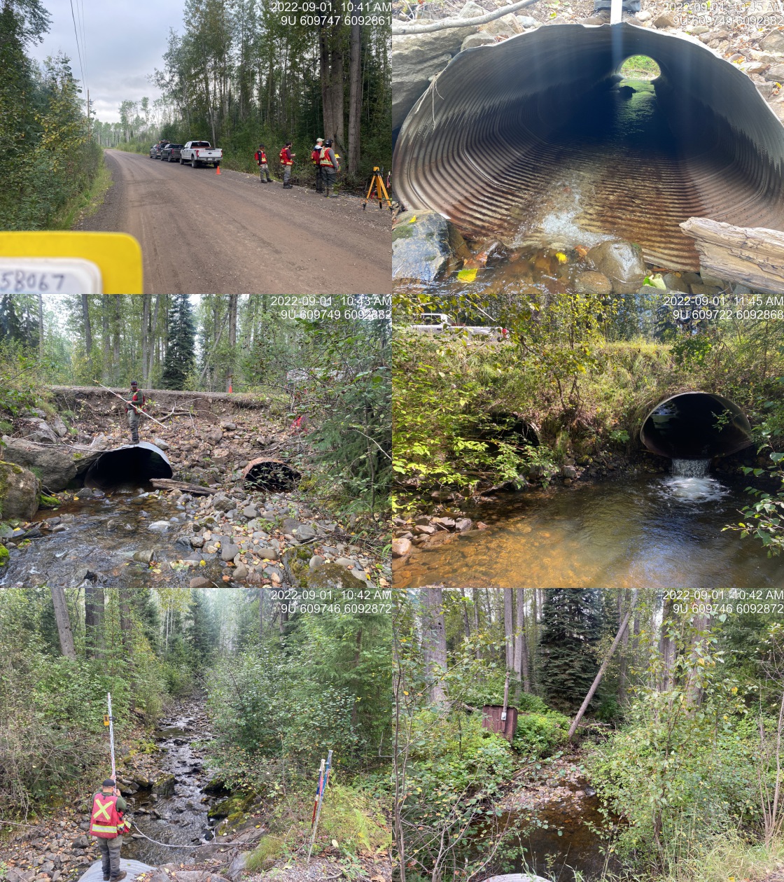
|
|||
| Comments: Gradient of culvert shot with laser level. Inside of pipe is bent downward at the outlet. Upstream side of the road is eroding. Enormous outlet pool indicates culvert is undersized. Water flowing under overflow. Just outside of Witset community. Seems like a really good candidate for replacement. 10:26 |
Stream Characteristics Downstream
The stream was surveyed downstream from crossing 58067 for 300m in 2022 (Figures 5.38 - 5.39). <<<<<<< Updated upstream Total cover amount was rated as moderate with undercut banks dominant. Cover was also present as small woody debris, boulders, deep pools, and overhanging vegetation.The dominant substrate was cobbles with boulders sub-dominant.The average channel width was 5.1m, the average wetted width was 3m, and the average gradient was 3%. There were abundant undercut banks available for cover. Some patches of gravel ======= Total cover amount was rated as moderate with undercut banks dominant. Cover was also present as small woody debris, boulders, deep pools, and overhanging vegetation.The average channel width was 5.1m, the average wetted width was 3m, and the average gradient was 3%.The dominant substrate was cobbles with boulders sub-dominant. There were abundant undercut banks available for cover. Some patches of gravel >>>>>>> Stashed changes were present suitable for rainbow, steelhead and coho spawning. Occasional deep pools were present suitable for juvenile rearing and overwintering. Riparian vegetation was mixed deciduous and conifer old growth forest. The habitat was rated as high value for salmonid rearing and spawning.
In 2023, the entire 2.6km between Telkwa High Rd and the confluence with the Bulkley River was surveyed with the stream delineated into two distinct sections. The first was the ~800m long section from Telkwa High Rd to the confluence with Wiggs Creek. The second was 1.8km long and spanned from the Wiggs Creek confluence to the Bulkley River.
The first section (from the road to Wiggs Creek) was noted as containing low water levels with sections of the stream completely de-watered (particularly the first 300m below Telkwa High Rd). There were isolated pools to 0.6m deep scattered approximately 30 - 50m apart throughout the area surveyed and abundant algae present within areas of slow and stagnant water. Failing banks were encountered with barbwire fence falling into the stream channel at multiple locations along with sections of channel where extensive cattle trampling and manure deposition was evident. Surveyors also noted occasional pockets of gravel present suitable for resident and anadromous salmonid spawning. Overall, habitat was rated as high value.
In the second section surveyed - between the confluence of Wiggs Creek and the Bulkley River - at a location approximately 600m upstream from the confluence with the Bulkley, crews observed a 40m long canyon containing two rock outcrops located at the downstream and upstream ends of a 25m long rock chute (~25% gradient). The rock outcrops at both the bottom and the top of the chute were estimated at 1.7m high (Figures 5.44 - 5.45).. The approximate UTM coordinates of the bottom end of the chute was noted as 9U.607989.6093242. Additionally, at the time of assessment, the ~300m upstream of the Bulkley River confluence the stream was de-watered almost entirely. Overall, the habitat was rated as high value.
Stream Characteristics Upstream
The stream was surveyed upstream from crossing 58067 for 600m (Figures 5.40 - 5.43). The dominant substrate was cobbles with gravels sub-dominant.The average channel width was 5.7m, the average wetted width was 4m, and the average gradient was 3%.Total cover amount was rated as moderate with boulders dominant. Cover was also present as small woody debris and undercut banks. There is a small beaver dam ~500m upstream from the crossing. The stream is wide throughout with abundant cover and some areas with gravels suitable for spawning. There is approximately 50m of open residential area on the right bank. The habitat was rated as high value as an important migration corridor containing suitable spawning habitat and having moderate rearing potential.
Fish Sampling
Electrofishing was conducted at 12 sites in 2022 with results summarised in Tables 5.39 - 5.40 and Figure 5.37.
During the 2023 site visit, dip netting within the canyon, in the large pool immediately below the rock chute and rock outcrops was conducted. Six coho were captured ranging in size from 65 - 90mm (Figures 5.46 - 5.47).
Structure Remediation and Cost Estimate
Should restoration/maintenance activities proceed, replacement of PSCIS crossing 58067 with a bridge (15m span) is recommended. The cost of the work is estimated at $1,150,000 for a cost benefit of 2982.6 linear m/$1000 and 9842.6 m2/$1000.
Conclusion
Electrofishing in 2022 demonstrated that Gramophone Creek supports a healthy population of rainbow trout. However, the migration of anadromous fish such as coho and steelhead — up to the chute, canyon, and rock outcrops located ~600 meters upstream of the confluence with the Bulkley River depends on both migration timing and stream water levels. Water conditions, influenced by timing and quantity of precipitation are important, as evidenced by the dewatering observed in the first 300 meters of stream in late September 2023. Historical data, including the documented personal communication of a steelhead spawning location upstream of Telkwa High Rd, indicates that steelhead are able to overcome the obstacles to fish passage located at the canyon during higher flow periods. In contrast, no coho have ever been documented as captured upstream of the canyon features and their confirmed presence downstream of the canyon in 2023 suggests that these obstacles have consistently hindered their migration. Interestingly, the varied fork lengths of coho parr captured below the chute (65 - 90mm) in 2023 indicate likely differing spawning times in 2022. This varied spawning timing, the relatively low height of the rock outcrops (~1.7 meters) and the gentle gradient of the 25-meter long chute (~25%) offer hope that high flow events coinciding with any period of steelhead and coho migration timing may facilitate upstream passage to habitat upstream of these obstacles for both anadromous species.
There was 3.4km of habitat modelled upstream of crossing 58067 with areas surveyed rated as high value for salmonid rearing and spawning. Gramophone Creek is a large system with habitat suitable for numerous species including coho salmon and steelhead provided they can access above the canyon features at ~600m upstream from the confluence with the Bulkley River. Nevertheless, the large outlet drop on the culverts, their poor condition and the crossing’s location adjacent to the community of Witset, BC provides significant justification for proceeding with replacement of the structures with with significant hope for community involvement in the project. Also, as Telkwa High Rd is a non-paved road with a crossing location that can be accessed from either side, the costs of the work are low when compared to paved road and highway options. Crossing 58067 was ranked as a high priority for proceeding to design for replacement.
tab_hab_summary %>%
  filter(Site  == my_site) %>%
  fpr::fpr_kable(caption_text = paste0('Summary of habitat details for PSCIS crossing ', my_site, '.'),
scroll = F) | Site | Location | Length Surveyed (m) | Channel Width (m) | Wetted Width (m) | Pool Depth (m) | Gradient (%) | Total Cover | Habitat Value |
|---|---|---|---|---|---|---|---|---|
| 58067 | Downstream | 300 | 5.1 | 3 | 0.4 | 3 | moderate | high |
| 58067 | Upstream | 600 | 5.7 | 4 | 0.3 | 3 | moderate | high |
| site | passes | ef_length_m | ef_width_m | area_m2 | enclosure |
|---|---|---|---|---|---|
| 58067_ds_ef1 | 1 | 15.9 | 3.3 | 52.5 | open |
| 58067_ds_ef2 | 1 | 24.0 | 3.6 | 86.4 | open |
| 58067_ds_ef3 | 1 | 25.2 | 3.5 | 88.2 | open |
| 58067_ds_ef4 | 1 | 32.2 | 3.4 | 109.5 | open |
| 58067_ds_ef5 | 1 | 13.0 | 2.6 | 33.8 | open |
| 58067_ds_ef6 | 1 | 7.7 | 5.6 | 43.1 | open |
| 58067_us_ef1 | 1 | 8.6 | 3.4 | 29.2 | open |
| 58067_us_ef2 | 1 | 19.8 | 2.8 | 55.4 | open |
| 58067_us_ef3 | 1 | 25.2 | 3.5 | 88.2 | open |
| 58067_us_ef4 | 1 | 32.2 | 2.8 | 90.2 | open |
| 58067_us_ef5 | 1 | 13.0 | 3.1 | 40.3 | open |
| 58067_us_ef6 | 1 | 6.0 | 4.0 | 24.0 | open |
| local_name | species_code | life_stage | catch | density_100m2 | nfc_pass |
|---|---|---|---|---|---|
| 58067_ds_ef1 | RB | fry | 1 | 1.9 | FALSE |
| 58067_ds_ef1 | RB | parr | 2 | 3.8 | FALSE |
| 58067_ds_ef1 | RB | juvenile | 2 | 3.8 | FALSE |
| 58067_ds_ef1 | RB | adult | 2 | 3.8 | FALSE |
| 58067_ds_ef2 | RB | parr | 3 | 3.5 | FALSE |
| 58067_ds_ef2 | RB | juvenile | 1 | 1.2 | FALSE |
| 58067_ds_ef2 | RB | adult | 2 | 2.3 | FALSE |
| 58067_ds_ef3 | RB | fry | 1 | 1.1 | FALSE |
| 58067_ds_ef3 | RB | parr | 1 | 1.1 | FALSE |
| 58067_ds_ef3 | RB | juvenile | 2 | 2.3 | FALSE |
| 58067_ds_ef3 | RB | adult | 1 | 1.1 | FALSE |
| 58067_ds_ef4 | RB | fry | 1 | 0.9 | FALSE |
| 58067_ds_ef4 | RB | parr | 1 | 0.9 | FALSE |
| 58067_ds_ef4 | RB | juvenile | 1 | 0.9 | FALSE |
| 58067_ds_ef4 | RB | adult | 1 | 0.9 | FALSE |
| 58067_ds_ef5 | RB | fry | 3 | 8.9 | FALSE |
| 58067_ds_ef5 | RB | parr | 1 | 3.0 | FALSE |
| 58067_ds_ef5 | RB | juvenile | 1 | 3.0 | FALSE |
| 58067_ds_ef6 | RB | fry | 2 | 4.6 | FALSE |
| 58067_ds_ef6 | RB | juvenile | 2 | 4.6 | FALSE |
| 58067_us_ef1 | RB | parr | 1 | 3.4 | FALSE |
| 58067_us_ef1 | RB | juvenile | 1 | 3.4 | FALSE |
| 58067_us_ef2 | RB | parr | 7 | 12.6 | FALSE |
| 58067_us_ef2 | RB | adult | 1 | 1.8 | FALSE |
| 58067_us_ef3 | RB | parr | 2 | 2.3 | FALSE |
| 58067_us_ef4 | RB | parr | 2 | 2.2 | FALSE |
| 58067_us_ef5 | RB | parr | 3 | 7.4 | FALSE |
| 58067_us_ef5 | RB | juvenile | 1 | 2.5 | FALSE |
| 58067_us_ef6 | RB | adult | 1 | 4.2 | FALSE |
|
* nfc_pass FALSE means fish were captured in final pass indicating more fish of this species/lifestage may have remained in site. Mark-recaptured required to reduce uncertainties. |
my_caption <- paste0('Densites of fish (fish/100m2) captured upstream of PSCIS crossing ', my_site, '.')

fpr_plot_fish_box() 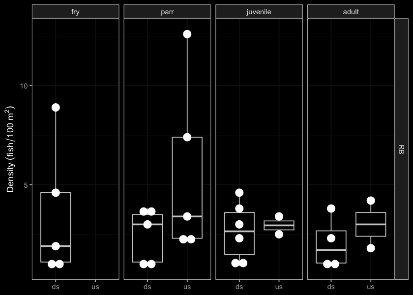
Figure 5.37: Densites of fish (fish/100m2) captured upstream of PSCIS crossing 58067.
my_photo1 <- fpr::fpr_photo_pull_by_str(str_to_pull = '_d1_')

my_caption1 <- paste0('Typical habitat downstream of PSCIS crossing ', my_site, '.')
Figure 5.38: Typical habitat downstream of PSCIS crossing 58067.
my_photo2 <- fpr::fpr_photo_pull_by_str(str_to_pull = '_d2_')

my_caption2 <- paste0('Typical habitat downstream of PSCIS crossing ', my_site, '.')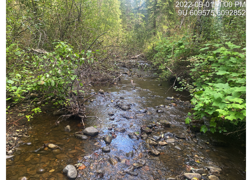
Figure 5.39: Typical habitat downstream of PSCIS crossing 58067.
my_caption <- paste0('Left: ', my_caption1, ' Right: ', my_caption2)

knitr::include_graphics(my_photo1)
knitr::include_graphics("fig/pixel.png")
knitr::include_graphics(my_photo2)
my_photo1 <- fpr::fpr_photo_pull_by_str(str_to_pull = '_u1_')
my_caption1 <- paste0('Typical habitat upstream of PSCIS crossing ', my_site, '.')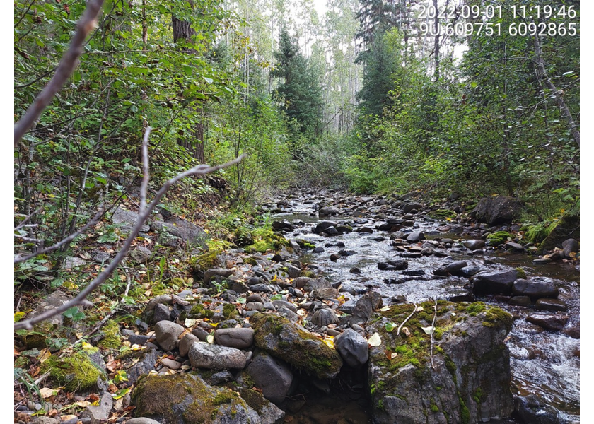
Figure 5.40: Typical habitat upstream of PSCIS crossing 58067.
my_photo2 <- fpr::fpr_photo_pull_by_str(str_to_pull = '_u2_')

my_caption2 <- paste0('Typical habitat upstream of PSCIS crossing ', my_site, '.')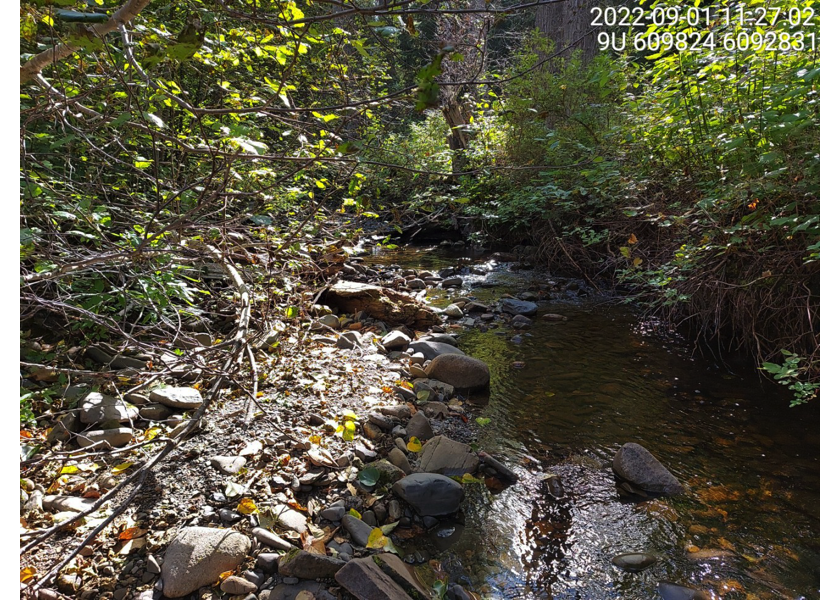
Figure 5.41: Typical habitat upstream of PSCIS crossing 58067.
my_caption <- paste0('Left: ', my_caption1, ' Right: ', my_caption2)

knitr::include_graphics(my_photo1)
knitr::include_graphics("fig/pixel.png")
knitr::include_graphics(my_photo2)
my_photo1 <- fpr::fpr_photo_pull_by_str(str_to_pull = '_u3_')
my_caption1 <- paste0('Typical habitat upstream of PSCIS crossing ', my_site, '.')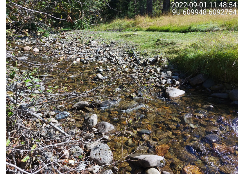
Figure 5.42: Typical habitat upstream of PSCIS crossing 58067.
my_photo2 <- fpr::fpr_photo_pull_by_str(str_to_pull = '_u4_')

my_caption2 <- paste0('Typical habitat upstream of PSCIS crossing ', my_site, '.')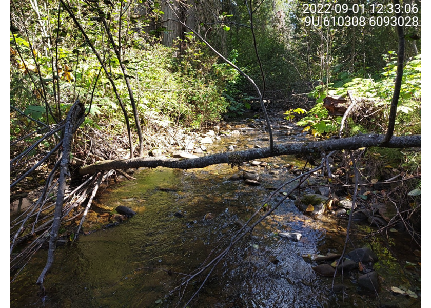
Figure 5.43: Typical habitat upstream of PSCIS crossing 58067.
my_caption <- paste0('Left: ', my_caption1, ' Right: ', my_caption2)

knitr::include_graphics(my_photo1)
knitr::include_graphics("fig/pixel.png")
knitr::include_graphics(my_photo2)
my_caption1 <- "Canyon with 1.5m high rock outcrop located ~600m upstream from the confluence with the Bulkley River."
my_photo2 <- "data/photos/58067/2023/20230924_141057_58067_k_ds2_canyon.JPG"
Figure 5.44: Canyon with 1.5m high rock outcrop located ~600m upstream from the confluence with the Bulkley River.
my_caption2 <- "25 meter rock chute located in the canyon"
my_photo2 <- "data/photos/58067/2023/20230924_141113_58067_k_ds2_chute.JPG"
Figure 5.45: 25 meter rock chute located in the canyon
my_caption <- paste0('Left: ', my_caption1, ' Right: ', my_caption2)

knitr::include_graphics(my_photo1)
knitr::include_graphics("fig/pixel.png")
knitr::include_graphics(my_photo2)
my_caption1 <- "Coho parr captured below the lower rock outcrop and rock chute with dip nets during 2023 sampling."
my_photo1 <- "data/photos/58067/2023/IMG_2843_k_f1.JPG"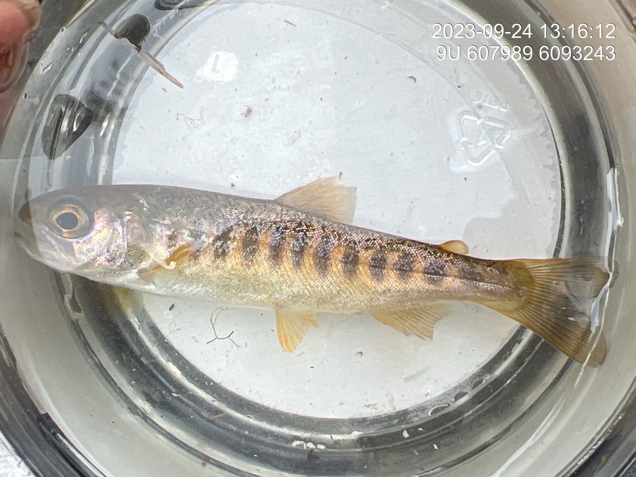
Figure 5.46: Coho parr captured below the lower rock outcrop and rock chute with dip nets during 2023 sampling.
my_caption2 <- "Coho parr captured below the lower rock outcrop and rock chute with dip nets during 2023 sampling."
my_photo2 <- "data/photos/58067/2023/IMG_2876_k_f3.JPG"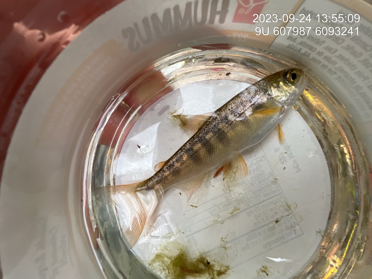
Figure 5.47: Coho parr captured below the lower rock outcrop and rock chute with dip nets during 2023 sampling.