Stock Creek - 195943 & 195944 - Appendix
Site Location
PSCIS crossing 195943 is located approximately 12km north west of Houston, BC. The site is located on Barrett Station Rd, approximately 2.5km upstream from the confluence with the Bulkley River. PSCIS crossing 195944 is located on Highway 16, approximately 850m upstream of crossing 195943. Both crossings are the responsibility of the Ministry of Transportation and Infrastructure.
Background
At crossing 195943, Stock Creek is a third order stream with a watershed area upstream of the crossing of approximately 14.3km2. The elevation of the watershed ranges from a maximum of 1274m to 636m at the crossing (Table 5.1). Although coho and chinook salmon have been observed just downstream of the railway crossing in the past, there is no fisheries information within provincial databases for the areas upstream of crossings 195943 and 195944 (Knowledge Management 2022; Norris [2018] 2022). At the time of reporting, Harry Bell owned land adjacent to the creek near the highway and Barrett Station Rd. He reported historical sightings of adult coho and steelhead upstream of Barrett Station Rd. A railway crossing (PSCIS 198112) is located approximately 2km downstream of crossing 195943.
fpr::fpr_table_wshd_sum(site_id = my_site) %>%
  fpr::fpr_kable(caption_text = paste0('Summary of derived upstream watershed statistics for PSCIS crossing ', my_site, '.'),
           footnote_text = 'Elev P60 = Elevation at which 60% of the upstream watershed area is above',
scroll = F)| Site | Area Km | Elev Site | Elev Min | Elev Max | Elev Median | Elev P60 | Aspect |
|---|---|---|---|---|---|---|---|
| 195943 | 14.3 | 636 | 681 | 1274 | 923 | 892 | SW |
| * Elev P60 = Elevation at which 60% of the upstream watershed area is above |
At the time of reporting, Dogwood Environmental Consulting were working on a grazing/fuel reduction pilot project in collaboration with BC Wildfire, the Ministry of Agriculture and BC Cattleman’s Association. The purpose of the work is to reduce fuel load on crown/agricultural land interface and enhance grazing land through targeted grazing and/or through the manual removal of dead standing timber and coarse woody debris. At the time of reporting, Stock Creek, upstream of the assessed Highway 16 crossing, was included within the project area and Dogwood Environmental Consulting noted that they hoped to help range holders mitigate some of the potential impacts related to fuel reduction opening up access to streams by exploring opportunities to prevent cattle from accessing riparian buffers (pers. comm Jenn Atkins, 2022).
PSCIS stream crossings 195943 and 195944 were ranked as high priorities for follow up by Canadian Wildlife Federation due to significant amounts of habitat modelled as upstream of the crossing. Following a review of PSCIS database and modelling outputs Irvine (2018) ranked both crossings as moderate priorities for follow up with habitat confirmations with notes that the stream appeared to be dewatered at both locations in the PSCIS database photos and because the watershed was relatively low in elevation. A total of 11ha of lake and 21ha of wetland is modelled upstream and a summary of habitat modelling outputs is presented in Table 5.2. A map of the watershed is provided in map attachment 093L.114.
| Habitat | Potential | Remediation Gain | Remediation Gain (%) |
|---|---|---|---|
| ST Network (km) | 23.1 | 0.7 | 3 |
| ST Lake Reservoir (ha) | 10.6 | 0.0 | 0 |
| ST Wetland (ha) | 20.6 | 0.0 | 0 |
| ST Slopeclass03 Waterbodies (km) | 2.0 | 0.0 | 0 |
| ST Slopeclass03 (km) | 3.3 | 0.0 | 0 |
| ST Slopeclass05 (km) | 7.5 | 0.2 | 3 |
| ST Slopeclass08 (km) | 5.7 | 0.5 | 9 |
| ST Spawning (km) | 0.0 | 0.0 | – |
| ST Rearing (km) | 7.9 | 0.7 | 9 |
| CH Spawning (km) | 0.0 | 0.0 | – |
| CH Rearing (km) | 0.0 | 0.0 | – |
| CO Spawning (km) | 0.0 | 0.0 | – |
| CO Rearing (km) | 0.2 | 0.2 | 100 |
| CO Rearing (ha) | – | 0.0 | – |
| SK Spawning (km) | 0.0 | 0.0 | – |
| SK Rearing (km) | 0.0 | 0.0 | – |
| SK Rearing (ha) | – | 0.0 | – |
| All Spawning (km) | 12.0 | 0.7 | 6 |
| All Rearing (km) | 7.9 | 0.7 | 9 |
| All Spawning Rearing (km) | 12.0 | 0.7 | 6 |
| * Model data is preliminary and subject to adjustments. |
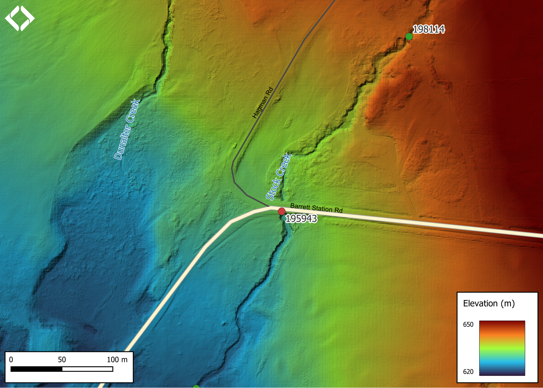
Figure 5.1: Lidar generated digital elevation model of Stock Creek (data collected in 2019, taken from BC Open LiDAR data portal).
5.1 Climate Change Risk Assessment
Preliminary climate change risk assessment data for crossing 195943 is presented in Tables 5.3 - 5.4. Data for highway crossing 195944 is presented in Tables 5.5 - 5.6.
| Condition and Climate Risk | Rank | Priority | Rank |
|---|---|---|---|
| Erosion (scale 1 low - 5 high) | 3 | Traffic Volume 1 (low) 5 (medium) 10 (high) | 2 |
| Embankment fill issues 1 (low) 2 (medium) 3 (high) | 2 | Community Access - Scale - 1 (high - multiple road access) 5 (medium - some road access) 10 (low - one road access) | 2 |
| Blockage Issues 1 (0-30%) 2 (>30-75%) 3 (>75%) | 1 | Cost (scale: 1 high - 10 low) | 6 |
| Condition Rank = embankment + blockage + erosion | 6 | Constructibility (scale: 1 difficult -10 easy) | 7 |
| Likelihood Flood Event Affecting Culvert (scale 1 low - 5 high) | 2 | Environmental Impacts (scale: 1 high -10 low) | 8 |
| Consequence Flood Event Affecting Culvert (scale 1 low - 5 high) | 2 | Fish Bearing 10 (Yes) 0 (No) - see maps for fish points | 10 |
| Climate Change Flood Risk (likelihood x consequence) 1-6 (low) 6-12 (medium) 10-25 (high) | 4 | Priority Rank = traffic volume + community access + cost + constructability + fish bearing + environmental impacts | 35 |
| Vulnerability Rank = Condition Rank + Climate Rank | 10 | Overall Rank = Vulnerability Rank + Priority Rank | 45 |
| Category | Comments |
|---|---|
| Condition | Extensive erosion is present on the right bank on the downstream side. Very large outlet drop and deep outlet pool indicates culvert is undersized. Very little corrosion on the pipe. Pipe shape is good and not deformed. |
| Climate | Only one house visible downstream of the crossing. Road appears to have some traffic volume. Agricultural fields and minimal housing upstream and downstream. |
| Priority | Appears as though Hagaman Road could be used as alternative access to the community, so impact on traffic is not high. |
| Condition and Climate Risk | Rank | Priority | Rank |
|---|---|---|---|
| Erosion (scale 1 low - 5 high) | 1 | Traffic Volume 1 (low) 5 (medium) 10 (high) | 10 |
| Embankment fill issues 1 (low) 2 (medium) 3 (high) | 1 | Community Access - Scale - 1 (high - multiple road access) 5 (medium - some road access) 10 (low - one road access) | 5 |
| Blockage Issues 1 (0-30%) 2 (>30-75%) 3 (>75%) | 1 | Cost (scale: 1 high - 10 low) | 5 |
| Condition Rank = embankment + blockage + erosion | 3 | Constructibility (scale: 1 difficult -10 easy) | 5 |
| Likelihood Flood Event Affecting Culvert (scale 1 low - 5 high) | 1 | Environmental Impacts (scale: 1 high -10 low) | 1 |
| Consequence Flood Event Affecting Culvert (scale 1 low - 5 high) | 5 | Fish Bearing 10 (Yes) 0 (No) - see maps for fish points | 10 |
| Climate Change Flood Risk (likelihood x consequence) 1-6 (low) 6-12 (medium) 10-25 (high) | 5 | Priority Rank = traffic volume + community access + cost + constructability + fish bearing + environmental impacts | 36 |
| Vulnerability Rank = Condition Rank + Climate Rank | 8 | Overall Rank = Vulnerability Rank + Priority Rank | 44 |
| Category | Comments |
|---|---|
| Condition | Condition appears to be good. There is no evidence of deformity and corrosion is minimal. |
| Climate | Fill is deep enough that a flood event would not affect the culvert. |
| Priority | It would be difficult to do any construction on this section due to large amounts of fill. This site is located on a major highway, possibility for detours but cost would be high. |
Stream Characteristics at Crossings
At the time of the survey, PSCIS crossing 195943 was un-embedded, non-backwatered, had a culvert outlet drop of 1.1m and ranked as a barrier to upstream fish passage according to the provincial protocol (MoE 2011b) (Table 5.7). Water temperature was 14\(^\circ\)C, pH was 8.1 and conductivity was 343uS/cm.
PSCIS crossing 195944 was un-embedded, non-backwatered and ranked as a barrier to upstream fish passage. The culvert length was 167m, the fill depth was estimated at 35m and the outlet drop was measured at 1.5m (Table 5.8).
| Location and Stream Data |
|
Crossing Characteristics | – |
|---|---|---|---|
| Date | 2022-08-30 | Crossing Sub Type | Oval Culvert |
| PSCIS ID | 195943 | Diameter (m) | 2 |
| External ID | – | Length (m) | 14 |
| Crew | MW TP AI VJ AN DN | Embedded | No |
| UTM Zone | 9 | Depth Embedded (m) | – |
| Easting | 645434 | Resemble Channel | No |
| Northing | 6035035 | Backwatered | No |
| Stream | Stock Creek | Percent Backwatered | – |
| Road | Barrett Station Rd | Fill Depth (m) | 0.6 |
| Road Tenure | MoTi | Outlet Drop (m) | 1.1 |
| Channel Width (m) | 3 | Outlet Pool Depth (m) | 0.71 |
| Stream Slope (%) | 3 | Inlet Drop | No |
| Beaver Activity | No | Slope (%) | 1.5 |
| Habitat Value | Medium | Valley Fill | Deep Fill |
| Final score | 31 | Barrier Result | Barrier |
| Fix type | Replace with New Open Bottom Structure | Fix Span / Diameter | 15 |
Photos: From top left clockwise: Road/Site Card, Barrel, Outlet, Downstream, Upstream, Inlet.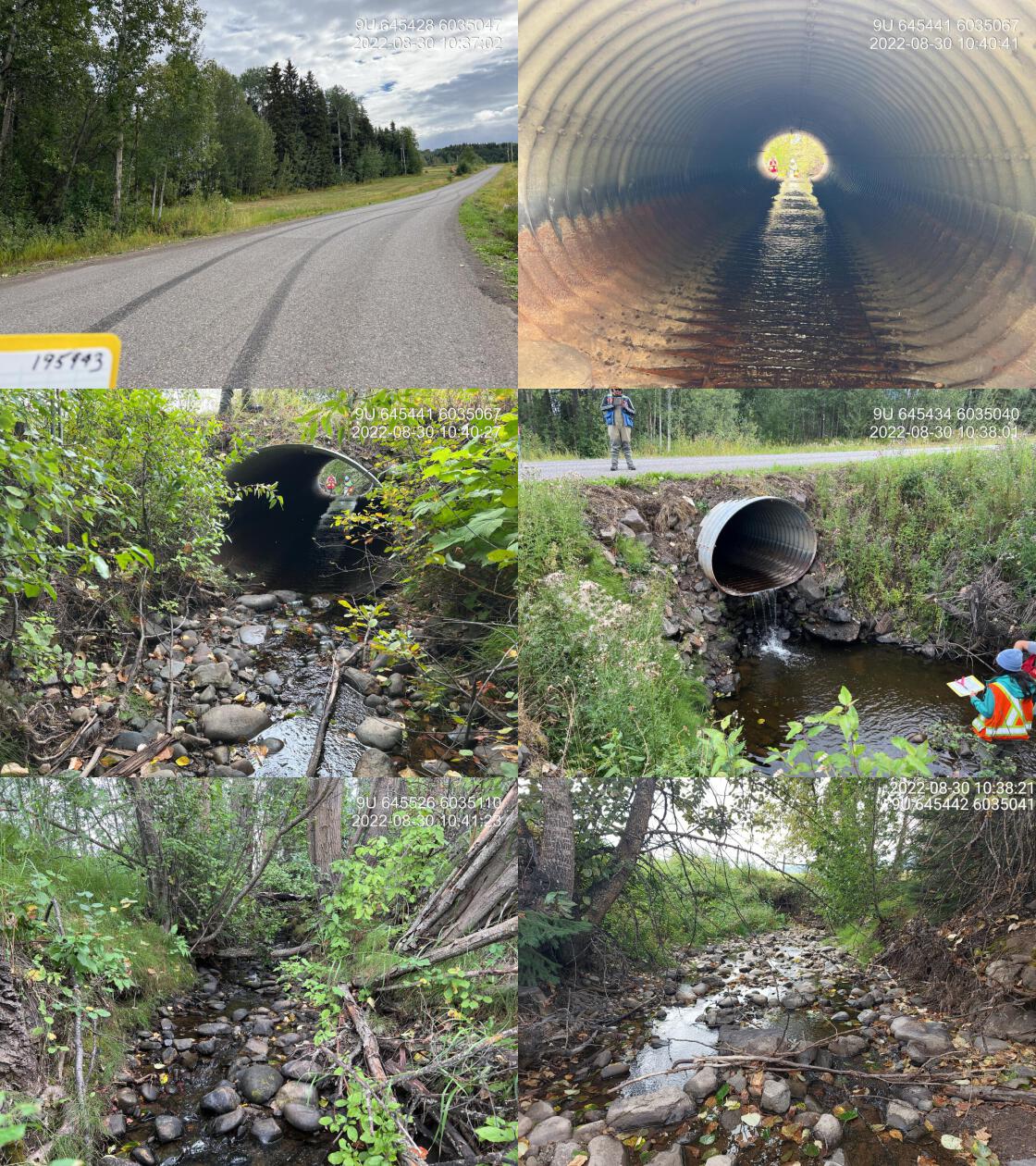
|
|||
| Comments: Very large outlet drop, but creates nice pool for fish. Erosion on left and right bank on outlet side. Agricultural fields, minimal municipality population downstream. Road is paved, detour available. 10:25 |
| Location and Stream Data |
|
Crossing Characteristics | – |
|---|---|---|---|
| Date | 2022-08-30 | Crossing Sub Type | Round Culvert |
| PSCIS ID | 195944 | Diameter (m) | 1.8 |
| External ID | – | Length (m) | 99 |
| Crew | MW TP AI VJ AN DN | Embedded | No |
| UTM Zone | 9 | Depth Embedded (m) | – |
| Easting | 646015.2 | Resemble Channel | No |
| Northing | 6035570 | Backwatered | No |
| Stream | Stock Creek | Percent Backwatered | – |
| Road | Highway 16 | Fill Depth (m) | 9.99 |
| Road Tenure | MoTi | Outlet Drop (m) | 1.5 |
| Channel Width (m) | 2.6 | Outlet Pool Depth (m) | 0.25 |
| Stream Slope (%) | 2 | Inlet Drop | No |
| Beaver Activity | No | Slope (%) | 3.5 |
| Habitat Value | Medium | Valley Fill | Deep Fill |
| Final score | 42 | Barrier Result | Barrier |
| Fix type | Replace with New Open Bottom Structure | Fix Span / Diameter | 15 |
Photos: From top left clockwise: Road/Site Card, Barrel, Outlet, Downstream, Upstream, Inlet.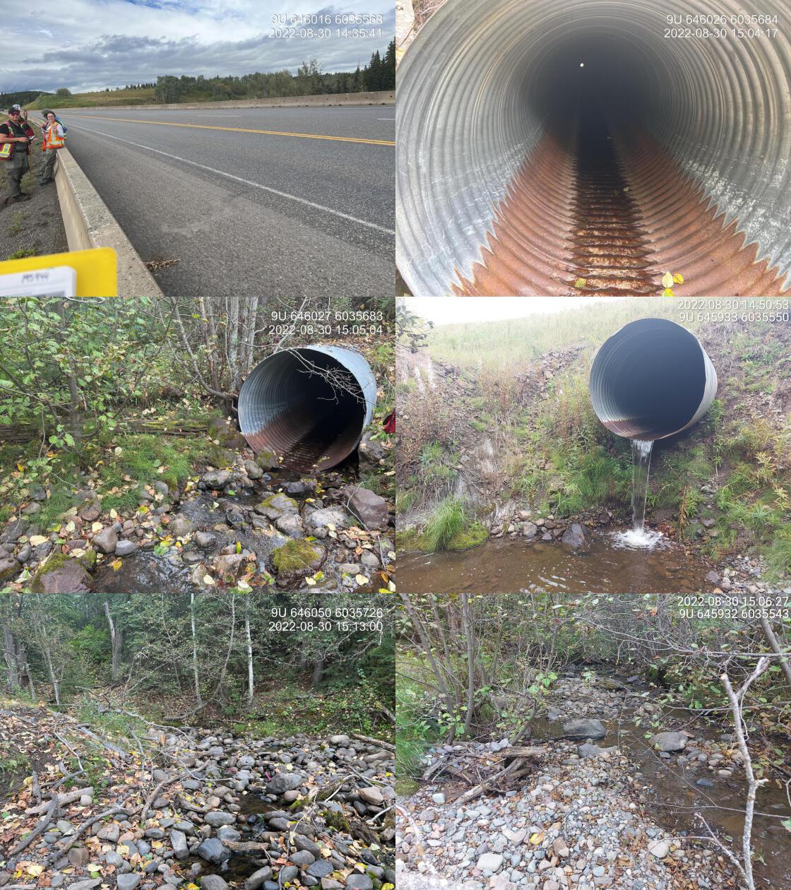
|
|||
| Comments: Length 167 m. Fill depth estimated at approximately 35 m. 14:35 |
##this is useful to get some comments for the report
hab_site %>% filter(site == my_site & location == 'us') %>% pull(comments)
fpr::fpr_my_priority_info()
Stream Characteristics Downstream of 195943
The stream was surveyed downstream from crossing 195943 for 300m (Figures 5.2 - 5.3). <<<<<<< Updated upstream The dominant substrate was gravels with cobbles sub-dominant.The average channel width was 3.8m, the average wetted width was 1.8m, and the average gradient was 2.7%.Total cover amount was rated as moderate with small woody debris dominant. Cover was also present as boulders. A footbridge was present approximately 200m downstream with concrete slabs on both adjacent banks upstream. Multiple fish up to 10cm in length were observed in a pool near the bridge. The stream had minimal overhanging and riparian vegetation in the area surveyed due to adjacent agricultural use. Some areas of stream had pools formed by small dams likely built for livestock waterholes. The habitat was rated as medium value for salmonid rearing and spawning.
======= The dominant substrate was gravels with cobbles sub-dominant.Total cover amount was rated as moderate with small woody debris dominant. Cover was also present as boulders.The average channel width was 3.8m, the average wetted width was 1.8m, and the average gradient was 2.7%. A footbridge was present approximately 200m downstream with concrete slabs on both adjacent banks upstream. Multiple fish up to 10cm in length were observed in a pool near the bridge. The stream had minimal overhanging and riparian vegetation in the area surveyed due to adjacent agricultural use. Some areas of stream had pools formed by small dams likely built for livestock waterholes. The habitat was rated as medium value for salmonid rearing and spawning. >>>>>>> Stashed changesPSCIS crossing 198112 located aproximatley 600 downstream of Barrett Station Rd on the CN Railway was assessed and ranked as passable to all species and life stages at the time of survey. The crossing was embedded and fully backwatered (Table 5.9). Adjacent of the crossing the area was beaver influenced wetland habitat.
| Location and Stream Data |
|
Crossing Characteristics | – |
|---|---|---|---|
| Date | 2022-08-30 | Crossing Sub Type | Concrete Box |
| PSCIS ID | 198112 | Diameter (m) | 2.5 |
| External ID | 1805507 | Length (m) | 14 |
| Crew | AI, DN, AN | Embedded | Yes |
| UTM Zone | 9 | Depth Embedded (m) | 0.4 |
| Easting | 645034 | Resemble Channel | Yes |
| Northing | 6033148 | Backwatered | Yes |
| Stream | Stock Creek | Percent Backwatered | 100 |
| Road | CN Railway | Fill Depth (m) | 0.5 |
| Road Tenure | CN Rail | Outlet Drop (m) | 0 |
| Channel Width (m) | 2.5 | Outlet Pool Depth (m) | 0.2 |
| Stream Slope (%) | 0 | Inlet Drop | No |
| Beaver Activity | Yes | Slope (%) | 0 |
| Habitat Value | Medium | Valley Fill | Deep Fill |
| Final score | 8 | Barrier Result | Passable |
| Fix type | – | Fix Span / Diameter | – |
Photos: From top left clockwise: Road/Site Card, Barrel, Outlet, Downstream, Upstream, Inlet.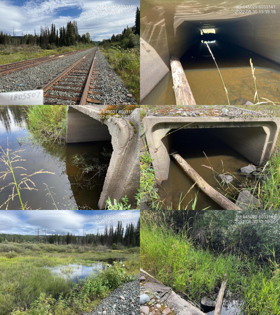
|
|||
| Comments: Fully backwatered and embedded concrete box structure on the Railway. Not a fish passage issue at this time. 13:37 |
Stream Characteristics Upstream of 195943 and Downstream of 195944
The stream was surveyed upstream from crossing 195943 for 330m
(Figures 5.4 - 5.5).
<<<<<<< Updated upstream
The average channel width was 3.1m, the average wetted width was 1.8m, and the average gradient was 2.1%.Total cover amount was rated as abundant with boulders dominant. Cover was also present as undercut banks.The dominant substrate was cobbles with boulders sub-dominant. Good flow volumes were noted along with a decent amount of complexity due to boulders and undercut banks. There were small pockets of gravel suitable for resident rainbow as well as coho and steelhead spawning. The channel appeared to be constricted with riparian vegetation removed on both sides of the stream, likely due to agricultural development. Irrigation pipes in the channel indicated water withdrawal was occurring. The
=======
Total cover amount was rated as abundant with boulders dominant. Cover was also present as undercut banks.The average channel width was 3.1m, the average wetted width was 1.8m, and the average gradient was 2.1%.The dominant substrate was cobbles with boulders sub-dominant. Good flow volumes were noted along with a decent amount of complexity due to boulders and undercut banks. There were small pockets of gravel suitable for resident rainbow as well as coho and steelhead spawning. The channel appeared to be constricted with riparian vegetation removed on both sides of the stream, likely due to agricultural development. Irrigation pipes in the channel indicated water withdrawal was occurring. The
>>>>>>> Stashed changes
habitat was rated as medium value as
an important migration corridor containing suitable spawning habitat and
having moderate rearing potential for juvenile coho, steelhead and other salmonids.
The stream was surveyed downstream from crossing 195944 for 300m. The dominant substrate was cobbles with boulders sub-dominant.The average channel width was 4.1m, the average wetted width was 1.5m, and the average gradient was 3.2%.Total cover amount was rated as trace with boulders dominant. Cover was also present as small woody debris, large woody debris, undercut banks, and overhanging vegetation. There were many undercut banks throughout, with fish up to 20cm long sighted throughout covered areas. There was a cattle trail next to the stream, with significan areas of streambank impacted by erosion. Minimal quantities of gravel suitable for spawning were observed. Although riparian vegetation in the upper portions of the area surveyed =======
The stream was surveyed downstream from crossing 195944 for 300m. The average channel width was 4.1m, the average wetted width was 1.5m, and the average gradient was 3.2%.Total cover amount was rated as trace with boulders dominant. Cover was also present as small woody debris, large woody debris, undercut banks, and overhanging vegetation.The dominant substrate was cobbles with boulders sub-dominant. There were many undercut banks throughout, with fish up to 20cm long sighted throughout covered areas. There was a cattle trail next to the stream, with significan areas of streambank impacted by erosion. Minimal quantities of gravel suitable for spawning were observed. Although riparian vegetation in the upper portions of the area surveyed >>>>>>> Stashed changes habitat was rated as medium value as an with occasional pockets of habitat suitable for resident/anadromous salmonid spawning and moderate rearing potential for juvenile salmonids.
Stream Characteristics Upstream of 195944
The stream was surveyed upstream from crossing 195944 for 640m (Figure 5.6). The average channel width was 4.2m, the average wetted width was 1.8m, and the average gradient was 2%.The dominant substrate was boulders with cobbles sub-dominant.Total cover amount was rated as moderate with boulders dominant. Cover was also present as small woody debris and undercut banks. Within the areas surveyed, the stream was noted as heavily impacted by cattle activity with significant amounts of manure in the stream, degraded/removed riparian vegetation and extensive areas of trampled banks. There were occasional pockets of gravel suitable for resident rainbow spawning. Field notes indicate, occasional pools with depths suitable for juvenile salmon and adult resident salmonid overwintering. A rock drop of 65cm was located 365m upstream of the top end of the culvert (Figure 5.7). This drop would likely be passable for adult salmonids but dependent on flow conditions, could prevent upstream migration for for younger life stages of anadromous fish as well as non-adult resident species.
Structure Remediation and Cost Estimate
Replacement of PSCIS crossing 195943 with a bridge (15m span) is recommended. The cost of the work was estimated at $2,000,000 for a cost benefit of 370 linear m/$1000 and 555 m2/$1000. Replacement of PSCIS crossing 195944 with a bridge (15m span) will have significant costs ($1,500,000) due to the length of the structure and depth of fill. A cost benefit is estimated 4786.7 linear m/$1000 and 6222.7 m2/$1000.
Conclusion
Crossing 195943 was ranked as a high priority for proceeding to design for replacement with a bridge with 0.7km of habitat present upstream before the highway 16 crossing rated as medium value for resident rainbow, coho and steelhead rearing and spawning. Crossing 195944 was ranked as a high priority for proceeding to design for replacement with a bridge with 7.2km of habitat modelled as present upstream. Heavily impacted by range use, the habitat surveyed upstream of this culvert was rated as medium value.
At the time of assessment, Stock Creek was heavily impacted by land clearing and cattle throughout all areas surveyed due to trampled banks and grazed or removed riparian vegetation. It is encouraging that range holders, the province and consultants (ie. Dogwood Environmental Consulting) hope to mitigate some of the potential impacts related to fuel reduction work ongoing at the time of reporting by exploring opportunities to prevent cattle from accessing riparian buffers. It is recommended that an overall plan also be developed to restore the riparian areas and further mitigate range use impacts on stream health. Historic information from the site indicate that flows can be minimal during dry periods. An analysis of land cover and water withdrawal for the greater watershed could provide valuable information as to inform restoration planning such as potentially reversible land use impacts that may exacerbate drought (ex. historic wetland drainage, multiple points of water diversion, vegetation removal, etc). Historical sightings of adult coho and steelhead upstream of Barrett Station Road by the landowner adjacent to crossing 195943 indicate that the stream was historically suitable for these species and the lower reaches’ location near the Bulkley River mainsten position it for likely utilization by numerous fish species when flows are adequate. These insights and the large size of the outlet drop from the pipe under Barrett Station Rd position this site as A good candidate for fish passage restoration.
tab_hab_summary %>%
  filter(Site  == my_site | Site == my_site2) %>%
  # select(-Site) %>%
  fpr::fpr_kable(caption_text = paste0('Summary of habitat details for PSCIS crossing ', my_site, ' and ', my_site2, '.'),
scroll = F) | Site | Location | Length Surveyed (m) | Channel Width (m) | Wetted Width (m) | Pool Depth (m) | Gradient (%) | Total Cover | Habitat Value |
|---|---|---|---|---|---|---|---|---|
| 195943 | Downstream | 300 | 3.8 | 1.8 | 0.4 | 2.7 | moderate | medium |
| 195943 | Upstream | 330 | 3.1 | 1.8 | 0.3 | 2.1 | abundant | medium |
| 195944 | Downstream | 300 | 4.1 | 1.5 | 0.3 | 3.2 | trace | medium |
| 195944 | Upstream | 640 | 4.2 | 1.8 | 0.3 | 2.0 | moderate | medium |
my_photo1 = fpr::fpr_photo_pull_by_str(str_to_pull = '_d1_')

my_caption1 = paste0('Habitat downstream of PSCIS crossing ', my_site, '.')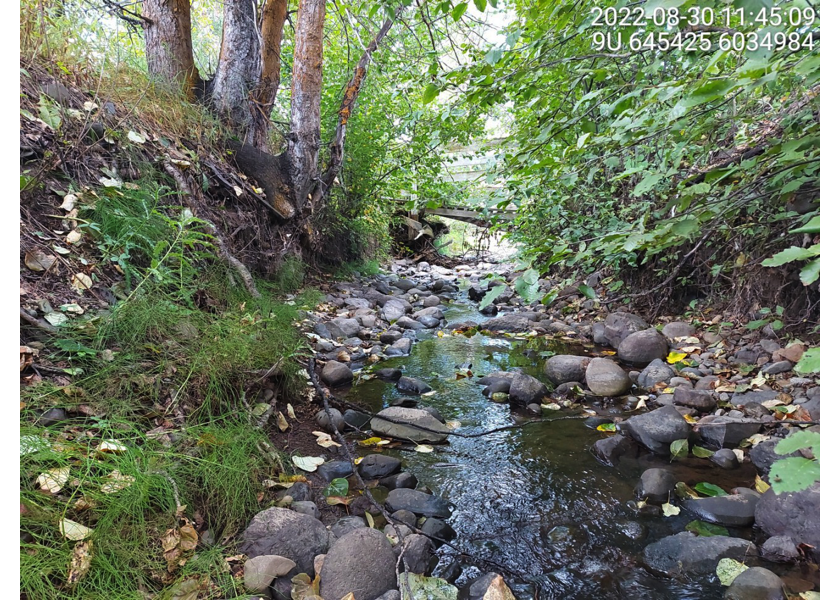
Figure 5.2: Habitat downstream of PSCIS crossing 195943.
my_photo2 = fpr::fpr_photo_pull_by_str(str_to_pull = '_d2_')

my_caption2 = paste0('Habitat downstream of PSCIS crossing ', my_site, '.')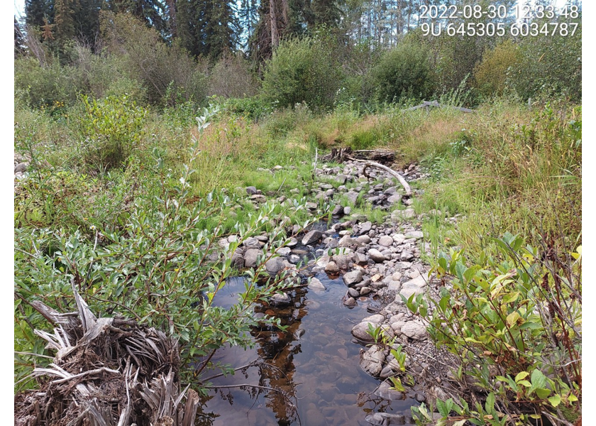
Figure 5.3: Habitat downstream of PSCIS crossing 195943.
my_caption <- paste0('Left: ', my_caption1, ' Right: ', my_caption2)

knitr::include_graphics(my_photo1)
knitr::include_graphics("fig/pixel.png")
knitr::include_graphics(my_photo2)
my_photo1 = fpr::fpr_photo_pull_by_str(str_to_pull = '_u1_')
my_caption1 = paste0('Habitat upstream of PSCIS crossing ', my_site, '.')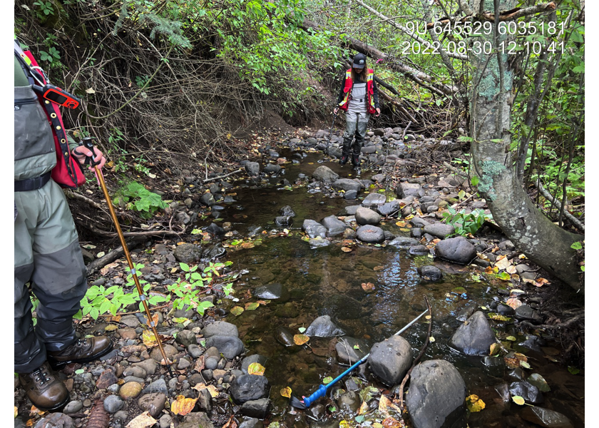
Figure 5.4: Habitat upstream of PSCIS crossing 195943.
my_photo2 = fpr::fpr_photo_pull_by_str(str_to_pull = '_u2_')

my_caption2 = paste0('Habitat upstream of PSCIS crossing ', my_site, '.')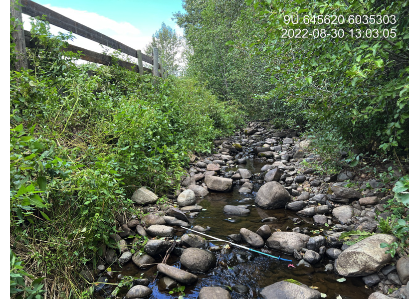
Figure 5.5: Habitat upstream of PSCIS crossing 195943.
my_caption <- paste0('Left: ', my_caption1, ' Right: ', my_caption2)

knitr::include_graphics(my_photo1)
knitr::include_graphics("fig/pixel.png")
knitr::include_graphics(my_photo2)
my_photo1 = fpr::fpr_photo_pull_by_str(site = my_site2, str_to_pull = '_u1_')
my_caption1 = paste0('Habitat upstream of PSCIS crossing ', my_site2, '.')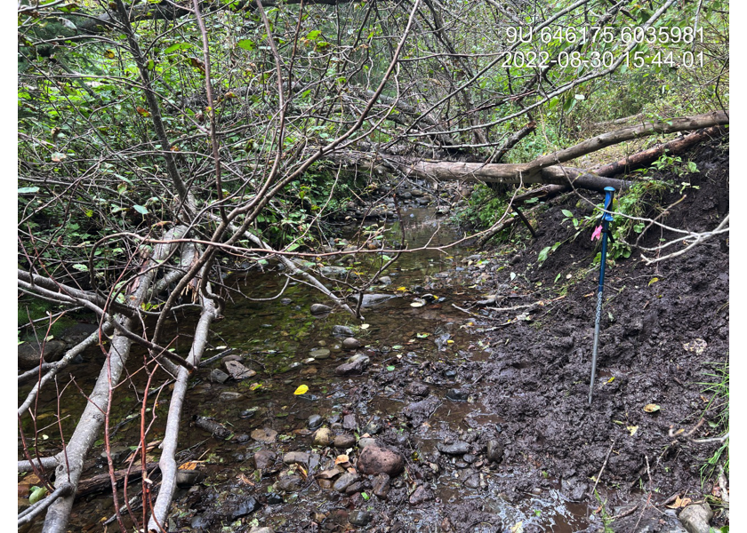
Figure 5.6: Habitat upstream of PSCIS crossing 195944.
my_photo2 = fpr::fpr_photo_pull_by_str(site = my_site2, str_to_pull = '_u2_')

my_caption2 = paste0('A 0.65m high rock drop located 365m upstream of PSCIS crossing ', my_site2, '.')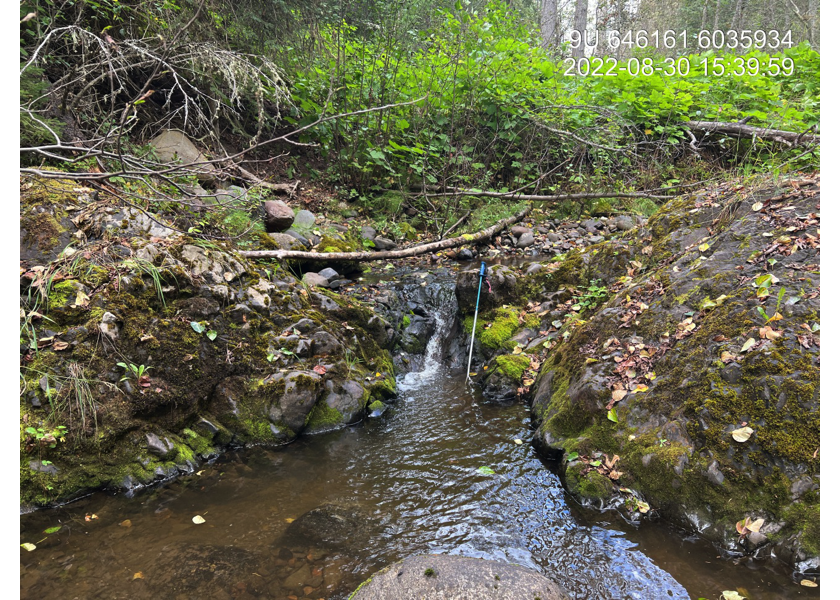
Figure 5.7: A 0.65m high rock drop located 365m upstream of PSCIS crossing 195944.
my_caption <- paste0('Left: ', my_caption1, ' Right: ', my_caption2)

knitr::include_graphics(my_photo1)
knitr::include_graphics("fig/pixel.png")
knitr::include_graphics(my_photo2)