Vallee Creek - 57793 - Appendix
Site Location
PSCIS crossing 57793 is located on Vallee Creek, approximately 30km north west of Houston, BC. The site is located on Walcott Rd. Crossing 57793 was located 1.9km upstream from the confluence with the Bulkley River. Crossing 57793 is the responsibility of the Ministry of Transportation and Infrastructure.
Background
At crossing 57793, Vallee Creek is a third order stream with a watershed area upstream of the crossing of approximately 21.7km2. The elevation of the watershed ranges from a maximum of 1370m to 646m near the crossing (Table 5.29). Upstream of crossing 57793, longnose sucker, cutthroat trout, rainbow trout, and coastrange sculpin (formerly aleutian sculpin) have previously been recorded (MoE 2020b; Norris 2020).
fpr::fpr_table_wshd_sum(site_id = my_site) %>%
  fpr::fpr_kable(caption_text = paste0('Summary of derived upstream watershed statistics for PSCIS crossing ', my_site, '.'),
           footnote_text = 'Elev P60 = Elevation at which 60% of the watershed area is above',
scroll = F)| Site | Area Km | Elev Site | Elev Min | Elev Max | Elev Median | Elev P60 | Aspect |
|---|---|---|---|---|---|---|---|
| 57793 | 21.7 | 617 | 646 | 1370 | 847 | 828 | SW |
| * Elev P60 = Elevation at which 60% of the watershed area is above |
Further downstream, GIS modelling indicates there is one crossing on a transmission line (modelled crossing ID 1802482). A local landowner reported that this crossing does not exist. Review of GIS indicates there is a modelled crossing (ID 1800041) located on the mainstem approximately 5.5km upstream of 57793, on Vallee Creek Road. Additionally, there are several modelled crossings upstream of subject site 57793, located on tributaries that are likely very small. A total of 29ha of lake and 59ha of wetland is modelled upstream. These lakes include Vallee Lake(10ha), Helen Lake(16ha) and other small unnamed lakes that are of insignificant size. Upstream of crossing 1800041, the mainstem drains into Vallee Lake before flowing through the culvert (PSCIS crossing 57801) located on Highway 16. This crossing was listed as a barrier at the time of survey by Gollner, Cain, and Russell (2013) in 2012. Comments indicate that fish were observed downstream, and good habitat was present upstream. Vallee Creek then flows east past the highway through PSCIS crossings 57786, followed by 57787, before draining into Helen Lake.
PSCIS stream crossing 57793 was ranked as a high priority for follow up by the Canadian Wildlife Federation due to significant amounts of habitat modeled upstream. Irvine (2018) ranked the site as a moderate priority for follow up after review of PSCIS data/photos because the site appeared to have low flows, be partially backwatered and have no outlet drop indicating it was likely passable to most species and life stages at the time the initial fish passage assessment was conducted by Gollner, Cain, and Russell (2013) in 2012. A summary of habitat modelling outputs is presented in Table 5.30. A map of the watershed is provided in map attachment 093L.113.
| Habitat | Potential | Remediation Gain | Remediation Gain (%) |
|---|---|---|---|
| ST Network (km) | 31.8 | 16.0 | 50 |
| ST Lake Reservoir (ha) | 29.1 | 2.3 | 8 |
| ST Wetland (ha) | 59.1 | 10.0 | 17 |
| ST Slopeclass03 Waterbodies (km) | 4.5 | 0.0 | 0 |
| ST Slopeclass03 (km) | 9.4 | 4.8 | 51 |
| ST Slopeclass05 (km) | 7.3 | 4.8 | 66 |
| ST Slopeclass08 (km) | 9.9 | 5.3 | 54 |
| ST Spawning (km) | 0.0 | 0.0 | – |
| ST Rearing (km) | 3.4 | 3.4 | 100 |
| CH Spawning (km) | 0.0 | 0.0 | – |
| CH Rearing (km) | 0.0 | 0.0 | – |
| CO Spawning (km) | 1.8 | 1.8 | 100 |
| CO Rearing (km) | 10.1 | 5.6 | 55 |
| CO Rearing (ha) | 27.5 | 0.0 | 0 |
| SK Spawning (km) | 0.0 | 0.0 | – |
| SK Rearing (km) | 0.0 | 0.0 | – |
| SK Rearing (ha) | – | 0.0 | – |
| All Spawning (km) | 23.2 | 13.1 | 56 |
| All Rearing (km) | 10.1 | 5.6 | 55 |
| All Spawning Rearing (km) | 25.3 | 13.5 | 53 |
| * Model data is preliminary and subject to adjustments. |
Stream Characteristics at Crossing
At the time of the survey, PSCIS crossing 57793 was un-embedded, non-backwatered and ranked as a barrier barrier to upstream fish passage according to the provincial protocol (MoE 2011b) (Table 5.31). There was low flow through the culvert at the time of survey. However, a deep outlet pool was present indicating high flows do occur and that the culvert may be undersized. Water temperature was 12\(^\circ\)C, pH was 8 and conductivity was 204uS/cm.
| Location and Stream Data |
|
Crossing Characteristics | – |
|---|---|---|---|
| Date | 2022-08-31 | Crossing Sub Type | Round Culvert |
| PSCIS ID | 57793 | Diameter (m) | 3 |
| External ID | – | Length (m) | 20 |
| Crew | MW DN TP AN | Embedded | No |
| UTM Zone | 9 | Depth Embedded (m) | – |
| Easting | 641460 | Resemble Channel | No |
| Northing | 6044049 | Backwatered | No |
| Stream | Vallee Creek | Percent Backwatered | – |
| Road | Walcott Rd | Fill Depth (m) | 1 |
| Road Tenure | MoTi | Outlet Drop (m) | 0.1 |
| Channel Width (m) | 4.7 | Outlet Pool Depth (m) | 0.5 |
| Stream Slope (%) | 3 | Inlet Drop | No |
| Beaver Activity | No | Slope (%) | 2 |
| Habitat Value | High | Valley Fill | Deep Fill |
| Final score | 24 | Barrier Result | Barrier |
| Fix type | Replace with New Open Bottom Structure | Fix Span / Diameter | 15 |
Photos: From top left clockwise: Road/Site Card, Barrel, Outlet, Downstream, Upstream, Inlet.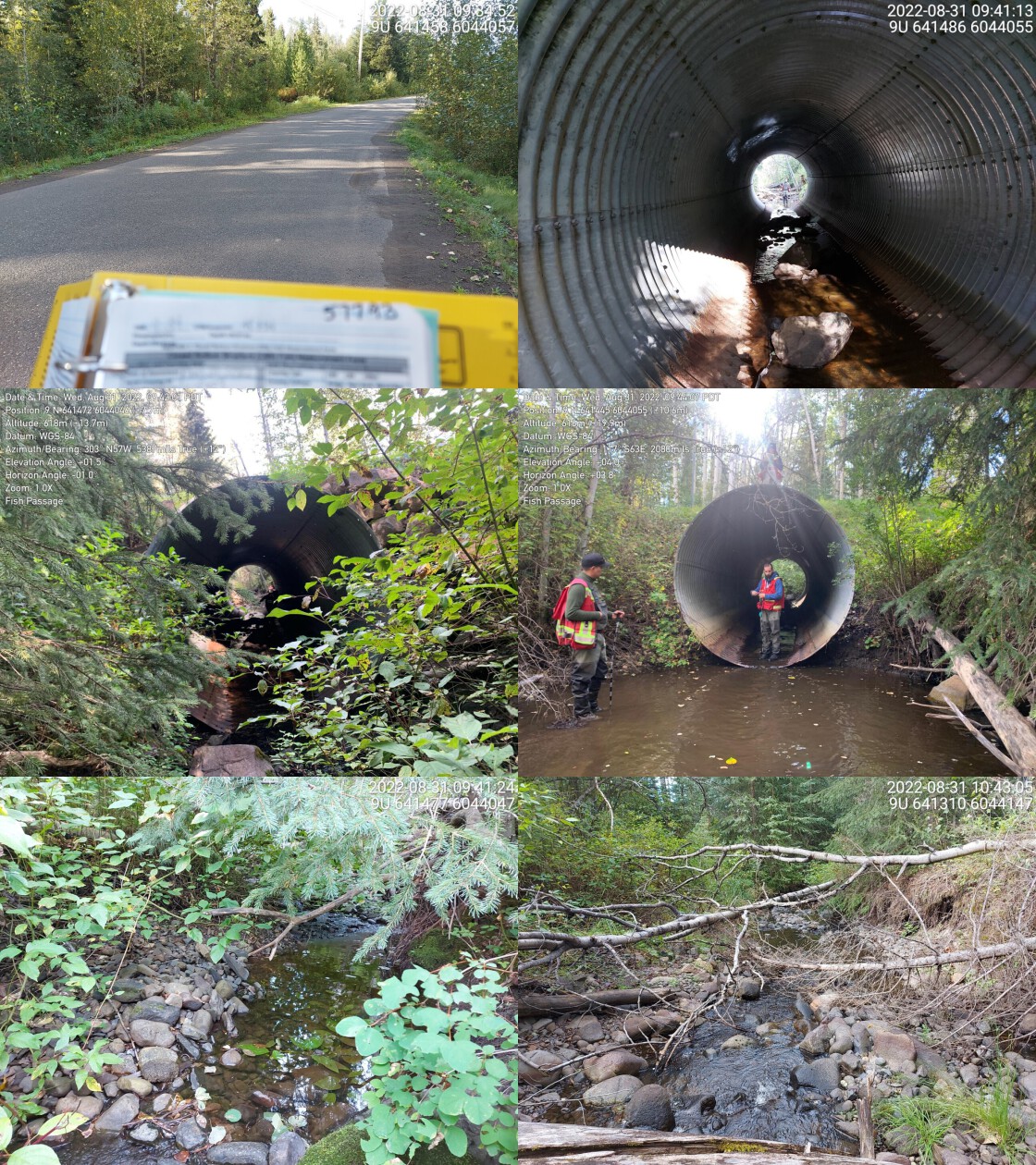
|
|||
| Comments: Slight outlet drop, low water levels would be a fish passage issue. Little amount of water running through culvert. Deep pool at outlet of culvert, good for fish. Boulders in culvert, which are obstacles to fish. 9:34 |
Stream Characteristics Downstream
The stream was surveyed downstream from crossing 57793 for 300m (Figures 5.30 - 5.31). Total cover amount was rated as abundant with undercut banks dominant. Cover was also present as small woody debris, large woody debris, and overhanging vegetation.The dominant substrate was gravels with cobbles sub-dominant.The average channel width was 4.1m, the average wetted width was 2.4m, and the average gradient was 2%. There were undercut banks and abundant riparian vegetation throughout providing good cover for fish. Some gravels were present that could be suitable for spawning. Functional large woody debris was present throughout the stream.The habitat was rated as high value for salmonid rearing and spawning.
Stream Characteristics Upstream
The stream was surveyed upstream from crossing 57793 for 600m (Figures 5.32 - 5.35). The average channel width was 4.1m, the average wetted width was 2m, and the average gradient was 2%.The dominant substrate was cobbles with gravels sub-dominant.Total cover amount was rated as abundant with large woody debris dominant. Cover was also present as small woody debris, undercut banks, and overhanging vegetation. The data for the upstream survey was misplaced and stream characteristics and measurements were obtained by reviewing photos. The habitat quality was excellent. There were abundant undercut banks and healthy mixed riparian vegetation throughout. The stream was wide and contained some pockets of gravel suitable for spawning resident species. The habitat was rated as high value as an important migration corridor containing suitable spawning habitat and having moderate rearing potential.
Structure Remediation and Cost Estimate
Should restoration/maintenance activities proceed, replacement of PSCIS crossing 57793 with a bridge (15m span) is recommended. The cost of the work is estimated at $2,000,000 for a cost benefit of 1720 linear m/$1000 and 4042 m2/$1000.
Conclusion
There was 3.4km of habitat modelled upstream of crossing 57793 with areas surveyed rated as high value for salmonid rearing and spawning. As the culvert outlet drop was small, and because the relatively low elevation of the watershed may result in low flows in typical years (see assessment photos from Gollner, Cain, and Russell (2013) here), 57793 was ranked as a moderate priority for proceeding to design for replacement. Electrofishing upstream and downstream of the culvert is recommended to provide insight into fish community composition and density which may justify a higher priority for site remediation.
tab_hab_summary %>%
  filter(Site  == my_site) %>%
  # select(-Site) %>%
  fpr::fpr_kable(caption_text = paste0('Summary of habitat details for PSCIS crossing ', my_site, '.'),
scroll = F) | Site | Location | Length Surveyed (m) | Channel Width (m) | Wetted Width (m) | Pool Depth (m) | Gradient (%) | Total Cover | Habitat Value |
|---|---|---|---|---|---|---|---|---|
| 57793 | Downstream | 300 | 4.1 | 2.4 | 0.5 | 2 | abundant | high |
| 57793 | Upstream | 600 | 4.1 | 2.0 | – | 2 | abundant | high |
my_photo1 = fpr::fpr_photo_pull_by_str(str_to_pull = '_d1_')

my_caption1 = paste0('Typical habitat downstream of PSCIS crossing ', my_site, '.')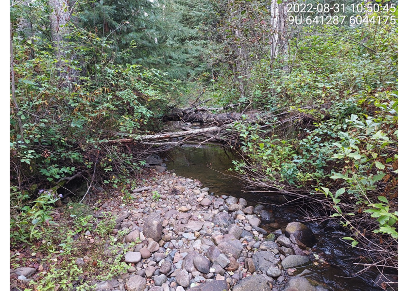
Figure 5.30: Typical habitat downstream of PSCIS crossing 57793.
my_photo2 = fpr::fpr_photo_pull_by_str(str_to_pull = '_d2_')

my_caption2 = paste0('Typical habitat downstream of PSCIS crossing ', my_site, '.')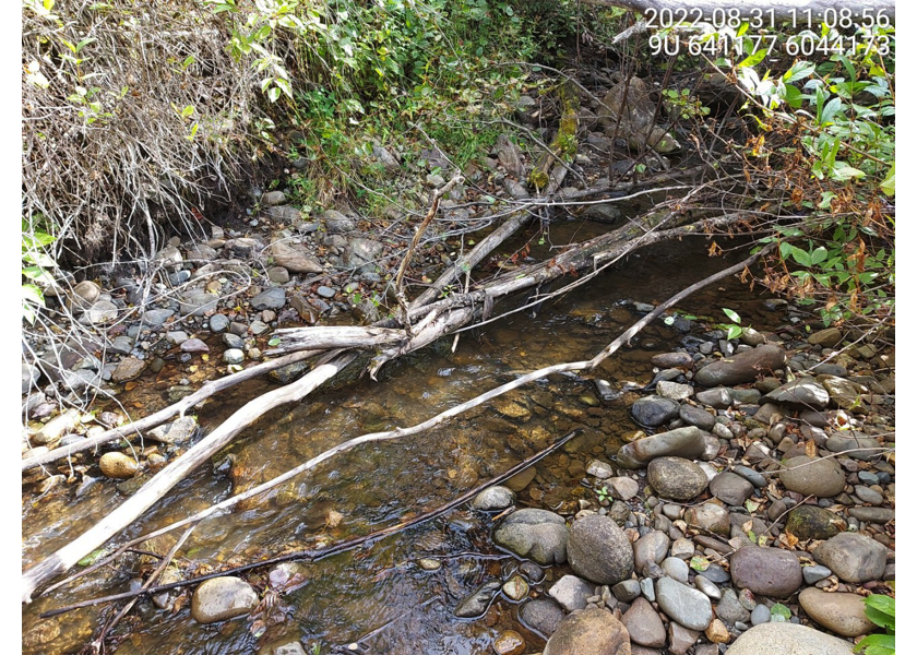
Figure 5.31: Typical habitat downstream of PSCIS crossing 57793.
my_caption <- paste0('Left: ', my_caption1, ' Right: ', my_caption2)

knitr::include_graphics(my_photo1)
knitr::include_graphics("fig/pixel.png")
knitr::include_graphics(my_photo2)
my_photo1 = fpr::fpr_photo_pull_by_str(str_to_pull = '_u1_')
my_caption1 = paste0('Typical habitat upstream of PSCIS crossing ', my_site, '.')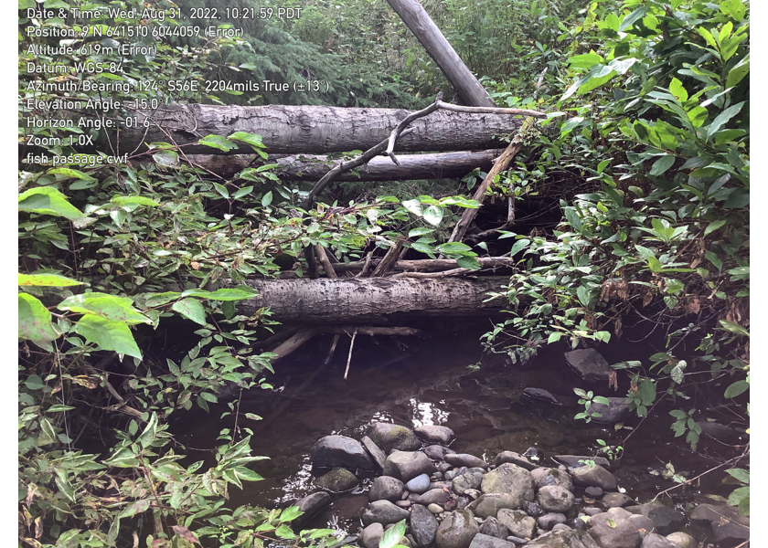
Figure 5.32: Typical habitat upstream of PSCIS crossing 57793.
my_photo2 = fpr::fpr_photo_pull_by_str(str_to_pull = '_u2_')

my_caption2 = paste0('Typical habitat upstream of PSCIS crossing ', my_site, '.')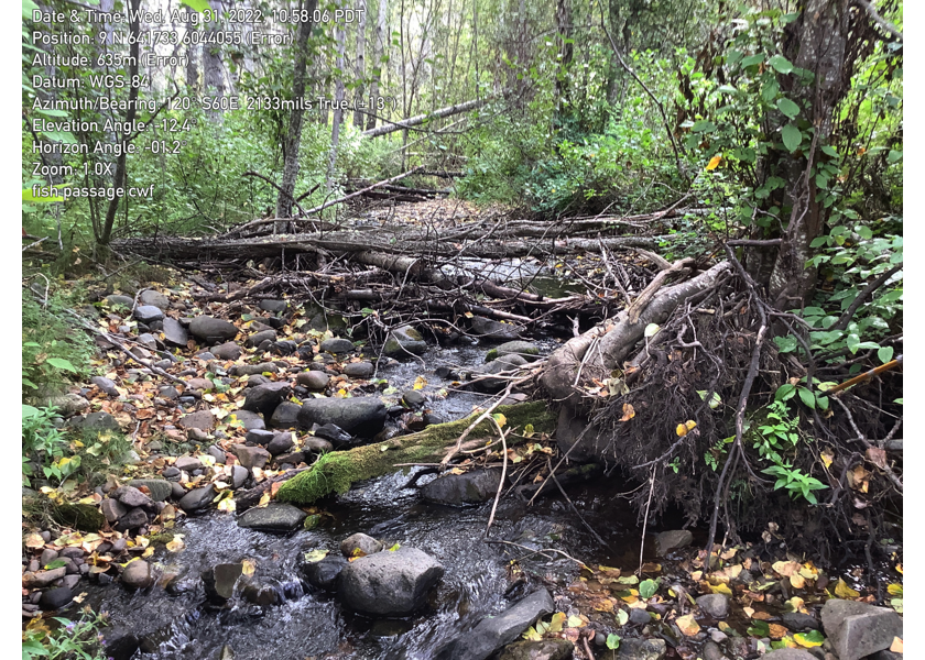
Figure 5.33: Typical habitat upstream of PSCIS crossing 57793.
my_caption <- paste0('Left: ', my_caption1, ' Right: ', my_caption2)

knitr::include_graphics(my_photo1)
knitr::include_graphics("fig/pixel.png")
knitr::include_graphics(my_photo2)
my_photo1 = fpr::fpr_photo_pull_by_str(str_to_pull = '_u3_')
my_caption1 = paste0('Typical habitat upstream of PSCIS crossing ', my_site, '.')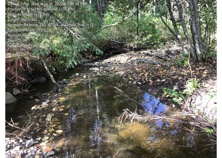
Figure 5.34: Typical habitat upstream of PSCIS crossing 57793.
my_photo2 = fpr::fpr_photo_pull_by_str(str_to_pull = '_u4_')

my_caption2 = paste0('Typical habitat upstream of PSCIS crossing ', my_site, '.')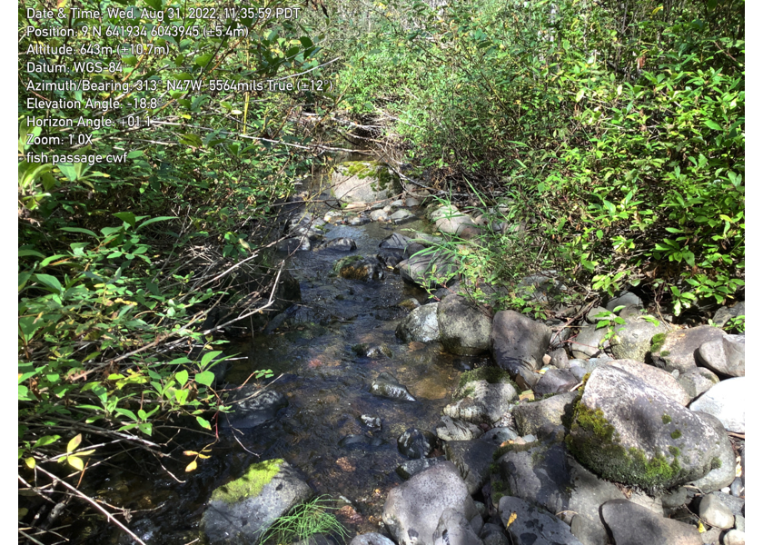
Figure 5.35: Typical habitat upstream of PSCIS crossing 57793.
my_caption <- paste0('Left: ', my_caption1, ' Right: ', my_caption2)

knitr::include_graphics(my_photo1)
knitr::include_graphics("fig/pixel.png")
knitr::include_graphics(my_photo2)