Appendix - 61504 - Coal Creek
Site Location
PSCIS crossing 61504 is located on Coal Creek on the Coal Creek Road 5.5km east of Fernie, BC. Coal Creek Road is classified as an unpaved local road with the Ministry of Transportation and Infrastructure detailed as a custodian partner within the digital road atlas (FLNRORD 2020c). Phil MacDonald (BC Timber Sales Road Manager) has indicated that most the drainage is private land managed forest owned by CanWel Fibre Group.
Background
Coal Creek drains in a western direction from Leach Ridge to the confluence with the Elk River located with the City of Fernie municipal boundaries. At crossing 61504, Coal Creek is a fifth order stream with a watershed area upstream of the crossing of approximately 98.7km2. The elevation of the watershed ranges from a maximum of 2241m to 1132m at PSCIS crossing 61504. Within Coal Creek westslope cutthroat trout and bull trout have been recorded upstream of the subject bridge (MoE 2020a; Norris 2020). There are numerous stream crossing structures located on Coal Creek upstream of 61504 however there are no crossings assessed as barriers on the mainstem.
The site is located to the historic Coal Creek town site where a historic coal mine was located. The town had an estimated 1000 residents in 1905 and operations at the mine ended on January 30, 1958 (Foster and Bachusky 2005).
A large flood event on Coal Creek in 1995 caused overbank flooding, channel shifting, bank erosion, coarse sediment deposition, and damage to private and public property near the stream. Floodplain mapping for the stream was completed in 2014 including an assessment of flood hazards, hydrologic estimates of the 200-year instantaneous design flow, 200-year estimated inundation extents and flood construction levels (Northwest Hydraulic Consultants 2014).
Hughes and Millions (2020) report that riprap to stabilize the streambanks and reduce meandering is frequently employed near existing and historical infrastructure on Coal Creek. Elk River Alliance have drafted a plan to restore the floodpain adjacent to the historic township through removal of invasive species and planting/seeding of native vegetation (Hughes and Millions 2020). A major storm event on November 14-15, 2021 caused extensive damage to Coal Creek Road and changed the course of the river near the historic townsite (Tibballs 2021). This event may have washed out this crossing since the confirmation was completed.
Elk River Alliance (2020) conducted redd surveys in Coal Creek in 2019 along with Morrissey Creek, Lizard Creek and Forsyth Creek. No redds were identified within the 1.3km surveyed within Coal Creek.
The bridge where PSCIS crossing 61504 is located on the outside bend of Coal Creek and has been extensively armored with large riprap on the west side of the river upstream of the bridge likely to protect bridge pilings/abutments. At the time of the survey it appeared as though significant amounts of riprap as well as what appeared to be a historic stream abutment was slightly constricting the channel and creating a small cascade (20 - 55cm high) across the stream width adjacent to the downstream end of the bridge abutments. Through connectivity restoration planning activities, this constriction of the channel and presence of cascade was brought to the attention of Canadian Wildlife Federation and the site was assigned a high priority for follow up. Table 5.1 presents preliminary fish passage modelling data for crossing 61504 with linear length of spawning and rearing habitat estimated for westslope cutthrout trout at 8.5km and 14.5km respectively. A map of the watershed is provided in map attachment 082G.113.
print_tab_summary_bcfp()| Habitat | Potential | Remediation Gain | Remediation Gain (%) |
|---|---|---|---|
| WCT Spawning (km) | 8.5 | 8.5 | 100 |
| WCT Rearing (km) | 14.5 | 14.5 | 100 |
| WCT Stream (km) | 33.1 | 27.7 | 84 |
| WCT Network (km) | 33.1 | 27.7 | 84 |
| WCT Lake Reservoir (ha) | – | 0.0 | – |
| WCT Wetland (ha) | – | 0.0 | – |
| WCT Slopeclass03 Waterbodies (km) | 0.0 | 0.0 | – |
| WCT Slopeclass03 (km) | 4.2 | 4.2 | 100 |
| WCT Slopeclass05 (km) | 4.5 | 4.5 | 100 |
| WCT Slopeclass08 (km) | 10.3 | 7.3 | 71 |
| WCT Slopeclass15 (km) | 13.1 | 10.9 | 83 |
| WCT Slopeclass22 (km) | 0.9 | 0.9 | 100 |
| * Model data is preliminary and subject to adjustments. | |||
| † Modelled rearing habitat estimates do not currently include linear lengths of centrelines within lakes and wetlands. |
Stream Characteristics at Crossing
At the time of the survey, the PSCIS bridge crossing span was measured at 61504 24m and the width was 4m. As an open bottomed structure, the crossing was not considered a barrier or partial barrier to fish passage (Table 5.3). Water temperature was 4\(^\circ\)C, pH was 8.3 and conductivity was 170uS/cm.
To gather data to help assess the degree to which the cascade potentially hindered upstream fish migration, velocity measurements were taken at five locations even distributed across the wetted width of the cascade using a Hach FH handheld flow meter (Figures 5.1 - 5.2). Measurements were taken on October 15, 2021 at depths equivalent to 60% of the depth of the water. Light rain was falling at the time of the survey. Flow velocities at the cascade ranged from 0.31m/s to 0.31m/s (Table 5.2). In a swimming performance study conducted in an open-channel flume Blank et al. (2020) estimated the overall average swim speeds of westlope cutthrout trout (150mm - 290mm in length) at 0.84m/s with a maximum observed swim speed of 3.55m/s.
coal_velocity %>%
  my_kable(
           footnote_text = 'Velocities measured at 60% of wetted depth.  Distance was measured from top of bank.',
caption_text = paste0('Summary of velocities at debris influenced cascade adjacent to PSCIS crossing ', my_site, '.'))| Distance | Velocity |
|---|---|
| 6.6 | 0.31 |
| 7.2 | 0.64 |
| 8.8 | 1.91 |
| 10.6 | 1.15 |
| 12.4 | 1.60 |
| * Velocities measured at 60% of wetted depth. Distance was measured from top of bank. |
##this is useful to get some comments for the report
hab_site %>% filter(site == my_site & location == 'us') %>% pull(comments)
my_priority <-  my_priority_info()
Stream Characteristics Downstream
The stream was surveyed downstream from 61504 for 365m (Figures 5.1 - 5.2). Overall, total cover amount was rated as abundant with boulders dominant undercut banks subdominant (Table 5.4). The average channel width was 27.8m, the average wetted width was 10.5m and the average gradient was 2.8%. The dominant substrate was NA with NA subdominant. Some pockets of gravel suitable for westslope cutthrout trout spawning were observed. Habitat value was rated as high within the large system with abundant habitat available for fry/juvenile salmonid rearing.
Stream Characteristics Upstream
The stream was surveyed upstream from 61504 for 520m (Figures 5.3 - 5.4). Within the area surveyed, total cover amount was rated as abundant with boulders dominant. Cover was also present as large woody debris and deep pools (Table 5.4). The average channel width was 12.1m, the average wetted width was 11.2m and the average gradient was 2.8%. Some deep pools up to ~1.8m deep were available for overwintering westslope cutthroat trout adults and occasional pockets of gravel suitable for spawning were present. The riparian area was comprised of mature black cottonwood with intermittent naturally formed large woody debris structures throughout providing structure and cover. Beaver dams were located within the area surveyed primarily on tributaries or side-channels with one dam noted as partially spanning the main channel. Habitat value was rated as high for salmonid rearing and spawning.
Remediation and Cost Estimate
A rough estimate of the cost of works to remove the debris creating cascade adjacent to PSCIS bridge 61504 is $20,000.
Conclusion
Although the 30 - 55cm high cascade adjacent to PSCIS bridge 61504 is unlikely to be a signifcant barrier for the movement of migrating adult westslope cutthrout trout the obstacle may prevent movement upstream by fry and juveniles. There is an estimated 14.5km of westslope cutthrout trout rearing and/or spawning habitat upstream of crossing 61504. Although, small cascades within stream networks are common and often present opportunities for upstream passage (particularly for adult fish) at different flows, removal of debris from the channel adjacent to 61504 could reduce the risk that the cascade may impact fish migration (particularly for younger life stages). Habitat in the area surveyed was rated as high value for salmonid rearing/spawning as this is a large system with deep pools and gravels present suitable for spawning. Overall, the site was ranked as a high priority for remedial works which would include removal of debris from the channel. However, as noted earlier, a major storm event in November 2021 caused extensive damage to Coal Creek Road and this flood event may have washed out the crossing since the confirmation was completed. A reassessment of the entire Coal Creek Road system once repairs have been completed is recommended.
print_tab_summary()| Location and Stream Data |
|
Crossing Characteristics | – |
|---|---|---|---|
| Date | 2021-10-04 | Crossing Sub Type | Bridge |
| PSCIS ID | 61504 | Diameter (m) | 24 |
| External ID | – | Length (m) | 4 |
| Crew | KP | Embedded | – |
| UTM Zone | 11 | Depth Embedded (m) | – |
| Easting | 645312.9 | Resemble Channel | – |
| Northing | 5483687 | Backwatered | – |
| Stream | Coal Creek | Percent Backwatered | – |
| Road | Coal Creek Road | Fill Depth (m) | – |
| Road Tenure | Unknown | Outlet Drop (m) | – |
| Channel Width (m) | – | Outlet Pool Depth (m) | – |
| Stream Slope (%) | – | Inlet Drop | – |
| Beaver Activity | – | Slope (%) | – |
| Habitat Value | – | Valley Fill | – |
| Final score | 0 | Barrier Result | Passable |
| Fix type | – | Fix Span / Diameter | – |
Photos: From top left clockwise: Road/Site Card, Barrel, Outlet, Downstream, Upstream, Inlet.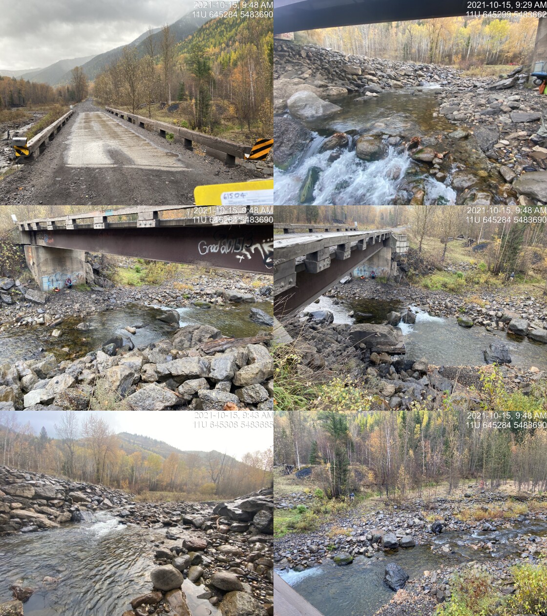
|
|||
| Comments: Habitat confirmation conducted due to debris in stream that causes small drop across stream (0.2 - 0.6m high) just downstream of the bridge. 9:20 |
tab_hab_summary %>%
  filter(Site  == my_site) %>%
  # select(-Site) %>%
my_kable(caption_text = paste0('Summary of habitat details for PSCIS crossings ', my_site, '.'))| Site | Location | Length Surveyed (m) | Channel Width (m) | Wetted Width (m) | Pool Depth (m) | Gradient (%) | Total Cover | Habitat Value |
|---|---|---|---|---|---|---|---|---|
| 61504 | Upstream | 520 | 12.1 | 11.2 | 1.0 | 2.8 | abundant | high |
| 61504 | Downstream | 365 | 27.8 | 10.5 | 0.5 | 2.8 | abundant | high |
my_photo1 = pull_photo_by_str(site_id = my_site, str_to_pull = '_u1_')

my_caption1 = paste0('Cascade adjacent to PSCIS crossing ', my_site, '.')grid::grid.raster(get_img(site = my_site, photo = my_photo1))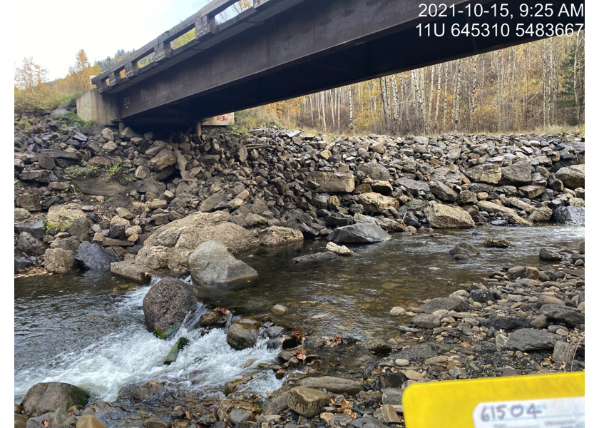
Figure 5.1: Cascade adjacent to PSCIS crossing 61504.
my_photo2 = pull_photo_by_str(site_id = my_site, str_to_pull = '_u2_')

my_caption2 = paste0('Flow velocity measurement adjacent to PSCIS crossing ', my_site, '.')grid::grid.raster(get_img(site = my_site, photo = my_photo2))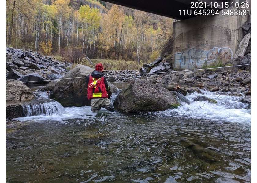
Figure 5.2: Flow velocity measurement adjacent to PSCIS crossing 61504.
##we could put 2 photos in on box but it is lots of extra work with the crossreferences. pdfs suck anyway.  Don't get too custom with it!!!

# my_photo1 = pull_photo_by_str(str_to_pull = '_d1_')
# my_caption1 = paste0('Typical habitat downstream of PSCIS crossing ', my_site, '.')
#
# my_photo2 = pull_photo_by_str(str_to_pull = '_u1_')
# my_caption2 = paste0('Typical habitat upstream of PSCIS crossing ', my_site, '.')

my_caption <- paste0('Left: ', my_caption1, ' Right: ', my_caption2)


my_photo2 = pull_photo_by_str(site_id = my_site, str_to_pull = '_u5_')


knitr::include_graphics(get_img_path(photo = my_photo1))
knitr::include_graphics("fig/pixel.png")
knitr::include_graphics(get_img_path(photo = my_photo2))
my_photo1 = pull_photo_by_str(str_to_pull = '_d1_')
my_caption1 = paste0('Typical habitat downstream of PSCIS crossing ', my_site, '.')grid::grid.raster(get_img(photo = my_photo1))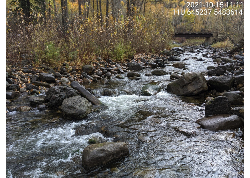
Figure 5.3: Typical habitat downstream of PSCIS crossing 61504.
my_photo2 = pull_photo_by_str(str_to_pull = '_d2_')

my_caption2 = paste0('Typical habitat downstream of PSCIS crossing ', my_site, '.')grid::grid.raster(get_img(photo = my_photo2))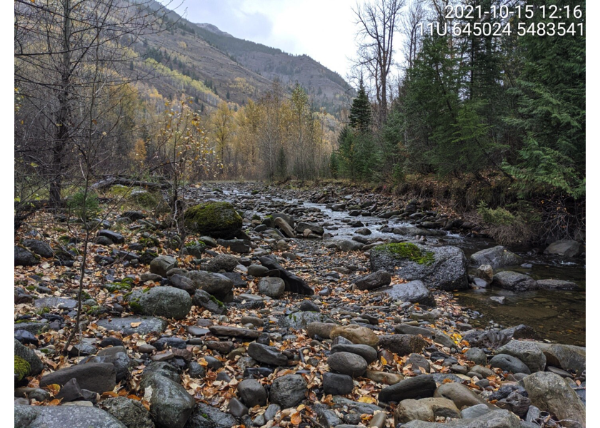
Figure 5.4: Typical habitat downstream of PSCIS crossing 61504.
my_caption <- paste0('Left: ', my_caption1, ' Right: ', my_caption2)

my_photo1 = pull_photo_by_str(site_id = my_site, str_to_pull = '_d6_')
my_photo2 = pull_photo_by_str(site_id = my_site, str_to_pull = '_d7_')

knitr::include_graphics(get_img_path(photo = my_photo1))
knitr::include_graphics("fig/pixel.png")
knitr::include_graphics(get_img_path(photo = my_photo2))
my_photo1 = pull_photo_by_str(str_to_pull = '_u3_')
my_caption1 = paste0('Typical habitat upstream of PSCIS crossing ', my_site, '.')grid::grid.raster(get_img(photo = my_photo1))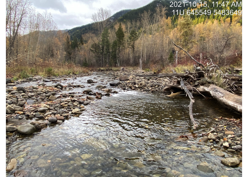
Figure 5.5: Typical habitat upstream of PSCIS crossing 61504.
my_photo2 = pull_photo_by_str(str_to_pull = '_u4_')

my_caption2 = paste0('Typical habitat upstream of PSCIS crossing ', my_site, '.')grid::grid.raster(get_img(photo = my_photo2))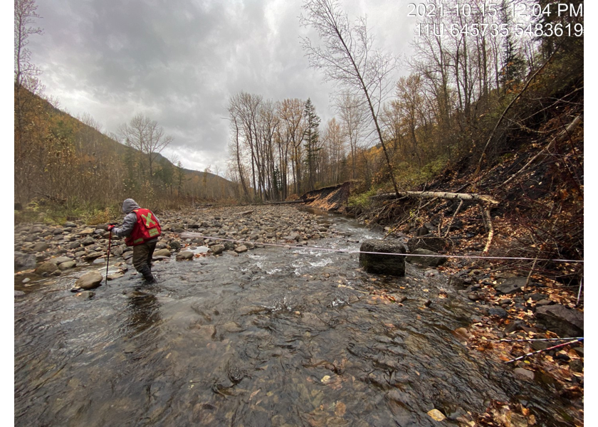
Figure 5.6: Typical habitat upstream of PSCIS crossing 61504.
my_caption <- paste0('Left: ', my_caption1, ' Right: ', my_caption2)

knitr::include_graphics(get_img_path(photo = my_photo1))
knitr::include_graphics("fig/pixel.png")
knitr::include_graphics(get_img_path(photo = my_photo2))
##this is just here so we can clear our environment for tests
knitr::opts_chunk$set(echo=FALSE, message=FALSE, warning=FALSE)
source('R/packages.R')
source('R/functions.R')
source('R/tables.R')my_site <- 62181
my_site2 <- 62182