Appendix - 62505 - Tributary to Lizard Creek
Site Location
PSCIS crossing 62505 is located on a tributary to Lizard Creek 2.5km west of Fernie on Mt. Fernie Park Road. The crossing is located within the Mount Fernie Provincial Park Boundary and approximately 75m upstream from the confluence with Lizard Creek and the responsibility of the Ministry of Environment and Climate Change Strategy. The area is a popular recreational destination for hikers and mountain bikers.
Background
At crossing 62505, tributary to Lizard Creek is a first order stream with a watershed area upstream of the crossing of approximately 0.9km2. The elevation of the south-west facing watershed ranges from a maximum of 1449m to 1048m at the crossing (Table 5.10). Upstream of Mt. Fernie Park Road, no fish have previously been recorded (MoE 2020b). Downstream, Lizard Creek supports westslope cutthroat trout, bull trout, mountain whitefish, brook trout, longnose sucker and longnose dace (MoE 2020a). Elk River Alliance (2020) conducted redd surveys in Lizard Creek in 2019 along with Morrissey Creek, Coal Creek and Forsyth Creek. A total of 55 redds were observed within a 2.4km section of Lizard Creek comprising the largest densities of redds of the four tributaries surveyed (22.9 redds/km).
fpr_tab_wshd_sum(site_id = my_site) %>%
  my_kable(caption_text = paste0('Summary of derived upstream watershed statistics for PSCIS crossing ', my_site, '.'),
footnote_text = 'Elev P60 = Elevation at which 60% of the watershed area is above')| Site | Area Km | Elev Site | Elev Min | Elev Max | Elev Mean | Elev Median | Elev P60 |
|---|---|---|---|---|---|---|---|
| 62505 | 0.9 | 1048 | 1038 | 1449 | 1206 | 1192 | 1168 |
| * Elev P60 = Elevation at which 60% of the watershed area is above |
PSCIS crossing 62505 was prioritized for assessment due to it’s location within provincial park boundaries and the associated positive implications for restoration potential. Although assessed as a low priority for follow up in planning for 2020 field work (Irvine 2021), during 2020 field surveys the site was noted as having a significant sized outlet drop, good flow during the dryest part of the year and a location directly adjacent to Lizard Creek which contains confirmed spawning habitat for westslope cutthrout trout. Table 5.11 presents preliminary fish passage modelling data for crossing 62505 with linear length of habitat <8% upstream estimated at 0.4km and an additional 0.5km of habitat modeled between 8 - 15%. A map of the watershed is provided in map attachment 082G.113.
print_tab_summary_bcfp()| Habitat | Potential | Remediation Gain | Remediation Gain (%) |
|---|---|---|---|
| WCT Spawning (km) | 0.0 | 0.0 | – |
| WCT Rearing (km) | 0.0 | 0.0 | – |
| WCT Stream (km) | 0.9 | 0.5 | 56 |
| WCT Network (km) | 0.9 | 0.5 | 56 |
| WCT Lake Reservoir (ha) | 0.0 | 0.0 | – |
| WCT Wetland (ha) | 0.0 | 0.0 | – |
| WCT Slopeclass03 Waterbodies (km) | 0.0 | 0.0 | – |
| WCT Slopeclass03 (km) | 0.0 | 0.0 | – |
| WCT Slopeclass05 (km) | 0.0 | 0.0 | – |
| WCT Slopeclass08 (km) | 0.4 | 0.0 | 0 |
| WCT Slopeclass15 (km) | 0.5 | 0.5 | 100 |
| WCT Slopeclass22 (km) | 0.0 | 0.0 | – |
| * Model data is preliminary and subject to adjustments. | |||
| † Modelled rearing habitat estimates do not currently include linear lengths of centrelines within lakes and wetlands. |
Stream Characteristics at Crossing
At the time of the survey, the culvert under Mt. Fernie Park Road was un-embedded, non-backwatered and ranked as a barrier to upstream fish passage according to the provincial protocol (MoE 2011b). The pipe was 0.9m in diameter with lengths of 10m, a culvert slope of 5%, a stream width ratio of 3.2 and an outlet drop of 0.25m (Table 5.12). Water temperature was 3\(^\circ\)C, pH was 8 and conductivity was 312uS/cm.
##this is useful to get some comments for the report
hab_site %>% filter(site == my_site & location == 'us') %>% pull(comments)
my_priority <-  my_priority_info()
Stream Characteristics Downstream
The stream was surveyed downstream from the culvert for 75m to the confluence with Lizard Creek (Figures 5.11 - 5.12). Total cover amount was rated as moderate with undercut banks dominant. Cover was also present as small woody debris and overhanging vegetation (Table 5.13). The average channel width was 2.5m and the average gradient was 4.8%. The dominant substrate was gravels with cobbles subdominant. No barriers were noted downstream and there were gravels suitable for spawning westslope cutthroat trout throughout. The habitat was rated as medium value for resident salmonid rearing due to a lack of water.
Stream Characteristics Upstream
The stream was surveyed immediately upstream from 62505 for approximately 700m to ~60m above PSCIS culvert 197863 (Figures 5.13 - 5.14). Immediately above culvert 197863 the stream became very steep with gradients exceeding 20%. Within the area surveyed, total cover amount was rated as moderate with undercut banks dominant. Cover was also present as small woody debris, large woody debris, boulders, deep pools, and overhanging vegetation (Table 5.13). The average channel width was 2.9m, the average wetted width was 1.4m and the average gradient was 7.6%. The dominant substrate was gravels with cobbles subdominant. Occasional pools suitable for juvenile westslope cutthroat trout overwintering and frequent pockets of gravel present suitable for spawning were noted throughout. The fairly steep system had good flow with intermittent small woody debris drops between 0.5 and 1m in height. Habitat value was rated as medium with moderate potential for juvenile salmonid rearing.
Structure Remediation and Cost Estimate
Should restoration/maintenance activities proceed at the site, replacement of PSCIS crossing 62505 with a bridge (12m span) is recommended. The cost of the work is estimated at $240,000 for a cost benefit of 2.8 linear m/$1000 and 8.2m2/$1000.
Conclusion
There was 0.7km of habitat rated as medium value for salmonid rearing upstream of crossing 62505 and below crossing 197863 (where gradients increased to >20%). Mt. Fernie Park Road, at the crossing location, is located within the Mount Fernie Provincial Park Boundary and is the responsibility of the Ministry of Environment and Climate Change Strategy. As the culvert is located approximately 75m upstream from the confluence with Lizard Creek where westslope cutthrout trout spawning is known to occur, remediation of fish passage at the site could reduce the risk that the culvert prevents passage by spawning strays and progeny potentially migrating from areas of the tributary downstream of the culvert as well as from the mainstem of Lizard Creek. Crossing 62505 was ranked as a moderate priority for proceeding to design for replacement.
print_tab_summary()| Location and Stream Data |
|
Crossing Characteristics | – |
|---|---|---|---|
| Date | 2021-10-13 | Crossing Sub Type | Round Culvert |
| PSCIS ID | 62505 | Diameter (m) | 0.9 |
| External ID | – | Length (m) | 10 |
| Crew | AI BK SS | Embedded | No |
| UTM Zone | 11 | Depth Embedded (m) | – |
| Easting | 636941.9 | Resemble Channel | No |
| Northing | 5483777 | Backwatered | No |
| Stream | Tributary to Lizard Creek | Percent Backwatered | – |
| Road | Mt. Fernie Park Road | Fill Depth (m) | 0.3 |
| Road Tenure | Recreation | Outlet Drop (m) | 0.25 |
| Channel Width (m) | 2.9 | Outlet Pool Depth (m) | 0.45 |
| Stream Slope (%) | 7.6 | Inlet Drop | No |
| Beaver Activity | No | Slope (%) | 5 |
| Habitat Value | Medium | Valley Fill | Deep Fill |
| Final score | 31 | Barrier Result | Barrier |
| Fix type | Replace with New Open Bottom Structure | Fix Span / Diameter | 12 |
Photos: From top left clockwise: Road/Site Card, Barrel, Outlet, Downstream, Upstream, Inlet.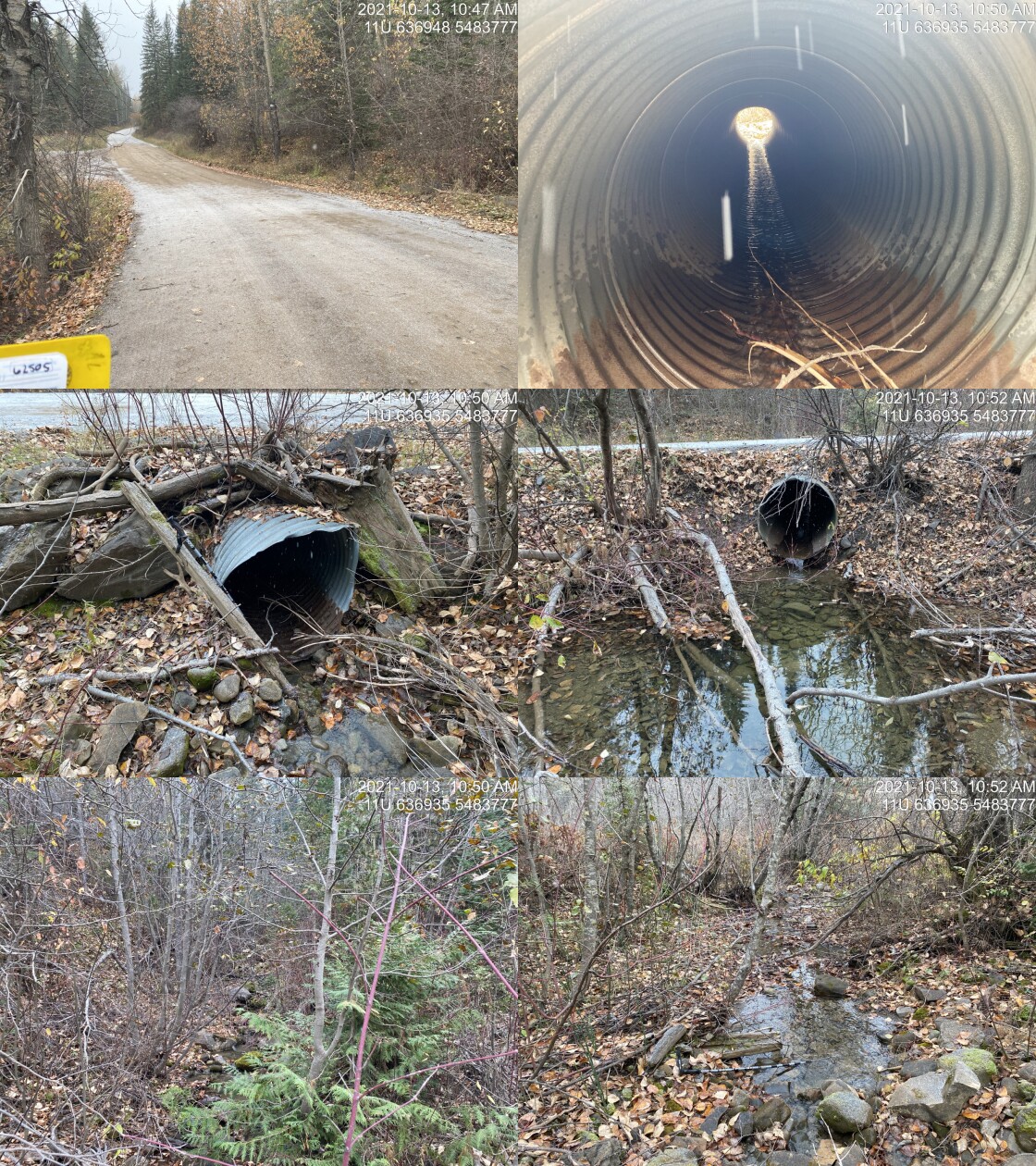
|
|||
| Comments: Very close to Lizard Creek mainstem. 10:43 |
tab_hab_summary %>%
  filter(Site  == my_site) %>%
  # select(-Site) %>%
my_kable(caption_text = paste0('Summary of habitat details for PSCIS crossing ', my_site, '.')) | Site | Location | Length Surveyed (m) | Channel Width (m) | Wetted Width (m) | Pool Depth (m) | Gradient (%) | Total Cover | Habitat Value |
|---|---|---|---|---|---|---|---|---|
| 62505 | Upstream | 700 | 2.9 | 1.4 | 0.3 | 7.6 | moderate | medium |
| 62505 | Downstream | 75 | 2.5 | 1.3 | – | 4.8 | moderate | medium |
my_photo1 = pull_photo_by_str(str_to_pull = '_d1_')

my_caption1 = paste0('Habitat downstream of crossing ', my_site, '.')grid::grid.raster(get_img(photo = my_photo1))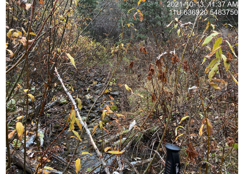
Figure 5.11: Habitat downstream of crossing 62505.
my_photo2 = pull_photo_by_str(str_to_pull = '_d2_')

my_caption2 = paste0('Confluence with Lizard Creek located ~70m downstream of crossing ', my_site, '.')grid::grid.raster(get_img(photo = my_photo2))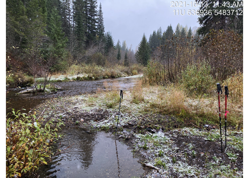
Figure 5.12: Confluence with Lizard Creek located ~70m downstream of crossing 62505.
my_caption <- paste0('Left: ', my_caption1, ' Right: ', my_caption2)

knitr::include_graphics(get_img_path(photo = my_photo1))
knitr::include_graphics("fig/pixel.png")
knitr::include_graphics(get_img_path(photo = my_photo2))
my_photo1 = pull_photo_by_str(str_to_pull = '_u1_')
my_caption1 = paste0('Habitat upstream of PSCIS crossing ', my_site, '.')grid::grid.raster(get_img(photo = my_photo1))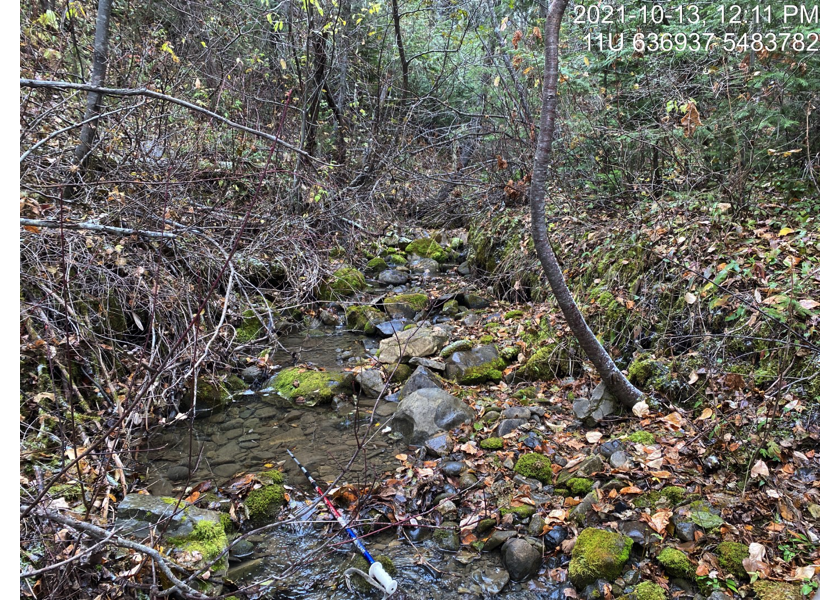
Figure 5.13: Habitat upstream of PSCIS crossing 62505.
my_photo2 = pull_photo_by_str(str_to_pull = '_u2_')

my_caption2 = paste0('Habitat upstream of PSCIS crossing ', my_site, '.')grid::grid.raster(get_img(photo = my_photo2))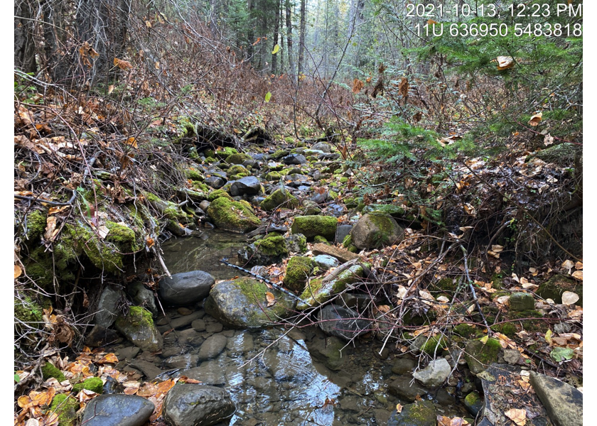
Figure 5.14: Habitat upstream of PSCIS crossing 62505.
my_caption <- paste0('Left: ', my_caption1, ' Right: ', my_caption2)

knitr::include_graphics(get_img_path(photo = my_photo1))
knitr::include_graphics("fig/pixel.png")
knitr::include_graphics(get_img_path(photo = my_photo2))
##this is just here so we can clear our environment for tests
knitr::opts_chunk$set(echo=FALSE, message=FALSE, warning=FALSE)
source('R/packages.R')
source('R/functions.R')
source('R/tables.R')my_site <- 197787
my_site2 <- 197786