Appendix - Phase 1 Fish Passage Assessment Data and Photos
| Location and Stream Data |
|
Crossing Characteristics | – |
|---|---|---|---|
| Date | 2023-08-30 | Crossing Sub Type | Round Culvert |
| PSCIS ID | 6539 | Diameter (m) | 3.1 |
| External ID | – | Length (m) | 16 |
| Crew | AI TS JD BP | Embedded | No |
| UTM Zone | 10 | Depth Embedded (m) | – |
| Easting | 489924.3 | Resemble Channel | No |
| Northing | 6077196 | Backwatered | Yes |
| Stream | Hammett Creek | Percent Backwatered | 100 |
| Road | Carp Lake FSR | Fill Depth (m) | 0.3 |
| Road Tenure | Canfor R01860 | Outlet Drop (m) | 0 |
| Channel Width (m) | 4.5 | Outlet Pool Depth (m) | 0.7 |
| Stream Slope (%) | 2 | Inlet Drop | Yes |
| Beaver Activity | Yes | Slope (%) | 1 |
| Habitat Value | High | Valley Fill | Deep Fill |
| Final score | 24 | Barrier Result | Barrier |
| Fix type | Replace with New Open Bottom Structure | Fix Span / Diameter | 15 |
Photos: PSCIS ID 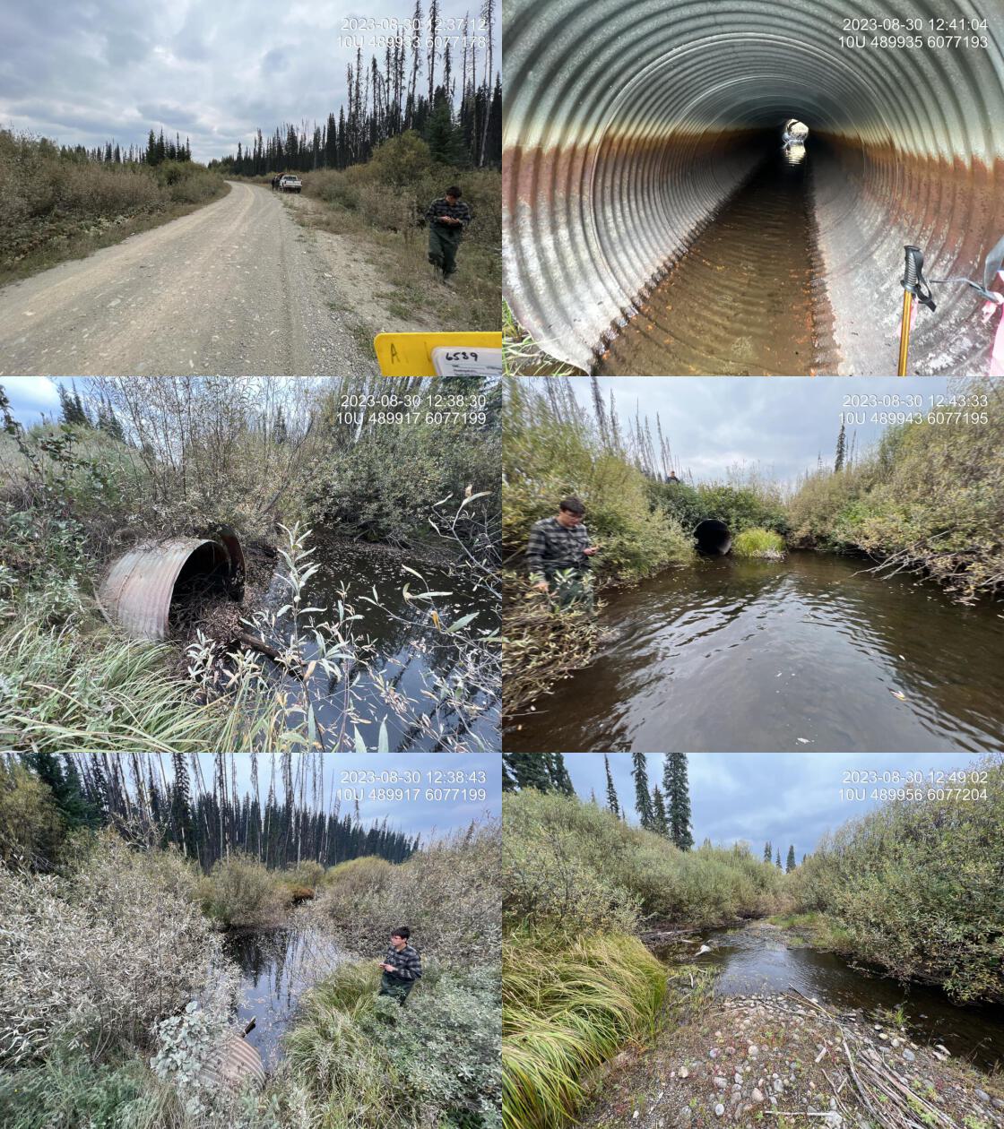 . From top left clockwise: Road/Site Card, Barrel, Outlet, Downstream, Upstream, Inlet.6539 . From top left clockwise: Road/Site Card, Barrel, Outlet, Downstream, Upstream, Inlet.6539
|
|||
| Comments: Public, beaver influenced wet land upstream. Fish observed at outlet. Nice flowing system downstream with pockets of gravel throughout. Two pipes at 1.55 m each. Beaver grate outlet cage dislodged and within stream approximately 5 m downstream of the pipes. 12:35:14 |
| Location and Stream Data |
|
Crossing Characteristics | – |
|---|---|---|---|
| Date | 2023-08-30 | Crossing Sub Type | Round Culvert |
| PSCIS ID | 6541 | Diameter (m) | 1.2 |
| External ID | – | Length (m) | 21 |
| Crew | AI JD BP TS | Embedded | No |
| UTM Zone | 10 | Depth Embedded (m) | – |
| Easting | 487842.4 | Resemble Channel | No |
| Northing | 6079435 | Backwatered | No |
| Stream | Hammett Creek | Percent Backwatered | – |
| Road | Spur | Fill Depth (m) | 2 |
| Road Tenure | Canfor R07645 | Outlet Drop (m) | 0.2 |
| Channel Width (m) | 3.8 | Outlet Pool Depth (m) | 0.7 |
| Stream Slope (%) | 2.5 | Inlet Drop | No |
| Beaver Activity | No | Slope (%) | 3 |
| Habitat Value | Medium | Valley Fill | Deep Fill |
| Final score | 34 | Barrier Result | Barrier |
| Fix type | Replace with New Open Bottom Structure | Fix Span / Diameter | 15 |
Photos: PSCIS ID 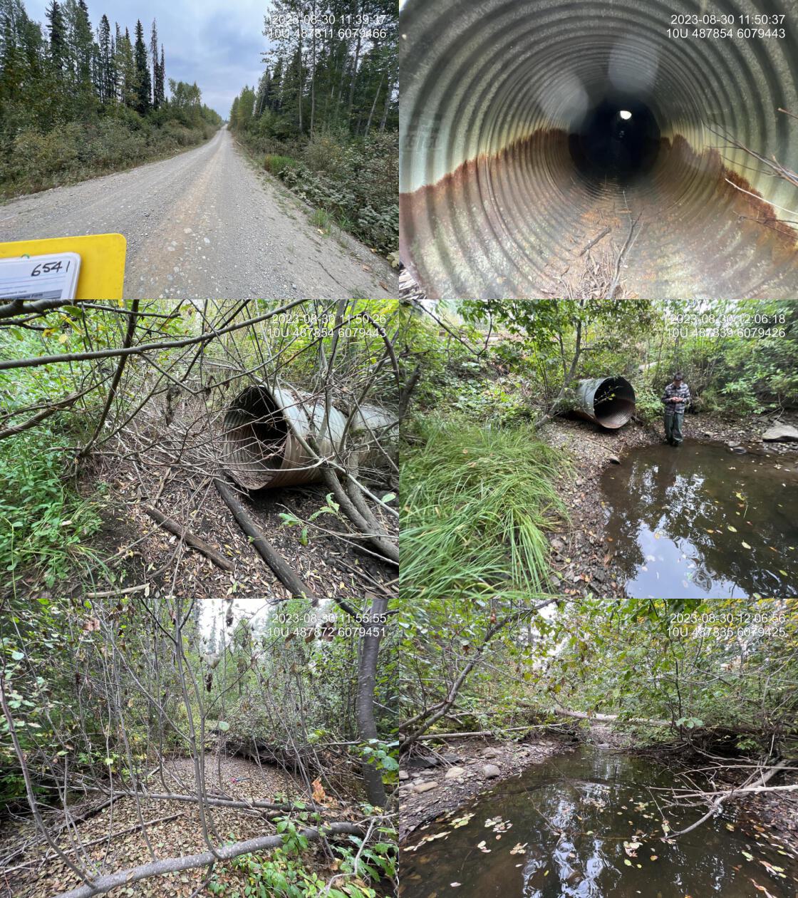 . From top left clockwise: Road/Site Card, Barrel, Outlet, Downstream, Upstream, Inlet.6541 . From top left clockwise: Road/Site Card, Barrel, Outlet, Downstream, Upstream, Inlet.6541
|
|||
| Comments: Dry channel upstream and downstream except for fairly deep outlet pool with fish present. Culvert in poor shape with lots of rust. Road embankment fill failing on downstream side of road with large hole. Nice gravels available for spawning. Although outlet drop appears to be greater than 50 cm, it was actually estimated at 20 cm because the outlet pool has the water below the level of the stream bed on the downstream side. 11:40:56 |
| Location and Stream Data |
|
Crossing Characteristics | – |
|---|---|---|---|
| Date | 2023-08-30 | Crossing Sub Type | Round Culvert |
| PSCIS ID | 6543 | Diameter (m) | 4 |
| External ID | – | Length (m) | 21 |
| Crew | AI | Embedded | No |
| UTM Zone | 10 | Depth Embedded (m) | – |
| Easting | 496138.3 | Resemble Channel | No |
| Northing | 6071030 | Backwatered | No |
| Stream | Tributary to Hammett Creek | Percent Backwatered | – |
| Road | Davie-War FSR | Fill Depth (m) | 0.5 |
| Road Tenure | Canfor R01860 | Outlet Drop (m) | 0.3 |
| Channel Width (m) | 4.7 | Outlet Pool Depth (m) | 1.2 |
| Stream Slope (%) | 1 | Inlet Drop | Yes |
| Beaver Activity | Yes | Slope (%) | 0.5 |
| Habitat Value | High | Valley Fill | Deep Fill |
| Final score | 26 | Barrier Result | Barrier |
| Fix type | Replace with New Open Bottom Structure | Fix Span / Diameter | 15 |
Photos: PSCIS ID 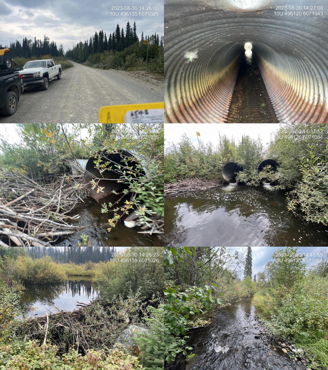 . From top left clockwise: Road/Site Card, Barrel, Outlet, Downstream, Upstream, Inlet.6543 . From top left clockwise: Road/Site Card, Barrel, Outlet, Downstream, Upstream, Inlet.6543
|
|||
| Comments: Large system with lots of water. 1.3 m high beaverdam 2 m above inlets. Two pipes at 2.0 m in size each. Beaver cage on west pipe inlet functioning to keep dam away from the actual inlet. Abundant gravel suitable for spawning downstream. Very nice stream and potential good candidate for replacement with a Bridge. 14:25:01 |
| Location and Stream Data |
|
Crossing Characteristics | – |
|---|---|---|---|
| Date | 2023-08-30 | Crossing Sub Type | Round Culvert |
| PSCIS ID | 6544 | Diameter (m) | 0.5 |
| External ID | – | Length (m) | 8 |
| Crew | MW MD | Embedded | No |
| UTM Zone | 10 | Depth Embedded (m) | – |
| Easting | 506941 | Resemble Channel | No |
| Northing | 6075745 | Backwatered | Yes |
| Stream | Tributary to Crooked River | Percent Backwatered | 100 |
| Road | Carp Lake FSR | Fill Depth (m) | 0.3 |
| Road Tenure | MOF 7731 | Outlet Drop (m) | 0 |
| Channel Width (m) | 2.7 | Outlet Pool Depth (m) | 0 |
| Stream Slope (%) | 1 | Inlet Drop | No |
| Beaver Activity | Yes | Slope (%) | 1 |
| Habitat Value | Low | Valley Fill | Deep Fill |
| Final score | 21 | Barrier Result | Barrier |
| Fix type | Replace with New Open Bottom Structure | Fix Span / Diameter | 15 |
Photos: PSCIS ID 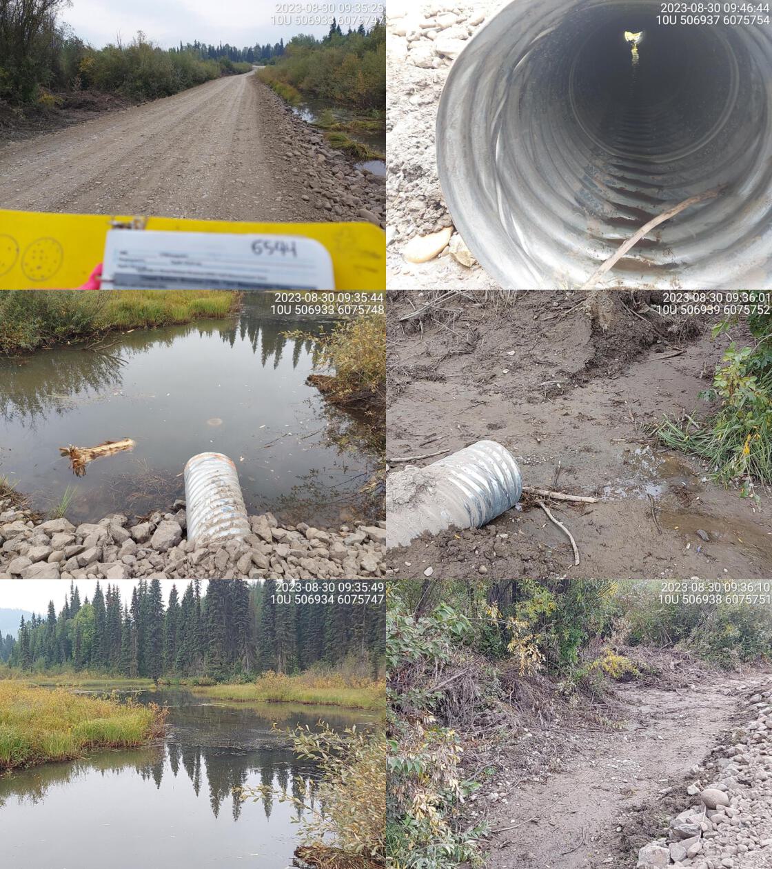 . From top left clockwise: Road/Site Card, Barrel, Outlet, Downstream, Upstream, Inlet.6544 . From top left clockwise: Road/Site Card, Barrel, Outlet, Downstream, Upstream, Inlet.6544
|
|||
| Comments: Beaver activity at inlet side. Wetland upstream. Pipe is very small. Pipe is caved in near the inlet. Dewatered downstream. 09:32:45 |
| Location and Stream Data |
|
Crossing Characteristics | – |
|---|---|---|---|
| Date | 2023-08-30 | Crossing Sub Type | Round Culvert |
| PSCIS ID | 6546 | Diameter (m) | 0.9 |
| External ID | – | Length (m) | 16 |
| Crew | AI BP TS JD | Embedded | No |
| UTM Zone | 10 | Depth Embedded (m) | – |
| Easting | 499191.5 | Resemble Channel | No |
| Northing | 6069209 | Backwatered | Yes |
| Stream | Tributary to Weedon Creek | Percent Backwatered | 100 |
| Road | Davie-War FSR | Fill Depth (m) | 2 |
| Road Tenure | Canfor R01860 | Outlet Drop (m) | 0 |
| Channel Width (m) | 8 | Outlet Pool Depth (m) | 0.65 |
| Stream Slope (%) | 0 | Inlet Drop | No |
| Beaver Activity | Yes | Slope (%) | 1.8 |
| Habitat Value | Medium | Valley Fill | Deep Fill |
| Final score | 24 | Barrier Result | Barrier |
| Fix type | Replace with New Open Bottom Structure | Fix Span / Diameter | 18 |
Photos: PSCIS ID 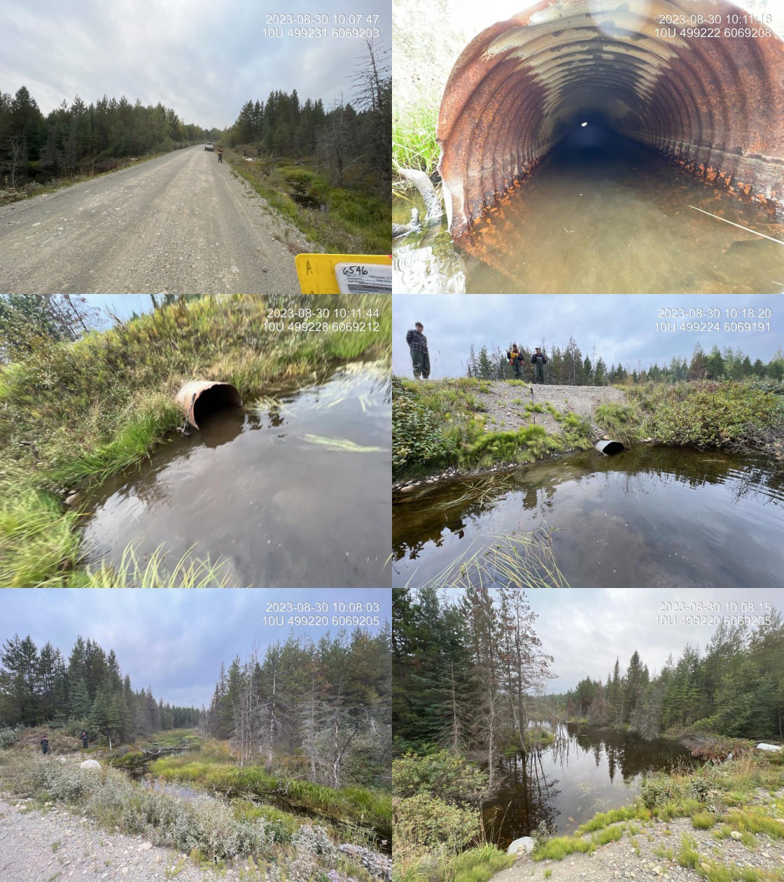 . From top left clockwise: Road/Site Card, Barrel, Outlet, Downstream, Upstream, Inlet.6546 . From top left clockwise: Road/Site Card, Barrel, Outlet, Downstream, Upstream, Inlet.6546
|
|||
| Comments: Historic assessment from 2006 may not have measured the lowest elevation pipe. There are three pipes here. The main functioning pipe is 0.9 diameter and its 100% backwatered on the east side of the two larger 1.5 m pipes. Wetland, beaver influenced habitat, both upstream and downstream. Numerous fish (some RB) observed downstream and upstream. 10:03:49 |
| Location and Stream Data |
|
Crossing Characteristics | – |
|---|---|---|---|
| Date | 2023-08-30 | Crossing Sub Type | Round Culvert |
| PSCIS ID | 6621 | Diameter (m) | 4.1 |
| External ID | – | Length (m) | 28 |
| Crew | MW MD | Embedded | No |
| UTM Zone | 10 | Depth Embedded (m) | – |
| Easting | 500201.1 | Resemble Channel | No |
| Northing | 6067481 | Backwatered | Yes |
| Stream | Tributary to Weedon Creek | Percent Backwatered | 100 |
| Road | Davie-War FSR | Fill Depth (m) | 2.5 |
| Road Tenure | Canfor R01860 | Outlet Drop (m) | 0 |
| Channel Width (m) | 5.6 | Outlet Pool Depth (m) | 1.3 |
| Stream Slope (%) | 1.5 | Inlet Drop | No |
| Beaver Activity | Yes | Slope (%) | 1 |
| Habitat Value | Medium | Valley Fill | Deep Fill |
| Final score | 24 | Barrier Result | Barrier |
| Fix type | Replace with New Open Bottom Structure | Fix Span / Diameter | 15 |
Photos: PSCIS ID 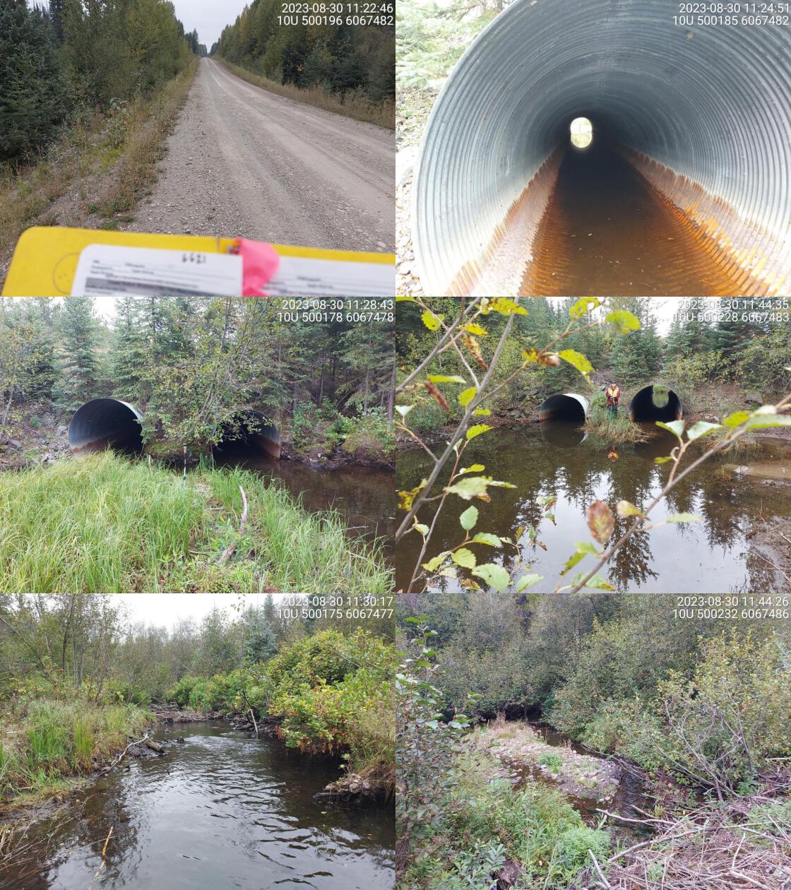 . From top left clockwise: Road/Site Card, Barrel, Outlet, Downstream, Upstream, Inlet.6621 . From top left clockwise: Road/Site Card, Barrel, Outlet, Downstream, Upstream, Inlet.6621
|
|||
| Comments: Two pipes of similar diameter. Fully backwatered at outlet. Clear evidence of beaver activity near crossing. Dams upstream and downstream of crossing, creating big outlet pool. Fish spotted in culvert. 11:19:18 |
| Location and Stream Data |
|
Crossing Characteristics | – |
|---|---|---|---|
| Date | 2023-08-30 | Crossing Sub Type | Round Culvert |
| PSCIS ID | 6622 | Diameter (m) | 3.5 |
| External ID | – | Length (m) | 18 |
| Crew | MW MD | Embedded | No |
| UTM Zone | 10 | Depth Embedded (m) | – |
| Easting | 498186 | Resemble Channel | No |
| Northing | 6061320 | Backwatered | No |
| Stream | Tributary to Weedon Creek | Percent Backwatered | – |
| Road | Davie-Weedon Lake FSR | Fill Depth (m) | 1 |
| Road Tenure | MOF 7719 | Outlet Drop (m) | 0 |
| Channel Width (m) | 2.5 | Outlet Pool Depth (m) | 0.4 |
| Stream Slope (%) | 2.5 | Inlet Drop | No |
| Beaver Activity | No | Slope (%) | 3 |
| Habitat Value | High | Valley Fill | Deep Fill |
| Final score | 23 | Barrier Result | Barrier |
| Fix type | Replace with New Open Bottom Structure | Fix Span / Diameter | 15 |
Photos: PSCIS ID 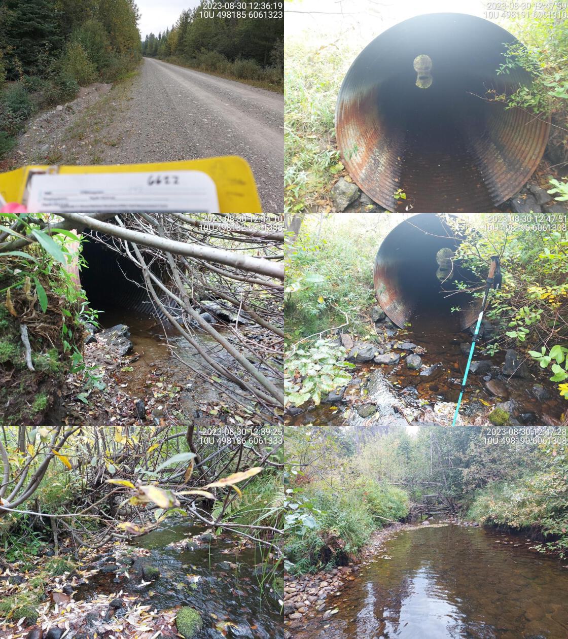 . From top left clockwise: Road/Site Card, Barrel, Outlet, Downstream, Upstream, Inlet.6622 . From top left clockwise: Road/Site Card, Barrel, Outlet, Downstream, Upstream, Inlet.6622
|
|||
| Comments: Two pipes of equal width. High habitat value, good flowing stream. 12:33:15 |
| Location and Stream Data |
|
Crossing Characteristics | – |
|---|---|---|---|
| Date | 2023-08-30 | Crossing Sub Type | Round Culvert |
| PSCIS ID | 6623 | Diameter (m) | 1.6 |
| External ID | – | Length (m) | 25 |
| Crew | MW MD | Embedded | No |
| UTM Zone | 10 | Depth Embedded (m) | – |
| Easting | 495931.2 | Resemble Channel | No |
| Northing | 6058430 | Backwatered | No |
| Stream | Tributary to Weedon Lake | Percent Backwatered | – |
| Road | Davie-Weedon Lake FSR | Fill Depth (m) | 1 |
| Road Tenure | MOF 7719 | Outlet Drop (m) | 0.3 |
| Channel Width (m) | 2.6 | Outlet Pool Depth (m) | 0.7 |
| Stream Slope (%) | 1 | Inlet Drop | No |
| Beaver Activity | No | Slope (%) | 1.5 |
| Habitat Value | Medium | Valley Fill | Deep Fill |
| Final score | 34 | Barrier Result | Barrier |
| Fix type | Replace with New Open Bottom Structure | Fix Span / Diameter | 15 |
Photos: PSCIS ID 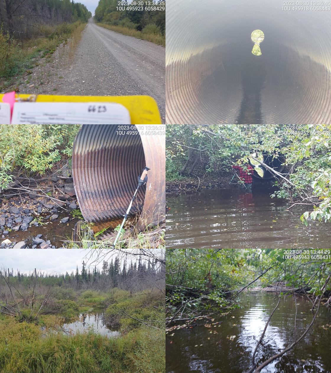 . From top left clockwise: Road/Site Card, Barrel, Outlet, Downstream, Upstream, Inlet.6623 . From top left clockwise: Road/Site Card, Barrel, Outlet, Downstream, Upstream, Inlet.6623
|
|||
| Comments: Big pipe, backwatered and creating big outlet pool. Wetland upstream. Some flow downstream. 13:33:37 |
| Location and Stream Data |
|
Crossing Characteristics | – |
|---|---|---|---|
| Date | 2023-08-30 | Crossing Sub Type | Round Culvert |
| PSCIS ID | 6624 | Diameter (m) | 2.2 |
| External ID | – | Length (m) | 29 |
| Crew | MW TS JD BP | Embedded | Yes |
| UTM Zone | 10 | Depth Embedded (m) | 1.5 |
| Easting | 495267.5 | Resemble Channel | No |
| Northing | 6053873 | Backwatered | Yes |
| Stream | Tributary to Weedon Lake | Percent Backwatered | 100 |
| Road | Davie-Weedon Lake FSR | Fill Depth (m) | 1 |
| Road Tenure | Winton R02864 | Outlet Drop (m) | 0 |
| Channel Width (m) | 3.8 | Outlet Pool Depth (m) | 1.8 |
| Stream Slope (%) | 1 | Inlet Drop | No |
| Beaver Activity | Yes | Slope (%) | 2 |
| Habitat Value | Low | Valley Fill | Deep Fill |
| Final score | 14 | Barrier Result | Passable |
| Fix type | – | Fix Span / Diameter | – |
Photos: PSCIS ID 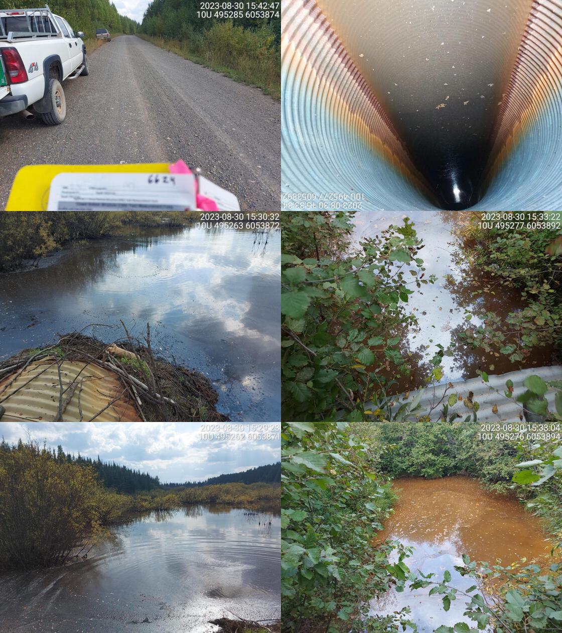 . From top left clockwise: Road/Site Card, Barrel, Outlet, Downstream, Upstream, Inlet.6624 . From top left clockwise: Road/Site Card, Barrel, Outlet, Downstream, Upstream, Inlet.6624
|
|||
| Comments: Big flooded wetland area. Beaver dam blocking inlet side. Massive outlet pool. Stream width and slope estimated. No defined channel. Culvert almost fully submerged on inlet side. 15:27:49 |
| Location and Stream Data |
|
Crossing Characteristics | – |
|---|---|---|---|
| Date | 2023-09-02 | Crossing Sub Type | Bridge |
| PSCIS ID | 57621 | Diameter (m) | 11 |
| External ID | – | Length (m) | 4 |
| Crew | MW | Embedded | – |
| UTM Zone | 10 | Depth Embedded (m) | – |
| Easting | 526546.9 | Resemble Channel | – |
| Northing | 6057752 | Backwatered | – |
| Stream | Tributary to Tacheeda Lakes | Percent Backwatered | – |
| Road | Chuchinka-Hambone FSR | Fill Depth (m) | – |
| Road Tenure | MOF 5506 | Outlet Drop (m) | – |
| Channel Width (m) | – | Outlet Pool Depth (m) | – |
| Stream Slope (%) | – | Inlet Drop | – |
| Beaver Activity | No | Slope (%) | – |
| Habitat Value | – | Valley Fill | – |
| Final score | 0 | Barrier Result | Passable |
| Fix type | – | Fix Span / Diameter | – |
Photos: PSCIS ID 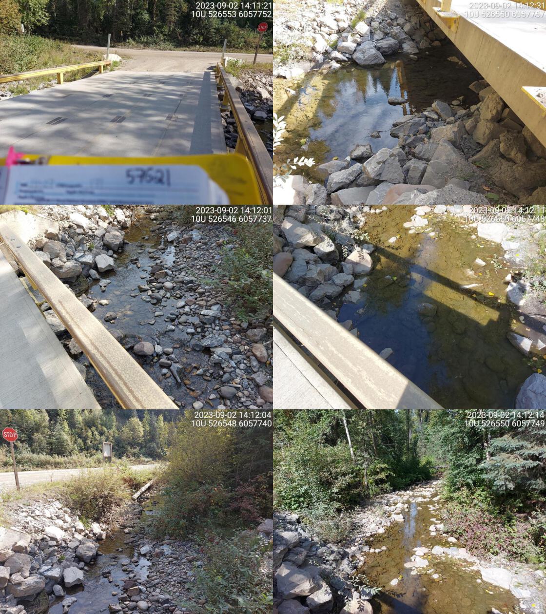 . From top left clockwise: Road/Site Card, Barrel, Outlet, Downstream, Upstream, Inlet.57621 . From top left clockwise: Road/Site Card, Barrel, Outlet, Downstream, Upstream, Inlet.57621
|
|||
| Comments: Near intersection of hambone and colbourne. Wide channel with good flow. 14:09:47 |
| Location and Stream Data |
|
Crossing Characteristics | – |
|---|---|---|---|
| Date | 2023-08-25 | Crossing Sub Type | Round Culvert |
| PSCIS ID | 198660 | Diameter (m) | 1.18 |
| External ID | 3700002 | Length (m) | 22 |
| Crew | MW | Embedded | No |
| UTM Zone | 10 | Depth Embedded (m) | – |
| Easting | 519645.9 | Resemble Channel | No |
| Northing | 6041053 | Backwatered | No |
| Stream | Copper Creek | Percent Backwatered | – |
| Road | Highway 97 | Fill Depth (m) | 1.2 |
| Road Tenure | MOTI | Outlet Drop (m) | 0.4 |
| Channel Width (m) | 3.7 | Outlet Pool Depth (m) | 0.6 |
| Stream Slope (%) | 2 | Inlet Drop | No |
| Beaver Activity | No | Slope (%) | 2.5 |
| Habitat Value | Medium | Valley Fill | Deep Fill |
| Final score | 34 | Barrier Result | Barrier |
| Fix type | Replace with New Open Bottom Structure | Fix Span / Diameter | 14 |
Photos: PSCIS ID 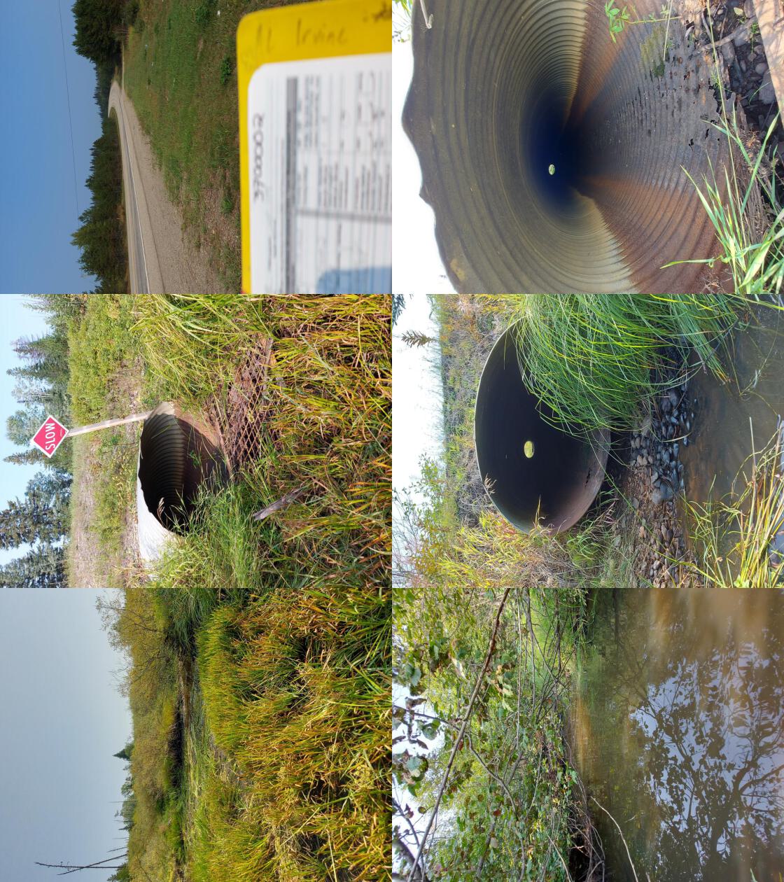 . From top left clockwise: Road/Site Card, Barrel, Outlet, Downstream, Upstream, Inlet.3700002 . From top left clockwise: Road/Site Card, Barrel, Outlet, Downstream, Upstream, Inlet.3700002
|
|||
| Comments: No water in culvert. Some water near inlet and outlet. Stream dewaters downstream again after ~20m. Burbot have been caught in the past approximately 700m upstream of the highway. Wide channel with small lakes and ponds upstream. Ministry of Transportation chris_culvert_id: 1997081. 11:52:21 |
| Location and Stream Data |
|
Crossing Characteristics | – |
|---|---|---|---|
| Date | 2023-08-25 | Crossing Sub Type | Round Culvert |
| PSCIS ID | 198661 | Diameter (m) | 0.7 |
| External ID | 3700034 | Length (m) | 20 |
| Crew | MW | Embedded | Yes |
| UTM Zone | 10 | Depth Embedded (m) | 0.37 |
| Easting | 518793.7 | Resemble Channel | Yes |
| Northing | 6049041 | Backwatered | Yes |
| Stream | Tributary to Crooked River | Percent Backwatered | 100 |
| Road | Highway 97 | Fill Depth (m) | 0.5 |
| Road Tenure | MOTI | Outlet Drop (m) | 0 |
| Channel Width (m) | 3.1 | Outlet Pool Depth (m) | 0.5 |
| Stream Slope (%) | 2 | Inlet Drop | No |
| Beaver Activity | No | Slope (%) | 1 |
| Habitat Value | Low | Valley Fill | Deep Fill |
| Final score | 14 | Barrier Result | Passable |
| Fix type | – | Fix Span / Diameter | – |
Photos: PSCIS ID 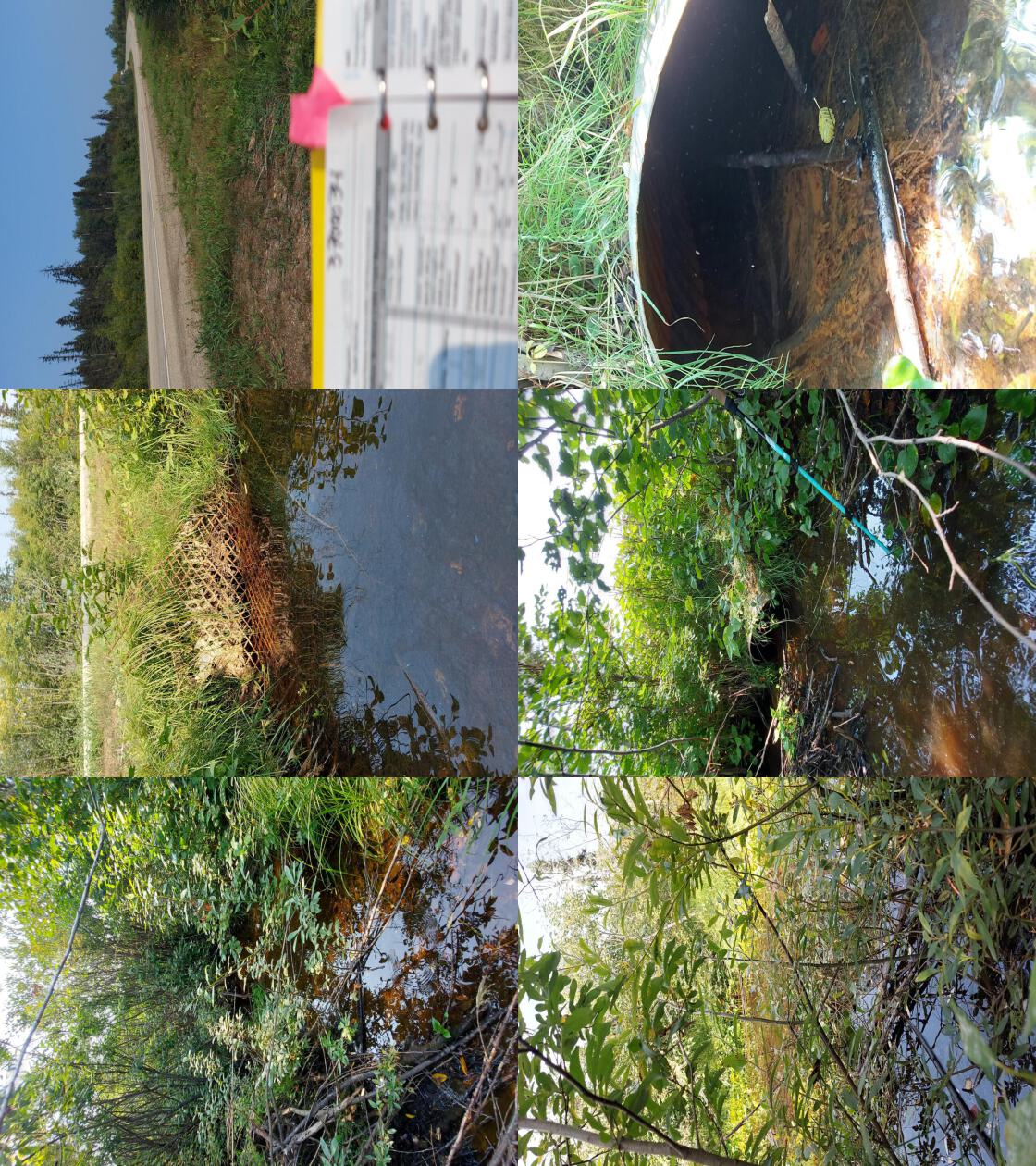 . From top left clockwise: Road/Site Card, Barrel, Outlet, Downstream, Upstream, Inlet.3700034 . From top left clockwise: Road/Site Card, Barrel, Outlet, Downstream, Upstream, Inlet.3700034
|
|||
| Comments: Grate on inlet. Backwatered and big wetland area upstream. Difficult to determine where stream is, width and gradient estimated. Ministry of Transportation chris_culvert_id: 1997003. 12:41:10 |
| Location and Stream Data |
|
Crossing Characteristics | – |
|---|---|---|---|
| Date | 2023-08-25 | Crossing Sub Type | Round Culvert |
| PSCIS ID | 198662 | Diameter (m) | 3.5 |
| External ID | 3700010 | Length (m) | 25 |
| Crew | MW | Embedded | Yes |
| UTM Zone | 10 | Depth Embedded (m) | 0.6 |
| Easting | 519126.1 | Resemble Channel | Yes |
| Northing | 6053247 | Backwatered | Yes |
| Stream | Redrocky Creek | Percent Backwatered | 100 |
| Road | Highway 97 | Fill Depth (m) | 2.5 |
| Road Tenure | MOTI | Outlet Drop (m) | 0 |
| Channel Width (m) | 5.2 | Outlet Pool Depth (m) | 4 |
| Stream Slope (%) | 1 | Inlet Drop | No |
| Beaver Activity | Yes | Slope (%) | 1 |
| Habitat Value | Medium | Valley Fill | Deep Fill |
| Final score | 19 | Barrier Result | Potential |
| Fix type | Replace with New Open Bottom Structure | Fix Span / Diameter | 14 |
Photos: PSCIS ID 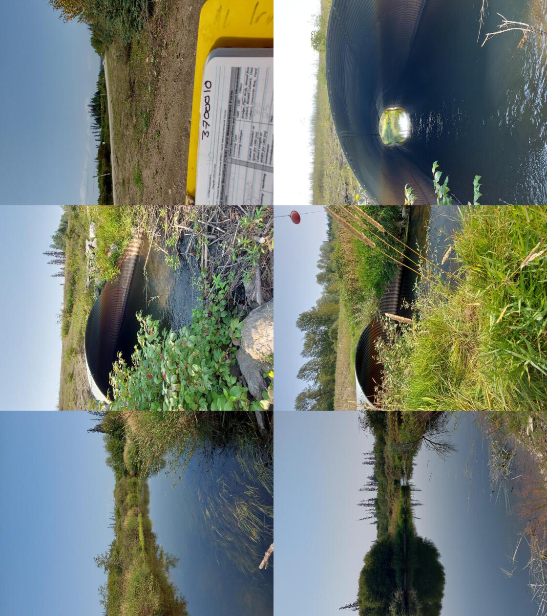 . From top left clockwise: Road/Site Card, Barrel, Outlet, Downstream, Upstream, Inlet.3700010 . From top left clockwise: Road/Site Card, Barrel, Outlet, Downstream, Upstream, Inlet.3700010
|
|||
| Comments: Enormous outlet pool indicating culvert may be undersized. Numerous fish spotted in outlet pool and inlet side. Debris jams covering entire stream channel at inlet and at outlet of outlet pool. Pool very deep, depth estimated. Ministry of Transportation chris_hwy_structure_road_id: 3759. 13:35:05 |
| Location and Stream Data |
|
Crossing Characteristics | – |
|---|---|---|---|
| Date | 2023-08-25 | Crossing Sub Type | Round Culvert |
| PSCIS ID | 198663 | Diameter (m) | 0.6 |
| External ID | 3700015 | Length (m) | 22 |
| Crew | MW | Embedded | No |
| UTM Zone | 10 | Depth Embedded (m) | – |
| Easting | 517177.1 | Resemble Channel | No |
| Northing | 6054490 | Backwatered | No |
| Stream | Tributary to Crooked River | Percent Backwatered | – |
| Road | Highway 97 | Fill Depth (m) | 2.5 |
| Road Tenure | MOTI | Outlet Drop (m) | 0.3 |
| Channel Width (m) | 1.1 | Outlet Pool Depth (m) | 0.1 |
| Stream Slope (%) | 4 | Inlet Drop | No |
| Beaver Activity | No | Slope (%) | 3 |
| Habitat Value | Low | Valley Fill | Deep Fill |
| Final score | 39 | Barrier Result | Barrier |
| Fix type | Replace Structure with Streambed Simulation CBS | Fix Span / Diameter | 3 |
Photos: PSCIS ID 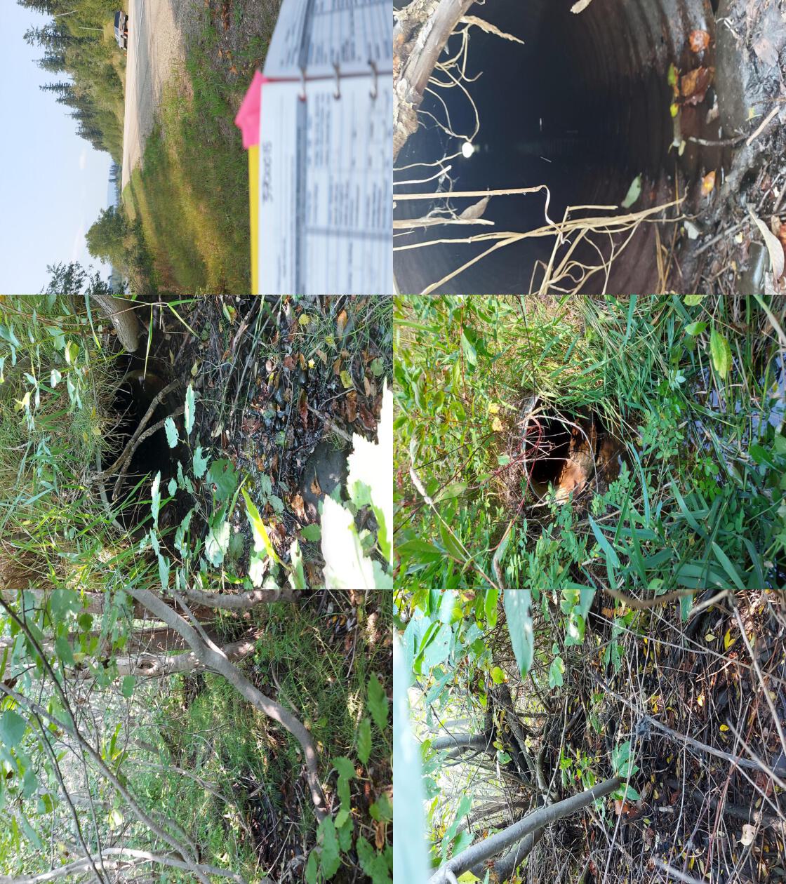 . From top left clockwise: Road/Site Card, Barrel, Outlet, Downstream, Upstream, Inlet.3700015 . From top left clockwise: Road/Site Card, Barrel, Outlet, Downstream, Upstream, Inlet.3700015
|
|||
| Comments: Very little flow through culvert. Overgrown channel. Very little water in stream. Not likely fish bearing. Ministry of Transportation chris_culvert_id: 1996752. 14:05:09 |
| Location and Stream Data |
|
Crossing Characteristics | – |
|---|---|---|---|
| Date | 2023-08-25 | Crossing Sub Type | Oval Culvert |
| PSCIS ID | 198664 | Diameter (m) | 4.2 |
| External ID | 3701558 | Length (m) | 26 |
| Crew | MW | Embedded | No |
| UTM Zone | 10 | Depth Embedded (m) | – |
| Easting | 513139.9 | Resemble Channel | No |
| Northing | 6067043 | Backwatered | No |
| Stream | Altezega Creek | Percent Backwatered | – |
| Road | Highway 97 | Fill Depth (m) | 1.5 |
| Road Tenure | MOTI | Outlet Drop (m) | 0.3 |
| Channel Width (m) | 3.5 | Outlet Pool Depth (m) | 0.4 |
| Stream Slope (%) | 1 | Inlet Drop | No |
| Beaver Activity | No | Slope (%) | 0 |
| Habitat Value | High | Valley Fill | Deep Fill |
| Final score | 23 | Barrier Result | Barrier |
| Fix type | Replace with New Open Bottom Structure | Fix Span / Diameter | 14 |
Photos: PSCIS ID 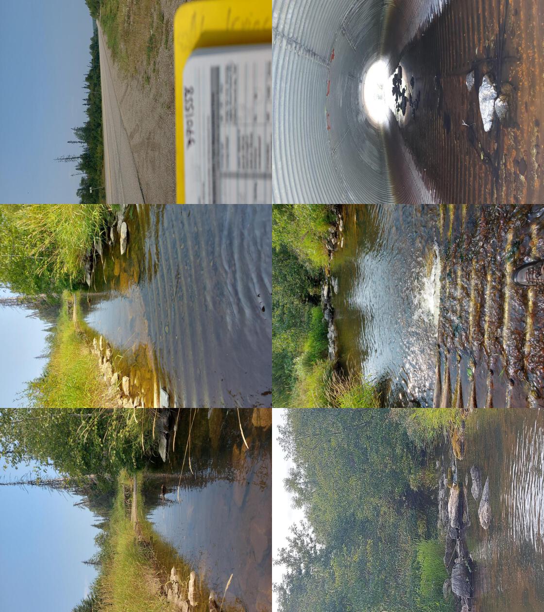 . From top left clockwise: Road/Site Card, Barrel, Outlet, Downstream, Upstream, Inlet.3701558 . From top left clockwise: Road/Site Card, Barrel, Outlet, Downstream, Upstream, Inlet.3701558
|
|||
| Comments: Fish spotted in culvert and near inlet. Some substrate and cobbles in pipe. Ministry of Transportation chris_hwy_structure_road_id: 2434. 14:47:11 |
| Location and Stream Data |
|
Crossing Characteristics | – |
|---|---|---|---|
| Date | 2023-08-25 | Crossing Sub Type | Ford |
| PSCIS ID | 198665 | Diameter (m) | – |
| External ID | 3702598 | Length (m) | – |
| Crew | MW | Embedded | – |
| UTM Zone | 10 | Depth Embedded (m) | – |
| Easting | 513534.5 | Resemble Channel | – |
| Northing | 6067128 | Backwatered | – |
| Stream | Altezega Creek | Percent Backwatered | – |
| Road | Unknown | Fill Depth (m) | – |
| Road Tenure | Unclassified | Outlet Drop (m) | – |
| Channel Width (m) | – | Outlet Pool Depth (m) | – |
| Stream Slope (%) | – | Inlet Drop | – |
| Beaver Activity | No | Slope (%) | – |
| Habitat Value | – | Valley Fill | – |
| Final score | 0 | Barrier Result | Unknown |
| Fix type | – | Fix Span / Diameter | – |
Photos: PSCIS ID 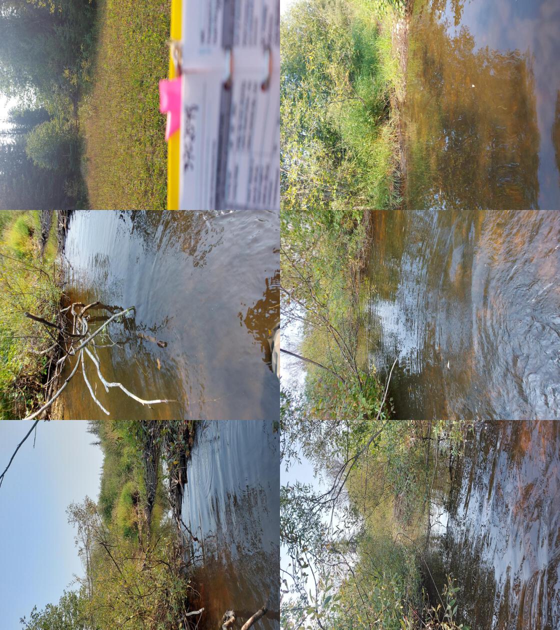 . From top left clockwise: Road/Site Card, Barrel, Outlet, Downstream, Upstream, Inlet.3702598 . From top left clockwise: Road/Site Card, Barrel, Outlet, Downstream, Upstream, Inlet.3702598
|
|||
| Comments: High habitat quality. Old quad trail. Small trib flowing into creek from one side. 15:08:17 |
| Location and Stream Data |
|
Crossing Characteristics | – |
|---|---|---|---|
| Date | 2023-08-25 | Crossing Sub Type | Round Culvert |
| PSCIS ID | 198666 | Diameter (m) | 1.2 |
| External ID | 2200002 | Length (m) | 60 |
| Crew | AI | Embedded | No |
| UTM Zone | 10 | Depth Embedded (m) | – |
| Easting | 497880.6 | Resemble Channel | No |
| Northing | 6093710 | Backwatered | No |
| Stream | Tributary to McLeod lake | Percent Backwatered | – |
| Road | Highway 97 | Fill Depth (m) | 9 |
| Road Tenure | MOTI | Outlet Drop (m) | 0.65 |
| Channel Width (m) | 3 | Outlet Pool Depth (m) | 1 |
| Stream Slope (%) | 0.5 | Inlet Drop | No |
| Beaver Activity | No | Slope (%) | 0.5 |
| Habitat Value | Medium | Valley Fill | Deep Fill |
| Final score | 32 | Barrier Result | Barrier |
| Fix type | Replace Structure with Streambed Simulation CBS | Fix Span / Diameter | 4.5 |
Photos: PSCIS ID 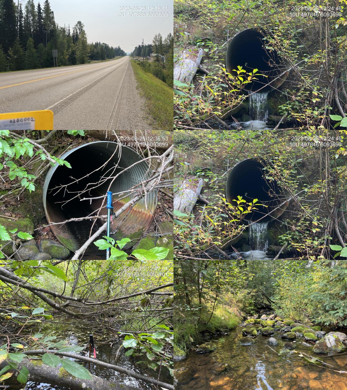 . From top left clockwise: Road/Site Card, Barrel, Outlet, Downstream, Upstream, Inlet.2200002 . From top left clockwise: Road/Site Card, Barrel, Outlet, Downstream, Upstream, Inlet.2200002
|
|||
| Comments: Stream is located between McLeod Lake Store on Highway and TseKhene food and fuel entrance. Most of the watershed drains reservation land. Could potentially be backwatered as an interim solution. Channel width estimated upstream in wetland type habitat so difficult to tell. Upstream end of the pipe is significantly sloped in the upstream direction. Ministry of Transportation chris_culvert_id: 1997114. 12:31:49 |
| Location and Stream Data |
|
Crossing Characteristics | – |
|---|---|---|---|
| Date | 2023-08-25 | Crossing Sub Type | Round Culvert |
| PSCIS ID | 198667 | Diameter (m) | 2.5 |
| External ID | 2200779 | Length (m) | 34 |
| Crew | AI | Embedded | No |
| UTM Zone | 10 | Depth Embedded (m) | – |
| Easting | 500631.7 | Resemble Channel | No |
| Northing | 6089784 | Backwatered | No |
| Stream | Tsatchuka Creek | Percent Backwatered | – |
| Road | Highway 97 | Fill Depth (m) | 2 |
| Road Tenure | MOTI | Outlet Drop (m) | 0 |
| Channel Width (m) | 4 | Outlet Pool Depth (m) | 1 |
| Stream Slope (%) | 0.5 | Inlet Drop | Yes |
| Beaver Activity | Yes | Slope (%) | 0.5 |
| Habitat Value | Medium | Valley Fill | Deep Fill |
| Final score | 22 | Barrier Result | Barrier |
| Fix type | Replace with New Open Bottom Structure | Fix Span / Diameter | 14 |
Photos: PSCIS ID 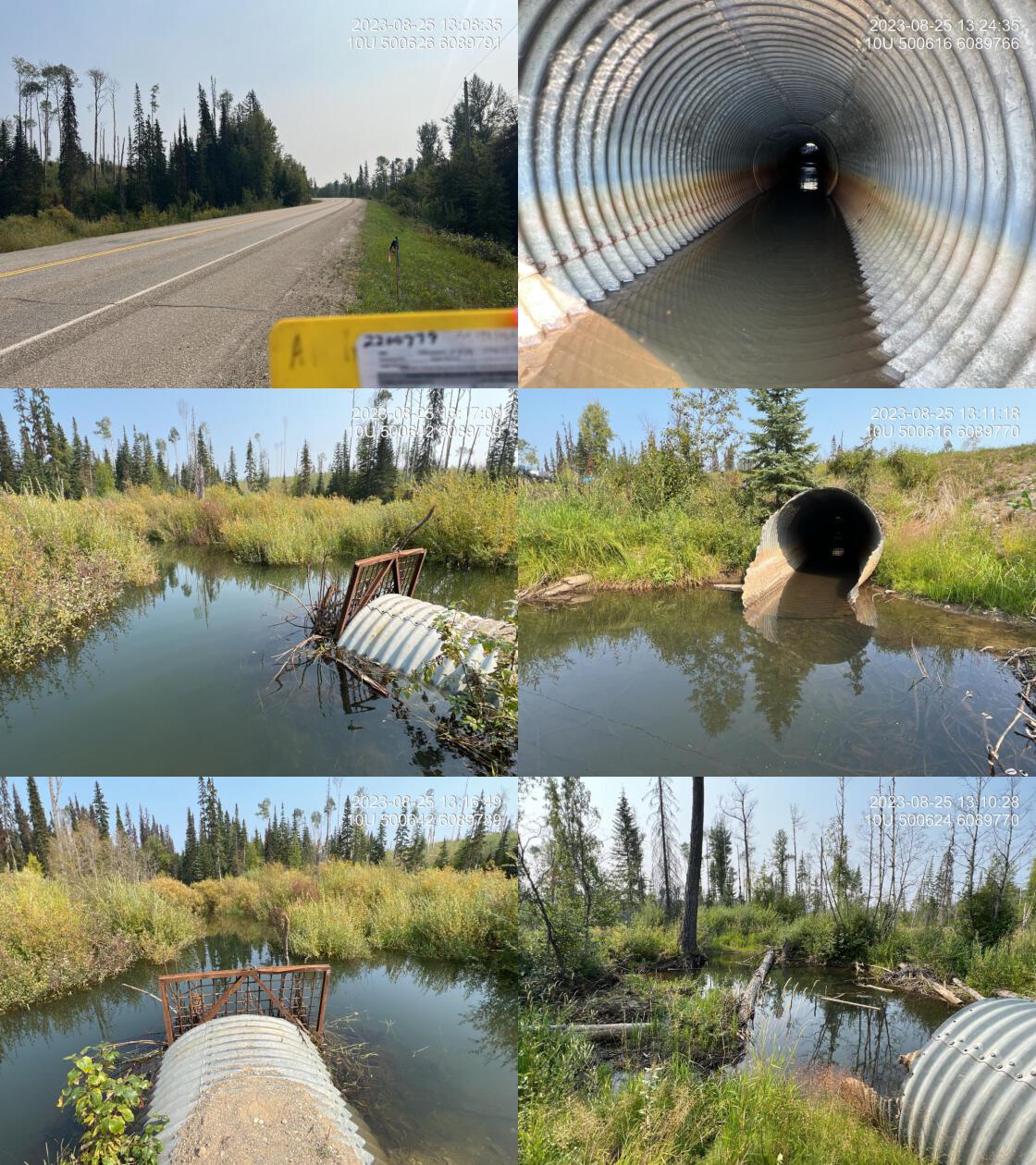 . From top left clockwise: Road/Site Card, Barrel, Outlet, Downstream, Upstream, Inlet.2200779 . From top left clockwise: Road/Site Card, Barrel, Outlet, Downstream, Upstream, Inlet.2200779
|
|||
| Comments: Grate on inlet and beaver influenced wetland upstream. Inlet blocked by beaver debris with beaver trap on inlet. Potentially good candidate for leveler to maintain beaver activity without attempting to remove the animals. Ministry of Transportation chris_culvert_id: 1997066. 13:04:57 |
| Location and Stream Data |
|
Crossing Characteristics | – |
|---|---|---|---|
| Date | 2023-08-25 | Crossing Sub Type | Round Culvert |
| PSCIS ID | 198668 | Diameter (m) | 1.2 |
| External ID | 2200604 | Length (m) | 50 |
| Crew | AI | Embedded | No |
| UTM Zone | 10 | Depth Embedded (m) | – |
| Easting | 501962.9 | Resemble Channel | No |
| Northing | 6087826 | Backwatered | No |
| Stream | Tributary to McLeod Lake | Percent Backwatered | – |
| Road | Highway 97 | Fill Depth (m) | 6 |
| Road Tenure | MOTI | Outlet Drop (m) | 0.8 |
| Channel Width (m) | 1.9 | Outlet Pool Depth (m) | 0.6 |
| Stream Slope (%) | 3 | Inlet Drop | Yes |
| Beaver Activity | Yes | Slope (%) | 1 |
| Habitat Value | Medium | Valley Fill | Deep Fill |
| Final score | 37 | Barrier Result | Barrier |
| Fix type | Replace Structure with Streambed Simulation CBS | Fix Span / Diameter | 3 |
Photos: PSCIS ID 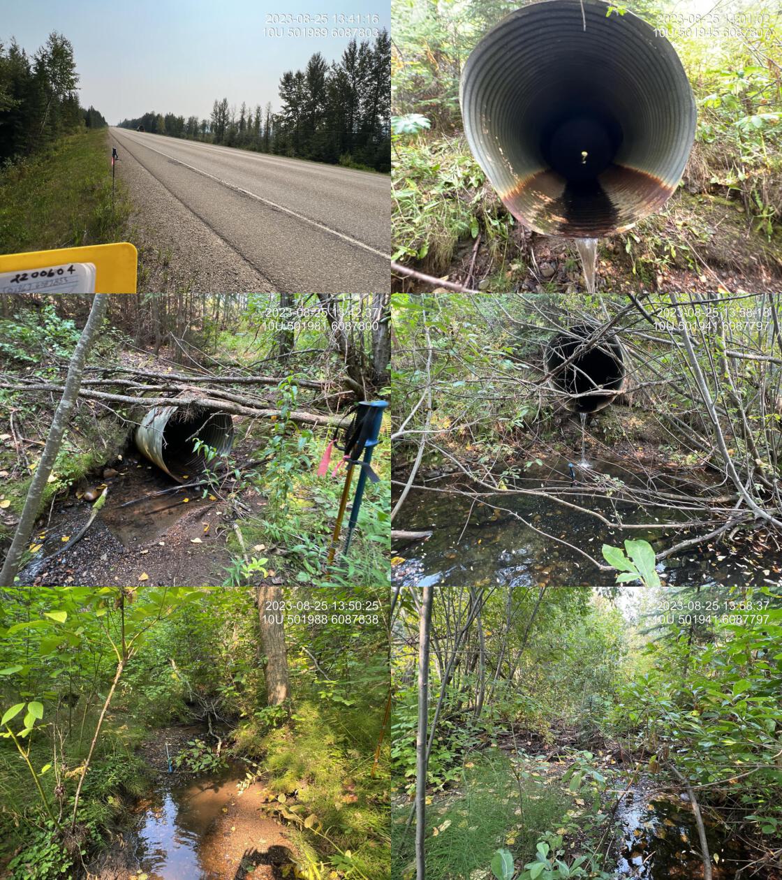 . From top left clockwise: Road/Site Card, Barrel, Outlet, Downstream, Upstream, Inlet.2200604 . From top left clockwise: Road/Site Card, Barrel, Outlet, Downstream, Upstream, Inlet.2200604
|
|||
| Comments: Abundant gravels, suitable for spawning upstream. Although flows are minimal, the streams does still have water. Models as having over 3 km of habitat upstream below 5%. Although no fish are recorded as present upstream it seems highly likely that this would be a fish bearing stream. Outlet drop is 80cm. Steep section of pipe at the inlet recorded as inlet drop. Ministry of Transportation chris_culvert_id: 1996852. 13:40:04 |
| Location and Stream Data |
|
Crossing Characteristics | – |
|---|---|---|---|
| Date | 2023-08-25 | Crossing Sub Type | Round Culvert |
| PSCIS ID | 198669 | Diameter (m) | 0.9 |
| External ID | 2200026 | Length (m) | 40 |
| Crew | AI | Embedded | No |
| UTM Zone | 10 | Depth Embedded (m) | – |
| Easting | 503356.4 | Resemble Channel | No |
| Northing | 6085974 | Backwatered | No |
| Stream | Tributary to McLeod Lake | Percent Backwatered | – |
| Road | Highway 97 | Fill Depth (m) | 5 |
| Road Tenure | MOTI | Outlet Drop (m) | 0.4 |
| Channel Width (m) | 3.3 | Outlet Pool Depth (m) | 1.3 |
| Stream Slope (%) | 4 | Inlet Drop | No |
| Beaver Activity | Yes | Slope (%) | 3 |
| Habitat Value | Medium | Valley Fill | Deep Fill |
| Final score | 42 | Barrier Result | Barrier |
| Fix type | Replace with New Open Bottom Structure | Fix Span / Diameter | 16 |
Photos: PSCIS ID 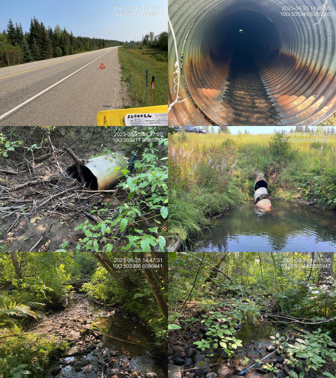 . From top left clockwise: Road/Site Card, Barrel, Outlet, Downstream, Upstream, Inlet.2200026 . From top left clockwise: Road/Site Card, Barrel, Outlet, Downstream, Upstream, Inlet.2200026
|
|||
| Comments: Culvert is extremely under sized. Nice stream with pockets of gravel and good flow upstream. Rainbow known in the system. Culvert is literally unravelling at the downstream end with a very large outlet pool. Beaver activity noted downstream. Seems very unlikely that any fish can pass through the pipe. Ministry of Transportation chris_culvert_id: 1996861. 14:23:42 |
| Location and Stream Data |
|
Crossing Characteristics | – |
|---|---|---|---|
| Date | 2023-08-25 | Crossing Sub Type | Bridge |
| PSCIS ID | 198670 | Diameter (m) | 6 |
| External ID | 2200119 | Length (m) | 8 |
| Crew | AI | Embedded | – |
| UTM Zone | 10 | Depth Embedded (m) | – |
| Easting | 503934.3 | Resemble Channel | – |
| Northing | 6084297 | Backwatered | – |
| Stream | Whiskers Creek | Percent Backwatered | – |
| Road | Campground Rd | Fill Depth (m) | – |
| Road Tenure | MOE | Outlet Drop (m) | – |
| Channel Width (m) | – | Outlet Pool Depth (m) | – |
| Stream Slope (%) | – | Inlet Drop | – |
| Beaver Activity | No | Slope (%) | – |
| Habitat Value | – | Valley Fill | – |
| Final score | 0 | Barrier Result | Passable |
| Fix type | – | Fix Span / Diameter | – |
Photos: PSCIS ID 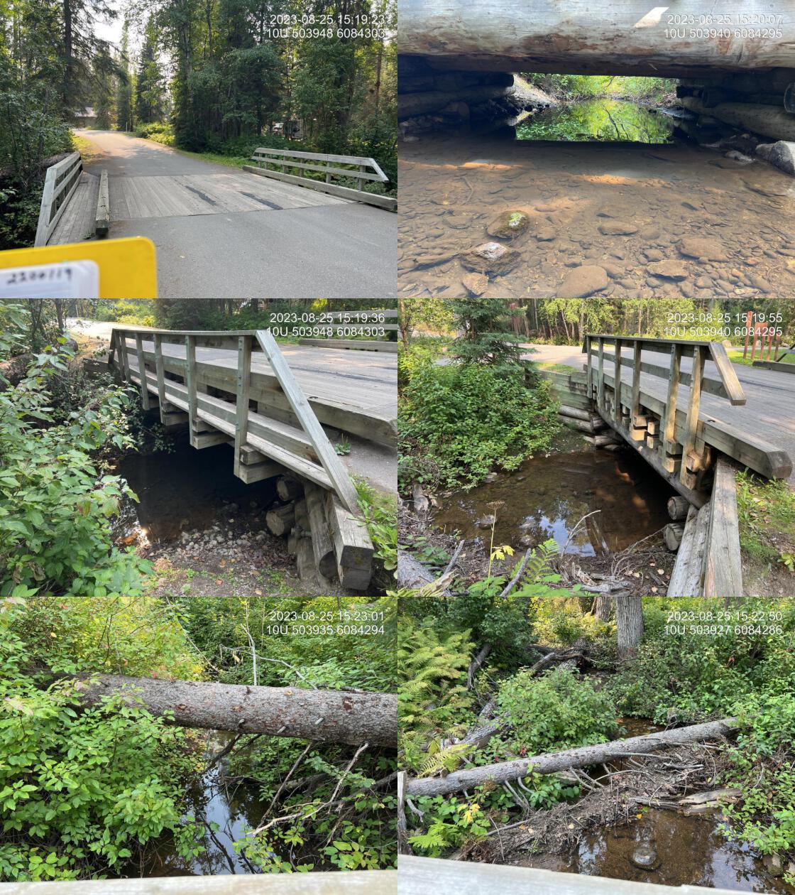 . From top left clockwise: Road/Site Card, Barrel, Outlet, Downstream, Upstream, Inlet.2200119 . From top left clockwise: Road/Site Card, Barrel, Outlet, Downstream, Upstream, Inlet.2200119
|
|||
| Comments: Nice little campground bridge. 15:20:36 |
| Location and Stream Data |
|
Crossing Characteristics | – |
|---|---|---|---|
| Date | 2023-08-25 | Crossing Sub Type | Bridge |
| PSCIS ID | 198671 | Diameter (m) | 6 |
| External ID | 2200114 | Length (m) | 7 |
| Crew | AI | Embedded | – |
| UTM Zone | 10 | Depth Embedded (m) | – |
| Easting | 503758.4 | Resemble Channel | – |
| Northing | 6084286 | Backwatered | – |
| Stream | Whiskers Creek | Percent Backwatered | – |
| Road | Campground Rd | Fill Depth (m) | – |
| Road Tenure | MOE | Outlet Drop (m) | – |
| Channel Width (m) | – | Outlet Pool Depth (m) | – |
| Stream Slope (%) | – | Inlet Drop | – |
| Beaver Activity | No | Slope (%) | – |
| Habitat Value | – | Valley Fill | – |
| Final score | 0 | Barrier Result | Passable |
| Fix type | – | Fix Span / Diameter | – |
Photos: PSCIS ID 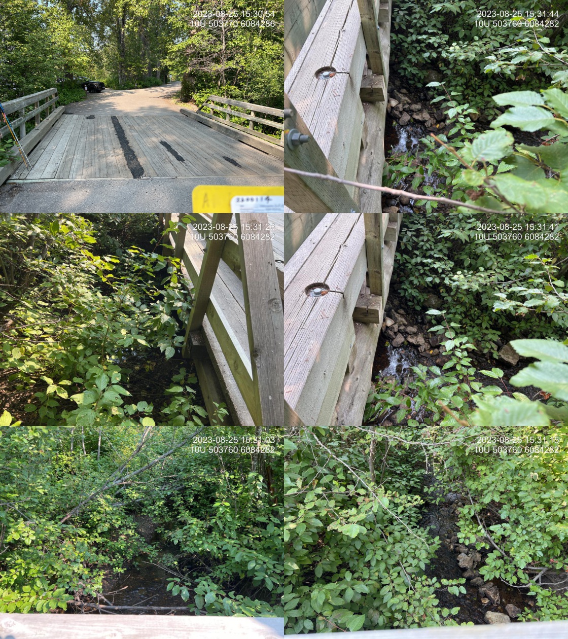 . From top left clockwise: Road/Site Card, Barrel, Outlet, Downstream, Upstream, Inlet.2200114 . From top left clockwise: Road/Site Card, Barrel, Outlet, Downstream, Upstream, Inlet.2200114
|
|||
| Comments: There are four bridges in total within 200m, with 2 inventoried. 15:32:10 |
| Location and Stream Data |
|
Crossing Characteristics | – |
|---|---|---|---|
| Date | 2023-08-25 | Crossing Sub Type | Round Culvert |
| PSCIS ID | 198672 | Diameter (m) | 2.5 |
| External ID | 2200014 | Length (m) | 35 |
| Crew | AI | Embedded | No |
| UTM Zone | 10 | Depth Embedded (m) | – |
| Easting | 504410.8 | Resemble Channel | No |
| Northing | 6084420 | Backwatered | No |
| Stream | Whiskers Creek | Percent Backwatered | – |
| Road | Highway 97 | Fill Depth (m) | 5 |
| Road Tenure | MOTI | Outlet Drop (m) | 0 |
| Channel Width (m) | 7 | Outlet Pool Depth (m) | 1.5 |
| Stream Slope (%) | 0 | Inlet Drop | No |
| Beaver Activity | Yes | Slope (%) | 2 |
| Habitat Value | Medium | Valley Fill | Deep Fill |
| Final score | 27 | Barrier Result | Barrier |
| Fix type | Replace with New Open Bottom Structure | Fix Span / Diameter | 16 |
Photos: PSCIS ID  . From top left clockwise: Road/Site Card, Barrel, Outlet, Downstream, Upstream, Inlet.2200014 . From top left clockwise: Road/Site Card, Barrel, Outlet, Downstream, Upstream, Inlet.2200014
|
|||
| Comments: Beaver activity downstream with extensive beaver influence wetlands upstream. 1 1/2 m high blockage at the inlet to to beaver activity. Stream width difficult to estimate due to wetland nature of habitat upstream. This is the first road stream crossing on this stream to be an issue at all downstream, crossings or bridges within whiskers point provincial park campground. Ministry of Transportation chris_culvert_id: 1997172. 16:05:30 |
| Location and Stream Data |
|
Crossing Characteristics | – |
|---|---|---|---|
| Date | 2023-08-26 | Crossing Sub Type | Round Culvert |
| PSCIS ID | 198673 | Diameter (m) | 1.2 |
| External ID | 3702044 | Length (m) | 30 |
| Crew | MW | Embedded | Yes |
| UTM Zone | 10 | Depth Embedded (m) | 0.9 |
| Easting | 524197.9 | Resemble Channel | Yes |
| Northing | 6015328 | Backwatered | Yes |
| Stream | Miller Creek | Percent Backwatered | 100 |
| Road | Highway 97 | Fill Depth (m) | 5 |
| Road Tenure | MOTI | Outlet Drop (m) | 0 |
| Channel Width (m) | 2.1 | Outlet Pool Depth (m) | 1.6 |
| Stream Slope (%) | 2 | Inlet Drop | No |
| Beaver Activity | Yes | Slope (%) | 2 |
| Habitat Value | Low | Valley Fill | Deep Fill |
| Final score | 17 | Barrier Result | Potential |
| Fix type | Replace with New Open Bottom Structure | Fix Span / Diameter | 16 |
Photos: PSCIS ID 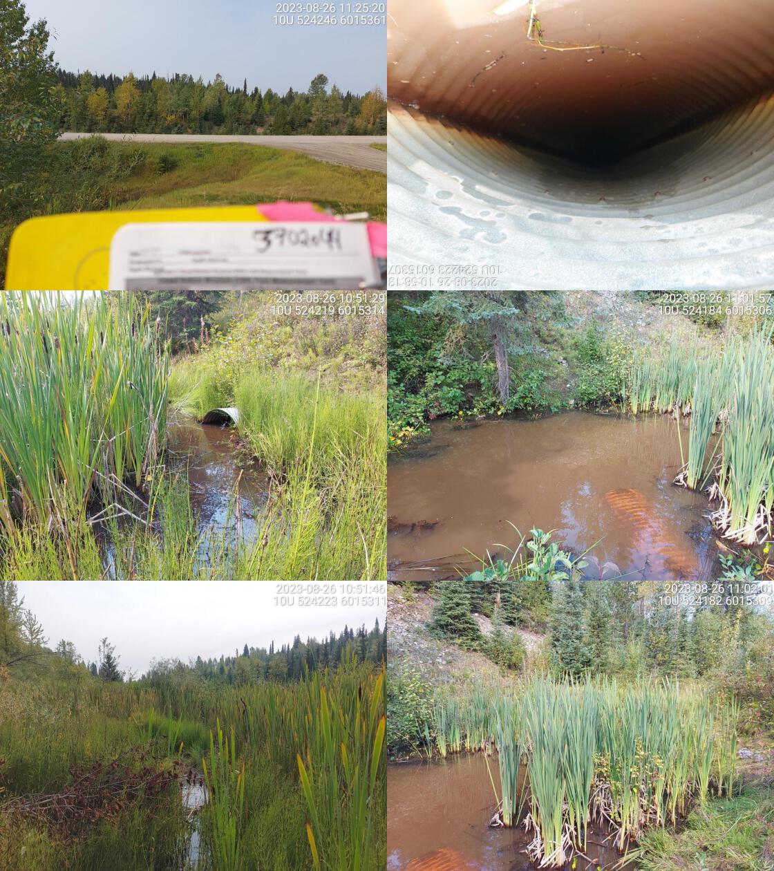 . From top left clockwise: Road/Site Card, Barrel, Outlet, Downstream, Upstream, Inlet.3702044 . From top left clockwise: Road/Site Card, Barrel, Outlet, Downstream, Upstream, Inlet.3702044
|
|||
| Comments: Culvert is fully submerged on outlet side. No stream found beyond outlet pool. Big wetland complex on upstream side. No defined channel. Stream slope, channel width, and culvert slope were estimated. Ministry of Transportation chris_culvert_id: 1996888. 11:04:17 |
| Location and Stream Data |
|
Crossing Characteristics | – |
|---|---|---|---|
| Date | 2023-08-26 | Crossing Sub Type | Round Culvert |
| PSCIS ID | 198674 | Diameter (m) | 0.8 |
| External ID | 3701553 | Length (m) | 12 |
| Crew | MW | Embedded | No |
| UTM Zone | 10 | Depth Embedded (m) | – |
| Easting | 524033.9 | Resemble Channel | No |
| Northing | 6015628 | Backwatered | No |
| Stream | Miller Creek | Percent Backwatered | – |
| Road | Summit Lake Rd | Fill Depth (m) | 1.5 |
| Road Tenure | MOTI Local | Outlet Drop (m) | 0 |
| Channel Width (m) | 2.4 | Outlet Pool Depth (m) | 0.6 |
| Stream Slope (%) | 2 | Inlet Drop | No |
| Beaver Activity | No | Slope (%) | 2.5 |
| Habitat Value | Low | Valley Fill | Deep Fill |
| Final score | 21 | Barrier Result | Barrier |
| Fix type | Replace with New Open Bottom Structure | Fix Span / Diameter | 14 |
Photos: PSCIS ID 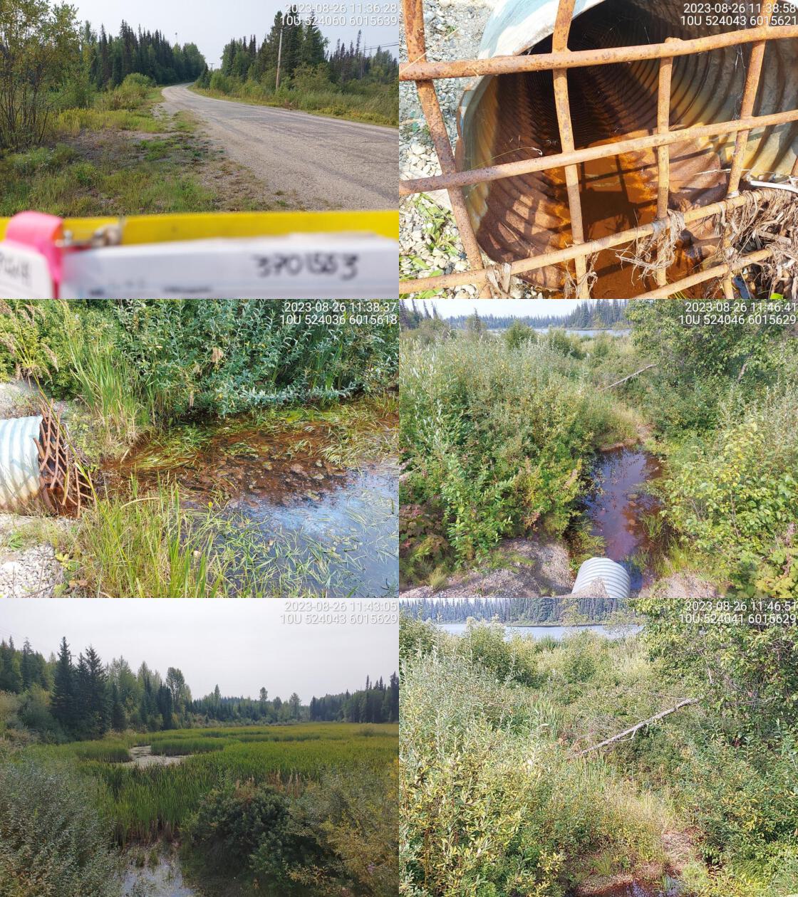 . From top left clockwise: Road/Site Card, Barrel, Outlet, Downstream, Upstream, Inlet.3701553 . From top left clockwise: Road/Site Card, Barrel, Outlet, Downstream, Upstream, Inlet.3701553
|
|||
| Comments: Beaver grate on inlet side. Big wetland area upstream and no defined stream channel seen. Some flow downstream. Very little flow through pipe. There is an unassessed crossing upstream, on railway (modelled crossing id 3703407). Ministry of Transportation chris_culvert_id: 3440699. 11:56:39 |
| Location and Stream Data |
|
Crossing Characteristics | – |
|---|---|---|---|
| Date | 2023-08-26 | Crossing Sub Type | Round Culvert |
| PSCIS ID | 198675 | Diameter (m) | 1.9 |
| External ID | 3701554 | Length (m) | 26 |
| Crew | MW | Embedded | No |
| UTM Zone | 10 | Depth Embedded (m) | – |
| Easting | 524469.3 | Resemble Channel | No |
| Northing | 6017855 | Backwatered | Yes |
| Stream | O’Dell Creek | Percent Backwatered | 100 |
| Road | Highway 97 | Fill Depth (m) | 3 |
| Road Tenure | MOTI | Outlet Drop (m) | 0 |
| Channel Width (m) | 1.9 | Outlet Pool Depth (m) | 0.8 |
| Stream Slope (%) | 1.5 | Inlet Drop | No |
| Beaver Activity | Yes | Slope (%) | 4 |
| Habitat Value | Medium | Valley Fill | Deep Fill |
| Final score | 26 | Barrier Result | Barrier |
| Fix type | Replace Structure with Streambed Simulation CBS | Fix Span / Diameter | 3 |
Photos: PSCIS ID 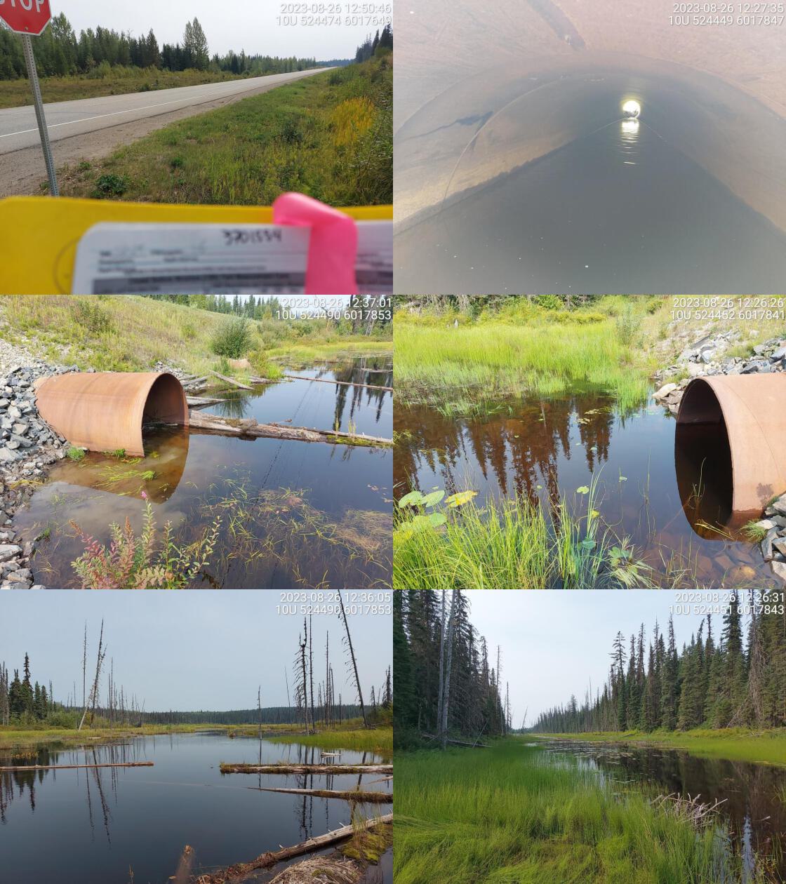 . From top left clockwise: Road/Site Card, Barrel, Outlet, Downstream, Upstream, Inlet.3701554 . From top left clockwise: Road/Site Card, Barrel, Outlet, Downstream, Upstream, Inlet.3701554
|
|||
| Comments: Debris jam at inlet creating small drop. Large wetland area upstream and downstream. No well defined channel. Burbot confirmed just upstream in the past, as well as downstream near Summit Lake. Ministry of Transportation chris_culvert_id: 1996948. 12:35:23 |
| Location and Stream Data |
|
Crossing Characteristics | – |
|---|---|---|---|
| Date | 2023-08-26 | Crossing Sub Type | Bridge |
| PSCIS ID | 198676 | Diameter (m) | 15 |
| External ID | 3702078 | Length (m) | 3 |
| Crew | MW | Embedded | – |
| UTM Zone | 10 | Depth Embedded (m) | – |
| Easting | 522732.5 | Resemble Channel | – |
| Northing | 6018668 | Backwatered | – |
| Stream | Neilson Creek | Percent Backwatered | – |
| Road | Caine Creek FSR | Fill Depth (m) | – |
| Road Tenure | Canfor R02852 | Outlet Drop (m) | – |
| Channel Width (m) | – | Outlet Pool Depth (m) | – |
| Stream Slope (%) | – | Inlet Drop | – |
| Beaver Activity | No | Slope (%) | – |
| Habitat Value | – | Valley Fill | – |
| Final score | 0 | Barrier Result | Passable |
| Fix type | – | Fix Span / Diameter | – |
Photos: PSCIS ID 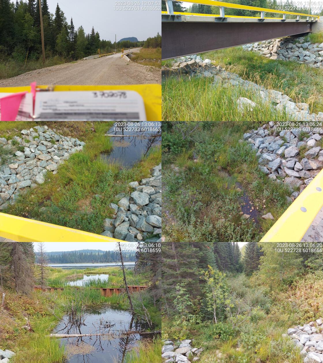 . From top left clockwise: Road/Site Card, Barrel, Outlet, Downstream, Upstream, Inlet.3702078 . From top left clockwise: Road/Site Card, Barrel, Outlet, Downstream, Upstream, Inlet.3702078
|
|||
| Comments: Neilsen Lake dam located approximately 30m upstream of bridge, near outlet of lake. Metal dam 1.8m in height and owned by Ministry of Environment. 13:08:06 |
| Location and Stream Data |
|
Crossing Characteristics | – |
|---|---|---|---|
| Date | 2023-08-26 | Crossing Sub Type | Round Culvert |
| PSCIS ID | 198677 | Diameter (m) | 0.8 |
| External ID | 3702075 | Length (m) | 12 |
| Crew | MW | Embedded | No |
| UTM Zone | 10 | Depth Embedded (m) | – |
| Easting | 522191.8 | Resemble Channel | No |
| Northing | 6020073 | Backwatered | Yes |
| Stream | Witters Creek | Percent Backwatered | 50 |
| Road | Caine Creek FSR | Fill Depth (m) | 0.3 |
| Road Tenure | Canfor R02852 | Outlet Drop (m) | 0.2 |
| Channel Width (m) | 2 | Outlet Pool Depth (m) | 0.3 |
| Stream Slope (%) | 2 | Inlet Drop | No |
| Beaver Activity | Yes | Slope (%) | 0 |
| Habitat Value | Medium | Valley Fill | Deep Fill |
| Final score | 21 | Barrier Result | Barrier |
| Fix type | Replace with New Open Bottom Structure | Fix Span / Diameter | 14 |
Photos: PSCIS ID 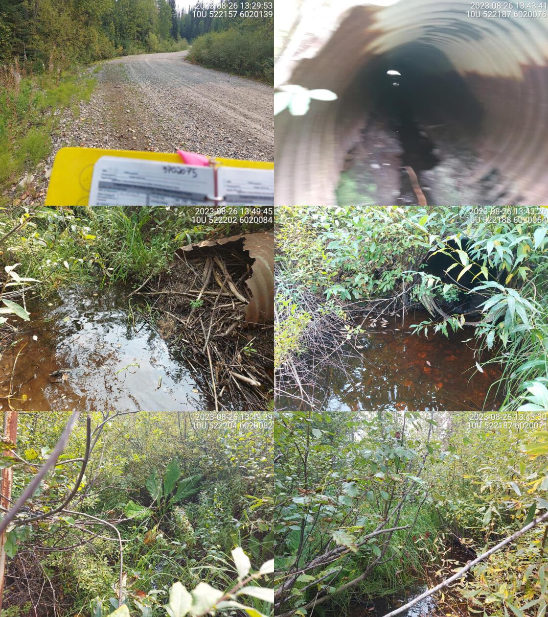 . From top left clockwise: Road/Site Card, Barrel, Outlet, Downstream, Upstream, Inlet.3702075 . From top left clockwise: Road/Site Card, Barrel, Outlet, Downstream, Upstream, Inlet.3702075
|
|||
| Comments: Culvert is in very bad condition. Debris jam blocking inlet, likely beaver caused.. Stream habitat is ok, some deep pools and abundant riparian vegetation. 13:51:42 |
| Location and Stream Data |
|
Crossing Characteristics | – |
|---|---|---|---|
| Date | 2023-08-26 | Crossing Sub Type | Round Culvert |
| PSCIS ID | 198678 | Diameter (m) | 0.75 |
| External ID | 3700005 | Length (m) | 23 |
| Crew | MW | Embedded | No |
| UTM Zone | 10 | Depth Embedded (m) | – |
| Easting | 522683.9 | Resemble Channel | No |
| Northing | 6022233 | Backwatered | No |
| Stream | Witters Creek | Percent Backwatered | – |
| Road | Highway 97 | Fill Depth (m) | 1 |
| Road Tenure | MOTI | Outlet Drop (m) | 0 |
| Channel Width (m) | 2.3 | Outlet Pool Depth (m) | 0 |
| Stream Slope (%) | 2 | Inlet Drop | No |
| Beaver Activity | No | Slope (%) | 4 |
| Habitat Value | Low | Valley Fill | Deep Fill |
| Final score | 29 | Barrier Result | Barrier |
| Fix type | Replace with New Open Bottom Structure | Fix Span / Diameter | 14 |
Photos: PSCIS ID 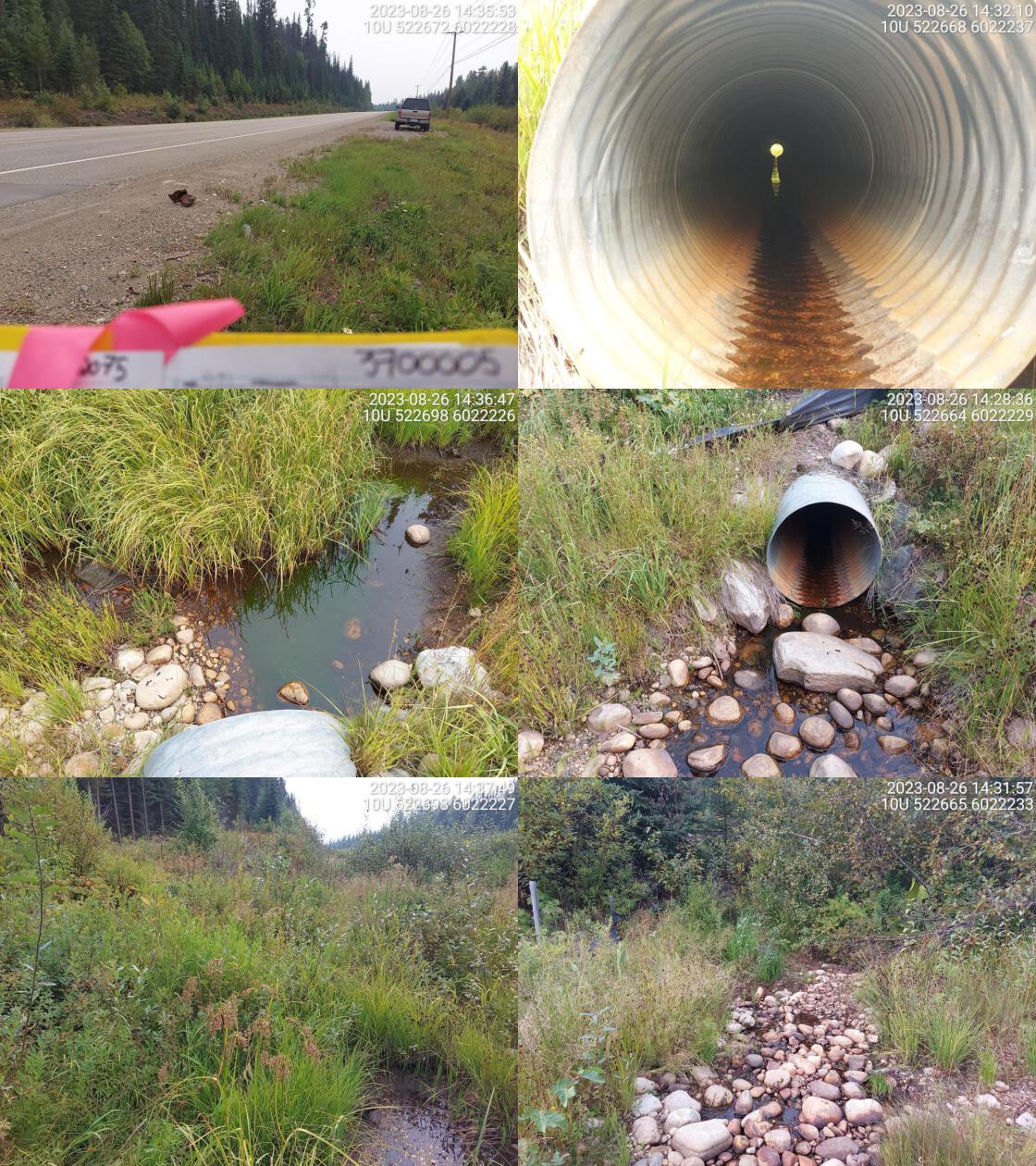 . From top left clockwise: Road/Site Card, Barrel, Outlet, Downstream, Upstream, Inlet.3700005 . From top left clockwise: Road/Site Card, Barrel, Outlet, Downstream, Upstream, Inlet.3700005
|
|||
| Comments: No visible channel upstream. Very little flow through culvert. Some water and cobbles at outlet. Ministry of Transportation chris_culvert_id: 1997258. 14:42:45 |
| Location and Stream Data |
|
Crossing Characteristics | – |
|---|---|---|---|
| Date | 2023-08-26 | Crossing Sub Type | Round Culvert |
| PSCIS ID | 198679 | Diameter (m) | 0.6 |
| External ID | 3703410 | Length (m) | 17 |
| Crew | MW | Embedded | No |
| UTM Zone | 10 | Depth Embedded (m) | – |
| Easting | 522653.6 | Resemble Channel | No |
| Northing | 6022232 | Backwatered | No |
| Stream | Witters Creek | Percent Backwatered | – |
| Road | Railway | Fill Depth (m) | 2 |
| Road Tenure | CN Rail | Outlet Drop (m) | 0.1 |
| Channel Width (m) | 1.9 | Outlet Pool Depth (m) | 0.4 |
| Stream Slope (%) | 1.5 | Inlet Drop | No |
| Beaver Activity | No | Slope (%) | 1 |
| Habitat Value | Low | Valley Fill | Deep Fill |
| Final score | 24 | Barrier Result | Barrier |
| Fix type | Replace Structure with Streambed Simulation CBS | Fix Span / Diameter | 3 |
Photos: PSCIS ID 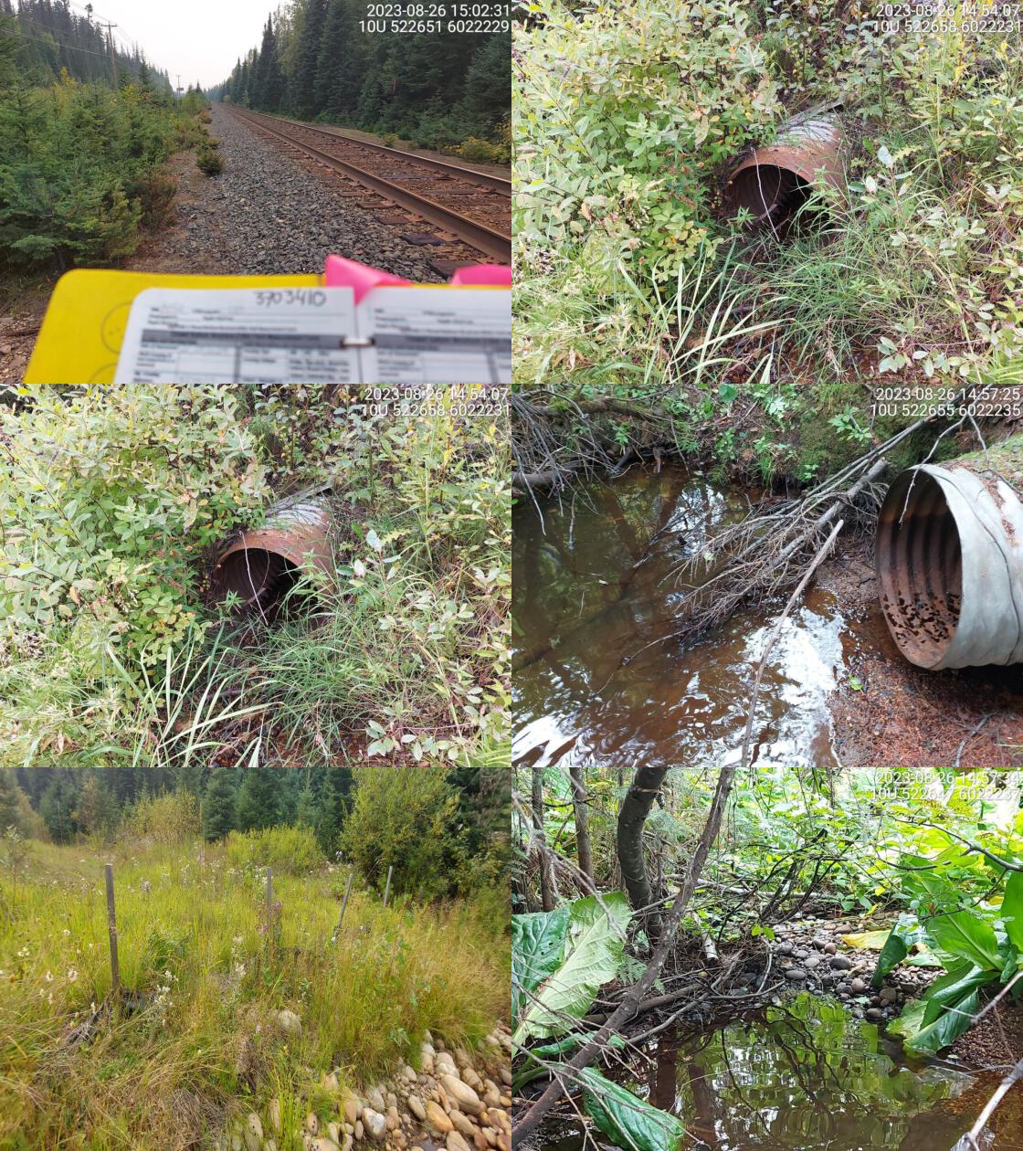 . From top left clockwise: Road/Site Card, Barrel, Outlet, Downstream, Upstream, Inlet.3703410 . From top left clockwise: Road/Site Card, Barrel, Outlet, Downstream, Upstream, Inlet.3703410
|
|||
| Comments: Small amount of water in pipe. Channel is overgrown downstream. Almost no flow in stream. 15:01:34 |
| Location and Stream Data |
|
Crossing Characteristics | – |
|---|---|---|---|
| Date | 2023-08-26 | Crossing Sub Type | Round Culvert |
| PSCIS ID | 198680 | Diameter (m) | 1.1 |
| External ID | 3700003 | Length (m) | 26 |
| Crew | MW | Embedded | Yes |
| UTM Zone | 10 | Depth Embedded (m) | 0.6 |
| Easting | 523141.4 | Resemble Channel | Yes |
| Northing | 6019903 | Backwatered | Yes |
| Stream | Neilson Creek | Percent Backwatered | 100 |
| Road | Highway 97 | Fill Depth (m) | 3.5 |
| Road Tenure | MOTI | Outlet Drop (m) | 0 |
| Channel Width (m) | 2.3 | Outlet Pool Depth (m) | 0.6 |
| Stream Slope (%) | 1.5 | Inlet Drop | No |
| Beaver Activity | No | Slope (%) | 1.5 |
| Habitat Value | Low | Valley Fill | Deep Fill |
| Final score | 14 | Barrier Result | Passable |
| Fix type | – | Fix Span / Diameter | – |
Photos: PSCIS ID 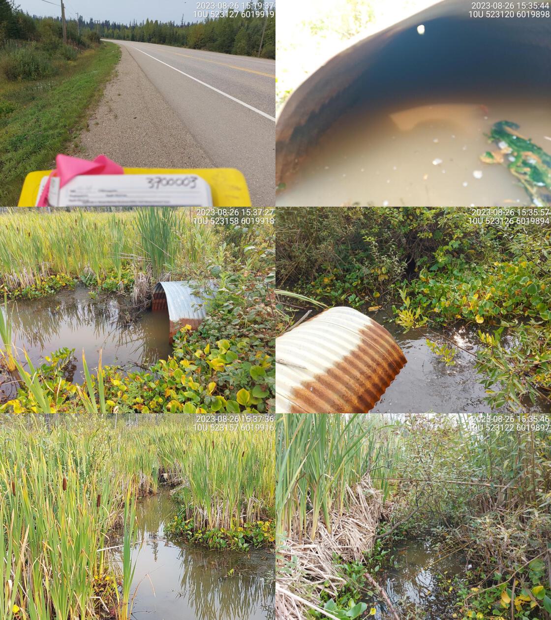 . From top left clockwise: Road/Site Card, Barrel, Outlet, Downstream, Upstream, Inlet.3700003 . From top left clockwise: Road/Site Card, Barrel, Outlet, Downstream, Upstream, Inlet.3700003
|
|||
| Comments: Wetland habitat, no flow. No culvert found south where modelled crossing is supposed to be on map. Unassessed railway crossing downstream. Ministry of Transportation chris_culvert_id: 1997273. 15:40:25 |
| Location and Stream Data |
|
Crossing Characteristics | – |
|---|---|---|---|
| Date | 2023-08-26 | Crossing Sub Type | Bridge |
| PSCIS ID | 198681 | Diameter (m) | 3.5 |
| External ID | 3703324 | Length (m) | 7 |
| Crew | MW | Embedded | – |
| UTM Zone | 10 | Depth Embedded (m) | – |
| Easting | 519257.5 | Resemble Channel | – |
| Northing | 6038651 | Backwatered | – |
| Stream | Tributary to Crooked River | Percent Backwatered | – |
| Road | Davie-Bear Lake FSR | Fill Depth (m) | – |
| Road Tenure | MOF 7719 | Outlet Drop (m) | – |
| Channel Width (m) | – | Outlet Pool Depth (m) | – |
| Stream Slope (%) | – | Inlet Drop | – |
| Beaver Activity | No | Slope (%) | – |
| Habitat Value | – | Valley Fill | – |
| Final score | 0 | Barrier Result | Passable |
| Fix type | – | Fix Span / Diameter | – |
Photos: PSCIS ID 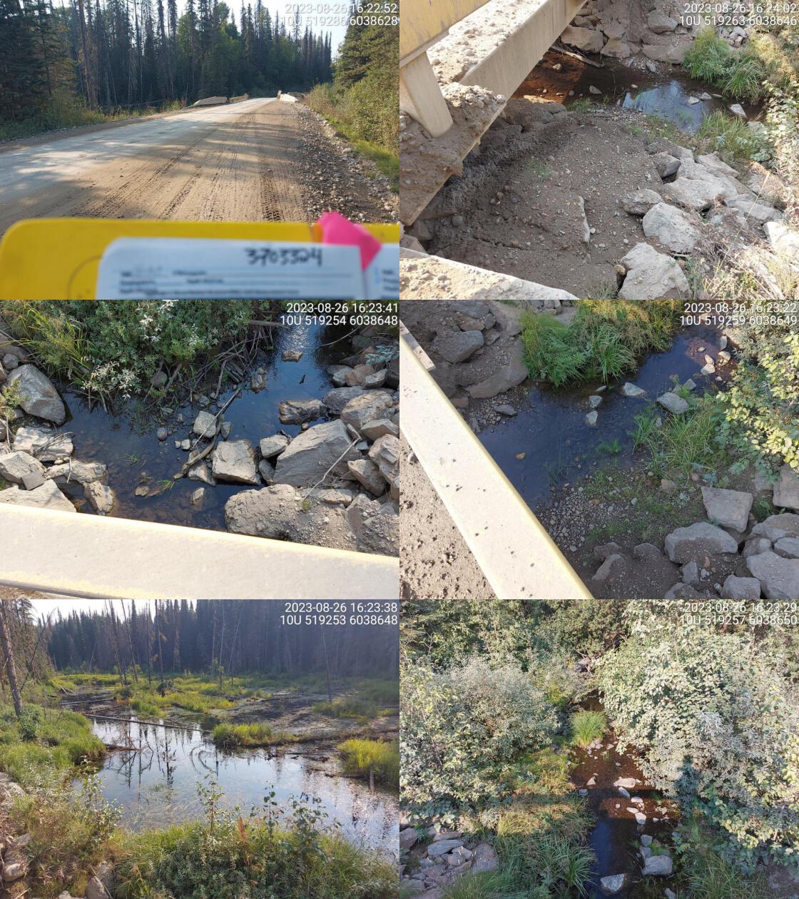 . From top left clockwise: Road/Site Card, Barrel, Outlet, Downstream, Upstream, Inlet.3703324 . From top left clockwise: Road/Site Card, Barrel, Outlet, Downstream, Upstream, Inlet.3703324
|
|||
| Comments: Burbot and bull trout confirmed upstream in past. Wetland upstream. 16:24:42 |
| Location and Stream Data |
|
Crossing Characteristics | – |
|---|---|---|---|
| Date | 2023-08-26 | Crossing Sub Type | Round Culvert |
| PSCIS ID | 198682 | Diameter (m) | 1.7 |
| External ID | 3700007 | Length (m) | 22 |
| Crew | MW | Embedded | No |
| UTM Zone | 10 | Depth Embedded (m) | – |
| Easting | 520696.1 | Resemble Channel | No |
| Northing | 6037970 | Backwatered | Yes |
| Stream | Tributary to Crooked River | Percent Backwatered | 100 |
| Road | Highway 97 | Fill Depth (m) | 4 |
| Road Tenure | MOTI | Outlet Drop (m) | 0 |
| Channel Width (m) | 1.7 | Outlet Pool Depth (m) | 0.4 |
| Stream Slope (%) | 1 | Inlet Drop | No |
| Beaver Activity | No | Slope (%) | 2.5 |
| Habitat Value | Low | Valley Fill | Deep Fill |
| Final score | 21 | Barrier Result | Barrier |
| Fix type | Replace Structure with Streambed Simulation CBS | Fix Span / Diameter | 3 |
Photos: PSCIS ID 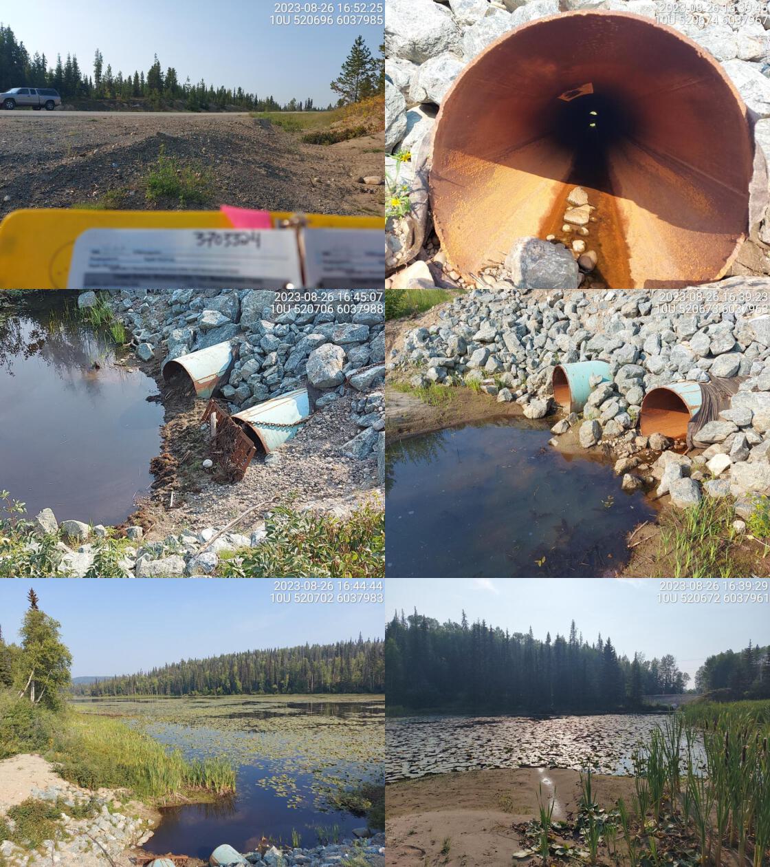 . From top left clockwise: Road/Site Card, Barrel, Outlet, Downstream, Upstream, Inlet.3700007 . From top left clockwise: Road/Site Card, Barrel, Outlet, Downstream, Upstream, Inlet.3700007
|
|||
| Comments: Two pipes. Big wetland upstream and downstream. No well defined channel. Ministry of Transportation chris_culvert_id: 1997232. 16:47:59 |
| Location and Stream Data |
|
Crossing Characteristics | – |
|---|---|---|---|
| Date | 2023-08-26 | Crossing Sub Type | Round Culvert |
| PSCIS ID | 198683 | Diameter (m) | 1.2 |
| External ID | 3700006 | Length (m) | 18 |
| Crew | MW | Embedded | No |
| UTM Zone | 10 | Depth Embedded (m) | – |
| Easting | 523556.6 | Resemble Channel | No |
| Northing | 6024872 | Backwatered | Yes |
| Stream | Tributary to Crooked River | Percent Backwatered | 100 |
| Road | Highway 97 | Fill Depth (m) | 1 |
| Road Tenure | MOTI | Outlet Drop (m) | 0 |
| Channel Width (m) | 3.4 | Outlet Pool Depth (m) | 0.8 |
| Stream Slope (%) | 1 | Inlet Drop | No |
| Beaver Activity | No | Slope (%) | 0.5 |
| Habitat Value | Medium | Valley Fill | Deep Fill |
| Final score | 19 | Barrier Result | Potential |
| Fix type | Replace with New Open Bottom Structure | Fix Span / Diameter | 14 |
Photos: PSCIS ID 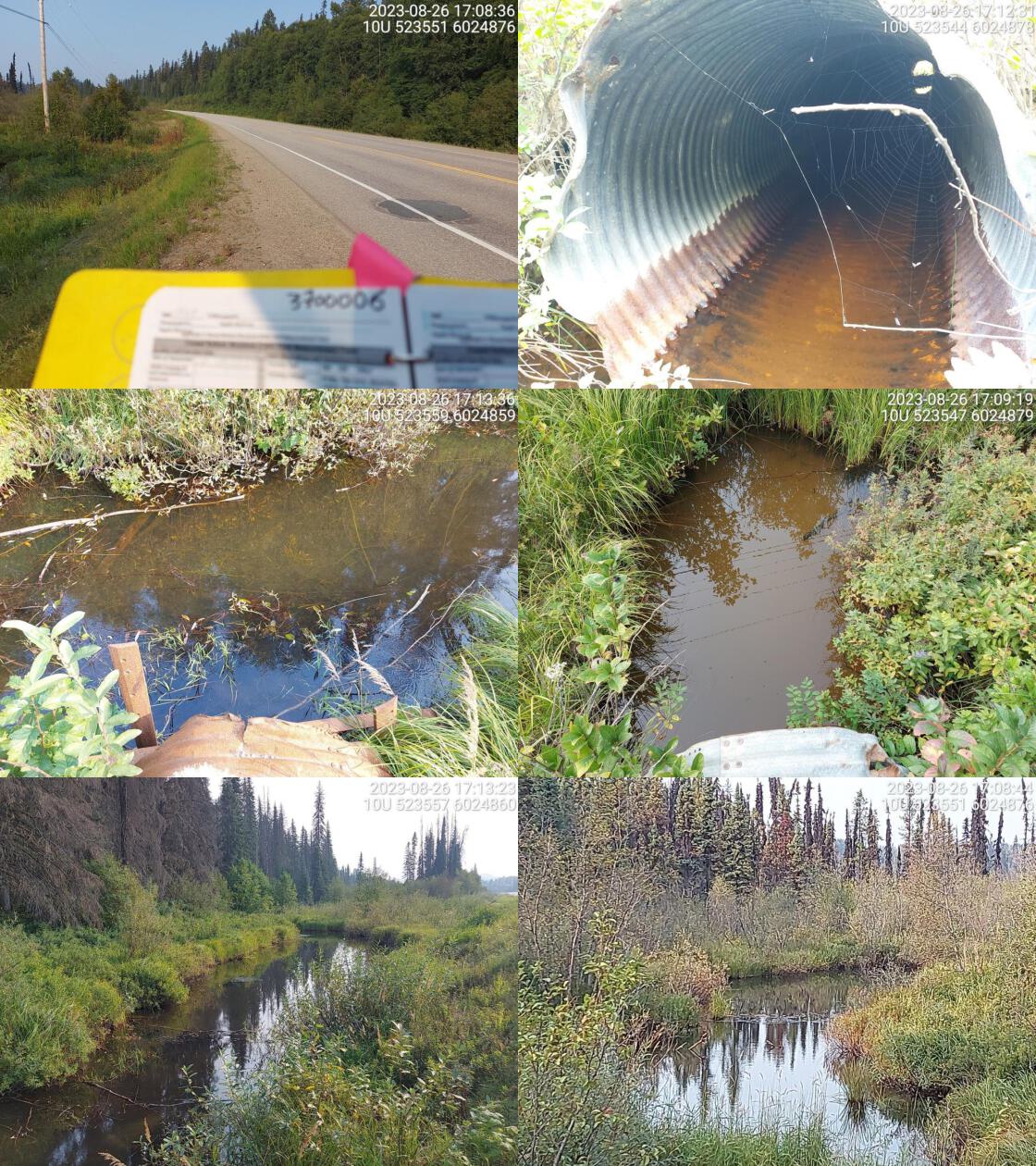 . From top left clockwise: Road/Site Card, Barrel, Outlet, Downstream, Upstream, Inlet.3700006 . From top left clockwise: Road/Site Card, Barrel, Outlet, Downstream, Upstream, Inlet.3700006
|
|||
| Comments: Backwatered, wetland downstream. Culvert is rusted. Four small lakes upstream, including Augustine, Log, and Cloud Lake. Fish presence confirmed in Augustine Lake (RB, SU, NSC and RSC). Unassessed crossing (modelled id 3703412) located downstream of highway on railway, near the confluence with Crooked River. Ministry of Transportation chris_culvert_id: 1997146. 17:17:30 |
| Location and Stream Data |
|
Crossing Characteristics | – |
|---|---|---|---|
| Date | 2023-08-26 | Crossing Sub Type | Round Culvert |
| PSCIS ID | 198684 | Diameter (m) | 1.8 |
| External ID | 3700019 | Length (m) | 36 |
| Crew | AI | Embedded | No |
| UTM Zone | 10 | Depth Embedded (m) | – |
| Easting | 514827.2 | Resemble Channel | No |
| Northing | 6059932 | Backwatered | Yes |
| Stream | Tributary to Kerry Lake | Percent Backwatered | 100 |
| Road | Highway 97 | Fill Depth (m) | 3 |
| Road Tenure | MOTI | Outlet Drop (m) | 0 |
| Channel Width (m) | 5 | Outlet Pool Depth (m) | 0.4 |
| Stream Slope (%) | 1 | Inlet Drop | Yes |
| Beaver Activity | Yes | Slope (%) | 0.5 |
| Habitat Value | Medium | Valley Fill | Deep Fill |
| Final score | 22 | Barrier Result | Barrier |
| Fix type | Replace with New Open Bottom Structure | Fix Span / Diameter | 14 |
Photos: PSCIS ID 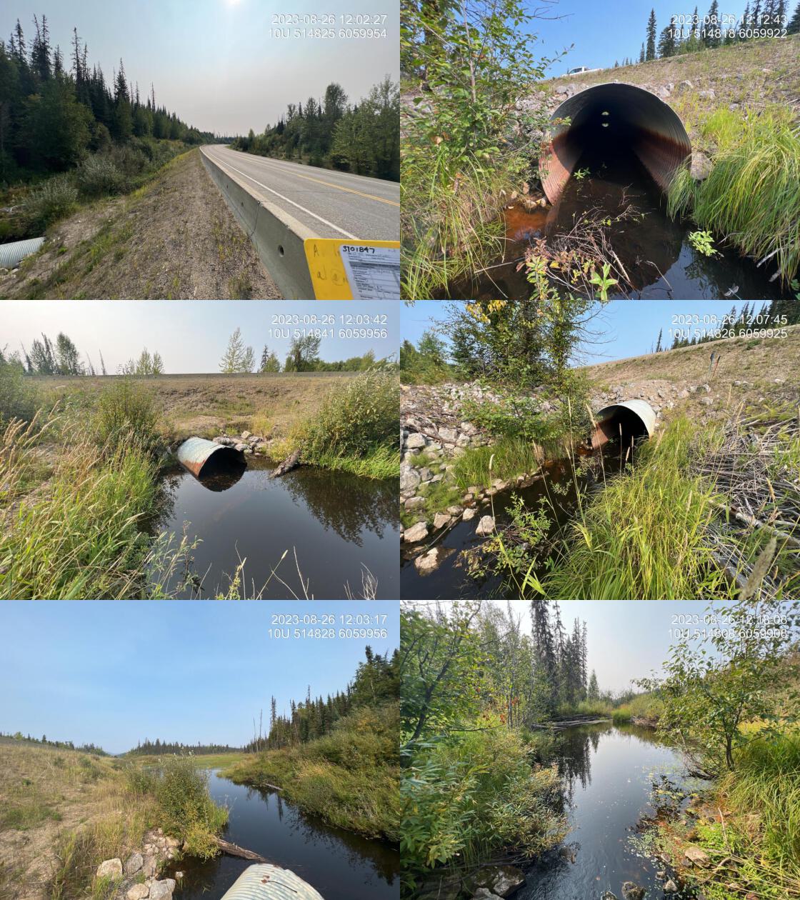 . From top left clockwise: Road/Site Card, Barrel, Outlet, Downstream, Upstream, Inlet.3700019 . From top left clockwise: Road/Site Card, Barrel, Outlet, Downstream, Upstream, Inlet.3700019
|
|||
| Comments: 100% backwatered culvert with lots of beaver activity and wetland area upstream. Inlet drop is created by beaver generated shrub material so backwatering is happening. However, there is a step of approximately 0.6 m at the top end of the pipe. Black algae throughout channel downstream. Downstream channel appears to be constructed of rock at approximately 3.8 m wide before entering more beaverdam influenced wetland habitat. Ministry of Transportation chris_culvert_id: 1996976. 12:08:15 |
| Location and Stream Data |
|
Crossing Characteristics | – |
|---|---|---|---|
| Date | 2023-08-26 | Crossing Sub Type | Ford |
| PSCIS ID | 198685 | Diameter (m) | – |
| External ID | 3701847 | Length (m) | – |
| Crew | AI | Embedded | – |
| UTM Zone | 10 | Depth Embedded (m) | – |
| Easting | 514810.1 | Resemble Channel | – |
| Northing | 6059906 | Backwatered | – |
| Stream | Tributary to Kerry Lake | Percent Backwatered | – |
| Road | Pipeline | Fill Depth (m) | – |
| Road Tenure | Unclassified | Outlet Drop (m) | – |
| Channel Width (m) | – | Outlet Pool Depth (m) | – |
| Stream Slope (%) | – | Inlet Drop | – |
| Beaver Activity | No | Slope (%) | – |
| Habitat Value | – | Valley Fill | – |
| Final score | 0 | Barrier Result | Unknown |
| Fix type | – | Fix Span / Diameter | – |
Photos: PSCIS ID 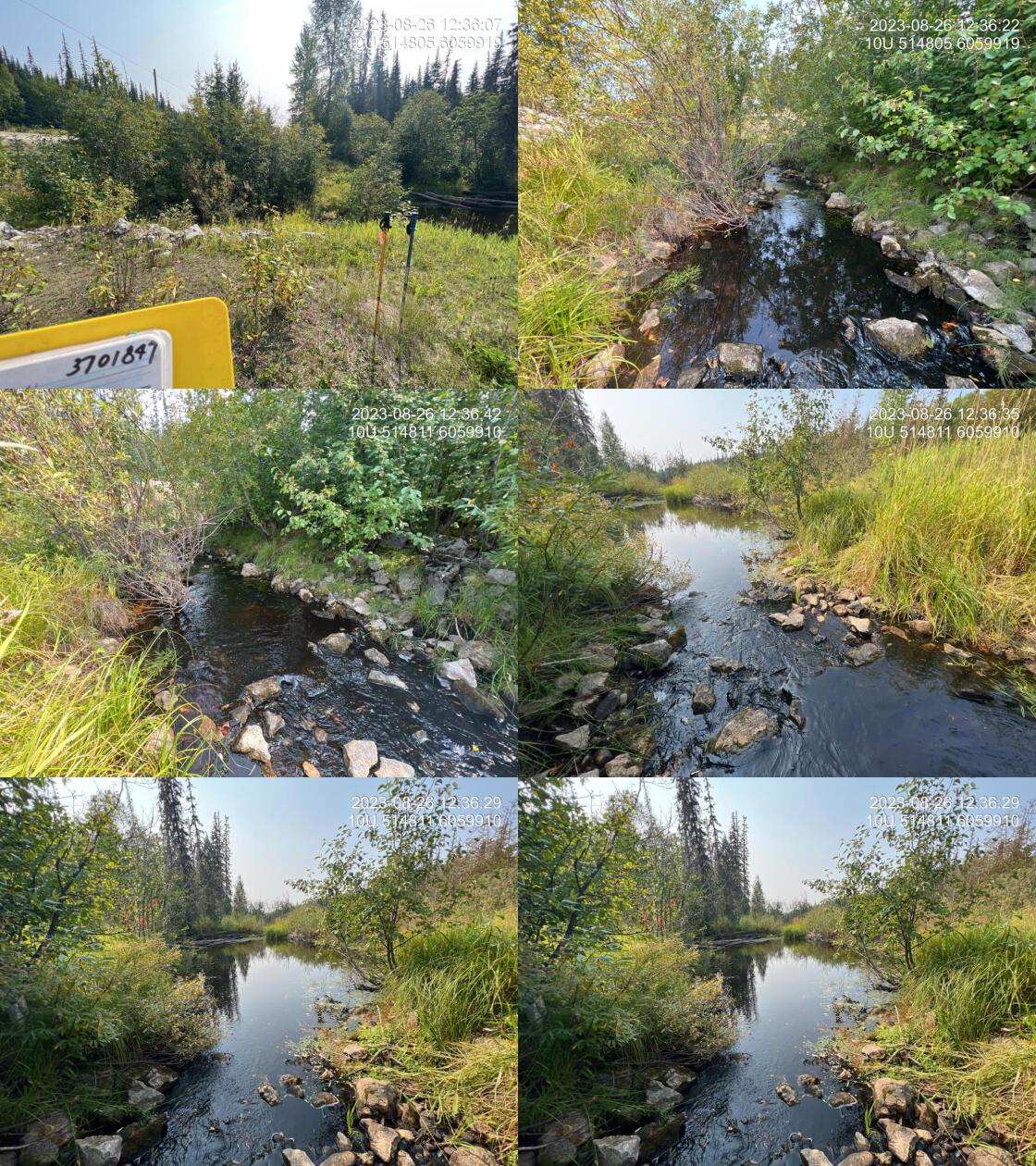 . From top left clockwise: Road/Site Card, Barrel, Outlet, Downstream, Upstream, Inlet.3701847 . From top left clockwise: Road/Site Card, Barrel, Outlet, Downstream, Upstream, Inlet.3701847
|
|||
| Comments: Armoured ford on pipeline. Immediately downstream of highway. 12:36:50 |
| Location and Stream Data |
|
Crossing Characteristics | – |
|---|---|---|---|
| Date | 2023-08-26 | Crossing Sub Type | Round Culvert |
| PSCIS ID | 198686 | Diameter (m) | 0.5 |
| External ID | 3700023 | Length (m) | 30 |
| Crew | AI | Embedded | Yes |
| UTM Zone | 10 | Depth Embedded (m) | 0.1 |
| Easting | 510940.3 | Resemble Channel | Yes |
| Northing | 6071748 | Backwatered | Yes |
| Stream | Tributary to Crooked River | Percent Backwatered | 100 |
| Road | Highway 97 | Fill Depth (m) | 4.5 |
| Road Tenure | MOTI | Outlet Drop (m) | 0 |
| Channel Width (m) | 4 | Outlet Pool Depth (m) | 0.5 |
| Stream Slope (%) | 0 | Inlet Drop | Yes |
| Beaver Activity | Yes | Slope (%) | 0.5 |
| Habitat Value | High | Valley Fill | Deep Fill |
| Final score | 17 | Barrier Result | Potential |
| Fix type | Replace with New Open Bottom Structure | Fix Span / Diameter | 14.5 |
Photos: PSCIS ID 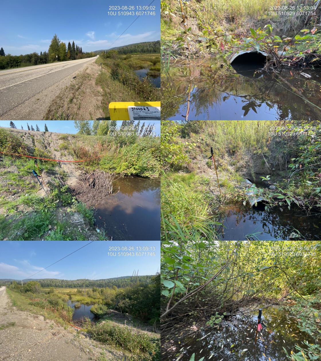 . From top left clockwise: Road/Site Card, Barrel, Outlet, Downstream, Upstream, Inlet.3700023 . From top left clockwise: Road/Site Card, Barrel, Outlet, Downstream, Upstream, Inlet.3700023
|
|||
| Comments: 0.5 m pipe is stuffed inside of the sleeve of a larger older pipe. Beaver trap located at inlet. Burbot have been observed upstream in the past. Inlet almost completely blocked by beaver debris, as well as human placed sticks and beaver trap. Significant road prism erosion on upstream side of pipe as well as immediately adjacent to outlet. Ministry of Transportation chris_culvert_id: 1997085. 13:05:45 |
| Location and Stream Data |
|
Crossing Characteristics | – |
|---|---|---|---|
| Date | 2023-08-26 | Crossing Sub Type | Round Culvert |
| PSCIS ID | 198687 | Diameter (m) | 2 |
| External ID | 3700024 | Length (m) | 26 |
| Crew | AI | Embedded | Yes |
| UTM Zone | 10 | Depth Embedded (m) | 0.25 |
| Easting | 510950.3 | Resemble Channel | Yes |
| Northing | 6072479 | Backwatered | Yes |
| Stream | 42 Mile Creek | Percent Backwatered | 100 |
| Road | Highway 97 | Fill Depth (m) | 1.5 |
| Road Tenure | MOTI | Outlet Drop (m) | 0 |
| Channel Width (m) | 2.5 | Outlet Pool Depth (m) | 0.3 |
| Stream Slope (%) | 1.5 | Inlet Drop | No |
| Beaver Activity | No | Slope (%) | 0.5 |
| Habitat Value | High | Valley Fill | Deep Fill |
| Final score | 11 | Barrier Result | Passable |
| Fix type | – | Fix Span / Diameter | – |
Photos: PSCIS ID 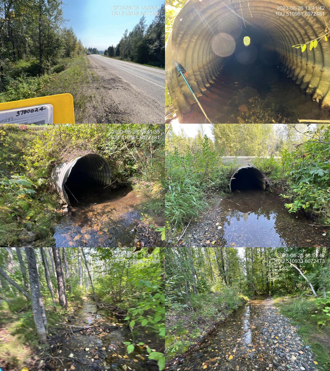 . From top left clockwise: Road/Site Card, Barrel, Outlet, Downstream, Upstream, Inlet.3700024 . From top left clockwise: Road/Site Card, Barrel, Outlet, Downstream, Upstream, Inlet.3700024
|
|||
| Comments: Nice stream with good flow and abundant gravel, suitably sized for spawning. Culvert is 100% backwatered and fully embedded. It appears as though there have been some very high flow events that have moved significant amounts of gravel, substrate, upstream and downstream. See photos. Channel seems overly straight and deep so suspect machine work has been done to dredge out the crossing, upstream and downstream. Ministry of Transportation chris_culvert_id: 1997302. 13:37:33 |
| Location and Stream Data |
|
Crossing Characteristics | – |
|---|---|---|---|
| Date | 2023-08-26 | Crossing Sub Type | Round Culvert |
| PSCIS ID | 198688 | Diameter (m) | 1.5 |
| External ID | 3701948 | Length (m) | 52 |
| Crew | AI | Embedded | No |
| UTM Zone | 10 | Depth Embedded (m) | – |
| Easting | 509646.2 | Resemble Channel | No |
| Northing | 6074531 | Backwatered | No |
| Stream | Tributary to Crooked River | Percent Backwatered | – |
| Road | Highway 97 | Fill Depth (m) | 9.9 |
| Road Tenure | MOTI | Outlet Drop (m) | 0.5 |
| Channel Width (m) | 3.9 | Outlet Pool Depth (m) | 0 |
| Stream Slope (%) | 3 | Inlet Drop | No |
| Beaver Activity | Yes | Slope (%) | 1 |
| Habitat Value | Low | Valley Fill | Deep Fill |
| Final score | 37 | Barrier Result | Barrier |
| Fix type | Replace with New Open Bottom Structure | Fix Span / Diameter | 31 |
Photos: PSCIS ID 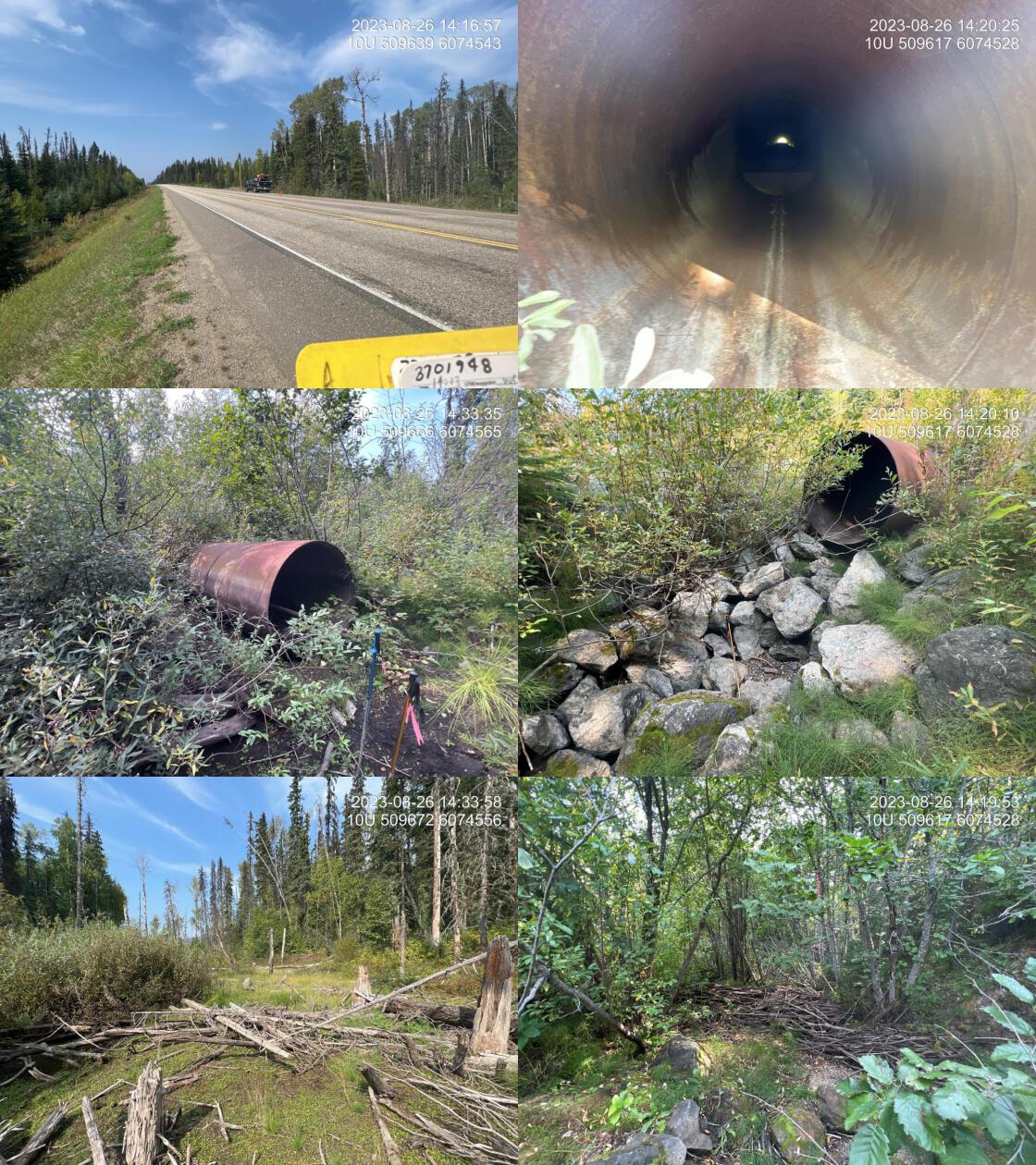 . From top left clockwise: Road/Site Card, Barrel, Outlet, Downstream, Upstream, Inlet.3701948 . From top left clockwise: Road/Site Card, Barrel, Outlet, Downstream, Upstream, Inlet.3701948
|
|||
| Comments: Newly installed horizontally drilled culvert. Stream dry at the time of assessment. Partially vegetated channel upstream, and downstream indicates that the system has not flowed heavily perennially for some time. Wetland type habitat upstream with nice gravels and classic stream character downstream. Baffles installed within the pipe. Approximately 1/3 of the pipe is blocked from beaver debris near inlet. Ministry of Transportation chris_culvert_id: 1997288. 14:12:18 |
| Location and Stream Data |
|
Crossing Characteristics | – |
|---|---|---|---|
| Date | 2023-08-26 | Crossing Sub Type | Round Culvert |
| PSCIS ID | 198689 | Diameter (m) | 1.2 |
| External ID | 2200009 | Length (m) | 30 |
| Crew | AI | Embedded | Yes |
| UTM Zone | 10 | Depth Embedded (m) | 0.1 |
| Easting | 506481.4 | Resemble Channel | Yes |
| Northing | 6080584 | Backwatered | Yes |
| Stream | Tributary to McLeod Lake | Percent Backwatered | 100 |
| Road | Highway 97 | Fill Depth (m) | 1.2 |
| Road Tenure | MOTI | Outlet Drop (m) | 0 |
| Channel Width (m) | 4.1 | Outlet Pool Depth (m) | 1 |
| Stream Slope (%) | 2.5 | Inlet Drop | No |
| Beaver Activity | Yes | Slope (%) | 2.5 |
| Habitat Value | High | Valley Fill | Deep Fill |
| Final score | 22 | Barrier Result | Barrier |
| Fix type | Replace with New Open Bottom Structure | Fix Span / Diameter | 14 |
Photos: PSCIS ID 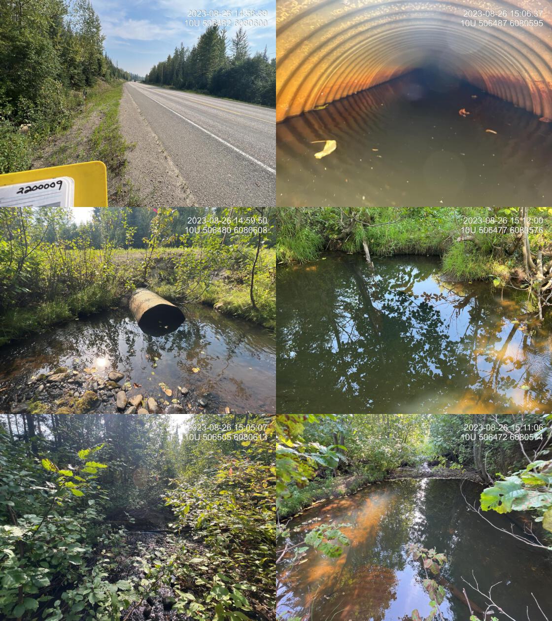 . From top left clockwise: Road/Site Card, Barrel, Outlet, Downstream, Upstream, Inlet.2200009 . From top left clockwise: Road/Site Card, Barrel, Outlet, Downstream, Upstream, Inlet.2200009
|
|||
| Comments: Very nice stream with good flows an abundant gravel. Healthy riparian with evidence of beaver activity, including dam, approximately 5 m downstream of outlet which has backwatered the entire structure, including the outlet of the pipe, which is approximately 10 cm below the surface. It appears as though the crossing has been dredged with a machine recently, both upstream and downstream to deal with substrate deposition. There is pavement armouring the inlet area of the road prism. Ministry of Transportation chris_culvert_id: 1997018. 15:14:21 |
| Location and Stream Data |
|
Crossing Characteristics | – |
|---|---|---|---|
| Date | 2023-08-26 | Crossing Sub Type | Round Culvert |
| PSCIS ID | 198690 | Diameter (m) | 0.9 |
| External ID | 2200012 | Length (m) | 55 |
| Crew | AI | Embedded | No |
| UTM Zone | 10 | Depth Embedded (m) | – |
| Easting | 505029 | Resemble Channel | No |
| Northing | 6083597 | Backwatered | No |
| Stream | Tributary to McLeod lake | Percent Backwatered | – |
| Road | Highway 97 | Fill Depth (m) | 8 |
| Road Tenure | MOTI | Outlet Drop (m) | 0.6 |
| Channel Width (m) | 2.5 | Outlet Pool Depth (m) | 0.1 |
| Stream Slope (%) | 3 | Inlet Drop | No |
| Beaver Activity | No | Slope (%) | 0 |
| Habitat Value | Low | Valley Fill | Deep Fill |
| Final score | 32 | Barrier Result | Barrier |
| Fix type | Replace Structure with Streambed Simulation CBS | Fix Span / Diameter | 4.5 |
Photos: PSCIS ID 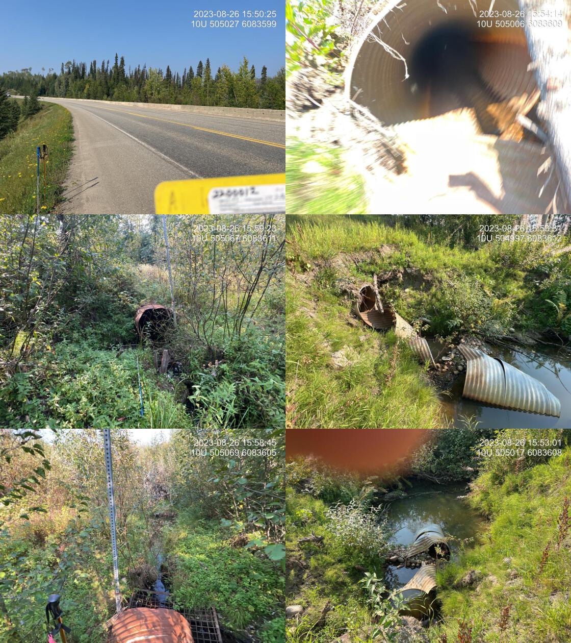 . From top left clockwise: Road/Site Card, Barrel, Outlet, Downstream, Upstream, Inlet.2200012 . From top left clockwise: Road/Site Card, Barrel, Outlet, Downstream, Upstream, Inlet.2200012
|
|||
| Comments: Small stream with extremely long pipe, in very bad shape. End of pipe is unravelling with evidence of machine work at the outlet. Grate on inlet is off of pipe. Appears there has been dredging both upstream and downstream. Large area of clear-cut land upstream. Ministry of Transportation chris_culvert_id: 1997177. 15:50:45 |
| Location and Stream Data |
|
Crossing Characteristics | – |
|---|---|---|---|
| Date | 2023-08-26 | Crossing Sub Type | Round Culvert |
| PSCIS ID | 198691 | Diameter (m) | 0.7 |
| External ID | 3702657 | Length (m) | 14 |
| Crew | AI | Embedded | No |
| UTM Zone | 10 | Depth Embedded (m) | – |
| Easting | 512259.6 | Resemble Channel | No |
| Northing | 6058147 | Backwatered | No |
| Stream | Tributary to Kerry Lake | Percent Backwatered | – |
| Road | Kerry FSR | Fill Depth (m) | 0.5 |
| Road Tenure | MOF 8270 | Outlet Drop (m) | 0.3 |
| Channel Width (m) | 1 | Outlet Pool Depth (m) | 0 |
| Stream Slope (%) | 5 | Inlet Drop | No |
| Beaver Activity | No | Slope (%) | 3 |
| Habitat Value | Low | Valley Fill | Deep Fill |
| Final score | 36 | Barrier Result | Barrier |
| Fix type | Replace Structure with Streambed Simulation CBS | Fix Span / Diameter | 3 |
Photos: PSCIS ID 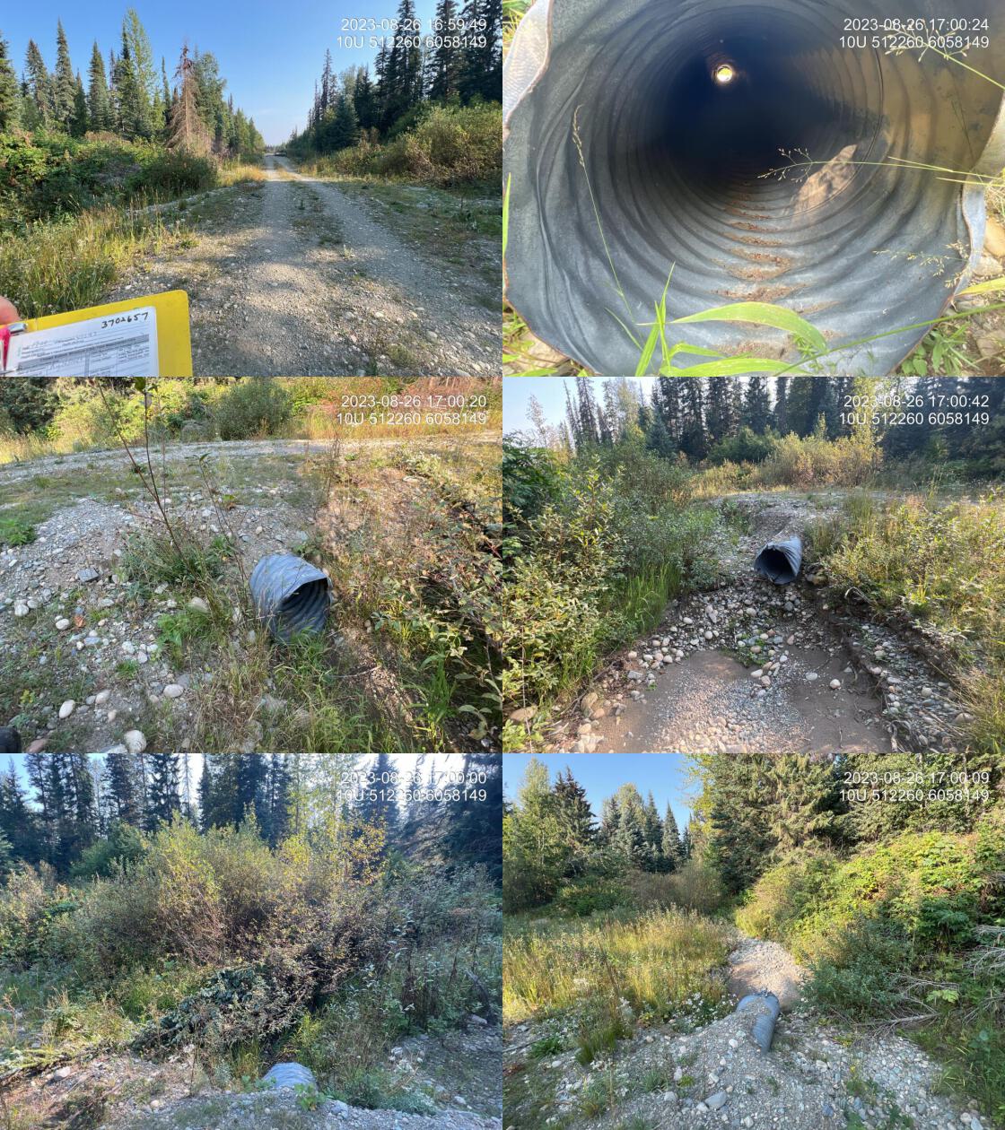 . From top left clockwise: Road/Site Card, Barrel, Outlet, Downstream, Upstream, Inlet.3702657 . From top left clockwise: Road/Site Card, Barrel, Outlet, Downstream, Upstream, Inlet.3702657
|
|||
| Comments: Unlikely a fish bearing stream. Dry at the time of assessment. 17:02:49 |
| Location and Stream Data |
|
Crossing Characteristics | – |
|---|---|---|---|
| Date | 2023-08-26 | Crossing Sub Type | Round Culvert |
| PSCIS ID | 198692 | Diameter (m) | 1.2 |
| External ID | 3702663 | Length (m) | 17 |
| Crew | AI | Embedded | No |
| UTM Zone | 10 | Depth Embedded (m) | – |
| Easting | 511738.8 | Resemble Channel | No |
| Northing | 6059303 | Backwatered | No |
| Stream | Tributary to Kerry Lake | Percent Backwatered | – |
| Road | Kerry FSR | Fill Depth (m) | 4 |
| Road Tenure | MOF 8270 | Outlet Drop (m) | 0.3 |
| Channel Width (m) | 3.6 | Outlet Pool Depth (m) | 1 |
| Stream Slope (%) | 4 | Inlet Drop | No |
| Beaver Activity | No | Slope (%) | 3 |
| Habitat Value | Medium | Valley Fill | Deep Fill |
| Final score | 39 | Barrier Result | Barrier |
| Fix type | Replace with New Open Bottom Structure | Fix Span / Diameter | 13 |
Photos: PSCIS ID 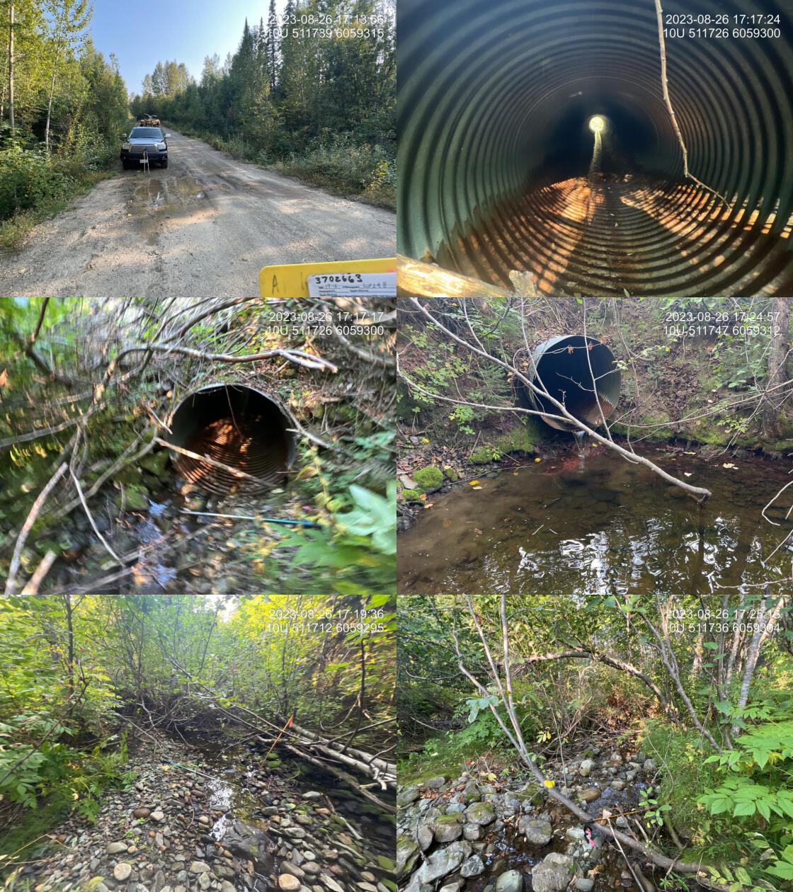 . From top left clockwise: Road/Site Card, Barrel, Outlet, Downstream, Upstream, Inlet.3702663 . From top left clockwise: Road/Site Card, Barrel, Outlet, Downstream, Upstream, Inlet.3702663
|
|||
| Comments: Nice little stream with decent flow for this time of year. Pockets of gravel throughout and healthy shrub and mixed riparian. Fish presence unknown, but seems likely due to proximity to Kerry lake with low gradients. 17:14:13 |
| Location and Stream Data |
|
Crossing Characteristics | – |
|---|---|---|---|
| Date | 2023-08-26 | Crossing Sub Type | Round Culvert |
| PSCIS ID | 198693 | Diameter (m) | 1.2 |
| External ID | 3702665 | Length (m) | 20 |
| Crew | AI | Embedded | No |
| UTM Zone | 10 | Depth Embedded (m) | – |
| Easting | 511840.8 | Resemble Channel | No |
| Northing | 6060225 | Backwatered | No |
| Stream | Tributary to Kerry Lake | Percent Backwatered | – |
| Road | Kerry FSR | Fill Depth (m) | 2 |
| Road Tenure | MOF 8270 | Outlet Drop (m) | 1 |
| Channel Width (m) | 3.5 | Outlet Pool Depth (m) | 0.7 |
| Stream Slope (%) | 3.5 | Inlet Drop | Yes |
| Beaver Activity | No | Slope (%) | 3 |
| Habitat Value | Low | Valley Fill | Deep Fill |
| Final score | 39 | Barrier Result | Barrier |
| Fix type | Replace with New Open Bottom Structure | Fix Span / Diameter | 14 |
Photos: PSCIS ID 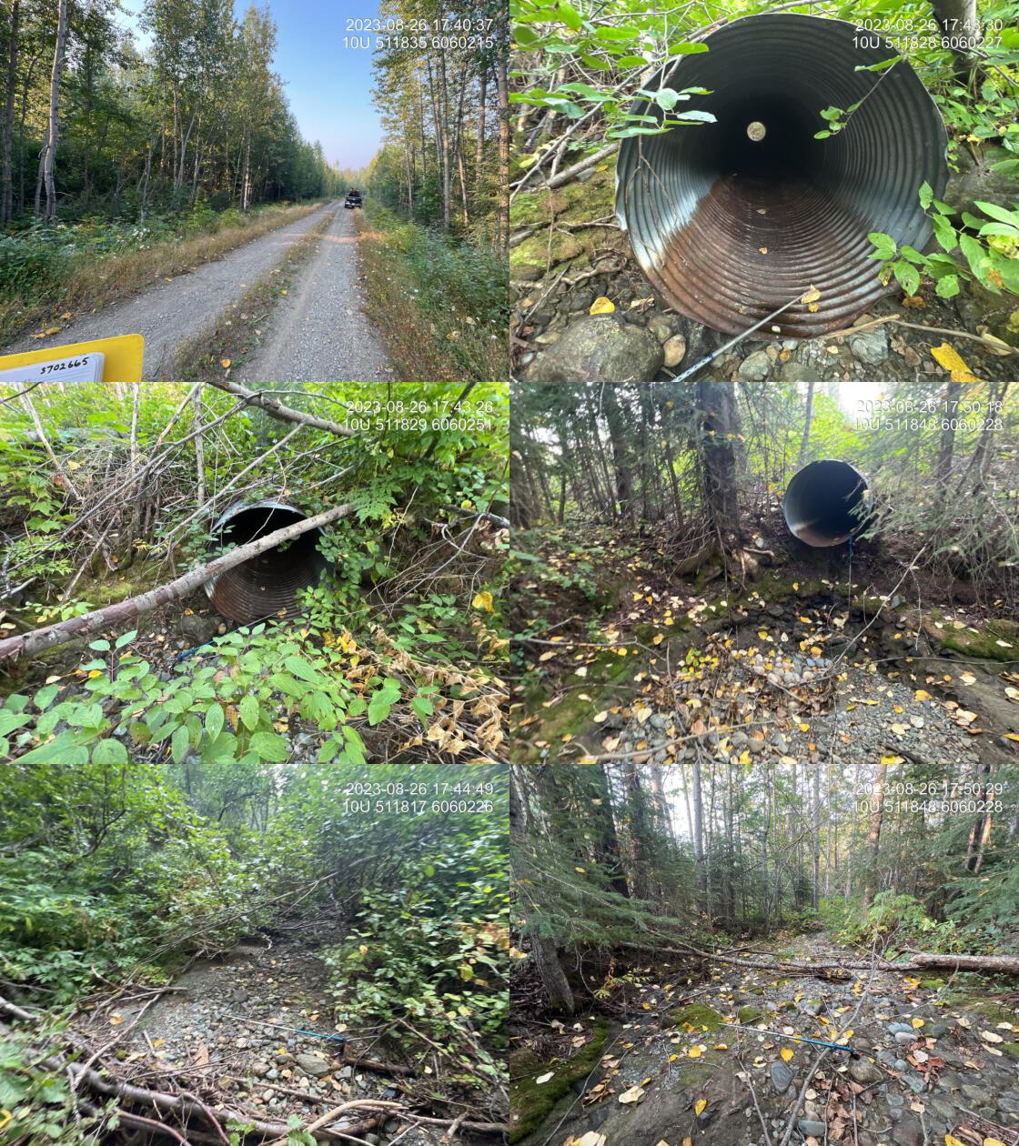 . From top left clockwise: Road/Site Card, Barrel, Outlet, Downstream, Upstream, Inlet.3702665 . From top left clockwise: Road/Site Card, Barrel, Outlet, Downstream, Upstream, Inlet.3702665
|
|||
| Comments: Stream dry at time of survey. Appears to be a fairly large system with abundant gravels present throughout. Estimated 200 to 300 m of lower gradient habitat upstream that could be useful for downstream populations in the spring. Huge outlet drop and very large dry pool indicating pipe is undersized. 17:40:54 |
| Location and Stream Data |
|
Crossing Characteristics | – |
|---|---|---|---|
| Date | 2023-08-29 | Crossing Sub Type | Round Culvert |
| PSCIS ID | 198694 | Diameter (m) | 0.75 |
| External ID | 3703459 | Length (m) | 12 |
| Crew | MW | Embedded | No |
| UTM Zone | 10 | Depth Embedded (m) | – |
| Easting | 513782.8 | Resemble Channel | No |
| Northing | 6067301 | Backwatered | No |
| Stream | Tributary to Altezega Creek | Percent Backwatered | – |
| Road | Firth Lake FSR | Fill Depth (m) | 1.5 |
| Road Tenure | MOF 8385 | Outlet Drop (m) | 0 |
| Channel Width (m) | 2.2 | Outlet Pool Depth (m) | 0.7 |
| Stream Slope (%) | 2 | Inlet Drop | Yes |
| Beaver Activity | No | Slope (%) | 2 |
| Habitat Value | High | Valley Fill | Deep Fill |
| Final score | 21 | Barrier Result | Barrier |
| Fix type | Replace with New Open Bottom Structure | Fix Span / Diameter | 14 |
Photos: PSCIS ID 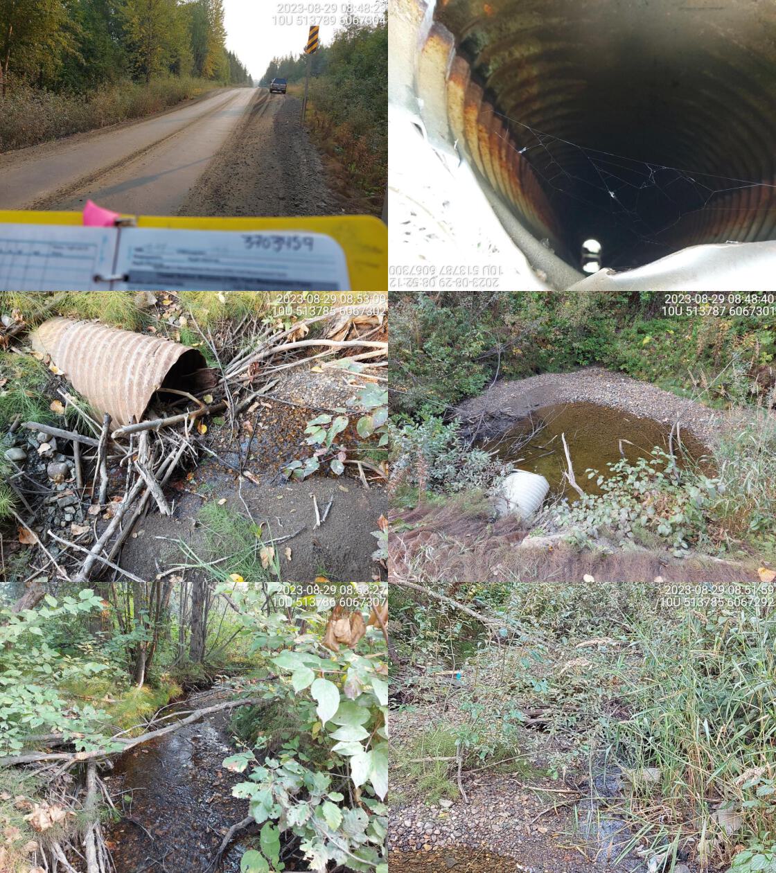 . From top left clockwise: Road/Site Card, Barrel, Outlet, Downstream, Upstream, Inlet.3703459 . From top left clockwise: Road/Site Card, Barrel, Outlet, Downstream, Upstream, Inlet.3703459
|
|||
| Comments: High habitat value upstream. Many fish spotted in outlet pool. Tributary to big system. Culvert old and not in great shape. Needs to be replaced. Debris jam at inlet blocking small section of flow. 08:57:52 |
| Location and Stream Data |
|
Crossing Characteristics | – |
|---|---|---|---|
| Date | 2023-08-29 | Crossing Sub Type | Bridge |
| PSCIS ID | 198695 | Diameter (m) | 15 |
| External ID | 2023082901 | Length (m) | 5 |
| Crew | AI | Embedded | – |
| UTM Zone | 10 | Depth Embedded (m) | – |
| Easting | 513128 | Resemble Channel | – |
| Northing | 6067173 | Backwatered | – |
| Stream | Tributary to Altezega Creek | Percent Backwatered | – |
| Road | Firth Lake FSR | Fill Depth (m) | – |
| Road Tenure | MOF 8385 | Outlet Drop (m) | – |
| Channel Width (m) | – | Outlet Pool Depth (m) | – |
| Stream Slope (%) | – | Inlet Drop | – |
| Beaver Activity | No | Slope (%) | – |
| Habitat Value | – | Valley Fill | – |
| Final score | 0 | Barrier Result | Passable |
| Fix type | – | Fix Span / Diameter | – |
Photos: PSCIS ID 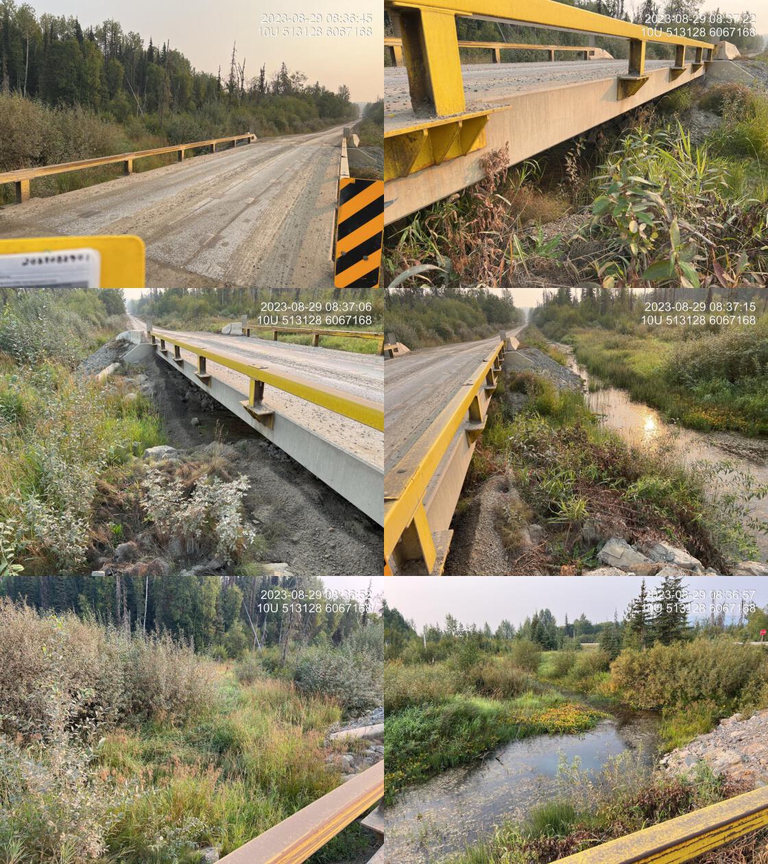 . From top left clockwise: Road/Site Card, Barrel, Outlet, Downstream, Upstream, Inlet.2023082901 . From top left clockwise: Road/Site Card, Barrel, Outlet, Downstream, Upstream, Inlet.2023082901
|
|||
| Comments: Bridge over wetland drainage area. Channel dry at time of assessment. Not a mapped stream but a wetland area upstream of the highway. 08:39:05 |
| Location and Stream Data |
|
Crossing Characteristics | – |
|---|---|---|---|
| Date | 2023-08-30 | Crossing Sub Type | Round Culvert |
| PSCIS ID | 198696 | Diameter (m) | 0.6 |
| External ID | 3702446 | Length (m) | 15 |
| Crew | MW MD | Embedded | No |
| UTM Zone | 10 | Depth Embedded (m) | – |
| Easting | 497845.7 | Resemble Channel | No |
| Northing | 6060884 | Backwatered | No |
| Stream | Tributary to Weedon Lake | Percent Backwatered | – |
| Road | Davie-Weedon Lake FSR | Fill Depth (m) | 2.5 |
| Road Tenure | Canfor R02875 | Outlet Drop (m) | 0.5 |
| Channel Width (m) | 0 | Outlet Pool Depth (m) | 0 |
| Stream Slope (%) | 0 | Inlet Drop | Yes |
| Beaver Activity | No | Slope (%) | 6 |
| Habitat Value | Low | Valley Fill | Deep Fill |
| Final score | 33 | Barrier Result | Barrier |
| Fix type | Replace Structure with Streambed Simulation CBS | Fix Span / Diameter | 3 |
Photos: PSCIS ID 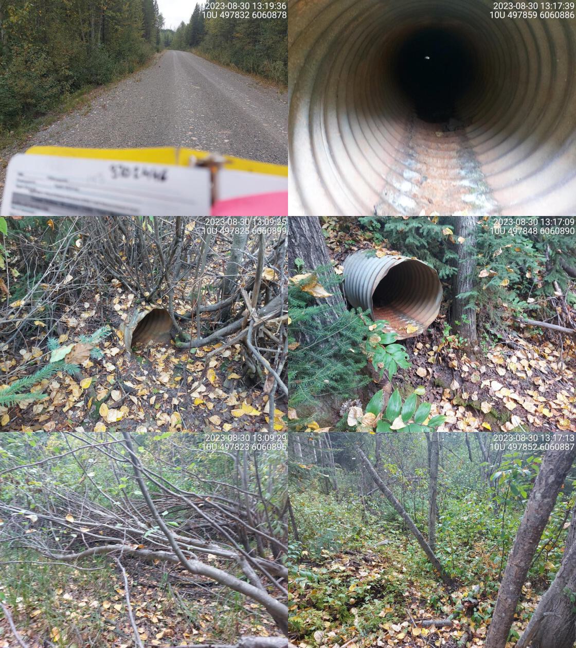 . From top left clockwise: Road/Site Card, Barrel, Outlet, Downstream, Upstream, Inlet.3702446 . From top left clockwise: Road/Site Card, Barrel, Outlet, Downstream, Upstream, Inlet.3702446
|
|||
| Comments: No clear defined channel. Gradient and channel width could not be determined. Dewatered stream. Small, old culvert. 13:07:58 |
| Location and Stream Data |
|
Crossing Characteristics | – |
|---|---|---|---|
| Date | 2023-08-30 | Crossing Sub Type | Round Culvert |
| PSCIS ID | 198697 | Diameter (m) | 1.5 |
| External ID | 3702959 | Length (m) | 12 |
| Crew | MW MD | Embedded | No |
| UTM Zone | 10 | Depth Embedded (m) | – |
| Easting | 494175.8 | Resemble Channel | No |
| Northing | 6055953 | Backwatered | Yes |
| Stream | Tributary to Weedon Creek | Percent Backwatered | 100 |
| Road | Davie-Weedon Lake FSR | Fill Depth (m) | 0.5 |
| Road Tenure | Canfor R01860 | Outlet Drop (m) | 0 |
| Channel Width (m) | 3.4 | Outlet Pool Depth (m) | 1 |
| Stream Slope (%) | 1 | Inlet Drop | No |
| Beaver Activity | Yes | Slope (%) | 1 |
| Habitat Value | Medium | Valley Fill | Deep Fill |
| Final score | 21 | Barrier Result | Barrier |
| Fix type | Replace with New Open Bottom Structure | Fix Span / Diameter | 14 |
Photos: PSCIS ID 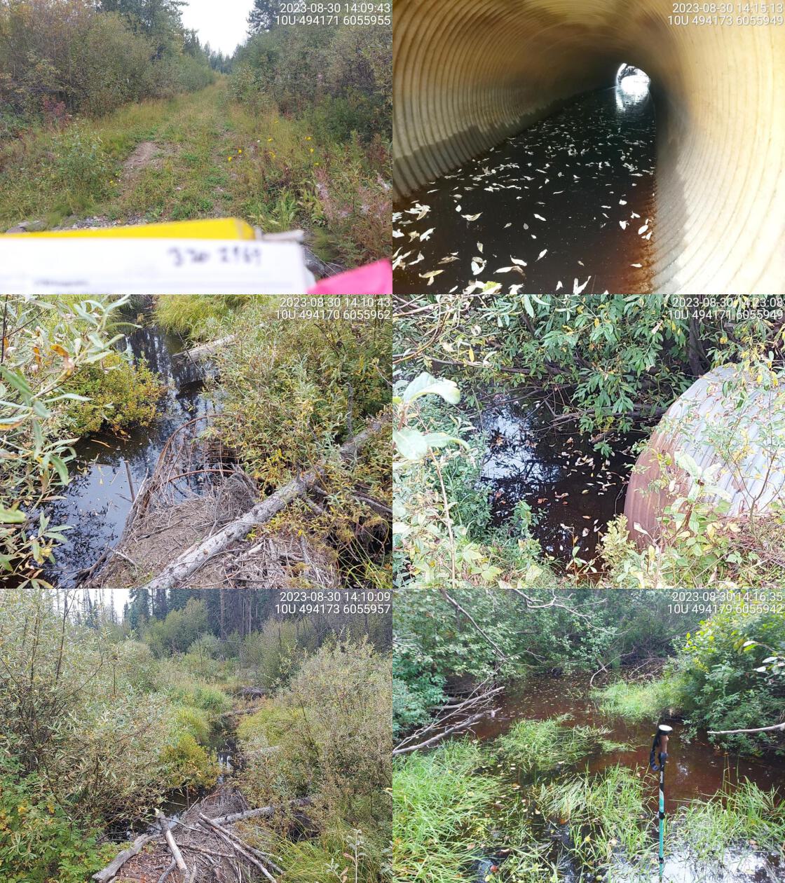 . From top left clockwise: Road/Site Card, Barrel, Outlet, Downstream, Upstream, Inlet.3702959 . From top left clockwise: Road/Site Card, Barrel, Outlet, Downstream, Upstream, Inlet.3702959
|
|||
| Comments: Big beaver dam directly on inlet side, with beaver cage in front of dam (on upstream side). Wetland habitat downstream. Road is caved in on top of culvert. 14:07:02 |
| Location and Stream Data |
|
Crossing Characteristics | – |
|---|---|---|---|
| Date | 2023-08-30 | Crossing Sub Type | Round Culvert |
| PSCIS ID | 198698 | Diameter (m) | 3.5 |
| External ID | 3702445 | Length (m) | 25 |
| Crew | MW MD | Embedded | No |
| UTM Zone | 10 | Depth Embedded (m) | – |
| Easting | 494123.6 | Resemble Channel | No |
| Northing | 6054452 | Backwatered | No |
| Stream | Tributary to Weedon Lake | Percent Backwatered | – |
| Road | Davie-Weedon Lake FSR | Fill Depth (m) | 1 |
| Road Tenure | Canfor R01859 | Outlet Drop (m) | 0.5 |
| Channel Width (m) | 3.5 | Outlet Pool Depth (m) | 0.4 |
| Stream Slope (%) | 1.5 | Inlet Drop | No |
| Beaver Activity | Yes | Slope (%) | 2.5 |
| Habitat Value | Medium | Valley Fill | Deep Fill |
| Final score | 31 | Barrier Result | Barrier |
| Fix type | Replace with New Open Bottom Structure | Fix Span / Diameter | 14 |
Photos: PSCIS ID 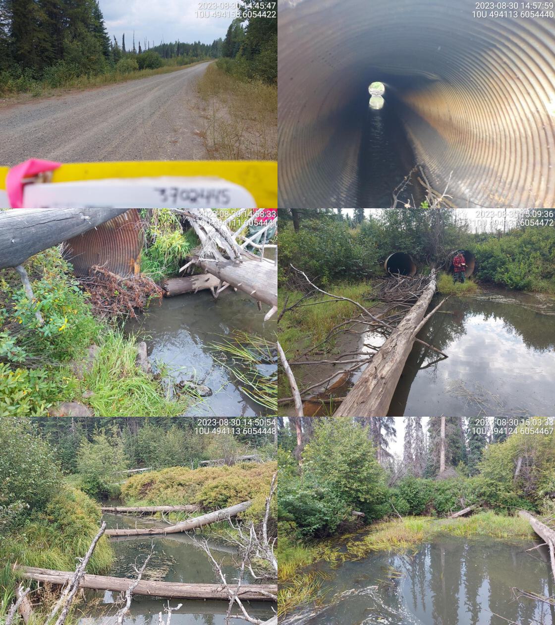 . From top left clockwise: Road/Site Card, Barrel, Outlet, Downstream, Upstream, Inlet.3702445 . From top left clockwise: Road/Site Card, Barrel, Outlet, Downstream, Upstream, Inlet.3702445
|
|||
| Comments: Two culverts of equal length. Debris blockage on inlet side of both pipes. Some flow through culvert. Right culvert is caved in near inlet. 14:48:50 |
| Location and Stream Data |
|
Crossing Characteristics | – |
|---|---|---|---|
| Date | 2023-08-30 | Crossing Sub Type | Round Culvert |
| PSCIS ID | 198699 | Diameter (m) | 0.6 |
| External ID | 3703222 | Length (m) | 15 |
| Crew | MW MD JD BD | Embedded | No |
| UTM Zone | 10 | Depth Embedded (m) | – |
| Easting | 516272.8 | Resemble Channel | No |
| Northing | 6039291 | Backwatered | No |
| Stream | Tributary to Davie Lake | Percent Backwatered | – |
| Road | Davie Lake FSR | Fill Depth (m) | 2 |
| Road Tenure | MOF 7719 | Outlet Drop (m) | 0.6 |
| Channel Width (m) | 2.3 | Outlet Pool Depth (m) | 0.4 |
| Stream Slope (%) | 3.5 | Inlet Drop | No |
| Beaver Activity | No | Slope (%) | 3 |
| Habitat Value | Medium | Valley Fill | Deep Fill |
| Final score | 39 | Barrier Result | Barrier |
| Fix type | Replace with New Open Bottom Structure | Fix Span / Diameter | 14 |
Photos: PSCIS ID 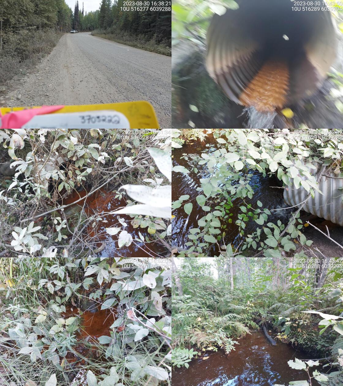 . From top left clockwise: Road/Site Card, Barrel, Outlet, Downstream, Upstream, Inlet.3703222 . From top left clockwise: Road/Site Card, Barrel, Outlet, Downstream, Upstream, Inlet.3703222
|
|||
| Comments: Big outlet drop with big outlet pool. Perched culvert, small, overgrown stream channel. 16:40:11 |
| Location and Stream Data |
|
Crossing Characteristics | – |
|---|---|---|---|
| Date | 2023-08-30 | Crossing Sub Type | Bridge |
| PSCIS ID | 198700 | Diameter (m) | 14 |
| External ID | 24743865 | Length (m) | 3 |
| Crew | MW | Embedded | – |
| UTM Zone | 10 | Depth Embedded (m) | – |
| Easting | 513403.2 | Resemble Channel | – |
| Northing | 6047517 | Backwatered | – |
| Stream | Tributary to Crooked River | Percent Backwatered | – |
| Road | Davie Lake FSR | Fill Depth (m) | – |
| Road Tenure | Winton R02864 | Outlet Drop (m) | – |
| Channel Width (m) | – | Outlet Pool Depth (m) | – |
| Stream Slope (%) | – | Inlet Drop | – |
| Beaver Activity | No | Slope (%) | – |
| Habitat Value | – | Valley Fill | – |
| Final score | 0 | Barrier Result | Passable |
| Fix type | – | Fix Span / Diameter | – |
Photos: PSCIS ID 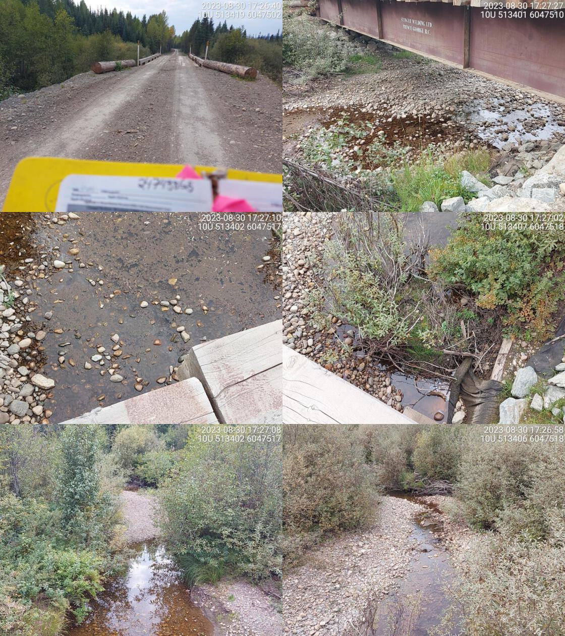 . From top left clockwise: Road/Site Card, Barrel, Outlet, Downstream, Upstream, Inlet.24743865 . From top left clockwise: Road/Site Card, Barrel, Outlet, Downstream, Upstream, Inlet.24743865
|
|||
| Comments: High habitat value. Good flowing stream. 17:28:58 |
| Location and Stream Data |
|
Crossing Characteristics | – |
|---|---|---|---|
| Date | 2023-08-30 | Crossing Sub Type | Round Culvert |
| PSCIS ID | 198701 | Diameter (m) | 0.5 |
| External ID | 3703203 | Length (m) | 15 |
| Crew | MW | Embedded | No |
| UTM Zone | 10 | Depth Embedded (m) | – |
| Easting | 514487 | Resemble Channel | No |
| Northing | 6042441 | Backwatered | No |
| Stream | Tributary to Davie Lake | Percent Backwatered | – |
| Road | Davie Lake FSR | Fill Depth (m) | 3.5 |
| Road Tenure | MOF 7719 | Outlet Drop (m) | 0 |
| Channel Width (m) | 1.2 | Outlet Pool Depth (m) | 0 |
| Stream Slope (%) | 1 | Inlet Drop | No |
| Beaver Activity | No | Slope (%) | 3 |
| Habitat Value | Low | Valley Fill | Deep Fill |
| Final score | 29 | Barrier Result | Barrier |
| Fix type | Replace Structure with Streambed Simulation CBS | Fix Span / Diameter | 3 |
Photos: PSCIS ID 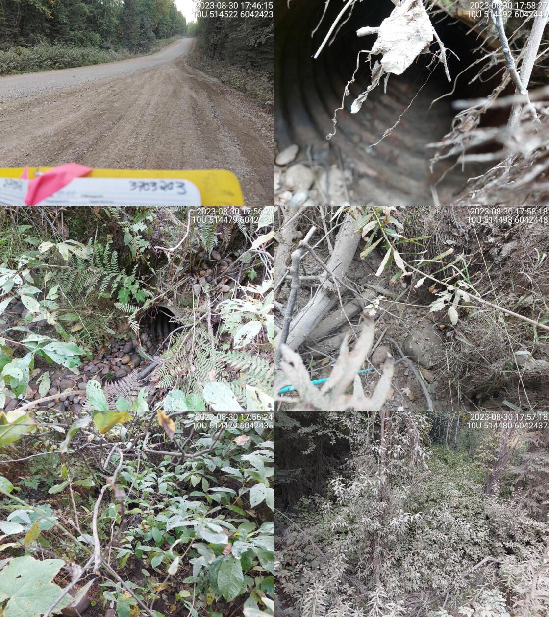 . From top left clockwise: Road/Site Card, Barrel, Outlet, Downstream, Upstream, Inlet.3703203 . From top left clockwise: Road/Site Card, Barrel, Outlet, Downstream, Upstream, Inlet.3703203
|
|||
| Comments: Dewatered channel. Very overgrown and no clear channel. Channel width and gradient estimated. 17:53:54 |
| Location and Stream Data |
|
Crossing Characteristics | – |
|---|---|---|---|
| Date | 2023-08-30 | Crossing Sub Type | Round Culvert |
| PSCIS ID | 198702 | Diameter (m) | 1 |
| External ID | 2200301 | Length (m) | 26 |
| Crew | AI JD TS BP | Embedded | No |
| UTM Zone | 10 | Depth Embedded (m) | – |
| Easting | 490978.8 | Resemble Channel | No |
| Northing | 6075927 | Backwatered | No |
| Stream | Tributary to Hammett Creek | Percent Backwatered | – |
| Road | Carp Lake FSR | Fill Depth (m) | 2.5 |
| Road Tenure | Canfor R01860 | Outlet Drop (m) | 0.55 |
| Channel Width (m) | 3 | Outlet Pool Depth (m) | 0.6 |
| Stream Slope (%) | 1.5 | Inlet Drop | No |
| Beaver Activity | No | Slope (%) | 4 |
| Habitat Value | Medium | Valley Fill | Deep Fill |
| Final score | 39 | Barrier Result | Barrier |
| Fix type | Replace with New Open Bottom Structure | Fix Span / Diameter | 14 |
Photos: PSCIS ID 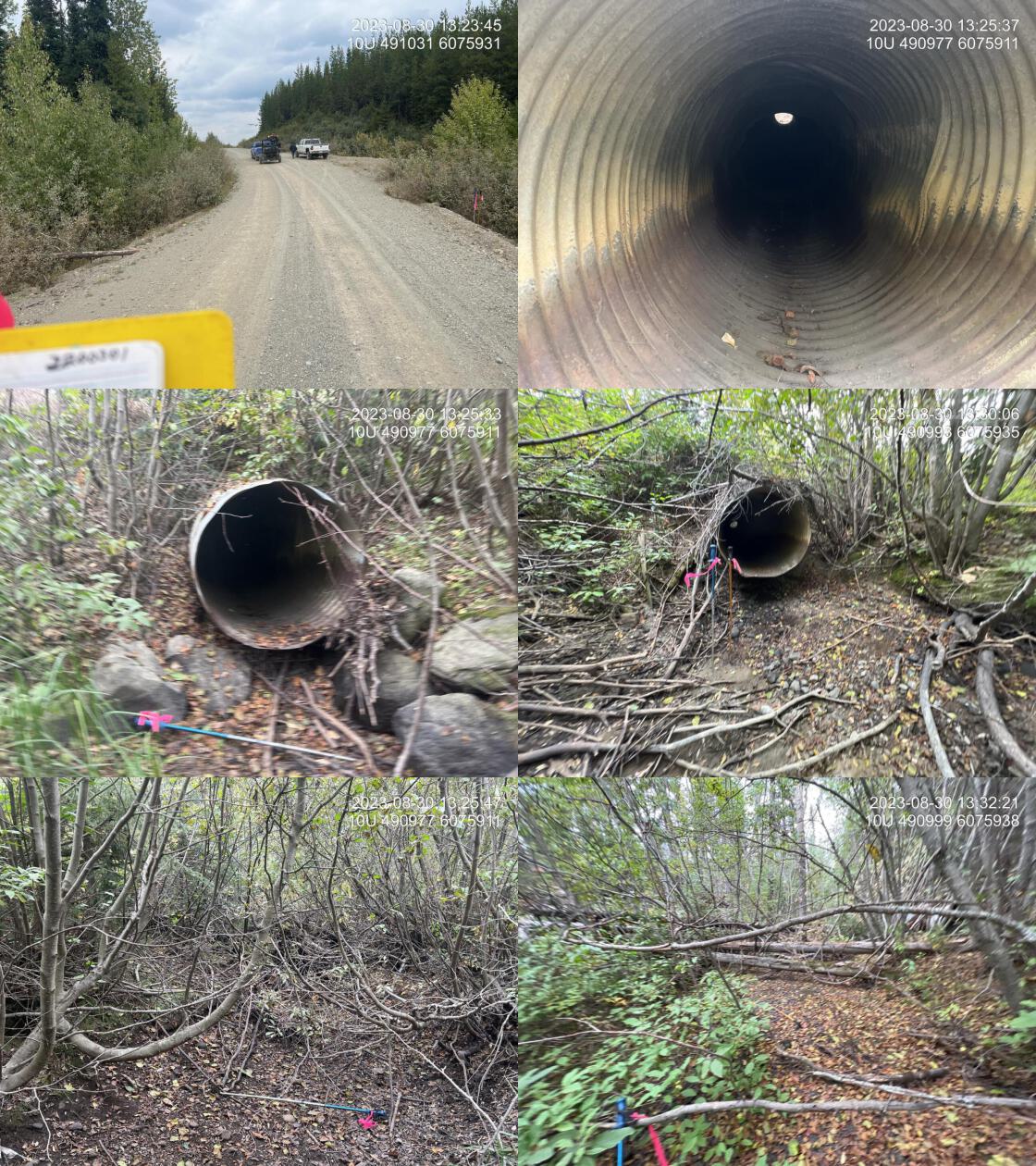 . From top left clockwise: Road/Site Card, Barrel, Outlet, Downstream, Upstream, Inlet.2200301 . From top left clockwise: Road/Site Card, Barrel, Outlet, Downstream, Upstream, Inlet.2200301
|
|||
| Comments: Stream dry at the time of assessment. This is a larger system during runoff with abundant gravels present suitable for rainbow spawning. Old pipe located downstream of the crossing proximately 20 m. Healthy riparian mixed forest. 13:18:06 |
| Location and Stream Data |
|
Crossing Characteristics | – |
|---|---|---|---|
| Date | 2023-08-30 | Crossing Sub Type | Ford |
| PSCIS ID | 198703 | Diameter (m) | – |
| External ID | 2201739 | Length (m) | – |
| Crew | Al | Embedded | – |
| UTM Zone | 10 | Depth Embedded (m) | – |
| Easting | 491687.3 | Resemble Channel | – |
| Northing | 6075171 | Backwatered | – |
| Stream | Tributary to Hammett Creek | Percent Backwatered | – |
| Road | Carp Lake FSR | Fill Depth (m) | – |
| Road Tenure | Canfor R01860 | Outlet Drop (m) | – |
| Channel Width (m) | – | Outlet Pool Depth (m) | – |
| Stream Slope (%) | – | Inlet Drop | – |
| Beaver Activity | No | Slope (%) | – |
| Habitat Value | – | Valley Fill | – |
| Final score | 0 | Barrier Result | Unknown |
| Fix type | – | Fix Span / Diameter | – |
Photos: PSCIS ID 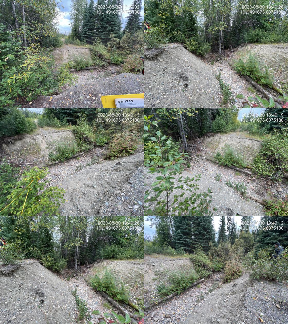 . From top left clockwise: Road/Site Card, Barrel, Outlet, Downstream, Upstream, Inlet.2201739 . From top left clockwise: Road/Site Card, Barrel, Outlet, Downstream, Upstream, Inlet.2201739
|
|||
| Comments: Ford. Deep deactivation will block all ATV access. 13:47:04 |
| Location and Stream Data |
|
Crossing Characteristics | – |
|---|---|---|---|
| Date | 2023-08-30 | Crossing Sub Type | Round Culvert |
| PSCIS ID | 198704 | Diameter (m) | 1.2 |
| External ID | 2200987 | Length (m) | 22 |
| Crew | AI | Embedded | No |
| UTM Zone | 10 | Depth Embedded (m) | – |
| Easting | 491638.9 | Resemble Channel | No |
| Northing | 6072901 | Backwatered | No |
| Stream | Tributary to Hammett Creek | Percent Backwatered | – |
| Road | Davie-War FSR | Fill Depth (m) | 2 |
| Road Tenure | Canfor R01860 | Outlet Drop (m) | 0 |
| Channel Width (m) | 1 | Outlet Pool Depth (m) | 0 |
| Stream Slope (%) | 5.5 | Inlet Drop | Yes |
| Beaver Activity | No | Slope (%) | 4 |
| Habitat Value | Low | Valley Fill | Deep Fill |
| Final score | 23 | Barrier Result | Barrier |
| Fix type | Replace Structure with Streambed Simulation CBS | Fix Span / Diameter | 3 |
Photos: PSCIS ID 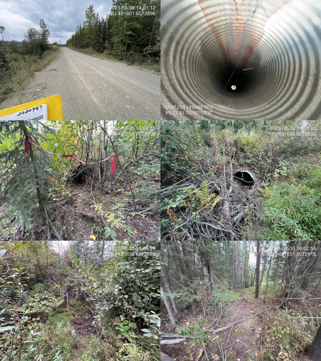 . From top left clockwise: Road/Site Card, Barrel, Outlet, Downstream, Upstream, Inlet.2200987 . From top left clockwise: Road/Site Card, Barrel, Outlet, Downstream, Upstream, Inlet.2200987
|
|||
| Comments: Small stream with dry, mostly vegetated channel indicating stream rarely flows. Very unlikely that fish try to access upstream of the road. 14:08:49 |
| Location and Stream Data |
|
Crossing Characteristics | – |
|---|---|---|---|
| Date | 2023-08-30 | Crossing Sub Type | Ford |
| PSCIS ID | 198705 | Diameter (m) | – |
| External ID | 3702614 | Length (m) | – |
| Crew | AI TS | Embedded | – |
| UTM Zone | 10 | Depth Embedded (m) | – |
| Easting | 496782.7 | Resemble Channel | – |
| Northing | 6054763 | Backwatered | – |
| Stream | Tributary to Weedon Lake | Percent Backwatered | – |
| Road | Davie-Weedon Lake FSR | Fill Depth (m) | – |
| Road Tenure | Winton R02864 | Outlet Drop (m) | – |
| Channel Width (m) | – | Outlet Pool Depth (m) | – |
| Stream Slope (%) | – | Inlet Drop | – |
| Beaver Activity | No | Slope (%) | – |
| Habitat Value | – | Valley Fill | – |
| Final score | 0 | Barrier Result | Unknown |
| Fix type | – | Fix Span / Diameter | – |
Photos: PSCIS ID 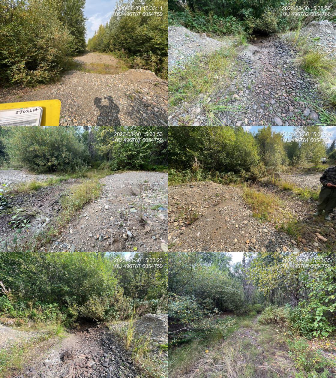 . From top left clockwise: Road/Site Card, Barrel, Outlet, Downstream, Upstream, Inlet.3702614 . From top left clockwise: Road/Site Card, Barrel, Outlet, Downstream, Upstream, Inlet.3702614
|
|||
| Comments: Ford. Deactivated road with ATV drive around. 15:39:47 |
| Location and Stream Data |
|
Crossing Characteristics | – |
|---|---|---|---|
| Date | 2023-08-30 | Crossing Sub Type | Round Culvert |
| PSCIS ID | 198706 | Diameter (m) | 1.75 |
| External ID | 3702455 | Length (m) | 55 |
| Crew | AI | Embedded | No |
| UTM Zone | 10 | Depth Embedded (m) | – |
| Easting | 495632.4 | Resemble Channel | No |
| Northing | 6051512 | Backwatered | No |
| Stream | Tributary to Weedon Lake | Percent Backwatered | – |
| Road | David-Weedon Lake FSR | Fill Depth (m) | 5 |
| Road Tenure | Winton R02864 | Outlet Drop (m) | 0.25 |
| Channel Width (m) | 10 | Outlet Pool Depth (m) | 0.4 |
| Stream Slope (%) | 0 | Inlet Drop | Yes |
| Beaver Activity | Yes | Slope (%) | 0 |
| Habitat Value | Medium | Valley Fill | Deep Fill |
| Final score | 27 | Barrier Result | Barrier |
| Fix type | Replace with New Open Bottom Structure | Fix Span / Diameter | 16 |
Photos: PSCIS ID 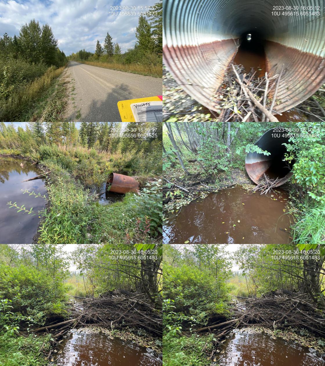 . From top left clockwise: Road/Site Card, Barrel, Outlet, Downstream, Upstream, Inlet.3702455 . From top left clockwise: Road/Site Card, Barrel, Outlet, Downstream, Upstream, Inlet.3702455
|
|||
| Comments: Large wetland areas, upstream and downstream. Culvert appears to have settled in the middle with raised inlet and outlet. Beaverdam over 1 m high located just upstream of inlet. 16:05:32 |
| Location and Stream Data |
|
Crossing Characteristics | – |
|---|---|---|---|
| Date | 2023-08-30 | Crossing Sub Type | Bridge |
| PSCIS ID | 198707 | Diameter (m) | 13 |
| External ID | 3700783 | Length (m) | 5 |
| Crew | AI | Embedded | – |
| UTM Zone | 10 | Depth Embedded (m) | – |
| Easting | 512463.2 | Resemble Channel | – |
| Northing | 6047487 | Backwatered | – |
| Stream | Tributary to Crooked River | Percent Backwatered | – |
| Road | Davie Lake FSR | Fill Depth (m) | – |
| Road Tenure | Winton R02864 | Outlet Drop (m) | – |
| Channel Width (m) | – | Outlet Pool Depth (m) | – |
| Stream Slope (%) | – | Inlet Drop | – |
| Beaver Activity | No | Slope (%) | – |
| Habitat Value | – | Valley Fill | – |
| Final score | 0 | Barrier Result | Passable |
| Fix type | – | Fix Span / Diameter | – |
Photos: PSCIS ID 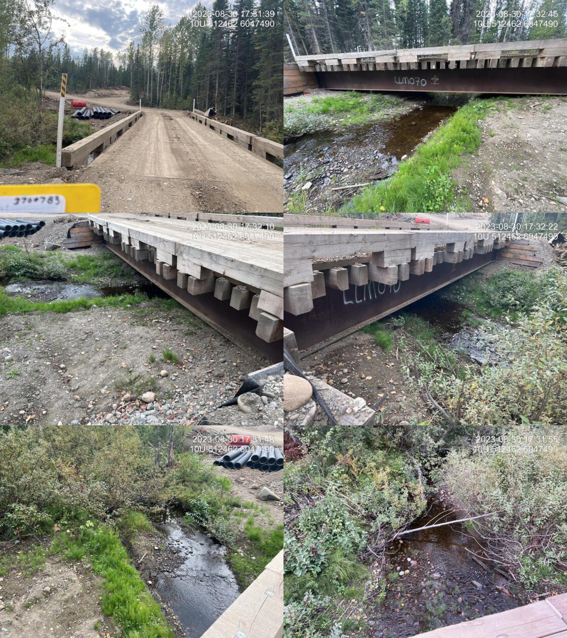 . From top left clockwise: Road/Site Card, Barrel, Outlet, Downstream, Upstream, Inlet.3700783 . From top left clockwise: Road/Site Card, Barrel, Outlet, Downstream, Upstream, Inlet.3700783
|
|||
| Comments: Good flowing stream with abundant gravels. 17:30:20 |
| Location and Stream Data |
|
Crossing Characteristics | – |
|---|---|---|---|
| Date | 2023-08-30 | Crossing Sub Type | Round Culvert |
| PSCIS ID | 198708 | Diameter (m) | 1 |
| External ID | 3703210 | Length (m) | 13 |
| Crew | AI | Embedded | No |
| UTM Zone | 10 | Depth Embedded (m) | – |
| Easting | 515195.7 | Resemble Channel | No |
| Northing | 6040682 | Backwatered | No |
| Stream | Tributary to Davie Lake | Percent Backwatered | – |
| Road | David Lake FSR | Fill Depth (m) | 1 |
| Road Tenure | MOF 7719 | Outlet Drop (m) | 0 |
| Channel Width (m) | 2.4 | Outlet Pool Depth (m) | 0.3 |
| Stream Slope (%) | 0.5 | Inlet Drop | No |
| Beaver Activity | No | Slope (%) | 1.5 |
| Habitat Value | Medium | Valley Fill | Deep Fill |
| Final score | 21 | Barrier Result | Barrier |
| Fix type | Replace with New Open Bottom Structure | Fix Span / Diameter | 14 |
Photos: PSCIS ID 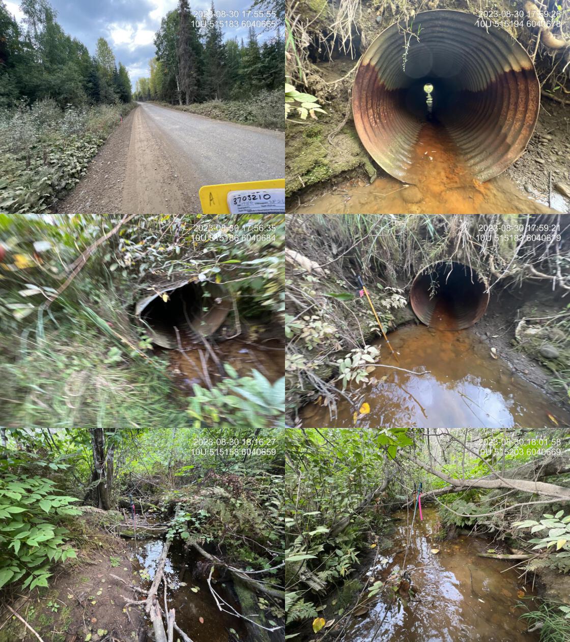 . From top left clockwise: Road/Site Card, Barrel, Outlet, Downstream, Upstream, Inlet.3703210 . From top left clockwise: Road/Site Card, Barrel, Outlet, Downstream, Upstream, Inlet.3703210
|
|||
| Comments: Abundant gravel downstream. Minimal flow but channel is well defined indicating it flows for most of the year. Crossing modelled as just upstream a couple hundred metres does not exist, and should be entered into bcfishpass. 17:53:50 |
| Location and Stream Data |
|
Crossing Characteristics | – |
|---|---|---|---|
| Date | 2023-08-31 | Crossing Sub Type | Round Culvert |
| PSCIS ID | 198709 | Diameter (m) | 3.6 |
| External ID | 3703209 | Length (m) | 12 |
| Crew | MW TS JD BP | Embedded | No |
| UTM Zone | 10 | Depth Embedded (m) | – |
| Easting | 518240.9 | Resemble Channel | No |
| Northing | 6034399 | Backwatered | No |
| Stream | Tributary to Crooked River | Percent Backwatered | – |
| Road | Davie Lake FSR | Fill Depth (m) | 0.6 |
| Road Tenure | MOF 7719 | Outlet Drop (m) | 0 |
| Channel Width (m) | 4 | Outlet Pool Depth (m) | 0 |
| Stream Slope (%) | 1.5 | Inlet Drop | No |
| Beaver Activity | No | Slope (%) | 2 |
| Habitat Value | Low | Valley Fill | Deep Fill |
| Final score | 18 | Barrier Result | Potential |
| Fix type | Replace with New Open Bottom Structure | Fix Span / Diameter | 14 |
Photos: PSCIS ID 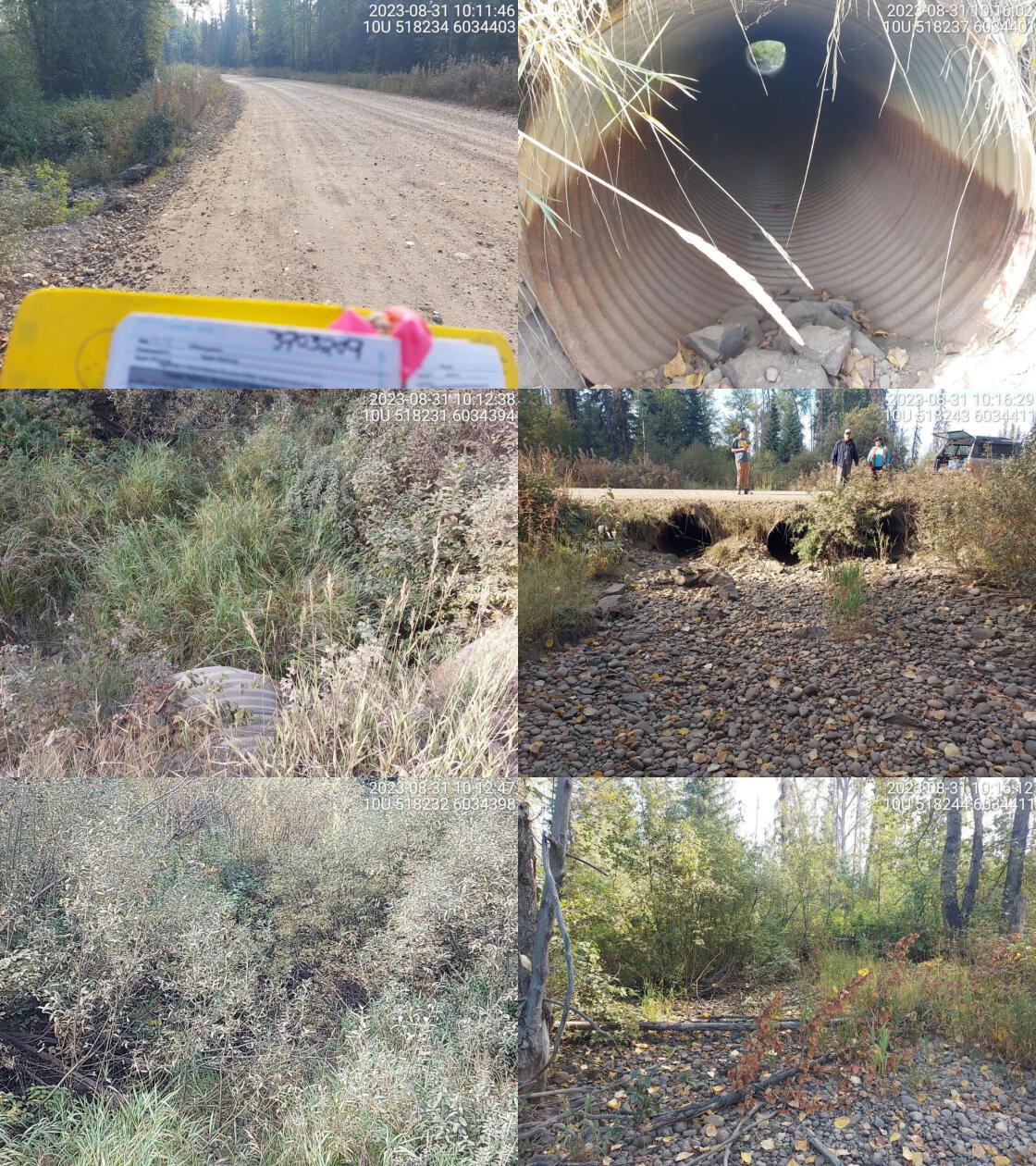 . From top left clockwise: Road/Site Card, Barrel, Outlet, Downstream, Upstream, Inlet.3703209 . From top left clockwise: Road/Site Card, Barrel, Outlet, Downstream, Upstream, Inlet.3703209
|
|||
| Comments: Three pipes. Stream is completely dewatered. No water flowing through culvert. Culvert diameter totaled between three. 10:20:43 |
| Location and Stream Data |
|
Crossing Characteristics | – |
|---|---|---|---|
| Date | 2023-08-31 | Crossing Sub Type | Bridge |
| PSCIS ID | 198710 | Diameter (m) | 19.6 |
| External ID | 2200799 | Length (m) | 4 |
| Crew | MW TS JD BP | Embedded | – |
| UTM Zone | 10 | Depth Embedded (m) | – |
| Easting | 499080.3 | Resemble Channel | – |
| Northing | 6094095 | Backwatered | – |
| Stream | Tributary to McLeod Lake | Percent Backwatered | – |
| Road | Spur | Fill Depth (m) | – |
| Road Tenure | Unclassified | Outlet Drop (m) | – |
| Channel Width (m) | – | Outlet Pool Depth (m) | – |
| Stream Slope (%) | – | Inlet Drop | – |
| Beaver Activity | No | Slope (%) | – |
| Habitat Value | – | Valley Fill | – |
| Final score | 0 | Barrier Result | Passable |
| Fix type | – | Fix Span / Diameter | – |
Photos: PSCIS ID 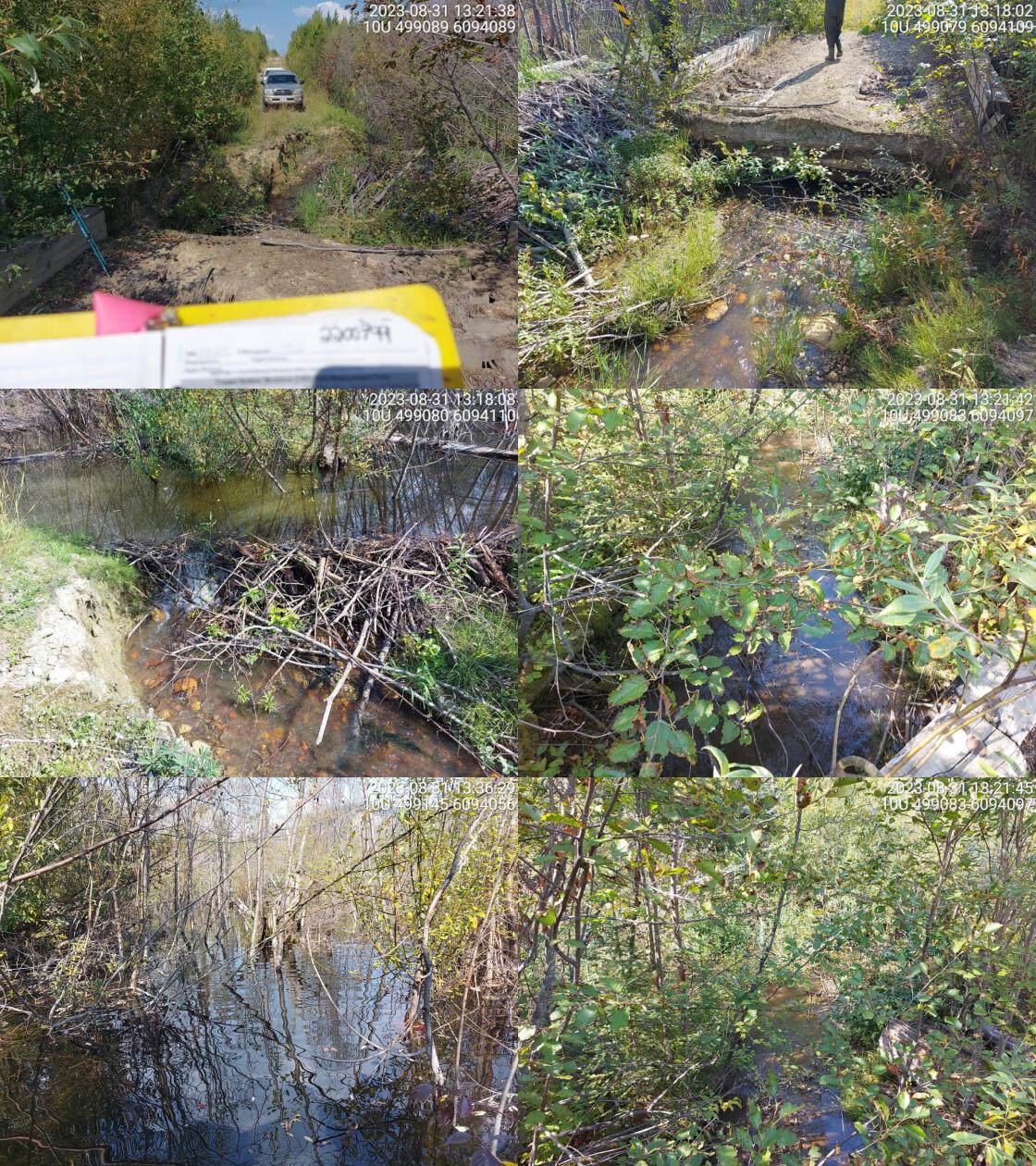 . From top left clockwise: Road/Site Card, Barrel, Outlet, Downstream, Upstream, Inlet.2200799 . From top left clockwise: Road/Site Card, Barrel, Outlet, Downstream, Upstream, Inlet.2200799
|
|||
| Comments: Huge beaver wetland complex just upstream of crossing. Dams on both sides of crossing. Old bridge that is separated in the middle, impassable by vehicle. 14:09:51 |
| Location and Stream Data |
|
Crossing Characteristics | – |
|---|---|---|---|
| Date | 2023-08-31 | Crossing Sub Type | Round Culvert |
| PSCIS ID | 198711 | Diameter (m) | 1.75 |
| External ID | 3702919 | Length (m) | 30 |
| Crew | AI MD | Embedded | No |
| UTM Zone | 10 | Depth Embedded (m) | – |
| Easting | 509951.7 | Resemble Channel | No |
| Northing | 6040984 | Backwatered | No |
| Stream | Tributary to Crooked River | Percent Backwatered | – |
| Road | Davie-Muskeg FSR | Fill Depth (m) | 4 |
| Road Tenure | Winton R02864 | Outlet Drop (m) | 1.1 |
| Channel Width (m) | 4.3 | Outlet Pool Depth (m) | 0.65 |
| Stream Slope (%) | 2.5 | Inlet Drop | Yes |
| Beaver Activity | No | Slope (%) | 3 |
| Habitat Value | Medium | Valley Fill | Deep Fill |
| Final score | 42 | Barrier Result | Barrier |
| Fix type | Replace with New Open Bottom Structure | Fix Span / Diameter | 13 |
Photos: PSCIS ID 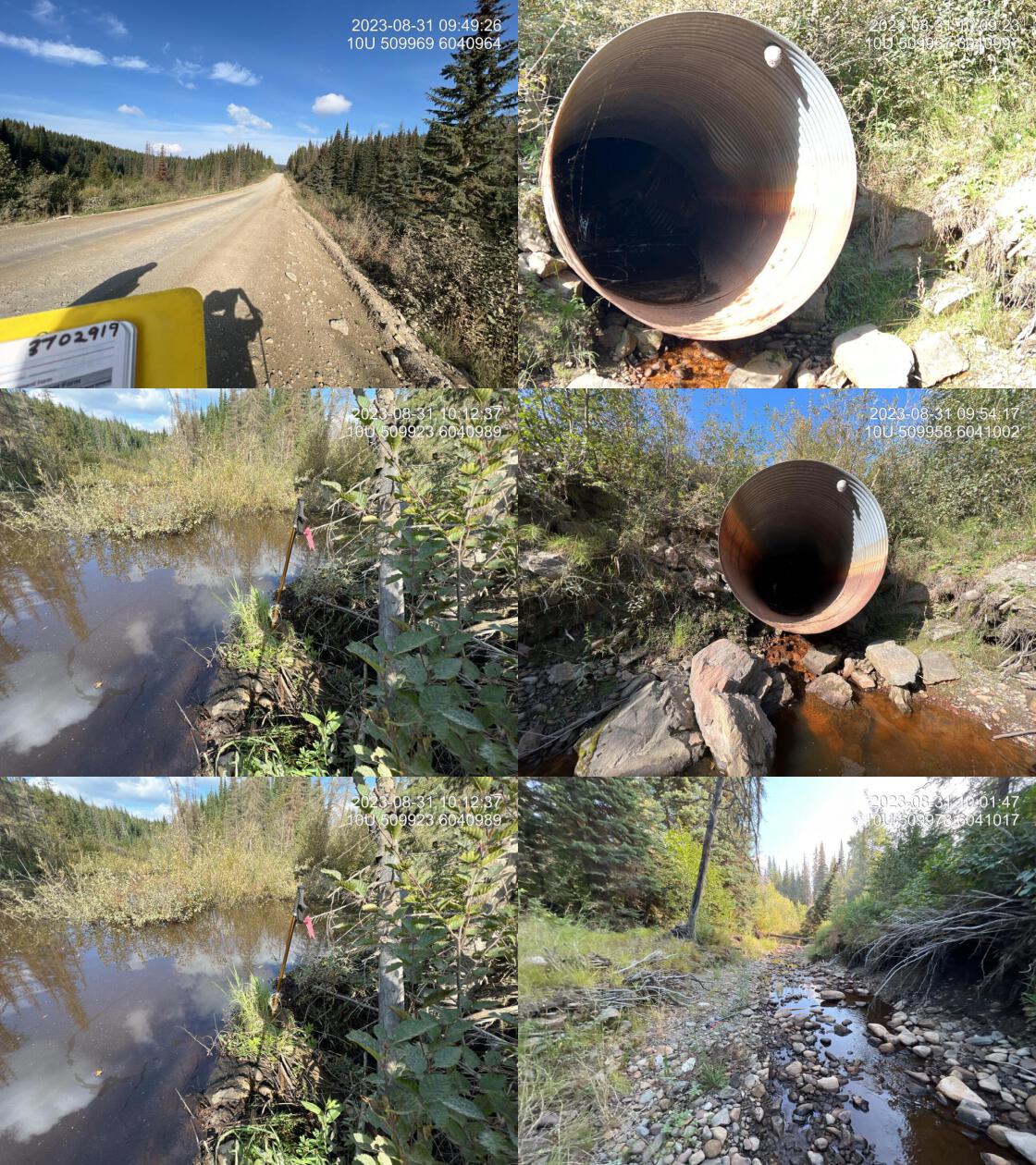 . From top left clockwise: Road/Site Card, Barrel, Outlet, Downstream, Upstream, Inlet.3702919 . From top left clockwise: Road/Site Card, Barrel, Outlet, Downstream, Upstream, Inlet.3702919
|
|||
| Comments: Surprisingly large drainage with good flow. Huge outlet drop and pipe is in very bad shape. Extra 3 m of culvert has been added to the downstream side and is sloping the opposite direction to draining. Large amounts of algae in the channel downstream. Massive amounts of erosion in the downstream channel indicating there are very high flows during runoff. Upstream side of pipe is completely blocked by a beaver dam, creating a wetland upstream. 09:51:08 |
| Location and Stream Data |
|
Crossing Characteristics | – |
|---|---|---|---|
| Date | 2023-08-31 | Crossing Sub Type | Round Culvert |
| PSCIS ID | 198712 | Diameter (m) | 1.75 |
| External ID | 3702923 | Length (m) | 43 |
| Crew | Al MD | Embedded | No |
| UTM Zone | 10 | Depth Embedded (m) | – |
| Easting | 510785 | Resemble Channel | No |
| Northing | 6040578 | Backwatered | No |
| Stream | Tributary to Crooked River | Percent Backwatered | – |
| Road | Davie-Muskeg FSR | Fill Depth (m) | 9 |
| Road Tenure | Winton R02864 | Outlet Drop (m) | 0.4 |
| Channel Width (m) | 2.7 | Outlet Pool Depth (m) | 0.63 |
| Stream Slope (%) | 2 | Inlet Drop | No |
| Beaver Activity | No | Slope (%) | 3 |
| Habitat Value | Medium | Valley Fill | Deep Fill |
| Final score | 42 | Barrier Result | Barrier |
| Fix type | Replace Structure with Streambed Simulation CBS | Fix Span / Diameter | 4.5 |
Photos: PSCIS ID 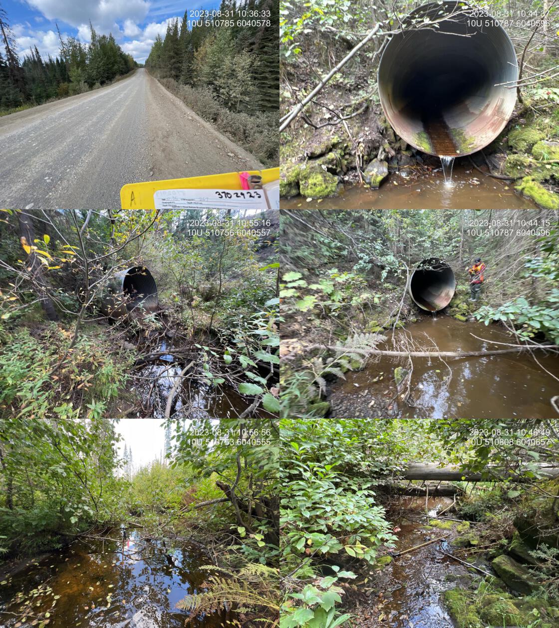 . From top left clockwise: Road/Site Card, Barrel, Outlet, Downstream, Upstream, Inlet.3702923 . From top left clockwise: Road/Site Card, Barrel, Outlet, Downstream, Upstream, Inlet.3702923
|
|||
| Comments: Pipe is in extremely bad condition. There are collapsed sections at the edge of the road prism both upstream and downstream. The inlet of the pipe is elevated well above the stream surface as the centre of the pipe has been pressed down by the road fill overtime. Lots of flow must be going underneath the pipe. Large system with decent flow. Some gravels suitable for spawning downstream. 10:35:13 |
| Location and Stream Data |
|
Crossing Characteristics | – |
|---|---|---|---|
| Date | 2023-08-31 | Crossing Sub Type | Round Culvert |
| PSCIS ID | 198713 | Diameter (m) | 2.1 |
| External ID | 3702924 | Length (m) | 47 |
| Crew | AI MD | Embedded | No |
| UTM Zone | 10 | Depth Embedded (m) | – |
| Easting | 511000.5 | Resemble Channel | No |
| Northing | 6040479 | Backwatered | No |
| Stream | Tributary to Crooked River | Percent Backwatered | – |
| Road | Davie-Muskeg FSR | Fill Depth (m) | 9 |
| Road Tenure | Winton R02864 | Outlet Drop (m) | 0.2 |
| Channel Width (m) | 3.4 | Outlet Pool Depth (m) | 0.3 |
| Stream Slope (%) | 2 | Inlet Drop | No |
| Beaver Activity | No | Slope (%) | 3 |
| Habitat Value | Medium | Valley Fill | Deep Fill |
| Final score | 37 | Barrier Result | Barrier |
| Fix type | Replace Structure with Streambed Simulation CBS | Fix Span / Diameter | 4.5 |
Photos: PSCIS ID 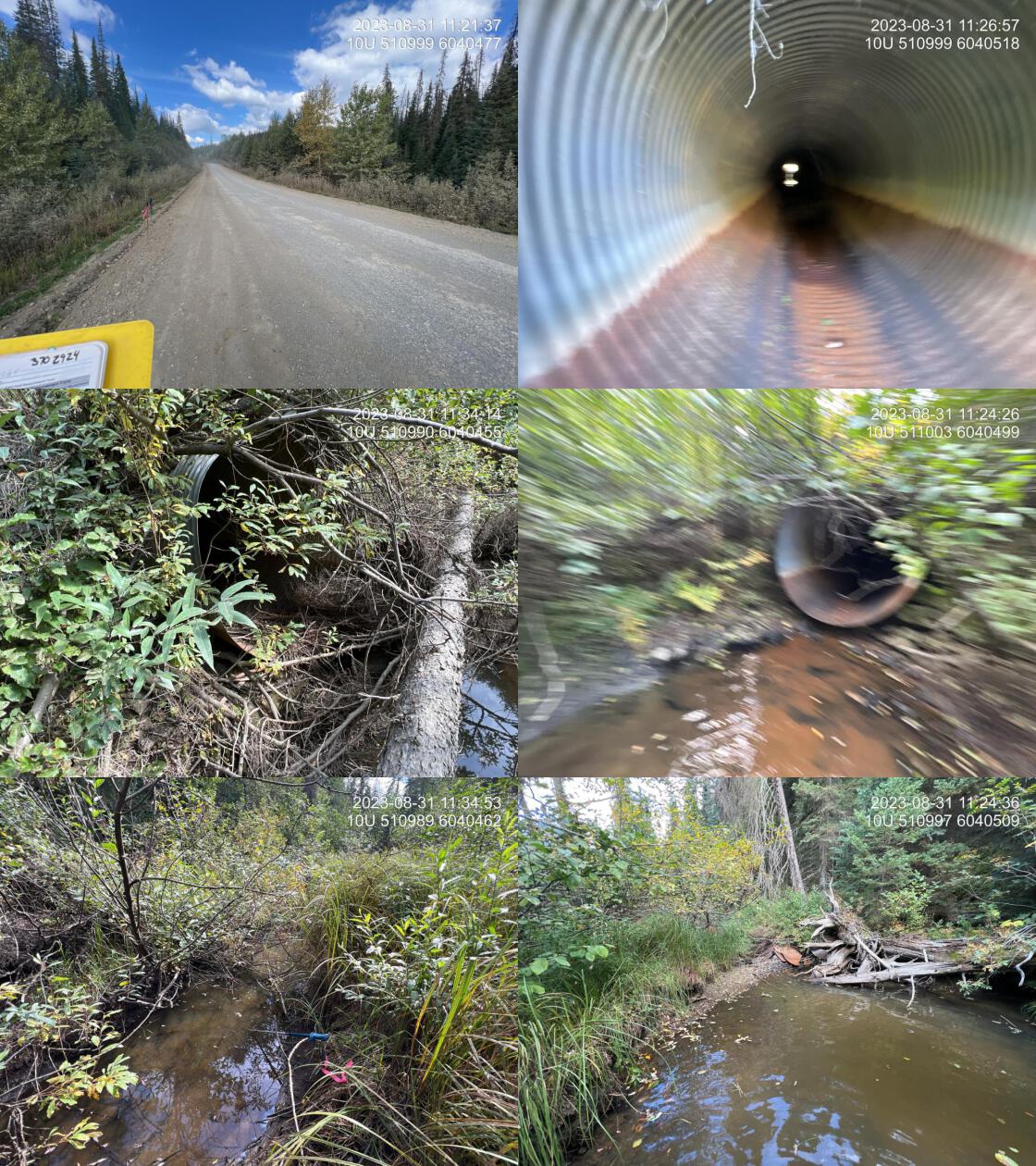 . From top left clockwise: Road/Site Card, Barrel, Outlet, Downstream, Upstream, Inlet.3702924 . From top left clockwise: Road/Site Card, Barrel, Outlet, Downstream, Upstream, Inlet.3702924
|
|||
| Comments: Low gradient wetland type habitat with fine substrates upstream. Decent size drainage with some water in the channel but no actual flow. Some gravels downstream. Pipe is separating approximately 5 m downstream from the inlet. 11:20:00 |
| Location and Stream Data |
|
Crossing Characteristics | – |
|---|---|---|---|
| Date | 2023-08-31 | Crossing Sub Type | Round Culvert |
| PSCIS ID | 198714 | Diameter (m) | 1.2 |
| External ID | 2023083101 | Length (m) | 8 |
| Crew | AI MD | Embedded | No |
| UTM Zone | 10 | Depth Embedded (m) | – |
| Easting | 497758.4 | Resemble Channel | No |
| Northing | 6093674 | Backwatered | No |
| Stream | Tributary to McLeod Lake | Percent Backwatered | – |
| Road | Campground Rd | Fill Depth (m) | 0.5 |
| Road Tenure | MOE | Outlet Drop (m) | 0 |
| Channel Width (m) | 2.3 | Outlet Pool Depth (m) | 0.3 |
| Stream Slope (%) | 2 | Inlet Drop | Yes |
| Beaver Activity | Yes | Slope (%) | 5 |
| Habitat Value | Medium | Valley Fill | Deep Fill |
| Final score | 26 | Barrier Result | Barrier |
| Fix type | Replace with New Open Bottom Structure | Fix Span / Diameter | 10 |
Photos: PSCIS ID 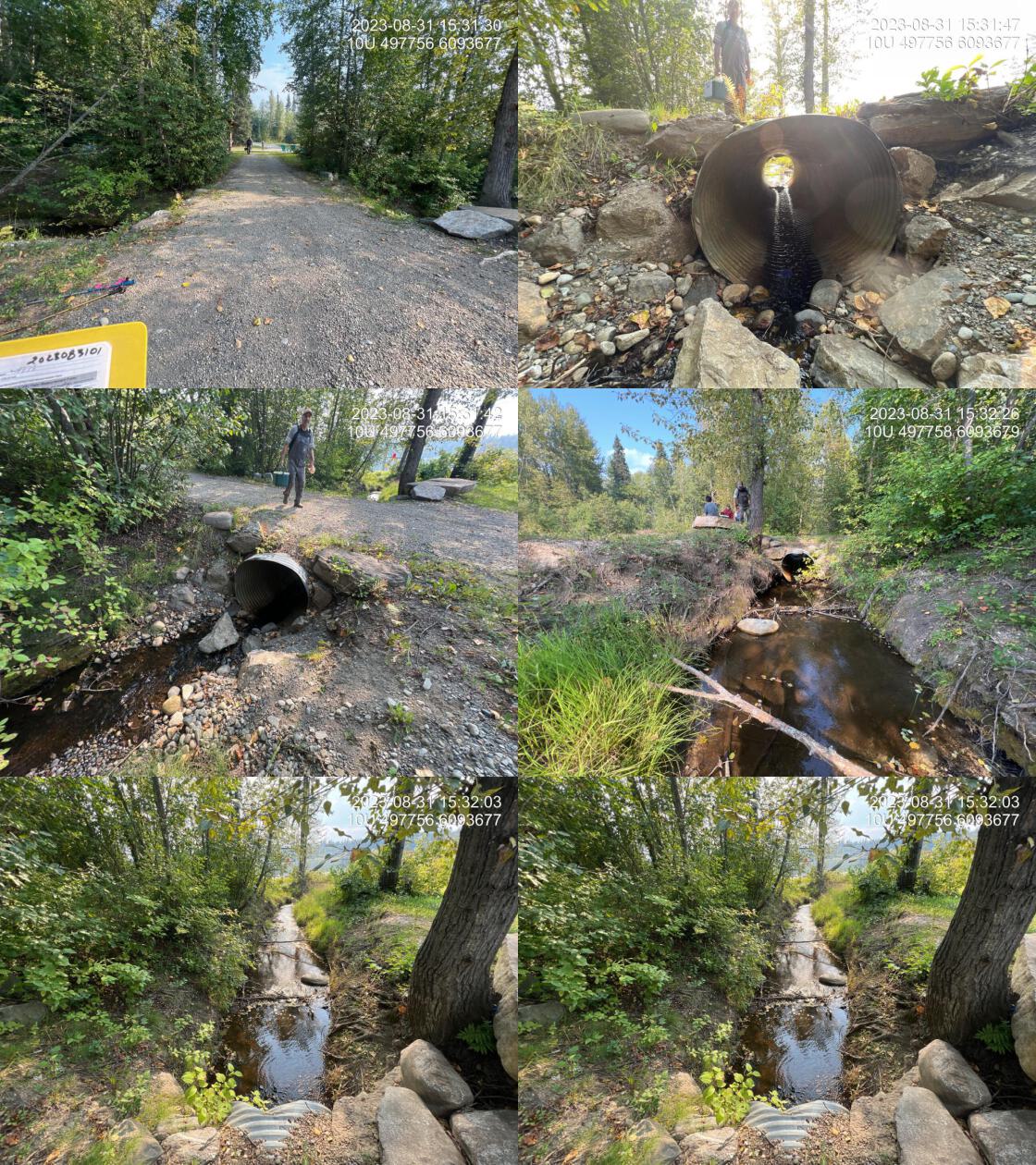 . From top left clockwise: Road/Site Card, Barrel, Outlet, Downstream, Upstream, Inlet.2023083101 . From top left clockwise: Road/Site Card, Barrel, Outlet, Downstream, Upstream, Inlet.2023083101
|
|||
| Comments: Small culvert within the campground area. Approximately 40 m upstream of the mouth of the lake. 15:29:22 |
| Location and Stream Data |
|
Crossing Characteristics | – |
|---|---|---|---|
| Date | 2023-09-01 | Crossing Sub Type | Bridge |
| PSCIS ID | 198715 | Diameter (m) | 7 |
| External ID | 3701326 | Length (m) | 4 |
| Crew | MW | Embedded | – |
| UTM Zone | 10 | Depth Embedded (m) | – |
| Easting | 512973.3 | Resemble Channel | – |
| Northing | 6072307 | Backwatered | – |
| Stream | Tributary to 42 Mile Creek | Percent Backwatered | – |
| Road | Unnamed | Fill Depth (m) | – |
| Road Tenure | B.C. Custom Timber Products Ltd. | Outlet Drop (m) | – |
| Channel Width (m) | – | Outlet Pool Depth (m) | – |
| Stream Slope (%) | – | Inlet Drop | – |
| Beaver Activity | No | Slope (%) | – |
| Habitat Value | – | Valley Fill | – |
| Final score | 0 | Barrier Result | Passable |
| Fix type | – | Fix Span / Diameter | – |
Photos: PSCIS ID 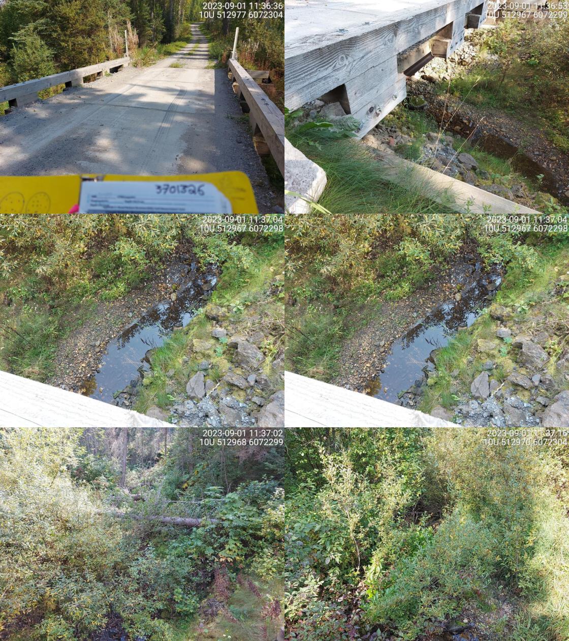 . From top left clockwise: Road/Site Card, Barrel, Outlet, Downstream, Upstream, Inlet.3701326 . From top left clockwise: Road/Site Card, Barrel, Outlet, Downstream, Upstream, Inlet.3701326
|
|||
| Comments: Small stream with some flow. 11:37:53 |
| Location and Stream Data |
|
Crossing Characteristics | – |
|---|---|---|---|
| Date | 2023-09-01 | Crossing Sub Type | Round Culvert |
| PSCIS ID | 198716 | Diameter (m) | 0.5 |
| External ID | 3700333 | Length (m) | 7 |
| Crew | MW | Embedded | No |
| UTM Zone | 10 | Depth Embedded (m) | – |
| Easting | 512837.1 | Resemble Channel | No |
| Northing | 6072245 | Backwatered | No |
| Stream | 42 Mile Creek | Percent Backwatered | – |
| Road | Unnamed | Fill Depth (m) | 1.5 |
| Road Tenure | B.C. Custom Timber Products Ltd. | Outlet Drop (m) | 0 |
| Channel Width (m) | 1.6 | Outlet Pool Depth (m) | 0 |
| Stream Slope (%) | 2.5 | Inlet Drop | No |
| Beaver Activity | No | Slope (%) | 2 |
| Habitat Value | Low | Valley Fill | Deep Fill |
| Final score | 21 | Barrier Result | Barrier |
| Fix type | Replace Structure with Streambed Simulation CBS | Fix Span / Diameter | 3 |
Photos: PSCIS ID 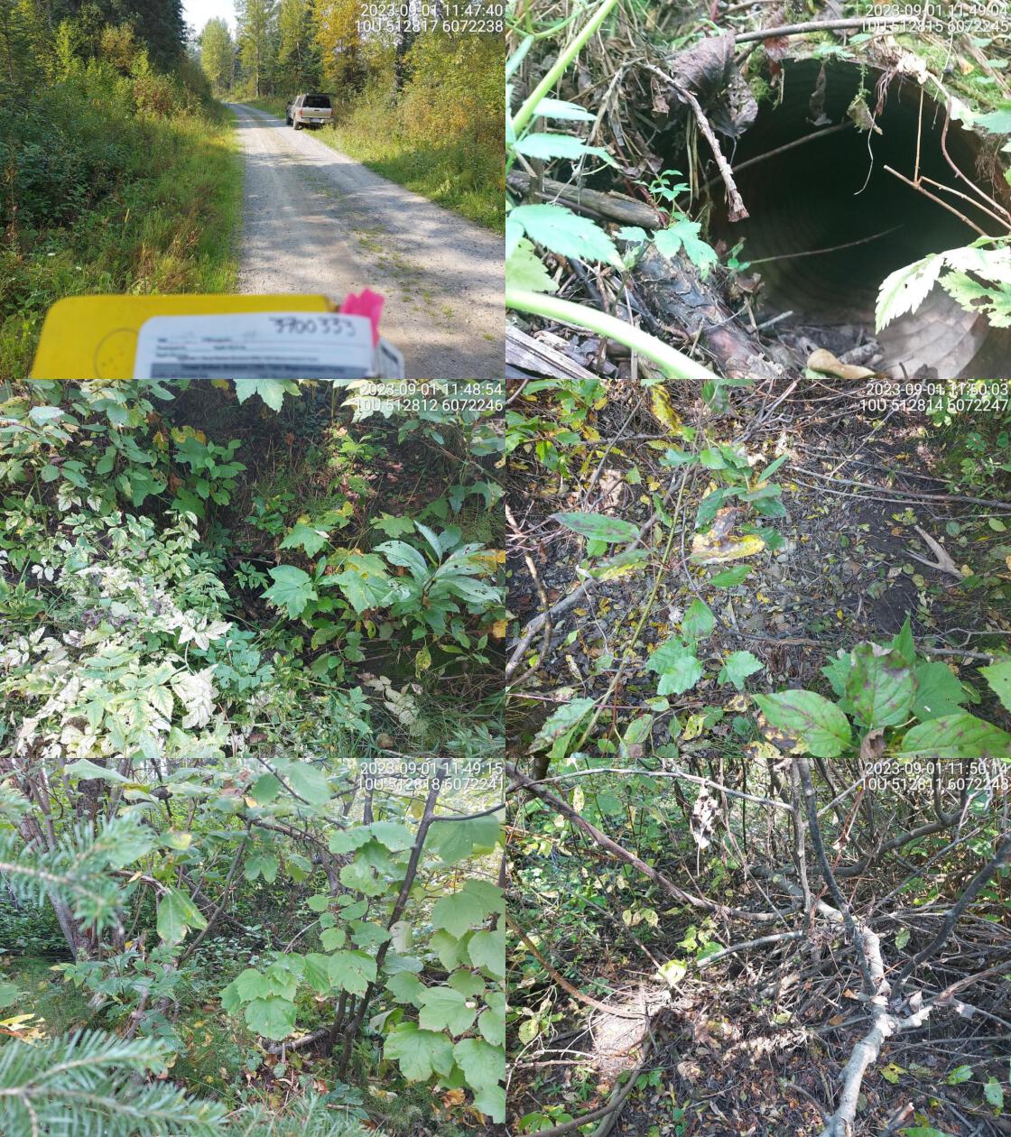 . From top left clockwise: Road/Site Card, Barrel, Outlet, Downstream, Upstream, Inlet.3700333 . From top left clockwise: Road/Site Card, Barrel, Outlet, Downstream, Upstream, Inlet.3700333
|
|||
| Comments: Very small culvert, dewatered. No well defined channel present. Channel width and slope estimated. Main flow of stream likely goes under bridge nearby. 11:52:39 |
| Location and Stream Data |
|
Crossing Characteristics | – |
|---|---|---|---|
| Date | 2023-09-01 | Crossing Sub Type | Round Culvert |
| PSCIS ID | 198717 | Diameter (m) | 1.2 |
| External ID | 3700192 | Length (m) | 15 |
| Crew | MW | Embedded | No |
| UTM Zone | 10 | Depth Embedded (m) | – |
| Easting | 520582.7 | Resemble Channel | No |
| Northing | 6037949 | Backwatered | No |
| Stream | Tributary to Crooked River | Percent Backwatered | – |
| Road | Spur | Fill Depth (m) | 3.5 |
| Road Tenure | Unclassified | Outlet Drop (m) | 0 |
| Channel Width (m) | 1.2 | Outlet Pool Depth (m) | 0 |
| Stream Slope (%) | 1.5 | Inlet Drop | No |
| Beaver Activity | Yes | Slope (%) | 1 |
| Habitat Value | Low | Valley Fill | Deep Fill |
| Final score | 21 | Barrier Result | Barrier |
| Fix type | Replace Structure with Streambed Simulation CBS | Fix Span / Diameter | 3 |
Photos: PSCIS ID 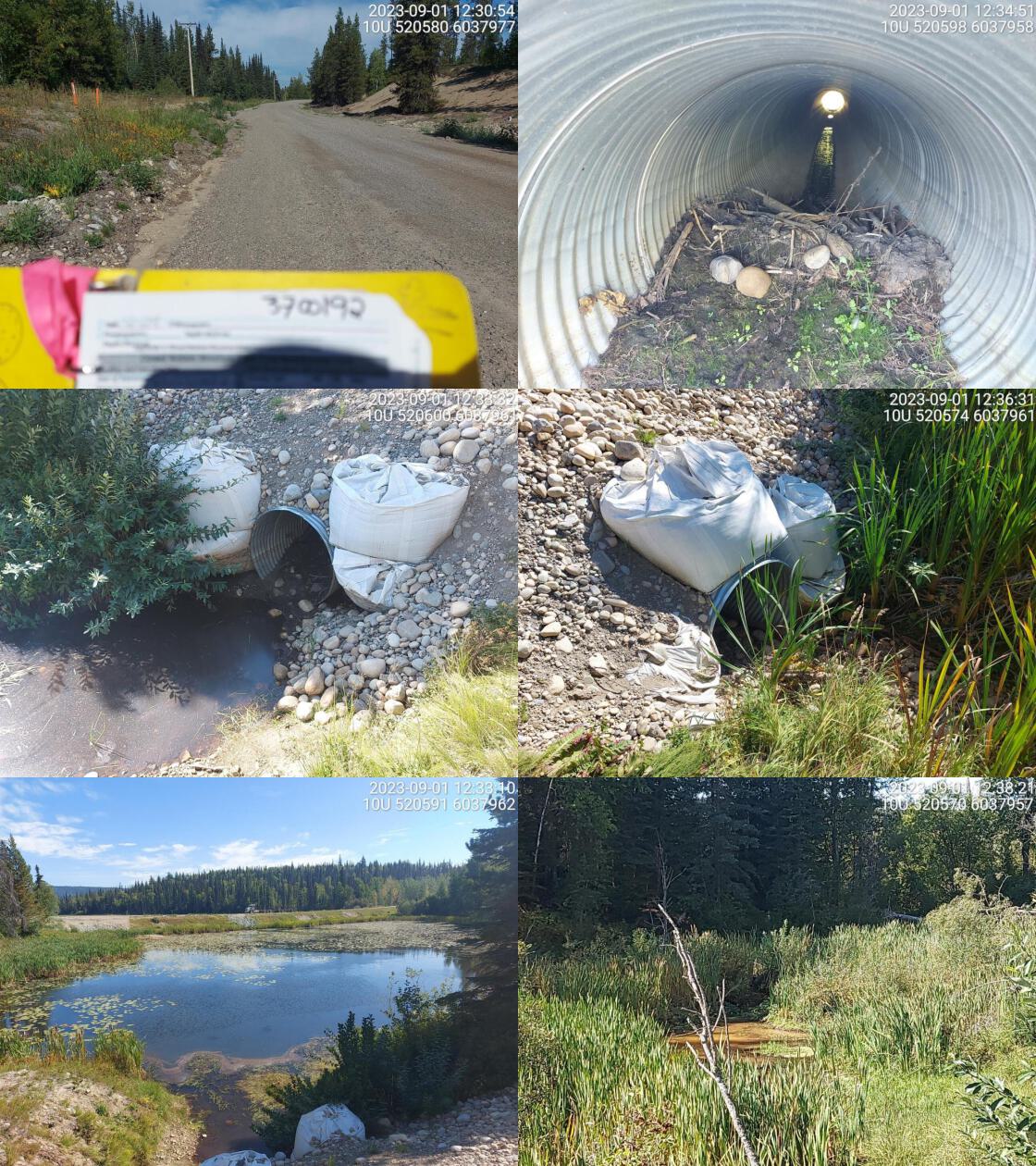 . From top left clockwise: Road/Site Card, Barrel, Outlet, Downstream, Upstream, Inlet.3700192 . From top left clockwise: Road/Site Card, Barrel, Outlet, Downstream, Upstream, Inlet.3700192
|
|||
| Comments: Wetland upstream and downstream. Stream gradient estimated. No water in culvert, dewatered downstream near crossing. Blockage at inlet from beaver mud dam. Steep embankment above culvert, risk of rockslide high. Big sacks on inlet and outlet holding embankment in place. Lake chub and brassy minnow confirmed in the past near highway. 12:31:41 |
| Location and Stream Data |
|
Crossing Characteristics | – |
|---|---|---|---|
| Date | 2023-09-01 | Crossing Sub Type | Bridge |
| PSCIS ID | 198718 | Diameter (m) | 13 |
| External ID | 3702076 | Length (m) | 5 |
| Crew | MW | Embedded | – |
| UTM Zone | 10 | Depth Embedded (m) | – |
| Easting | 521415.2 | Resemble Channel | – |
| Northing | 6018921 | Backwatered | – |
| Stream | Teapot Creek | Percent Backwatered | – |
| Road | Caine Creek FSR | Fill Depth (m) | – |
| Road Tenure | Canfor R02852 | Outlet Drop (m) | – |
| Channel Width (m) | – | Outlet Pool Depth (m) | – |
| Stream Slope (%) | – | Inlet Drop | – |
| Beaver Activity | No | Slope (%) | – |
| Habitat Value | – | Valley Fill | – |
| Final score | 0 | Barrier Result | Passable |
| Fix type | – | Fix Span / Diameter | – |
Photos: PSCIS ID 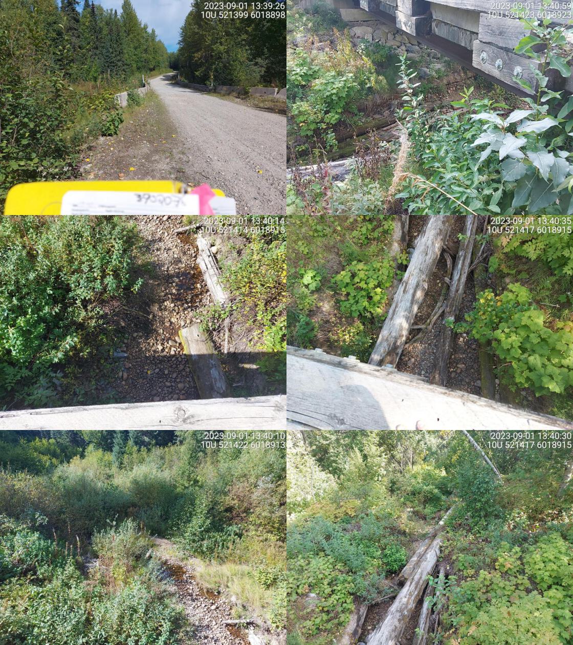 . From top left clockwise: Road/Site Card, Barrel, Outlet, Downstream, Upstream, Inlet.3702076 . From top left clockwise: Road/Site Card, Barrel, Outlet, Downstream, Upstream, Inlet.3702076
|
|||
| Comments: Very little flow and water at time of survey. Huge downed trees on downstream side. 13:41:31 |
| Location and Stream Data |
|
Crossing Characteristics | – |
|---|---|---|---|
| Date | 2023-09-01 | Crossing Sub Type | Round Culvert |
| PSCIS ID | 198719 | Diameter (m) | 0.6 |
| External ID | 3702074 | Length (m) | 13 |
| Crew | MW | Embedded | No |
| UTM Zone | 10 | Depth Embedded (m) | – |
| Easting | 518848 | Resemble Channel | No |
| Northing | 6017917 | Backwatered | Yes |
| Stream | Balsam Creek | Percent Backwatered | 100 |
| Road | Caine Creek FSR | Fill Depth (m) | 1 |
| Road Tenure | MOF 7694 | Outlet Drop (m) | 0 |
| Channel Width (m) | 1.2 | Outlet Pool Depth (m) | 0.7 |
| Stream Slope (%) | 1.5 | Inlet Drop | No |
| Beaver Activity | No | Slope (%) | 4 |
| Habitat Value | Low | Valley Fill | Deep Fill |
| Final score | 26 | Barrier Result | Barrier |
| Fix type | Replace Structure with Streambed Simulation CBS | Fix Span / Diameter | 3 |
Photos: PSCIS ID 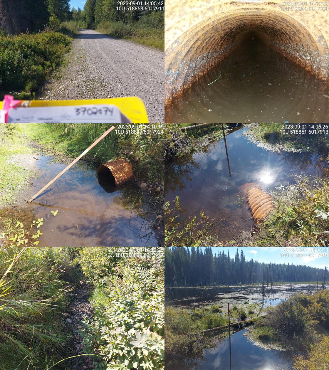 . From top left clockwise: Road/Site Card, Barrel, Outlet, Downstream, Upstream, Inlet.3702074 . From top left clockwise: Road/Site Card, Barrel, Outlet, Downstream, Upstream, Inlet.3702074
|
|||
| Comments: Culvert was in wrong location on map. It is actually located on road approximately 95m east of modelled crossing location. A lot of fry fish spotted near outlet. Culvert very rusted and near the end of its life. Small channel upstream running along road for 20m but no defined channel after that. 14:02:57 |
| Location and Stream Data |
|
Crossing Characteristics | – |
|---|---|---|---|
| Date | 2023-09-01 | Crossing Sub Type | Round Culvert |
| PSCIS ID | 198720 | Diameter (m) | 0.7 |
| External ID | 3702077 | Length (m) | 12 |
| Crew | MW | Embedded | No |
| UTM Zone | 10 | Depth Embedded (m) | – |
| Easting | 517337.7 | Resemble Channel | No |
| Northing | 6018000 | Backwatered | Yes |
| Stream | Enquist Creek | Percent Backwatered | 100 |
| Road | Caine Creek FSR | Fill Depth (m) | 1.5 |
| Road Tenure | MOF 7694 | Outlet Drop (m) | 0 |
| Channel Width (m) | 1.9 | Outlet Pool Depth (m) | 0.4 |
| Stream Slope (%) | 3 | Inlet Drop | No |
| Beaver Activity | Yes | Slope (%) | 0.5 |
| Habitat Value | Medium | Valley Fill | Deep Fill |
| Final score | 16 | Barrier Result | Potential |
| Fix type | Replace Structure with Streambed Simulation CBS | Fix Span / Diameter | 3 |
Photos: PSCIS ID 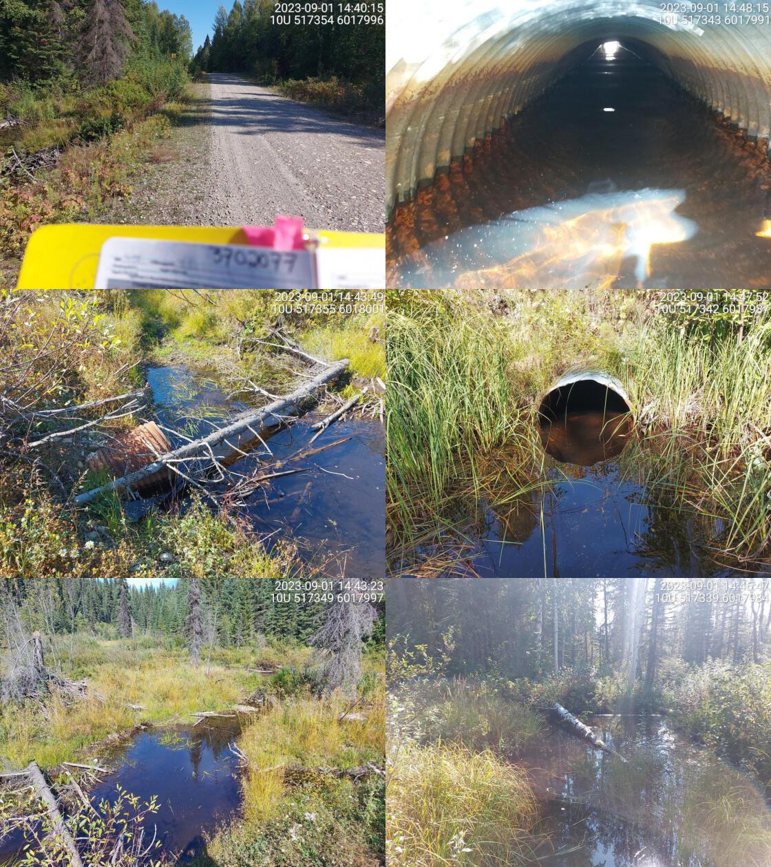 . From top left clockwise: Road/Site Card, Barrel, Outlet, Downstream, Upstream, Inlet.3702077 . From top left clockwise: Road/Site Card, Barrel, Outlet, Downstream, Upstream, Inlet.3702077
|
|||
| Comments: Fry and parr spotted upstream and downstream of crossing. Culvert very rusted on inlet side. Wetland habitat upstream. Channel narrows downstream and is a little overgrown but has moderate flow. Enquist Lake located upstream. 14:41:51 |
| Location and Stream Data |
|
Crossing Characteristics | – |
|---|---|---|---|
| Date | 2023-09-01 | Crossing Sub Type | Round Culvert |
| PSCIS ID | 198721 | Diameter (m) | 0.6 |
| External ID | 3702073 | Length (m) | 13 |
| Crew | MW | Embedded | No |
| UTM Zone | 10 | Depth Embedded (m) | – |
| Easting | 516959.5 | Resemble Channel | No |
| Northing | 6018229 | Backwatered | No |
| Stream | Tributary to Summit Lake | Percent Backwatered | – |
| Road | Caine Creek FSR | Fill Depth (m) | 0.5 |
| Road Tenure | MOF 7694 | Outlet Drop (m) | 0 |
| Channel Width (m) | 1.7 | Outlet Pool Depth (m) | 0 |
| Stream Slope (%) | 1.5 | Inlet Drop | No |
| Beaver Activity | No | Slope (%) | 2 |
| Habitat Value | Low | Valley Fill | Deep Fill |
| Final score | 21 | Barrier Result | Barrier |
| Fix type | Replace Structure with Streambed Simulation CBS | Fix Span / Diameter | 3 |
Photos: PSCIS ID 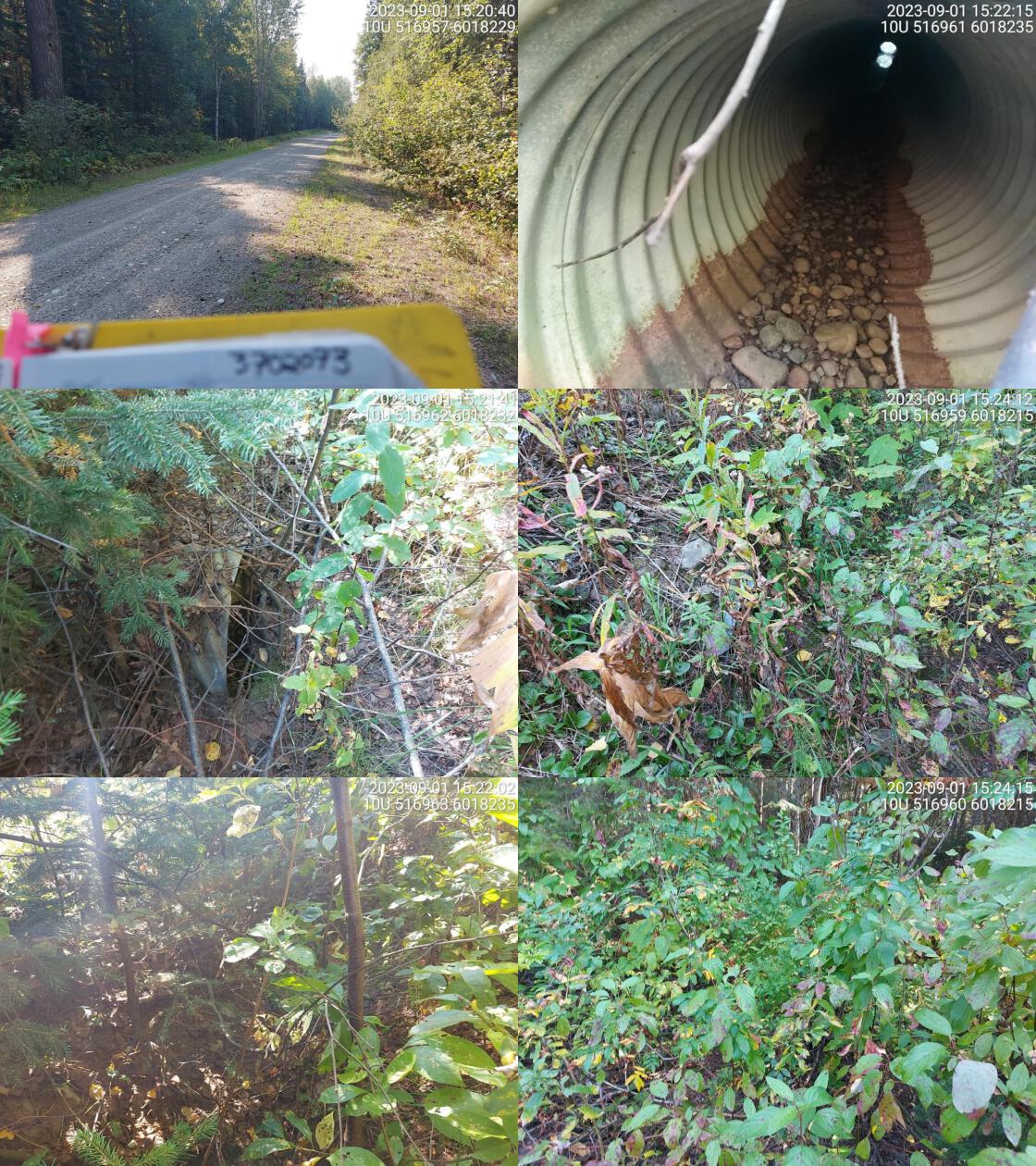 . From top left clockwise: Road/Site Card, Barrel, Outlet, Downstream, Upstream, Inlet.3702073 . From top left clockwise: Road/Site Card, Barrel, Outlet, Downstream, Upstream, Inlet.3702073
|
|||
| Comments: Stream is dewatered. No clearly defined channel up or downstream. Small tree growing on inlet side, sign that there hasn’t been water flowing in a long time. Channel width and slope estimated. 15:19:23 |
| Location and Stream Data |
|
Crossing Characteristics | – |
|---|---|---|---|
| Date | 2023-09-01 | Crossing Sub Type | Bridge |
| PSCIS ID | 198722 | Diameter (m) | 12 |
| External ID | 3700931 | Length (m) | 2 |
| Crew | MW | Embedded | – |
| UTM Zone | 10 | Depth Embedded (m) | – |
| Easting | 519546.9 | Resemble Channel | – |
| Northing | 6017742 | Backwatered | – |
| Stream | Balsam Creek | Percent Backwatered | – |
| Road | Spur | Fill Depth (m) | – |
| Road Tenure | Unclassified | Outlet Drop (m) | – |
| Channel Width (m) | – | Outlet Pool Depth (m) | – |
| Stream Slope (%) | – | Inlet Drop | – |
| Beaver Activity | No | Slope (%) | – |
| Habitat Value | – | Valley Fill | – |
| Final score | 0 | Barrier Result | Passable |
| Fix type | – | Fix Span / Diameter | – |
Photos: PSCIS ID 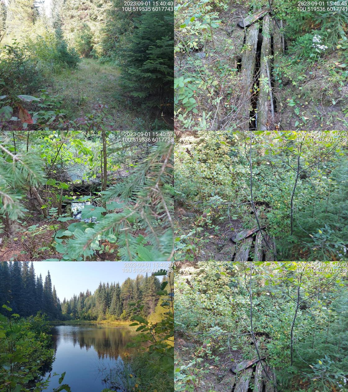 . From top left clockwise: Road/Site Card, Barrel, Outlet, Downstream, Upstream, Inlet.3700931 . From top left clockwise: Road/Site Card, Barrel, Outlet, Downstream, Upstream, Inlet.3700931
|
|||
| Comments: Looks like there was once a very old bridge here. Very overgrown and rotten. Water passing underneath but not flowing. Not a fish passage issue. 15:38:42 |
| Location and Stream Data |
|
Crossing Characteristics | – |
|---|---|---|---|
| Date | 2023-09-02 | Crossing Sub Type | Round Culvert |
| PSCIS ID | 198723 | Diameter (m) | 1.4 |
| External ID | 3701268 | Length (m) | 5 |
| Crew | MW | Embedded | No |
| UTM Zone | 10 | Depth Embedded (m) | – |
| Easting | 513674 | Resemble Channel | No |
| Northing | 6067268 | Backwatered | Yes |
| Stream | Tributary to Altezega Creek | Percent Backwatered | 75 |
| Road | Spur | Fill Depth (m) | 0.5 |
| Road Tenure | Unclassified | Outlet Drop (m) | 0 |
| Channel Width (m) | 2.2 | Outlet Pool Depth (m) | 0.4 |
| Stream Slope (%) | 1 | Inlet Drop | No |
| Beaver Activity | No | Slope (%) | 1 |
| Habitat Value | High | Valley Fill | Deep Fill |
| Final score | 21 | Barrier Result | Barrier |
| Fix type | Replace with New Open Bottom Structure | Fix Span / Diameter | 14 |
Photos: PSCIS ID 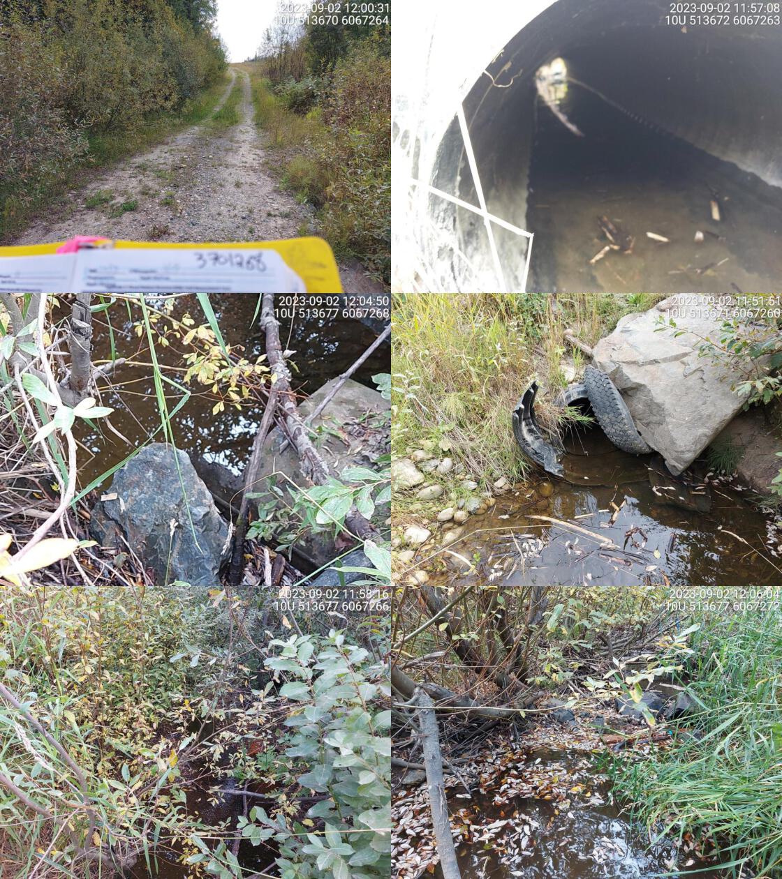 . From top left clockwise: Road/Site Card, Barrel, Outlet, Downstream, Upstream, Inlet.3701268 . From top left clockwise: Road/Site Card, Barrel, Outlet, Downstream, Upstream, Inlet.3701268
|
|||
| Comments: Two culverts, one plastic pipe and one really old metal pipe. Metal pipe is longer, outlets are at different spots. 11:58:55 |
| Location and Stream Data |
|
Crossing Characteristics | – |
|---|---|---|---|
| Date | 2023-09-02 | Crossing Sub Type | Bridge |
| PSCIS ID | 198724 | Diameter (m) | 8 |
| External ID | 3702414 | Length (m) | 4 |
| Crew | MW | Embedded | – |
| UTM Zone | 10 | Depth Embedded (m) | – |
| Easting | 517706.7 | Resemble Channel | – |
| Northing | 6068217 | Backwatered | – |
| Stream | Tributary to Altezega Creek | Percent Backwatered | – |
| Road | Firth Lake FSR | Fill Depth (m) | – |
| Road Tenure | MOF 8385 | Outlet Drop (m) | – |
| Channel Width (m) | – | Outlet Pool Depth (m) | – |
| Stream Slope (%) | – | Inlet Drop | – |
| Beaver Activity | No | Slope (%) | – |
| Habitat Value | – | Valley Fill | – |
| Final score | 0 | Barrier Result | Passable |
| Fix type | – | Fix Span / Diameter | – |
Photos: PSCIS ID 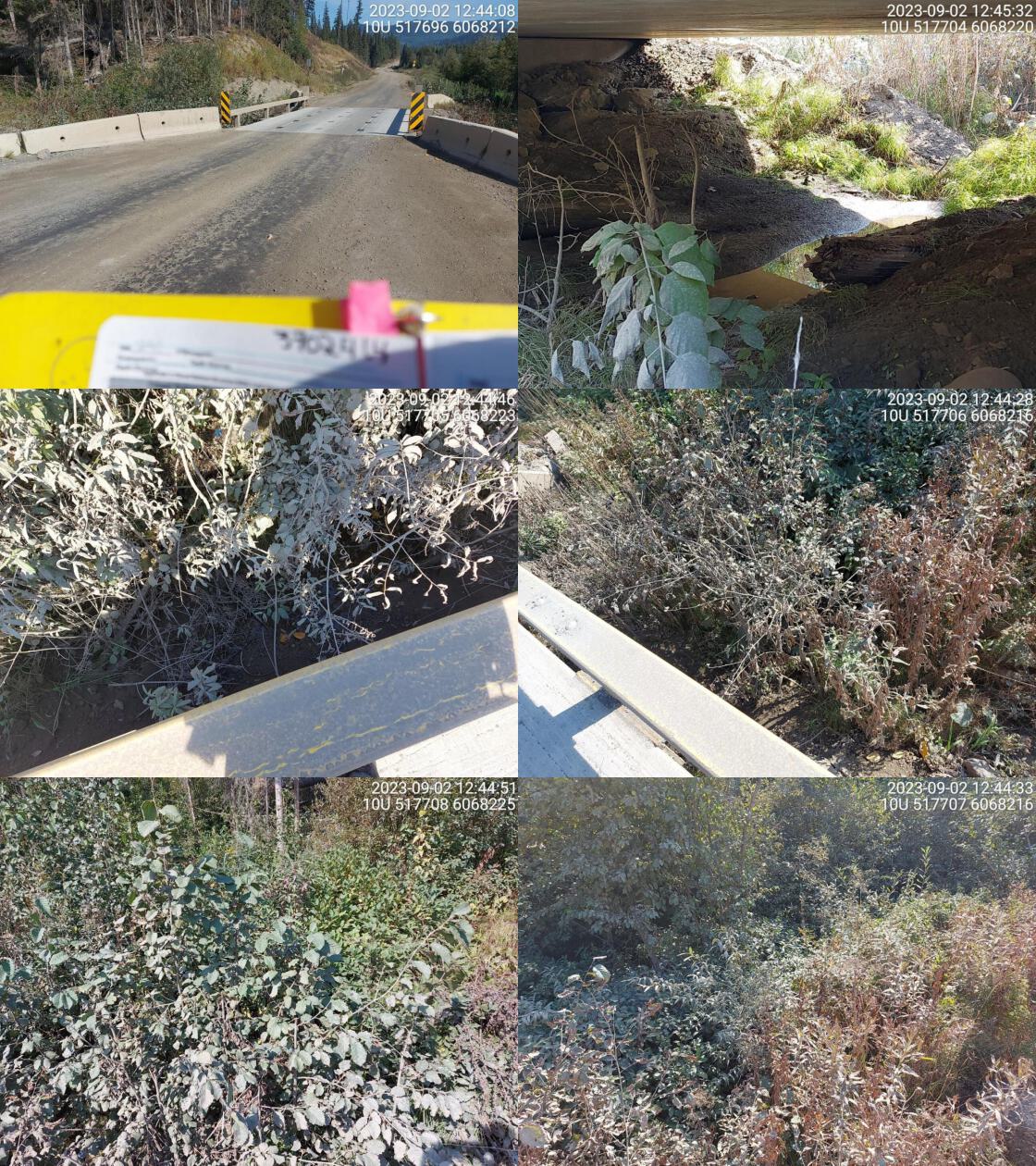 . From top left clockwise: Road/Site Card, Barrel, Outlet, Downstream, Upstream, Inlet.3702414 . From top left clockwise: Road/Site Card, Barrel, Outlet, Downstream, Upstream, Inlet.3702414
|
|||
| Comments: No water flowing under bridge at time of survey. Dewatered downstream. 12:46:41 |
| Location and Stream Data |
|
Crossing Characteristics | – |
|---|---|---|---|
| Date | 2023-09-02 | Crossing Sub Type | Bridge |
| PSCIS ID | 198725 | Diameter (m) | 16 |
| External ID | 3702410 | Length (m) | 4 |
| Crew | MW | Embedded | – |
| UTM Zone | 10 | Depth Embedded (m) | – |
| Easting | 517910.6 | Resemble Channel | – |
| Northing | 6068378 | Backwatered | – |
| Stream | Altezega Creek | Percent Backwatered | – |
| Road | Firth Lake FSR | Fill Depth (m) | – |
| Road Tenure | MOF 8385 | Outlet Drop (m) | – |
| Channel Width (m) | – | Outlet Pool Depth (m) | – |
| Stream Slope (%) | – | Inlet Drop | – |
| Beaver Activity | No | Slope (%) | – |
| Habitat Value | – | Valley Fill | – |
| Final score | 0 | Barrier Result | Passable |
| Fix type | – | Fix Span / Diameter | – |
Photos: PSCIS ID 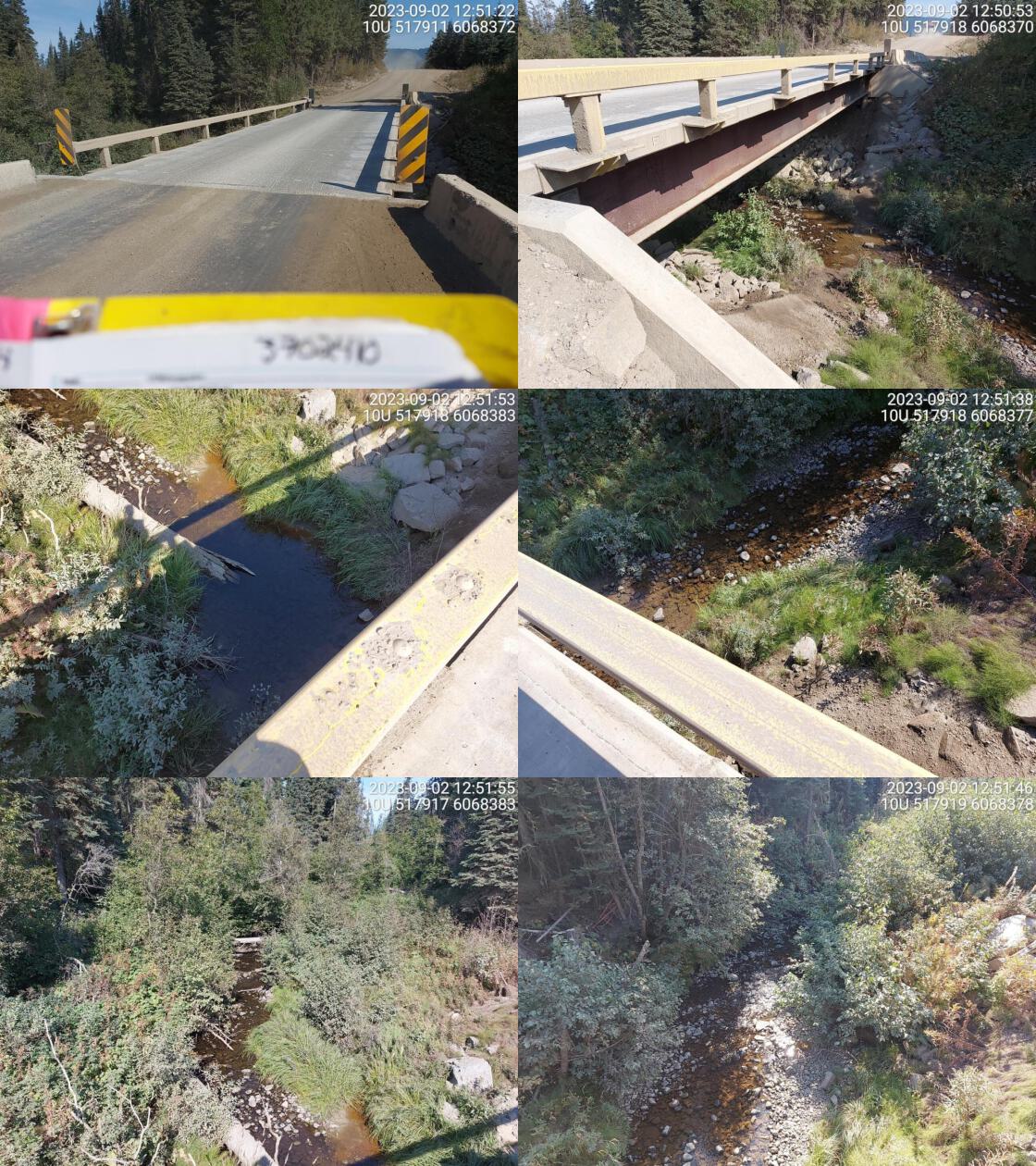 . From top left clockwise: Road/Site Card, Barrel, Outlet, Downstream, Upstream, Inlet.3702410 . From top left clockwise: Road/Site Card, Barrel, Outlet, Downstream, Upstream, Inlet.3702410
|
|||
| Comments: Nice looking stream with good flow. 12:52:35 |
| Location and Stream Data |
|
Crossing Characteristics | – |
|---|---|---|---|
| Date | 2023-09-02 | Crossing Sub Type | Bridge |
| PSCIS ID | 198726 | Diameter (m) | 10 |
| External ID | 3702416 | Length (m) | 4 |
| Crew | MW | Embedded | – |
| UTM Zone | 10 | Depth Embedded (m) | – |
| Easting | 518807.9 | Resemble Channel | – |
| Northing | 6067912 | Backwatered | – |
| Stream | Tributary to Altezega Creek | Percent Backwatered | – |
| Road | Firth Lake FSR | Fill Depth (m) | – |
| Road Tenure | MOF 8385 | Outlet Drop (m) | – |
| Channel Width (m) | – | Outlet Pool Depth (m) | – |
| Stream Slope (%) | – | Inlet Drop | – |
| Beaver Activity | No | Slope (%) | – |
| Habitat Value | – | Valley Fill | – |
| Final score | 0 | Barrier Result | Passable |
| Fix type | – | Fix Span / Diameter | – |
Photos: PSCIS ID 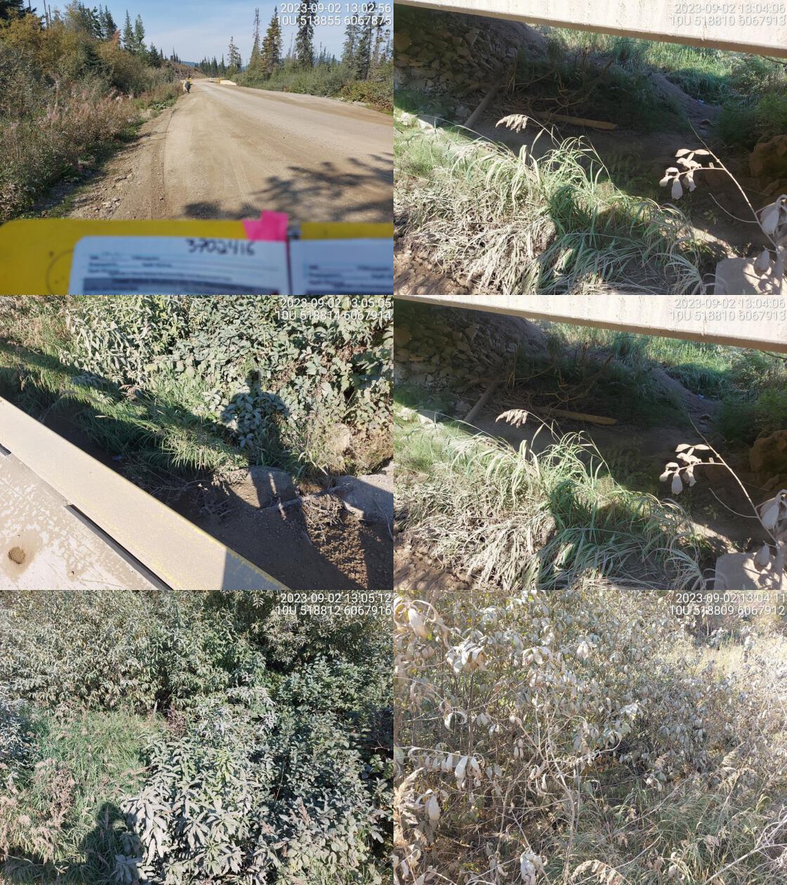 . From top left clockwise: Road/Site Card, Barrel, Outlet, Downstream, Upstream, Inlet.3702416 . From top left clockwise: Road/Site Card, Barrel, Outlet, Downstream, Upstream, Inlet.3702416
|
|||
| Comments: Dewatered stream at time of survey. 13:05:36 |
| Location and Stream Data |
|
Crossing Characteristics | – |
|---|---|---|---|
| Date | 2023-09-02 | Crossing Sub Type | Bridge |
| PSCIS ID | 198727 | Diameter (m) | 17 |
| External ID | 3701315 | Length (m) | 4 |
| Crew | MW | Embedded | – |
| UTM Zone | 10 | Depth Embedded (m) | – |
| Easting | 520855.7 | Resemble Channel | – |
| Northing | 6068064 | Backwatered | – |
| Stream | Tributary to Altezega Creek | Percent Backwatered | – |
| Road | Firth Lake FSR | Fill Depth (m) | – |
| Road Tenure | Canfor R01860 | Outlet Drop (m) | – |
| Channel Width (m) | – | Outlet Pool Depth (m) | – |
| Stream Slope (%) | – | Inlet Drop | – |
| Beaver Activity | No | Slope (%) | – |
| Habitat Value | – | Valley Fill | – |
| Final score | 0 | Barrier Result | Passable |
| Fix type | – | Fix Span / Diameter | – |
Photos: PSCIS ID 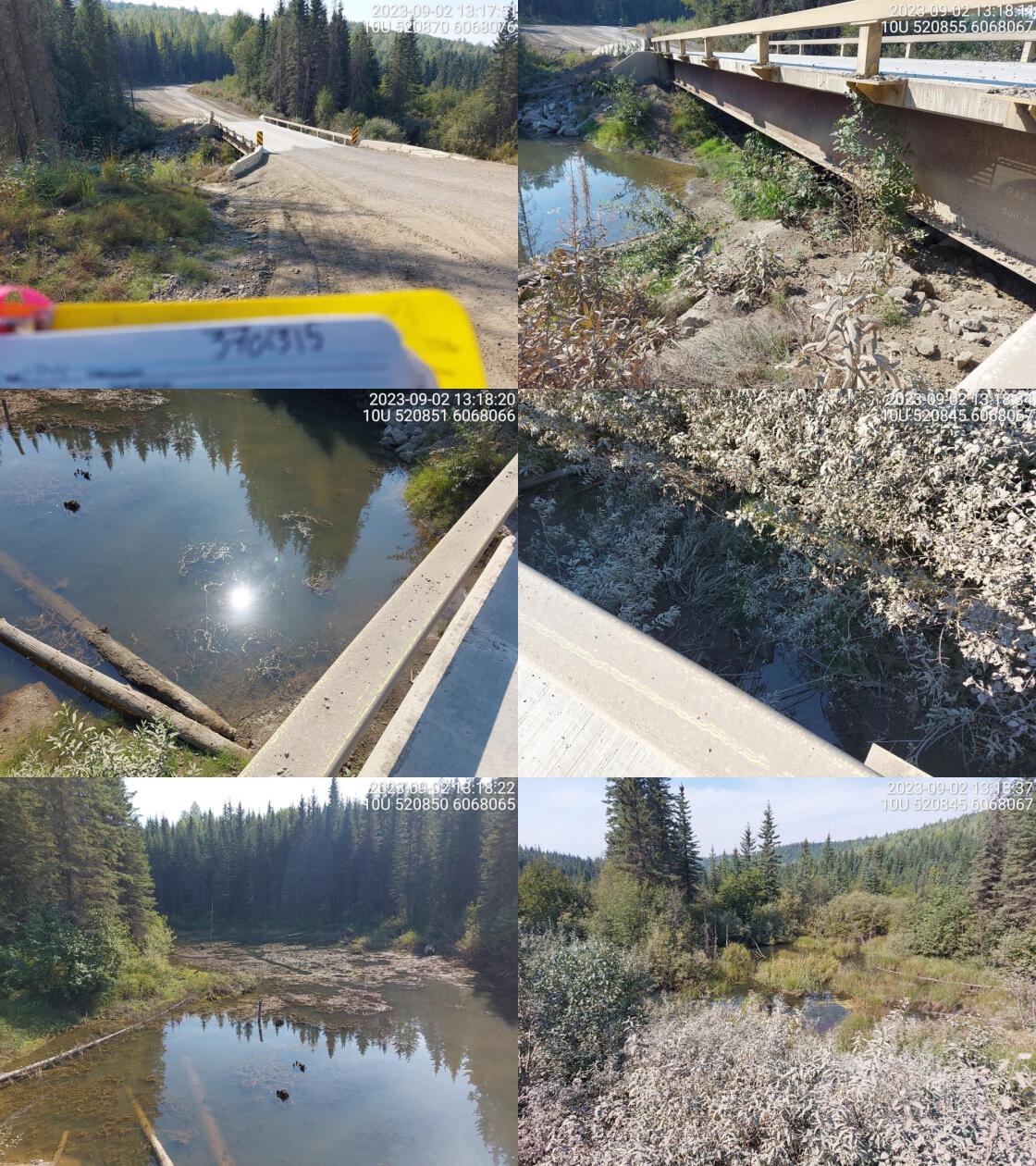 . From top left clockwise: Road/Site Card, Barrel, Outlet, Downstream, Upstream, Inlet.3701315 . From top left clockwise: Road/Site Card, Barrel, Outlet, Downstream, Upstream, Inlet.3701315
|
|||
| Comments: Wetland upstream and downstream. No flowing water under bridge. 13:15:29 |
| Location and Stream Data |
|
Crossing Characteristics | – |
|---|---|---|---|
| Date | 2023-09-02 | Crossing Sub Type | Bridge |
| PSCIS ID | 198728 | Diameter (m) | 16 |
| External ID | 3700214 | Length (m) | 4 |
| Crew | MW | Embedded | – |
| UTM Zone | 10 | Depth Embedded (m) | – |
| Easting | 525275.5 | Resemble Channel | – |
| Northing | 6068222 | Backwatered | – |
| Stream | Redrocky Creek | Percent Backwatered | – |
| Road | Firth Lake FSR | Fill Depth (m) | – |
| Road Tenure | Canfor R01860 | Outlet Drop (m) | – |
| Channel Width (m) | – | Outlet Pool Depth (m) | – |
| Stream Slope (%) | – | Inlet Drop | – |
| Beaver Activity | No | Slope (%) | – |
| Habitat Value | – | Valley Fill | – |
| Final score | 0 | Barrier Result | Passable |
| Fix type | – | Fix Span / Diameter | – |
Photos: PSCIS ID 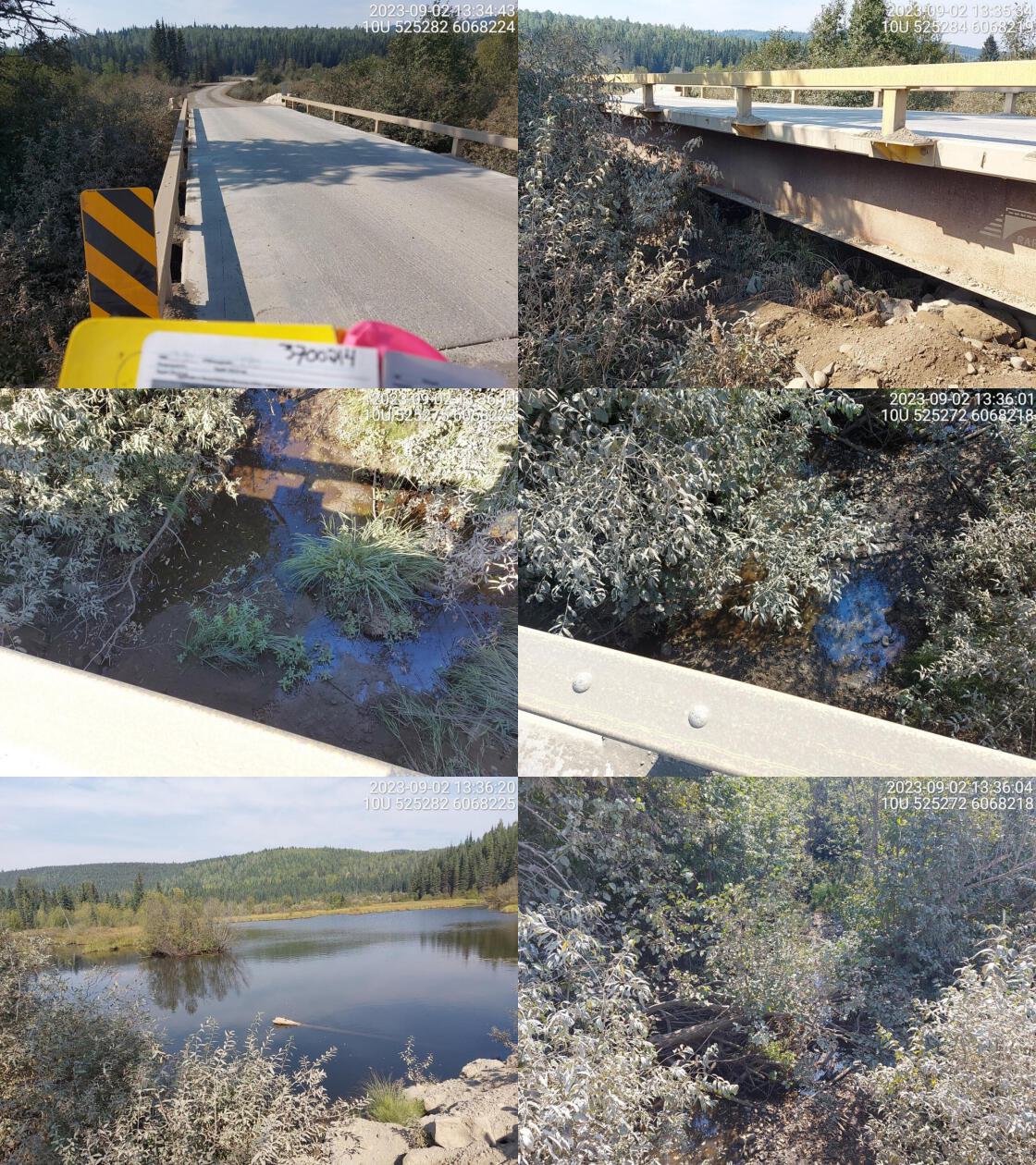 . From top left clockwise: Road/Site Card, Barrel, Outlet, Downstream, Upstream, Inlet.3700214 . From top left clockwise: Road/Site Card, Barrel, Outlet, Downstream, Upstream, Inlet.3700214
|
|||
| Comments: Small lake upstream. Modelled crossing was in wrong location. 13:32:39 |
| Location and Stream Data |
|
Crossing Characteristics | – |
|---|---|---|---|
| Date | 2023-09-02 | Crossing Sub Type | Bridge |
| PSCIS ID | 198729 | Diameter (m) | 10 |
| External ID | 3702575 | Length (m) | 4 |
| Crew | MW | Embedded | – |
| UTM Zone | 10 | Depth Embedded (m) | – |
| Easting | 522445.5 | Resemble Channel | – |
| Northing | 6053489 | Backwatered | – |
| Stream | Lincoln Creek | Percent Backwatered | – |
| Road | Chuchinka-Red Rocky FSR | Fill Depth (m) | – |
| Road Tenure | MOF 5506 | Outlet Drop (m) | – |
| Channel Width (m) | – | Outlet Pool Depth (m) | – |
| Stream Slope (%) | – | Inlet Drop | – |
| Beaver Activity | No | Slope (%) | – |
| Habitat Value | – | Valley Fill | – |
| Final score | 0 | Barrier Result | Passable |
| Fix type | – | Fix Span / Diameter | – |
Photos: PSCIS ID 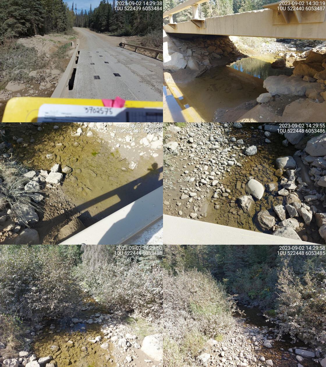 . From top left clockwise: Road/Site Card, Barrel, Outlet, Downstream, Upstream, Inlet.3702575 . From top left clockwise: Road/Site Card, Barrel, Outlet, Downstream, Upstream, Inlet.3702575
|
|||
| Comments: Nice stream with lots of water at time of survey. 14:30:26 |