Tributary to Altezega Creek - 198723 & 198694 - Appendix
Site Location
PSCIS crossings 198723 and 198694 are located on Tributary to Altezega Creek. Crossing 198723
is located on a small spur road and crossing 198694 is located on Firth Lake FSR.
The crossings are approximately 110m apart. The subject stream is just north of the Kerry Lake East 9 First Nation reserve.
The subject stream flows into Altezega Creek approximately 300m downstream of the lower crossing (PSCIS 198723). Altezega Creek in turn flows into the Crooked River approximately 600m downstream of this confluence. A culvert crossing is present on the mainstem of Altezega Creek where crossed by the Hart Highway (PSCIS crossing 198664 located 430m upstream from the Crooked River) and was also inventoried as part of the 2023 field assessments.
Background
Upstream of the crossings no fish have previously been recorded however, within Altezega Creek - longnose sucker, burbot, and rainbow trout have been recorded upstream of the highway crossing with burbot captured near the highway in 2008 (Norris [2018] 2024; MoE 2024).
A summary of habitat modelling outputs for crossing (198694) are presented in Table 5.21. The potential gains for 198723 can be assumed to be an additional 110m. A map of the watershed is provided in map attachment 093J.119.
| Habitat | Potential | Remediation Gain | Remediation Gain (%) |
|---|---|---|---|
| BT Rearing (km) | 4.4 | 2.9 | 66 |
| BT Spawning (km) | 3.4 | 2.8 | 82 |
| BT Network (km) | 28.2 | 7.2 | 26 |
| BT Stream (km) | 26.9 | 6.9 | 26 |
| BT Lake Reservoir (ha) | 3.7 | 1.2 | 32 |
| BT Wetland (ha) | 2.5 | 0.9 | 36 |
| BT Slopeclass03 (km) | 2.4 | 0.4 | 17 |
| BT Slopeclass05 (km) | 8.5 | 4.6 | 54 |
| BT Slopeclass08 (km) | 7.6 | 1.2 | 16 |
| BT Slopeclass15 (km) | 7.5 | 0.6 | 8 |
| * Model data is preliminary and subject to adjustments. |
Stream Characteristics at Crossing
At the time of the survey, PSCIS crossing 198723 was un-embedded and 75% backwatered. Although ranked as a barrier to upstream fish passage according to the provincial protocol (MoE 2011) the crossing is considered likely passable to all species and life stages at most flows due to the backwatering and a lack of an outlet drop (Table 5.22).
At the time of the survey, PSCIS crossing 198694 was un-embedded and not backwatered. Although ranked as a barrier to upstream fish passage according to the provincial protocol (MoE 2011) the crossing is considered potentially passable to most species and life stages at moderate to low flows due a lack of an outlet drop (Table 5.15).
Water temperature was 10.2\(^\circ\)C, pH was 8.2 and conductivity was 391uS/cm.
| Location and Stream Data |
|
Crossing Characteristics | – |
|---|---|---|---|
| Date | 2023-09-02 | Crossing Sub Type | Round Culvert |
| PSCIS ID | 198723 | Diameter (m) | 1.4 |
| External ID | – | Length (m) | 5 |
| Crew | MW | Embedded | No |
| UTM Zone | 10 | Depth Embedded (m) | – |
| Easting | 513674 | Resemble Channel | No |
| Northing | 6067268 | Backwatered | Yes |
| Stream | Tributary to Altezega Creek | Percent Backwatered | 75 |
| Road | Spur | Fill Depth (m) | 0.5 |
| Road Tenure | Unclassified | Outlet Drop (m) | 0 |
| Channel Width (m) | 2.2 | Outlet Pool Depth (m) | 0.4 |
| Stream Slope (%) | 1 | Inlet Drop | No |
| Beaver Activity | No | Slope (%) | 1 |
| Habitat Value | High | Valley Fill | Deep Fill |
| Final score | 21 | Barrier Result | Barrier |
| Fix type | Replace with New Open Bottom Structure | Fix Span / Diameter | 14 |
Photos: From top left clockwise: Road/Site Card, Barrel, Outlet, Downstream, Upstream, Inlet.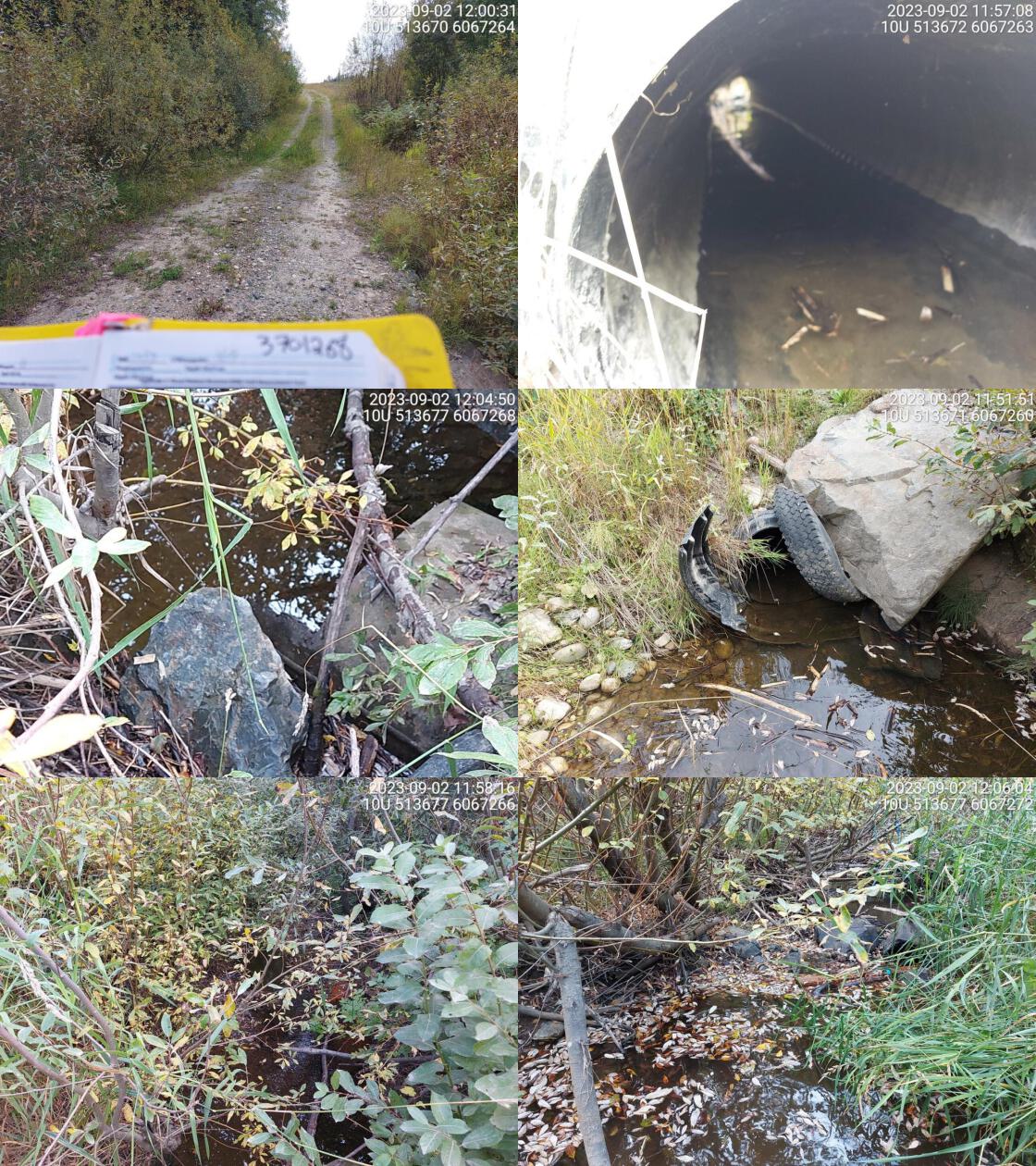
|
|||
| Comments: Two culverts, one plastic pipe and one really old metal pipe. Metal pipe is longer, outlets are at different spots. 11:58:55 |
| Location and Stream Data |
|
Crossing Characteristics | – |
|---|---|---|---|
| Date | 2023-08-29 | Crossing Sub Type | Round Culvert |
| PSCIS ID | 198694 | Diameter (m) | 0.75 |
| External ID | – | Length (m) | 12 |
| Crew | MW | Embedded | No |
| UTM Zone | 10 | Depth Embedded (m) | – |
| Easting | 513782.8 | Resemble Channel | No |
| Northing | 6067301 | Backwatered | No |
| Stream | Tributary to Altezega Creek | Percent Backwatered | – |
| Road | Firth Lake FSR | Fill Depth (m) | 1.5 |
| Road Tenure | MOF 8385 | Outlet Drop (m) | 0 |
| Channel Width (m) | 2.2 | Outlet Pool Depth (m) | 0.7 |
| Stream Slope (%) | 2 | Inlet Drop | Yes |
| Beaver Activity | No | Slope (%) | 2 |
| Habitat Value | High | Valley Fill | Deep Fill |
| Final score | 21 | Barrier Result | Barrier |
| Fix type | Replace with New Open Bottom Structure | Fix Span / Diameter | 14 |
|
Photos: From top left clockwise: Road/Site Card, Barrel, Outlet, Downstream, Upstream, Inlet.
|
|||
| Comments: High habitat value upstream. Many fish spotted in outlet pool. Tributary to big system. Culvert old and not in great shape. Needs to be replaced. Debris jam at inlet blocking small section of flow. 08:57:52 |
Stream Characteristics Downstream of 198723
The stream was assessed downstream of PSCIS crossing 198723 for a distance of ~50m. Although mapped in the freshwater atlas as crossing Firth Lake FSR, before flowing into Altezega Creek, the mapping is incorrect as the stream flows directly into Altezega Creek approximately 300m downstream.
Stream Characteristics Upstream of 198723 and downstream of 198694
The stream was surveyed upstream from crossing 198723 for 110m to the location of 198694 (Figures 5.33 - 5.34). The average channel width was 2.4m, the average wetted width was 1.5m, and the average gradient was 1%.The dominant substrate was gravels with fines sub-dominant.Total cover amount was rated as moderate with small woody debris dominant. Cover was also present as large woody debris and overhanging vegetation. Abundant gravels suitable for salmonid spawning were noted as present within the area surveyed. The habitat was rated as value for salmonid rearing.
Stream Characteristics Upstream of 198694
The stream was surveyed upstream from crossing 198694 for 650m (Figures 5.35 - 5.36). Total cover amount was rated as abundant with large woody debris dominant. Cover was also present as small woody debris and overhanging vegetation.The dominant substrate was cobbles with gravels sub-dominant.The average channel width was 2.7m, the average wetted width was 1.9m, and the average gradient was 2.8%. Small fish were spotted periodically throughout survey and significant blowdown created large woody debris cover - particularly for the first 250. Some deep pools suitable for overwintering were noted along with pockets of gravel suitable for spawning. The habitat was rated as medium value as an important migration corridor containing habitat suitable for rearing.
Structure Remediation and Cost Estimate
As the purpose for the section of road on which 198723 is located is unclear (small section of road that begins on the transmission line but loops back to the FSR), deactivation of the road could be considered. If the road is necessary, an estimate of the cost for replacement of PSCIS crossing 198723 with a bridge (14m span) is $420,000.
Replacement of crossing 198694 on Firth Lake FSR with a bridge (14m span) is estimated to cost $420,000 for a cost benefit of 10404.8 linear m/$1000 and 11445.2 m2/$1000.
Conclusion
There was an estimated 4.4km of habitat modelled upstream of crossing 198694 with areas surveyed rated as medium value for salmonid rearing and spawning. 198723 was ranked as a priority for proceeding to design for replacement as the crossing at the time of the survey had no outlet drop and was 75% backwatered. Crossing 198694 on Firth Lake FSR ranked as a moderate priority for proceeding to design for replacement. Electrofishing upstream and downstream of the culvert is recommended to provide insight into fish community composition and density which may justify a higher or lower priority for site remediation.
tab_hab_summary %>%
  dplyr::filter(Site  == my_site | Site  == my_site2) %>%
  # select(-Site) %>%
  fpr::fpr_kable(caption_text = paste0('Summary of habitat details for PSCIS crossings ', my_site, ' and ', my_site2, '.'),
scroll = F) | Site | Location | Length Surveyed (m) | Channel Width (m) | Wetted Width (m) | Pool Depth (m) | Gradient (%) | Total Cover | Habitat Value |
|---|---|---|---|---|---|---|---|---|
| 198694 | Upstream | 650 | 2.7 | 1.9 | 0.4 | 2.8 | abundant | medium |
| 198723 | Upstream | 200 | 2.4 | 1.5 | – | 1.0 | moderate | medium |
my_photo1 = fpr::fpr_photo_pull_by_str(site = my_site2, str_to_pull = '_ds_typical1')

my_caption1 = paste0('Typical habitat upstream of PSCIS crossing ', my_site, ' and downstream of ', my_site2, '.')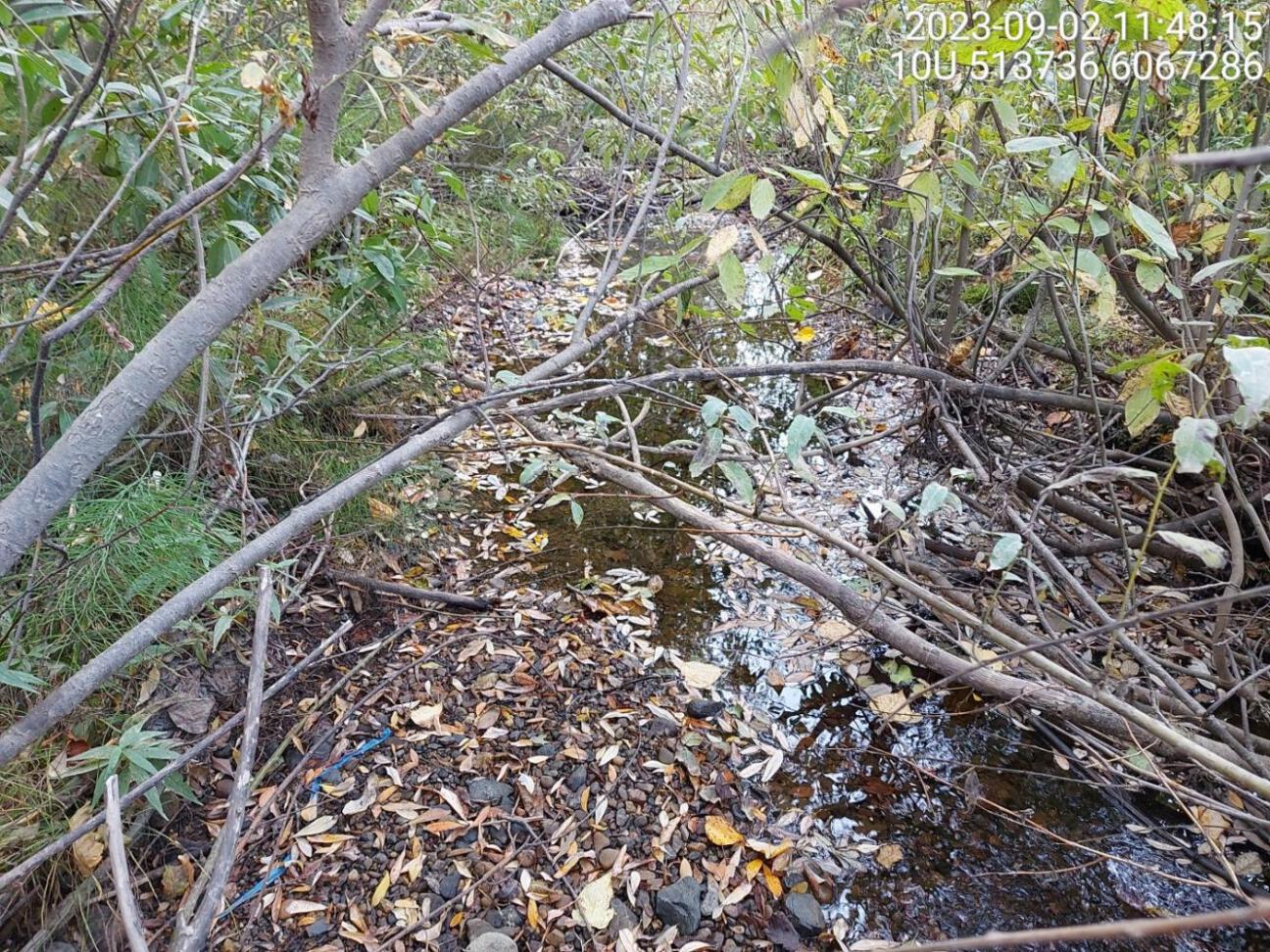
Figure 5.33: Typical habitat upstream of PSCIS crossing 198723 and downstream of 198694.
my_photo2 = fpr::fpr_photo_pull_by_str(site = my_site2, str_to_pull = '_ds_typical2')

my_caption2 = paste0('Typical habitat upstream of PSCIS crossing ', my_site, '.')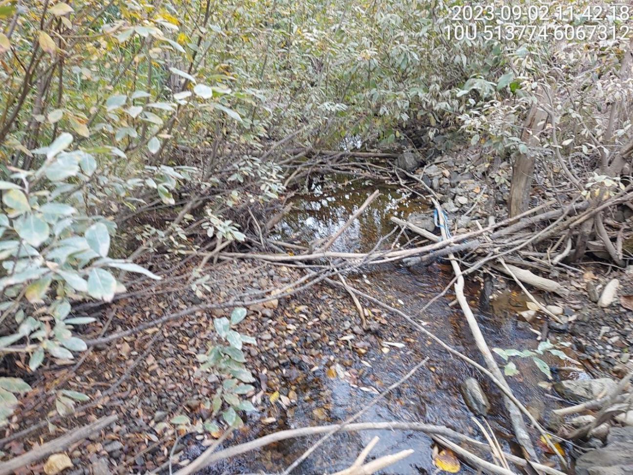
Figure 5.34: Typical habitat upstream of PSCIS crossing 198723.
my_caption <- paste0('Left: ', my_caption1, ' Right: ', my_caption2)

knitr::include_graphics(my_photo1)
knitr::include_graphics("fig/pixel.png")
knitr::include_graphics(my_photo2)
my_photo1 = fpr::fpr_photo_pull_by_str(site = my_site2, str_to_pull = '_us_typical1')
my_caption1 = paste0('Typical habitat upstream of PSCIS crossing ', my_site2, '.')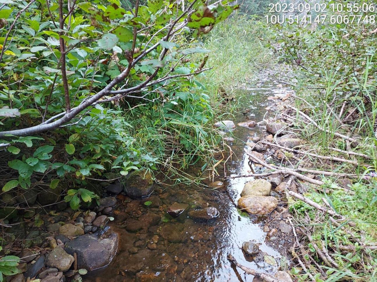
Figure 5.35: Typical habitat upstream of PSCIS crossing 198694.
my_photo2 = fpr::fpr_photo_pull_by_str(site = my_site2, str_to_pull = '_us_typical2')

my_caption2 = paste0('Typical habitat upstream of PSCIS crossing ', my_site2, '.')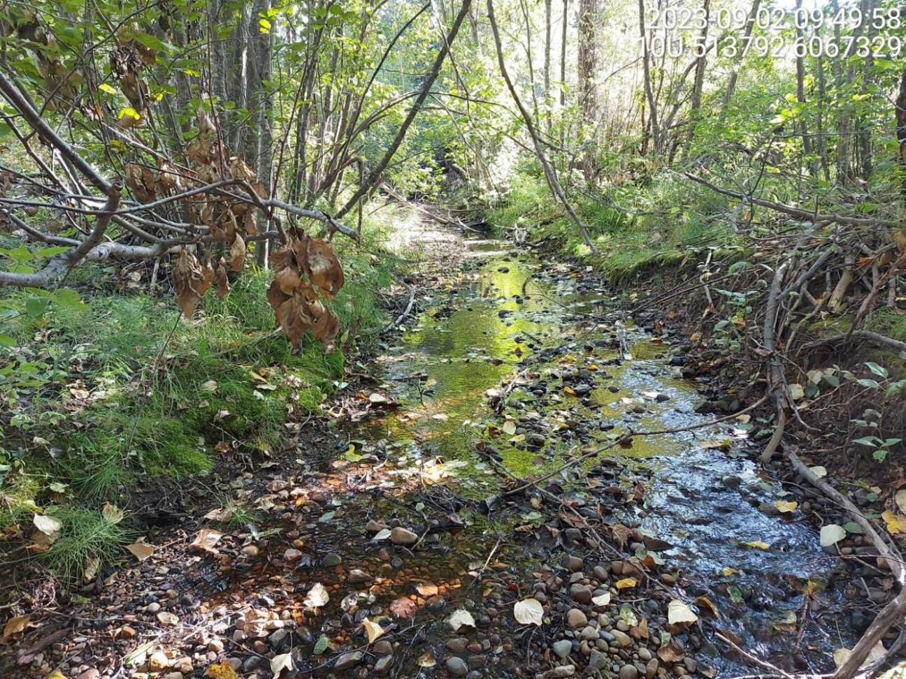
Figure 5.36: Typical habitat upstream of PSCIS crossing 198694.