Appendix - Phase 1 Fish Passage Assessment Data and Photos
| Location and Stream Data |
|
Crossing Characteristics | – |
|---|---|---|---|
| Date | 2023-09-25 | Crossing Sub Type | Round Culvert |
| PSCIS ID | 198906 | Diameter (m) | 1.6 |
| External ID | 8300003 | Length (m) | 20 |
| Crew | MW | Embedded | No |
| UTM Zone | 9 | Depth Embedded (m) | – |
| Easting | 585140 | Resemble Channel | No |
| Northing | 6119115 | Backwatered | No |
| Stream | Chicago Creek | Percent Backwatered | – |
| Road | Highway 16 | Fill Depth (m) | 4 |
| Road Tenure | MOTI | Outlet Drop (m) | 0.2 |
| Channel Width (m) | 3.9 | Outlet Pool Depth (m) | 0.7 |
| Stream Slope (%) | 3 | Inlet Drop | No |
| Beaver Activity | No | Slope (%) | 4.5 |
| Habitat Value | High | Valley Fill | Deep Fill |
| Final score | 34 | Barrier Result | Barrier |
| Fix type | Replace with New Open Bottom Structure | Fix Span / Diameter | 18 |
Photos: PSCIS ID 198906. From top left clockwise: Road/Site Card, Barrel, Outlet, Downstream, Upstream, Inlet.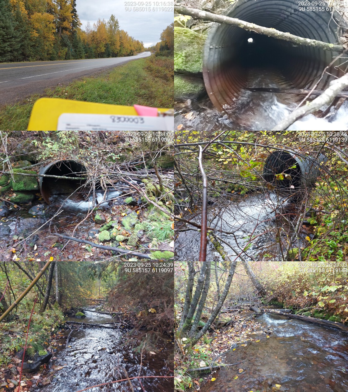
|
|||
| Comments: Small rapids near inlet creating small drop. Appears to be high stream velocity in culvert, installing baffles could be an option. Wide stream with high flow, gravels present upstream. Ministry of Transportation chris_culvert_id: 1522582. 10:42:03 |
| Location and Stream Data |
|
Crossing Characteristics | – |
|---|---|---|---|
| Date | 2023-09-25 | Crossing Sub Type | Round Culvert |
| PSCIS ID | 198907 | Diameter (m) | 0.75 |
| External ID | 8300013 | Length (m) | 8 |
| Crew | MW | Embedded | No |
| UTM Zone | 9 | Depth Embedded (m) | – |
| Easting | 581146 | Resemble Channel | No |
| Northing | 6115874 | Backwatered | No |
| Stream | Gershwin Creek | Percent Backwatered | – |
| Road | Braucher Rd | Fill Depth (m) | 1 |
| Road Tenure | MOTI Local | Outlet Drop (m) | 0 |
| Channel Width (m) | 2.1 | Outlet Pool Depth (m) | 0 |
| Stream Slope (%) | 3 | Inlet Drop | No |
| Beaver Activity | No | Slope (%) | 2 |
| Habitat Value | Low | Valley Fill | Deep Fill |
| Final score | 21 | Barrier Result | Barrier |
| Fix type | Replace with New Open Bottom Structure | Fix Span / Diameter | 15 |
Photos: PSCIS ID 198907. From top left clockwise: Road/Site Card, Barrel, Outlet, Downstream, Upstream, Inlet.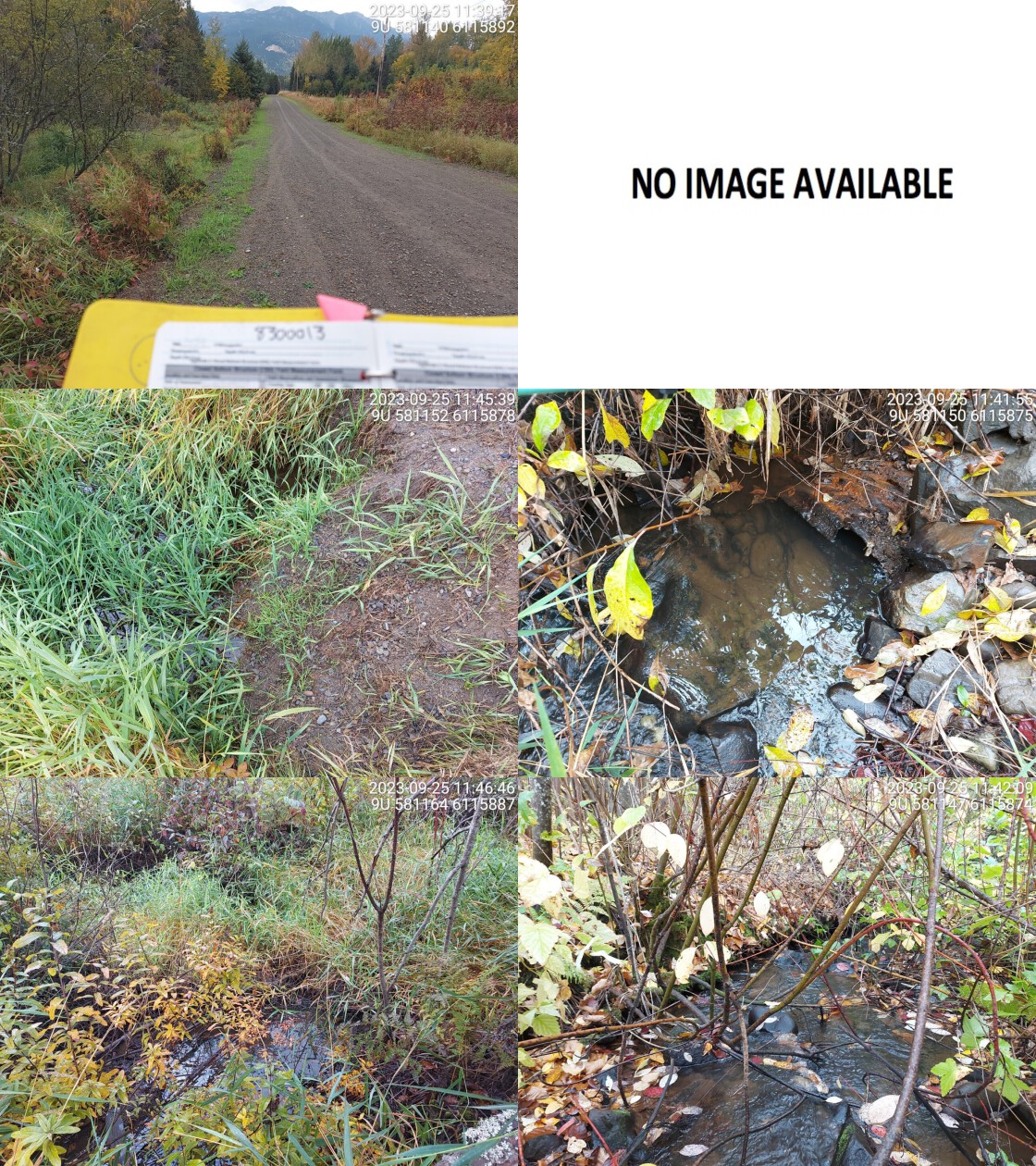
|
|||
| Comments: Culvert is barely visible, small part of outlet can be seen but the rest is buried and submerged in water. Inlet not visible. Pipe looks very old and in bad condition. Moderate flow downstream with well defined channel. Upstream channel is very overgrown and grassy vegetation. Culvert slope estimated. Wetland upstream. Ministry of Transportation chris_culvert_id: 1525550. 11:47:42 |
| Location and Stream Data |
|
Crossing Characteristics | – |
|---|---|---|---|
| Date | 2023-09-25 | Crossing Sub Type | Round Culvert |
| PSCIS ID | 198908 | Diameter (m) | 2 |
| External ID | 8300091 | Length (m) | 15 |
| Crew | MW | Embedded | No |
| UTM Zone | 9 | Depth Embedded (m) | – |
| Easting | 585181 | Resemble Channel | No |
| Northing | 6120192 | Backwatered | No |
| Stream | Tributary to Skeena River | Percent Backwatered | – |
| Road | Aldous St | Fill Depth (m) | 2.2 |
| Road Tenure | MOTI | Outlet Drop (m) | 0 |
| Channel Width (m) | 3.1 | Outlet Pool Depth (m) | 0 |
| Stream Slope (%) | 1 | Inlet Drop | No |
| Beaver Activity | No | Slope (%) | 1 |
| Habitat Value | Medium | Valley Fill | Deep Fill |
| Final score | 24 | Barrier Result | Barrier |
| Fix type | Replace with New Open Bottom Structure | Fix Span / Diameter | 15 |
Photos: PSCIS ID 198908. From top left clockwise: Road/Site Card, Barrel, Outlet, Downstream, Upstream, Inlet.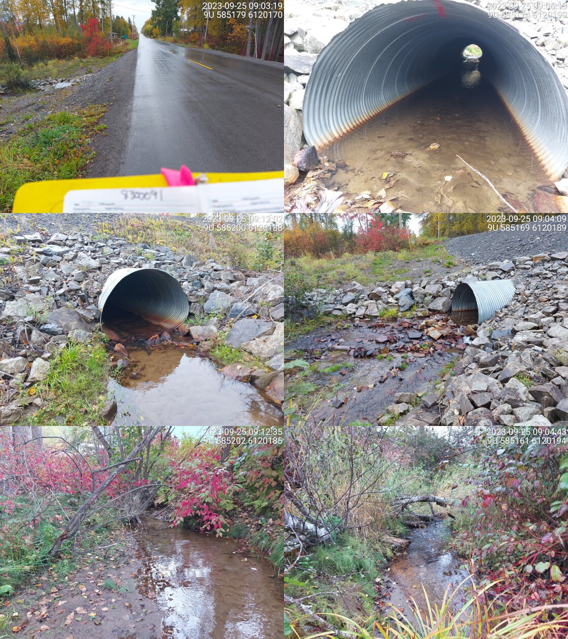
|
|||
| Comments: Good flowing stream, fry spotted in culvert and upstream. No outlet drop or pool. Some gravels downstream, only sand/fines upstream of culvert. Flows through residential area. Channel is wider upstream than downstream. Ministry of Transportation chris_culvert_id: 1525089. 09:08:22 |
| Location and Stream Data |
|
Crossing Characteristics | – |
|---|---|---|---|
| Date | 2023-09-25 | Crossing Sub Type | Round Culvert |
| PSCIS ID | 198909 | Diameter (m) | 0.9 |
| External ID | 8300094 | Length (m) | 32 |
| Crew | MW | Embedded | No |
| UTM Zone | 9 | Depth Embedded (m) | – |
| Easting | 578738 | Resemble Channel | No |
| Northing | 6113139 | Backwatered | No |
| Stream | Comeau Creek | Percent Backwatered | – |
| Road | Highway 16 | Fill Depth (m) | 3 |
| Road Tenure | MOTI | Outlet Drop (m) | 0 |
| Channel Width (m) | 0.9 | Outlet Pool Depth (m) | 0 |
| Stream Slope (%) | 3 | Inlet Drop | No |
| Beaver Activity | No | Slope (%) | 2 |
| Habitat Value | Low | Valley Fill | Deep Fill |
| Final score | 24 | Barrier Result | Barrier |
| Fix type | Replace Structure with Streambed Simulation CBS | Fix Span / Diameter | 3 |
Photos: PSCIS ID 198909. From top left clockwise: Road/Site Card, Barrel, Outlet, Downstream, Upstream, Inlet.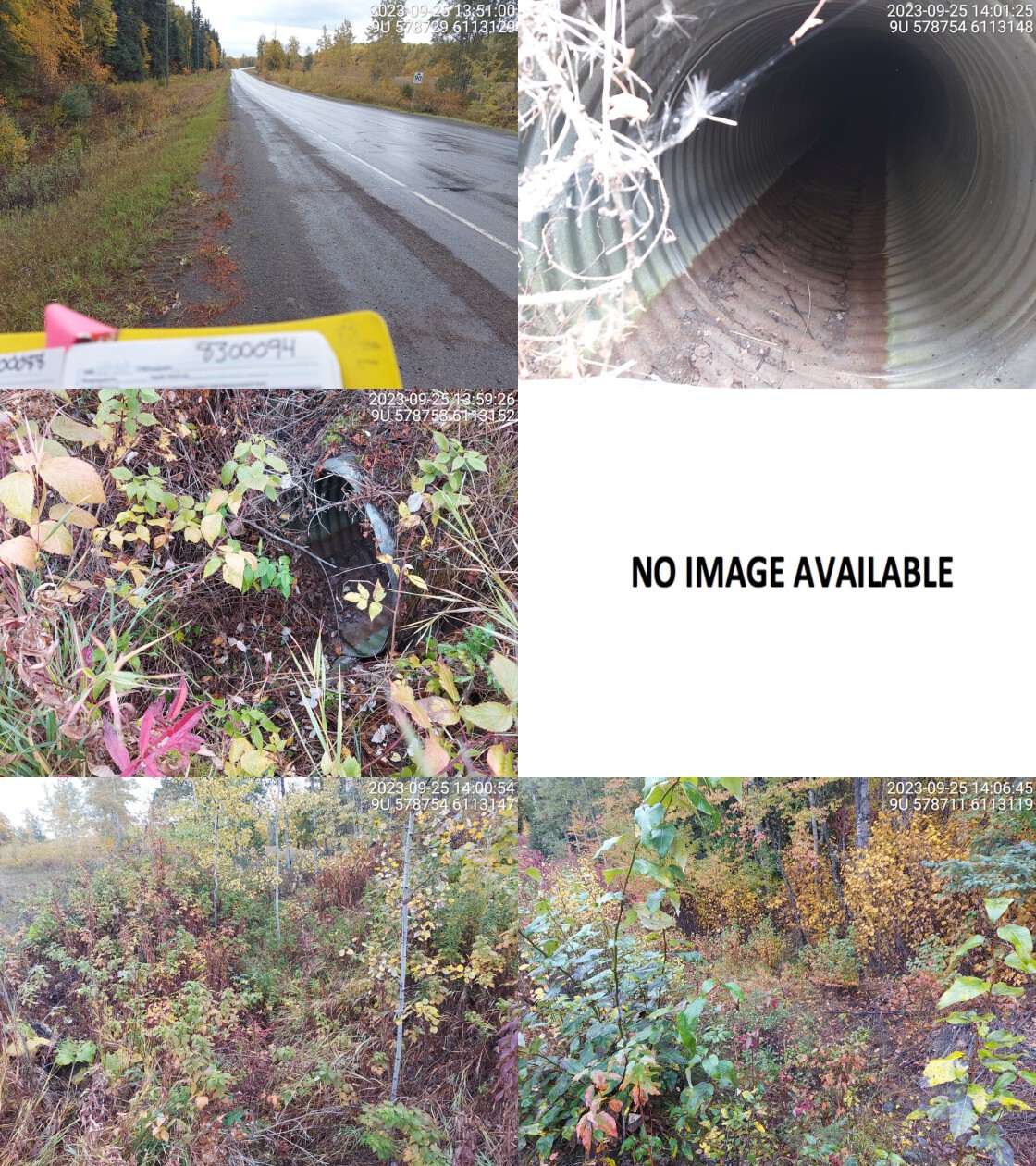
|
|||
| Comments: Dewatered stream, very small channel upstream, overgrown and poorly defined. Outlet could not be found. No visible channel downstream. Ministry of Transportation chris_culvert_id: 1522940. 14:08:23 |
| Location and Stream Data |
|
Crossing Characteristics | – |
|---|---|---|---|
| Date | 2023-09-25 | Crossing Sub Type | Oval Culvert |
| PSCIS ID | 198910 | Diameter (m) | 4.5 |
| External ID | 8300157 | Length (m) | 28 |
| Crew | AI | Embedded | No |
| UTM Zone | 9 | Depth Embedded (m) | – |
| Easting | 562494 | Resemble Channel | No |
| Northing | 6105029 | Backwatered | No |
| Stream | Shandilla Creek | Percent Backwatered | – |
| Road | Highway 16 | Fill Depth (m) | 4 |
| Road Tenure | MOTI | Outlet Drop (m) | 2 |
| Channel Width (m) | 5.8 | Outlet Pool Depth (m) | 0.4 |
| Stream Slope (%) | 8 | Inlet Drop | Yes |
| Beaver Activity | No | Slope (%) | 5.5 |
| Habitat Value | High | Valley Fill | Deep Fill |
| Final score | 36 | Barrier Result | Barrier |
| Fix type | Replace with New Open Bottom Structure | Fix Span / Diameter | 18 |
Photos: PSCIS ID 198910. From top left clockwise: Road/Site Card, Barrel, Outlet, Downstream, Upstream, Inlet.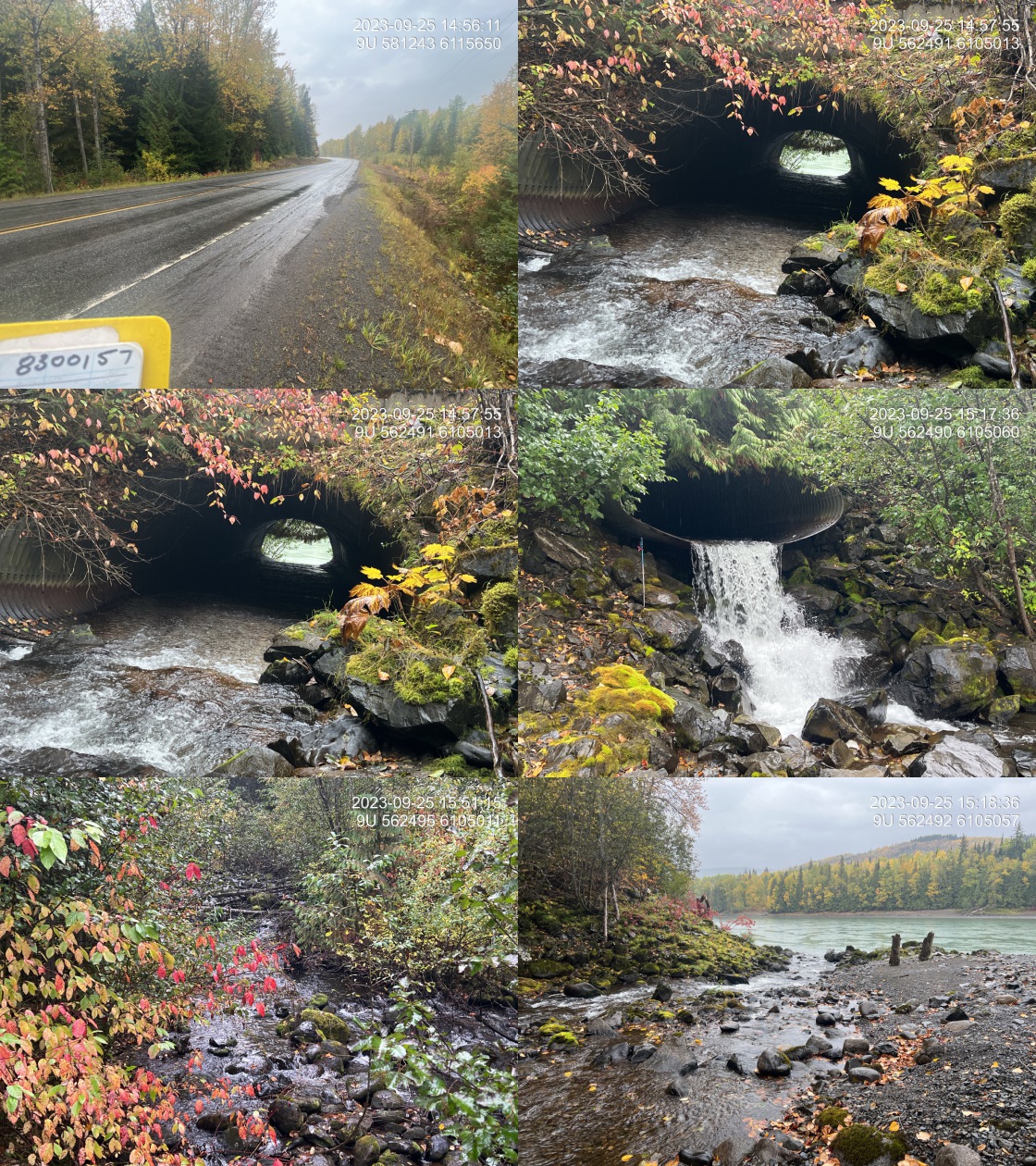
|
|||
| Comments: Very large stream with massive outlet drop on the pipe. Slight gradient change within the pipe for the last one and a half metres before the outlet as it is a bit steeper. Skeena river is immediately downstream of the outlet. Pink salmon spawning location noted upstream of the site. Two rock FISS obstacles noted upstream should be investigated. Ministry of Transportation chris_hwy_structure_road_id: 4100. 15:23:46 |
| Location and Stream Data |
|
Crossing Characteristics | – |
|---|---|---|---|
| Date | 2023-09-25 | Crossing Sub Type | Round Culvert |
| PSCIS ID | 198911 | Diameter (m) | 1.25 |
| External ID | 8300756 | Length (m) | 34 |
| Crew | MW | Embedded | No |
| UTM Zone | 9 | Depth Embedded (m) | – |
| Easting | 585631 | Resemble Channel | No |
| Northing | 6120092 | Backwatered | No |
| Stream | Tributary to Skeena River | Percent Backwatered | – |
| Road | Highway 16 | Fill Depth (m) | 6 |
| Road Tenure | MOTI | Outlet Drop (m) | 0.2 |
| Channel Width (m) | 2.4 | Outlet Pool Depth (m) | 0.3 |
| Stream Slope (%) | 2 | Inlet Drop | No |
| Beaver Activity | No | Slope (%) | 0.5 |
| Habitat Value | Medium | Valley Fill | Deep Fill |
| Final score | 27 | Barrier Result | Barrier |
| Fix type | Replace Structure with Streambed Simulation CBS | Fix Span / Diameter | 4.5 |
Photos: PSCIS ID 198911. From top left clockwise: Road/Site Card, Barrel, Outlet, Downstream, Upstream, Inlet.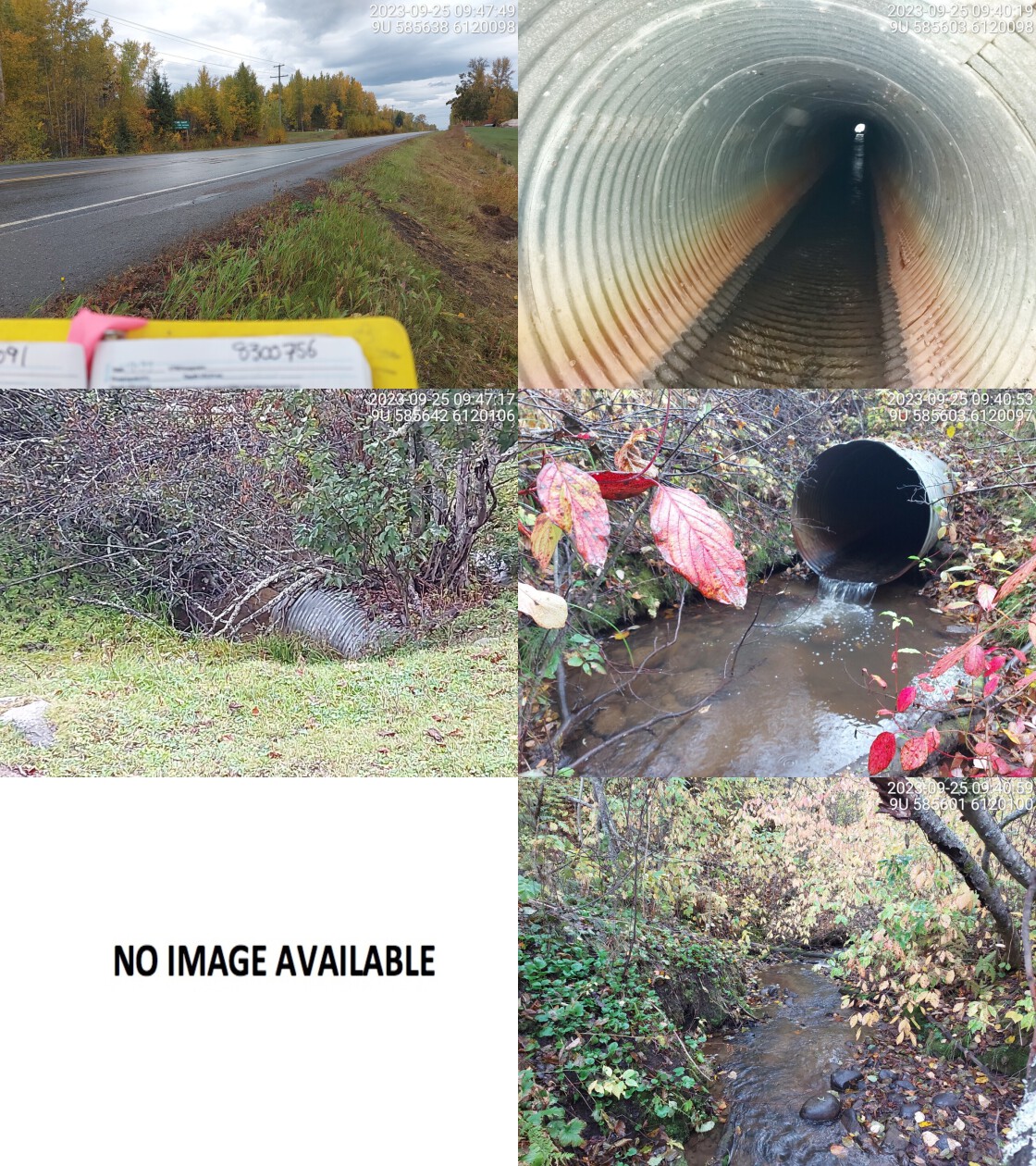
|
|||
| Comments: Very long culvert. Small road/trail between highway and outlet, culvert runs underneath both. Upstream side is in fenced off agricultural field, could not access. Lots of fines/sands in stream bed. Some gravels and cobbles. Good flow in culvert. Outlet drop estimated from photos as recorded 5cm appears erroneous. Historic CT FISS sites upstream and downstream as well as fry spotted during assessment of downstream crossing. Ministry of Transportation chris_culvert_id: 1522604. 09:32:36 |
| Location and Stream Data |
|
Crossing Characteristics | – |
|---|---|---|---|
| Date | 2023-09-25 | Crossing Sub Type | Round Culvert |
| PSCIS ID | 198912 | Diameter (m) | 1.8 |
| External ID | 8300759 | Length (m) | 22 |
| Crew | MW | Embedded | No |
| UTM Zone | 9 | Depth Embedded (m) | – |
| Easting | 584965 | Resemble Channel | No |
| Northing | 6118989 | Backwatered | No |
| Stream | Tributary to Chicago Creek | Percent Backwatered | – |
| Road | Highway 16 | Fill Depth (m) | 1.6 |
| Road Tenure | MOTI | Outlet Drop (m) | 0 |
| Channel Width (m) | 2.3 | Outlet Pool Depth (m) | 0 |
| Stream Slope (%) | 3.5 | Inlet Drop | No |
| Beaver Activity | Yes | Slope (%) | 0.5 |
| Habitat Value | Medium | Valley Fill | Deep Fill |
| Final score | 16 | Barrier Result | Potential |
| Fix type | Replace with New Open Bottom Structure | Fix Span / Diameter | 15 |
Photos: PSCIS ID 198912. From top left clockwise: Road/Site Card, Barrel, Outlet, Downstream, Upstream, Inlet.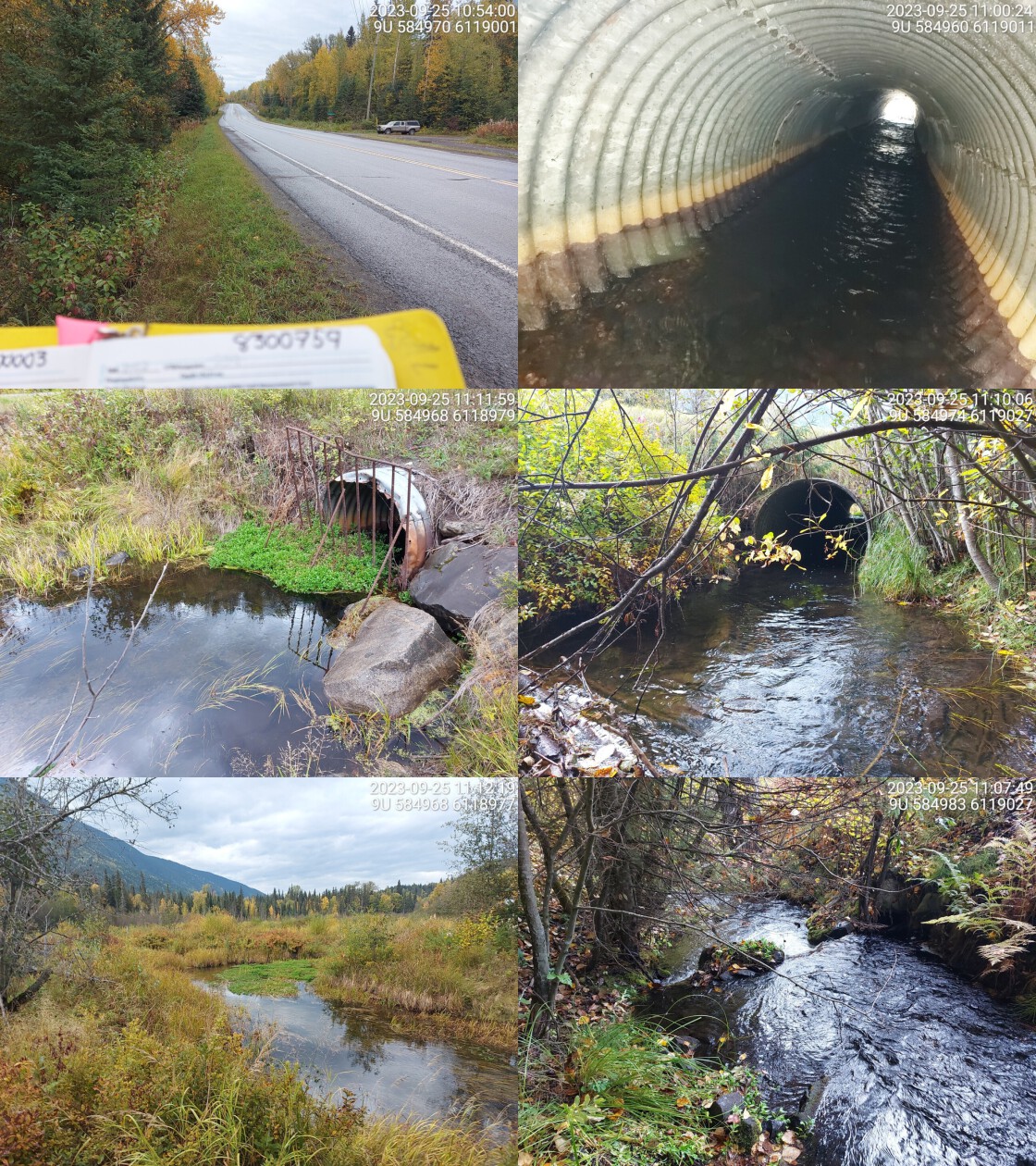
|
|||
| Comments: Relatively wide channel with high flow. Wetland habitat upstream. Beaver grate at inlet, 0.25m wide between vertical metal rods so still passable to all fish. Some stream substrate and cobbles present in culvert. Historic CT, DV, and RB FISS sites upstream and downstream. Ministry of Transportation chris_culvert_id: 1522560. 11:13:12 |
| Location and Stream Data |
|
Crossing Characteristics | – |
|---|---|---|---|
| Date | 2023-09-25 | Crossing Sub Type | Round Culvert |
| PSCIS ID | 198913 | Diameter (m) | 1.5 |
| External ID | 8300872 | Length (m) | 20 |
| Crew | MW | Embedded | No |
| UTM Zone | 9 | Depth Embedded (m) | – |
| Easting | 581259 | Resemble Channel | No |
| Northing | 6115642 | Backwatered | No |
| Stream | Tributary to Gershwin Creek | Percent Backwatered | – |
| Road | Highway 16 | Fill Depth (m) | 3 |
| Road Tenure | MOTI | Outlet Drop (m) | 0.4 |
| Channel Width (m) | 4.1 | Outlet Pool Depth (m) | 0.9 |
| Stream Slope (%) | 1.5 | Inlet Drop | No |
| Beaver Activity | No | Slope (%) | 2 |
| Habitat Value | High | Valley Fill | Deep Fill |
| Final score | 34 | Barrier Result | Barrier |
| Fix type | Replace with New Open Bottom Structure | Fix Span / Diameter | 15 |
Photos: PSCIS ID 198913. From top left clockwise: Road/Site Card, Barrel, Outlet, Downstream, Upstream, Inlet.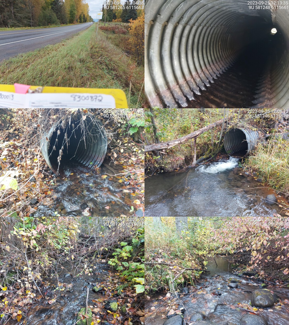
|
|||
| Comments: Fish spotted in outlet pool (approx. 40cm long). Good spawning gravels just downstream of outlet pool. Wide channel. Culvert has an outlet drop. Ministry of Transportation chris_culvert_id: 1522485. 12:19:12 |
| Location and Stream Data |
|
Crossing Characteristics | – |
|---|---|---|---|
| Date | 2023-09-25 | Crossing Sub Type | Round Culvert |
| PSCIS ID | 198914 | Diameter (m) | 1.5 |
| External ID | 8300970 | Length (m) | 20 |
| Crew | MW | Embedded | No |
| UTM Zone | 9 | Depth Embedded (m) | – |
| Easting | 569106 | Resemble Channel | No |
| Northing | 6105804 | Backwatered | No |
| Stream | Andimaul Creek | Percent Backwatered | – |
| Road | Highway 16 | Fill Depth (m) | 1.2 |
| Road Tenure | MOTI | Outlet Drop (m) | 1.6 |
| Channel Width (m) | 3.9 | Outlet Pool Depth (m) | 0.5 |
| Stream Slope (%) | 7 | Inlet Drop | No |
| Beaver Activity | No | Slope (%) | 5 |
| Habitat Value | High | Valley Fill | Deep Fill |
| Final score | 39 | Barrier Result | Barrier |
| Fix type | Replace with New Open Bottom Structure | Fix Span / Diameter | 15 |
Photos: PSCIS ID 198914. From top left clockwise: Road/Site Card, Barrel, Outlet, Downstream, Upstream, Inlet.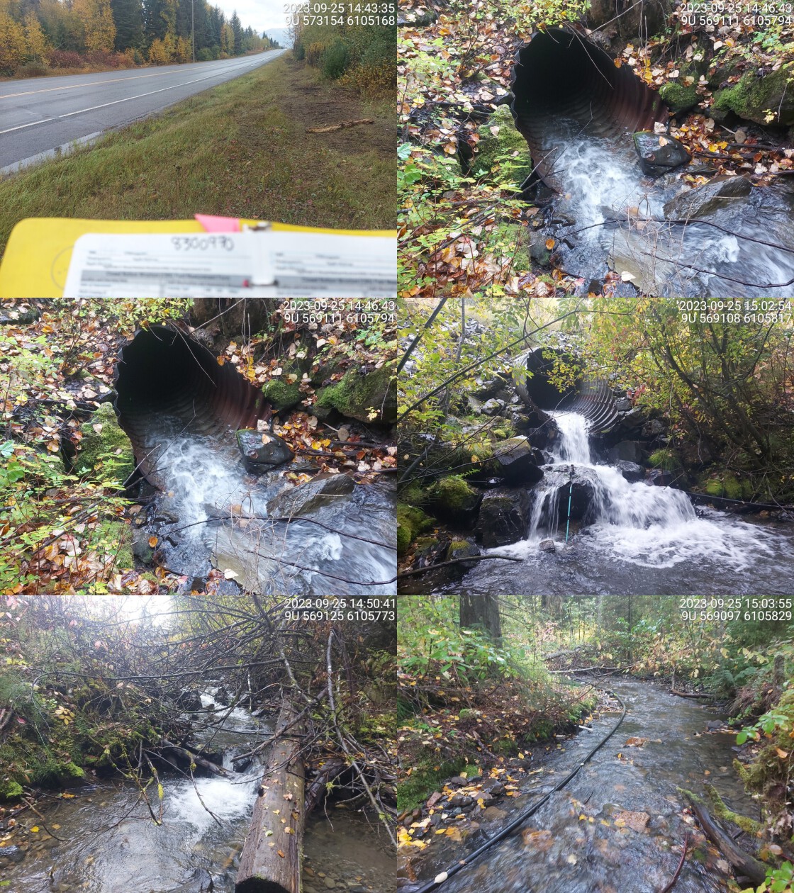
|
|||
| Comments: Massive outlet drop. Stream flows over big boulders before dropping down and creating large outlet pool. Some holes in culvert near end of pipe at outlet where water is flowing down through. High stream velocity in pipe. Nice stream with wide channel and high flow. Water line in stream downstream of crossing. Dolly Varden confirmed upstream of crossing.. 15:04:28 |
| Location and Stream Data |
|
Crossing Characteristics | – |
|---|---|---|---|
| Date | 2023-09-25 | Crossing Sub Type | Round Culvert |
| PSCIS ID | 198915 | Diameter (m) | 1.7 |
| External ID | 8302868 | Length (m) | 75 |
| Crew | AI | Embedded | No |
| UTM Zone | 9 | Depth Embedded (m) | – |
| Easting | 584388 | Resemble Channel | No |
| Northing | 6119507 | Backwatered | No |
| Stream | Chicago Creek | Percent Backwatered | – |
| Road | Railway | Fill Depth (m) | 9.9 |
| Road Tenure | CN Rail | Outlet Drop (m) | 1.2 |
| Channel Width (m) | 5 | Outlet Pool Depth (m) | 1 |
| Stream Slope (%) | 2 | Inlet Drop | Yes |
| Beaver Activity | No | Slope (%) | 2 |
| Habitat Value | High | Valley Fill | Deep Fill |
| Final score | 37 | Barrier Result | Barrier |
| Fix type | Replace with New Open Bottom Structure | Fix Span / Diameter | 35.5 |
Photos: PSCIS ID 198915. From top left clockwise: Road/Site Card, Barrel, Outlet, Downstream, Upstream, Inlet.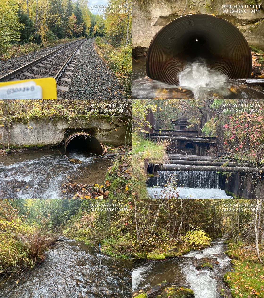
|
|||
| Comments: High value habitat. Major work has been done on this crossing to backwater the outlet using driven sheet pilings. There is an approximate 1.2 m high drop following 40 m of stream after the outlet where adult coho spawners are staged. Incredible spawning habitat upstream with low gradients and abundant gravels. Structure has the date 1920 stamped on the inlet. Known coho spawning system with long history and the Chicago creek restoration society putting in work for over 20 years. Fill depth estimated at 18 m, but changed to 9.9 to fulfill provincial sumbission requirements.. 11:06:50 |
| Location and Stream Data |
|
Crossing Characteristics | – |
|---|---|---|---|
| Date | 2023-09-25 | Crossing Sub Type | Concrete Box |
| PSCIS ID | 198916 | Diameter (m) | 1.5 |
| External ID | 8302869 | Length (m) | 99 |
| Crew | AI | Embedded | No |
| UTM Zone | 9 | Depth Embedded (m) | – |
| Easting | 580438 | Resemble Channel | No |
| Northing | 6115773 | Backwatered | No |
| Stream | Gershwin Creek | Percent Backwatered | – |
| Road | Railway | Fill Depth (m) | 9.9 |
| Road Tenure | CN Rail | Outlet Drop (m) | 0.4 |
| Channel Width (m) | 4.5 | Outlet Pool Depth (m) | 0.35 |
| Stream Slope (%) | 10 | Inlet Drop | No |
| Beaver Activity | No | Slope (%) | 7 |
| Habitat Value | High | Valley Fill | Deep Fill |
| Final score | 42 | Barrier Result | Barrier |
| Fix type | Replace with New Open Bottom Structure | Fix Span / Diameter | 35.5 |
Photos: PSCIS ID 198916. From top left clockwise: Road/Site Card, Barrel, Outlet, Downstream, Upstream, Inlet.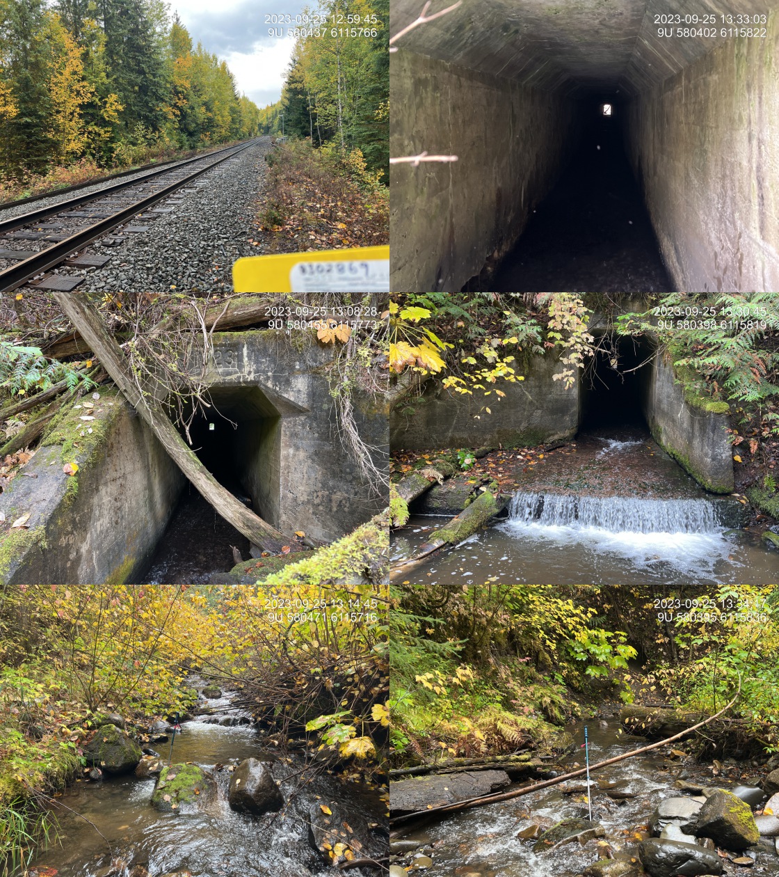
|
|||
| Comments: Very high value habitat upstream with pockets of gravel throughout. Adult cutthroat or rainbow observed just downstream of Highway 16 crossing upstream of here. Structure is dated 1923. Water flows within the box. Culvert at the time of the survey was approximately two to 5 cm deep. Skeena fisheries commission site with recommendation for installation of baffles. Fill depth estimated at 30 m and culvert length at 120 m, but changed to 9.9 and 99, respectively, in order to fulfill provincial sumbission requirements.. 13:35:25 |
| Location and Stream Data |
|
Crossing Characteristics | – |
|---|---|---|---|
| Date | 2023-09-25 | Crossing Sub Type | Round Culvert |
| PSCIS ID | 198917 | Diameter (m) | 1.5 |
| External ID | 8800020 | Length (m) | 22 |
| Crew | AI | Embedded | No |
| UTM Zone | 9 | Depth Embedded (m) | – |
| Easting | 543159 | Resemble Channel | No |
| Northing | 6096228 | Backwatered | No |
| Stream | Tributary to Skeena River | Percent Backwatered | – |
| Road | Cedarvale Rd | Fill Depth (m) | 4 |
| Road Tenure | MOTI | Outlet Drop (m) | 0 |
| Channel Width (m) | 1 | Outlet Pool Depth (m) | 0 |
| Stream Slope (%) | 2 | Inlet Drop | No |
| Beaver Activity | No | Slope (%) | 1 |
| Habitat Value | Low | Valley Fill | Deep Fill |
| Final score | 18 | Barrier Result | Potential |
| Fix type | Replace Structure with Streambed Simulation CBS | Fix Span / Diameter | 3 |
Photos: PSCIS ID 198917. From top left clockwise: Road/Site Card, Barrel, Outlet, Downstream, Upstream, Inlet.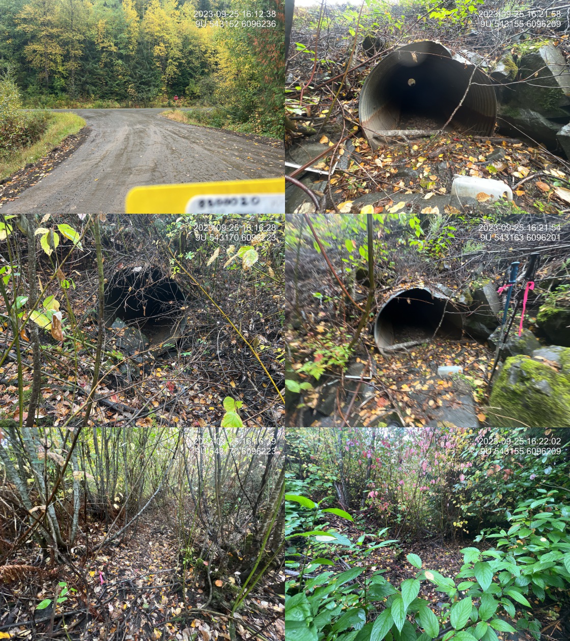
|
|||
| Comments: Dry at the time of survey. Well defined channel. Connects to a side channel of the Skeena River. Ministry of Transportation chris_culvert_id: 1528713. 16:13:26 |
| Location and Stream Data |
|
Crossing Characteristics | – |
|---|---|---|---|
| Date | 2023-09-26 | Crossing Sub Type | Round Culvert |
| PSCIS ID | 198918 | Diameter (m) | 2 |
| External ID | 8800026 | Length (m) | 42 |
| Crew | AI | Embedded | No |
| UTM Zone | 9 | Depth Embedded (m) | – |
| Easting | 538520 | Resemble Channel | No |
| Northing | 6050845 | Backwatered | No |
| Stream | Singlehurst Creek | Percent Backwatered | – |
| Road | Highway 16 | Fill Depth (m) | 6 |
| Road Tenure | MOTI | Outlet Drop (m) | 0.4 |
| Channel Width (m) | 5.7 | Outlet Pool Depth (m) | 1.2 |
| Stream Slope (%) | 1 | Inlet Drop | No |
| Beaver Activity | No | Slope (%) | 2.5 |
| Habitat Value | High | Valley Fill | Deep Fill |
| Final score | 37 | Barrier Result | Barrier |
| Fix type | Replace with New Open Bottom Structure | Fix Span / Diameter | 24 |
Photos: PSCIS ID 198918. From top left clockwise: Road/Site Card, Barrel, Outlet, Downstream, Upstream, Inlet.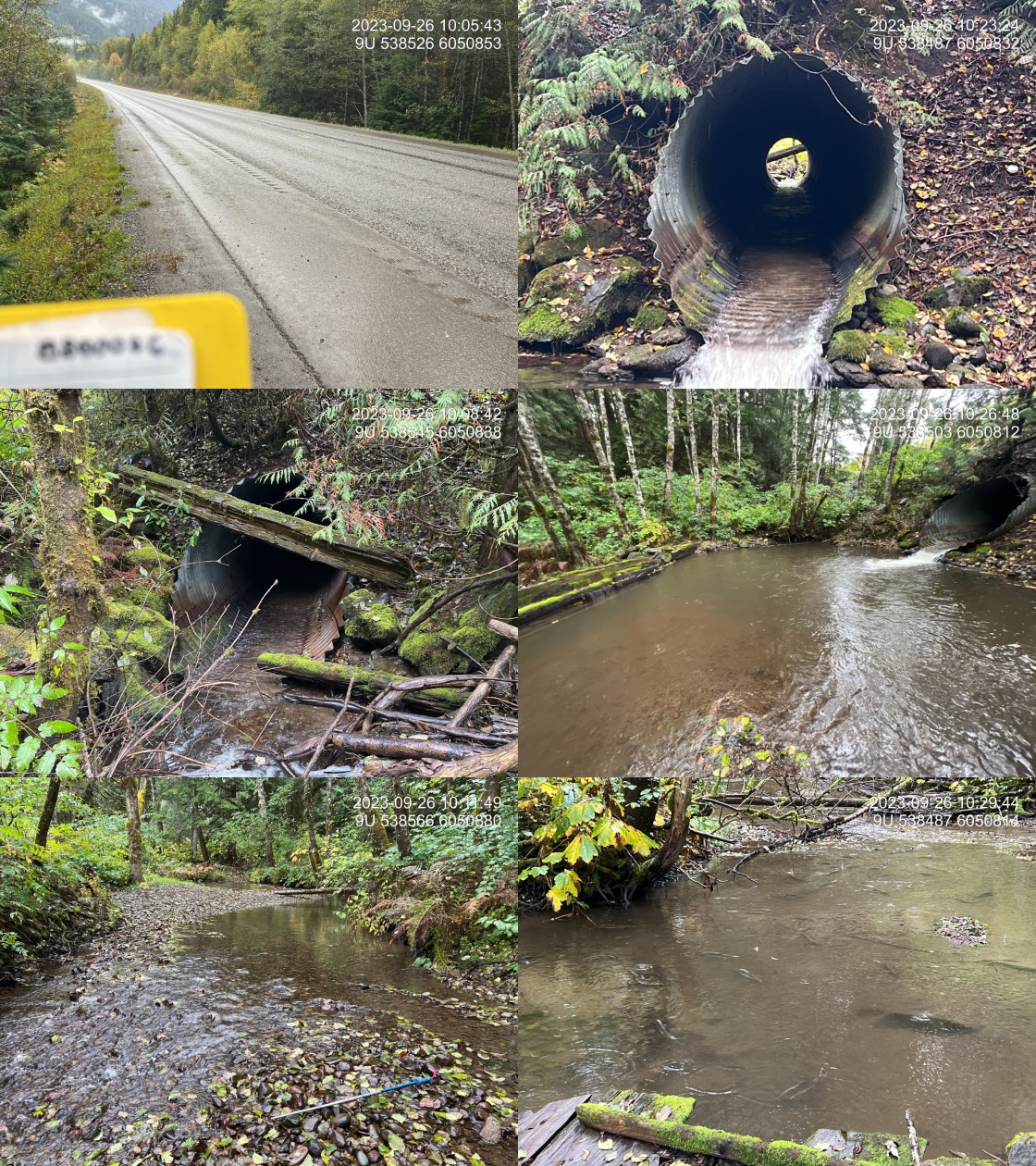
|
|||
| Comments: High value spawning habitat upstream. One redd observed upstream. DFO and MOTI historic back watering and side channel sites. Approximately 30 pink salmon spawners and 10 steelhead spawners immediately downstream of the last wooden structure downstream of the pipe. Crossing in is Kleanza Creek Provincial Park. Ministry of Transportation chris_hwy_structure_road_id: 192334. 10:06:21 |
| Location and Stream Data |
|
Crossing Characteristics | – |
|---|---|---|---|
| Date | 2023-09-26 | Crossing Sub Type | Round Culvert |
| PSCIS ID | 198919 | Diameter (m) | 3.1 |
| External ID | 8800047 | Length (m) | 22 |
| Crew | MW | Embedded | No |
| UTM Zone | 9 | Depth Embedded (m) | – |
| Easting | 539072 | Resemble Channel | No |
| Northing | 6051829 | Backwatered | No |
| Stream | Singlehurst Creek | Percent Backwatered | – |
| Road | Singlehurst Rd | Fill Depth (m) | 1 |
| Road Tenure | MOTI Local | Outlet Drop (m) | 0.2 |
| Channel Width (m) | 4.6 | Outlet Pool Depth (m) | 0.7 |
| Stream Slope (%) | 2.5 | Inlet Drop | No |
| Beaver Activity | No | Slope (%) | 3 |
| Habitat Value | High | Valley Fill | Deep Fill |
| Final score | 34 | Barrier Result | Barrier |
| Fix type | Replace with New Open Bottom Structure | Fix Span / Diameter | 15 |
Photos: PSCIS ID 198919. From top left clockwise: Road/Site Card, Barrel, Outlet, Downstream, Upstream, Inlet.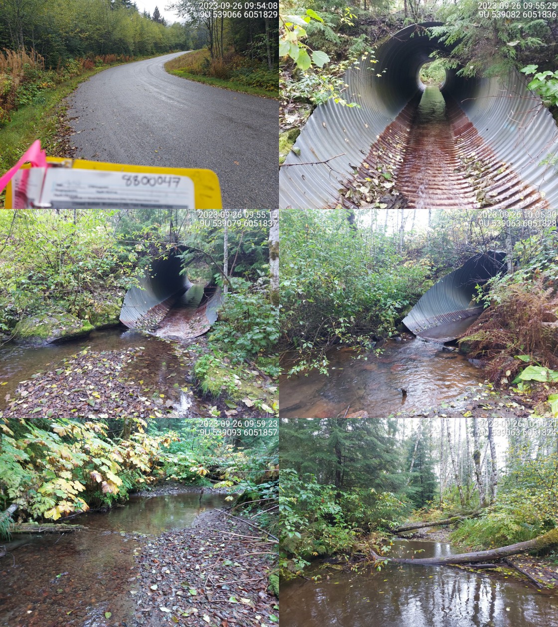
|
|||
| Comments: Abundant gravels present upstream. Very wide channel with good flow. Minimal outlet drop but deep pool. Historic steelhead and coho point upstream.. 10:10:43 |
| Location and Stream Data |
|
Crossing Characteristics | – |
|---|---|---|---|
| Date | 2023-09-26 | Crossing Sub Type | Round Culvert |
| PSCIS ID | 198920 | Diameter (m) | 1 |
| External ID | 8800056 | Length (m) | 24 |
| Crew | MW | Embedded | No |
| UTM Zone | 9 | Depth Embedded (m) | – |
| Easting | 537940 | Resemble Channel | No |
| Northing | 6048485 | Backwatered | No |
| Stream | Noble Five Creek | Percent Backwatered | – |
| Road | Highway 16 | Fill Depth (m) | 5 |
| Road Tenure | MOTI | Outlet Drop (m) | 1.6 |
| Channel Width (m) | 2.1 | Outlet Pool Depth (m) | 0.5 |
| Stream Slope (%) | 5 | Inlet Drop | No |
| Beaver Activity | No | Slope (%) | 4 |
| Habitat Value | Medium | Valley Fill | Deep Fill |
| Final score | 39 | Barrier Result | Barrier |
| Fix type | Replace with New Open Bottom Structure | Fix Span / Diameter | 21 |
Photos: PSCIS ID 198920. From top left clockwise: Road/Site Card, Barrel, Outlet, Downstream, Upstream, Inlet.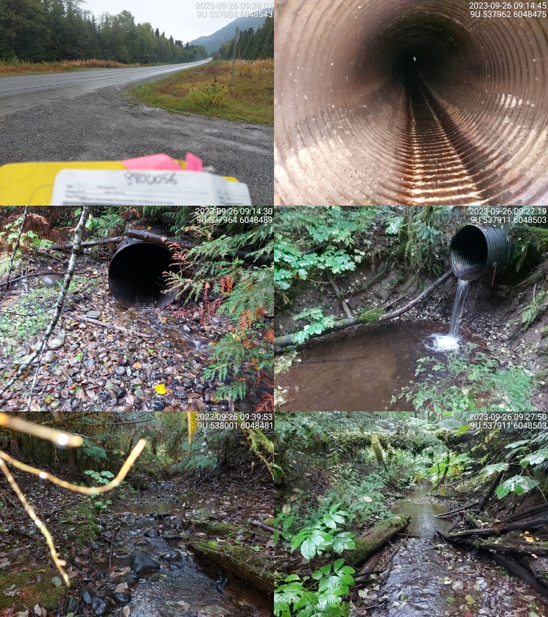
|
|||
| Comments: High fill depth and massive outlet drop. Pipe is bent sideways in the middle, can barely see the other side from inlet. Moderate flow in stream. Ministry of Transportation chris_culvert_id: 1923309. 09:17:20 |
| Location and Stream Data |
|
Crossing Characteristics | – |
|---|---|---|---|
| Date | 2023-09-26 | Crossing Sub Type | Round Culvert |
| PSCIS ID | 198921 | Diameter (m) | 2.5 |
| External ID | 8800070 | Length (m) | 24 |
| Crew | AI | Embedded | No |
| UTM Zone | 9 | Depth Embedded (m) | – |
| Easting | 536437 | Resemble Channel | No |
| Northing | 6046473 | Backwatered | No |
| Stream | Fall Creek | Percent Backwatered | – |
| Road | Highway 16 | Fill Depth (m) | 1 |
| Road Tenure | MOTI | Outlet Drop (m) | 1.6 |
| Channel Width (m) | 5.6 | Outlet Pool Depth (m) | 1.4 |
| Stream Slope (%) | 6.5 | Inlet Drop | Yes |
| Beaver Activity | No | Slope (%) | 1.5 |
| Habitat Value | High | Valley Fill | Deep Fill |
| Final score | 34 | Barrier Result | Barrier |
| Fix type | Replace with New Open Bottom Structure | Fix Span / Diameter | 15 |
Photos: PSCIS ID 198921. From top left clockwise: Road/Site Card, Barrel, Outlet, Downstream, Upstream, Inlet.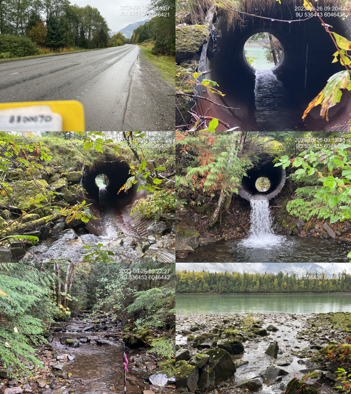
|
|||
| Comments: Outlet of pipe is almost at high watermark of the Skeena. Suspect that elevation of the pipe may need to consider high water levels for the Skeena. However, normal high water level is not much higher than outlet pool surface level at time of the survey so outlet drop is nearly always elevated. Large stream with good flow. Coho observed upstream in FISS. Crossing upstream has completely blown out. Ministry of Transportation chris_culvert_id: 1923295. 09:35:23 |
| Location and Stream Data |
|
Crossing Characteristics | – |
|---|---|---|---|
| Date | 2023-09-25 | Crossing Sub Type | Oval Culvert |
| PSCIS ID | 198922 | Diameter (m) | 4.8 |
| External ID | 8800072 | Length (m) | 22 |
| Crew | MW | Embedded | No |
| UTM Zone | 9 | Depth Embedded (m) | – |
| Easting | 547000 | Resemble Channel | No |
| Northing | 6100104 | Backwatered | No |
| Stream | Tributary to Skeena River | Percent Backwatered | – |
| Road | Highway 16 | Fill Depth (m) | 0.2 |
| Road Tenure | MOTI | Outlet Drop (m) | 0.8 |
| Channel Width (m) | 6.4 | Outlet Pool Depth (m) | 0.8 |
| Stream Slope (%) | 6.5 | Inlet Drop | No |
| Beaver Activity | No | Slope (%) | 3 |
| Habitat Value | Medium | Valley Fill | Bedrock |
| Final score | 39 | Barrier Result | Barrier |
| Fix type | Replace with New Open Bottom Structure | Fix Span / Diameter | 15 |
Photos: PSCIS ID 198922. From top left clockwise: Road/Site Card, Barrel, Outlet, Downstream, Upstream, Inlet.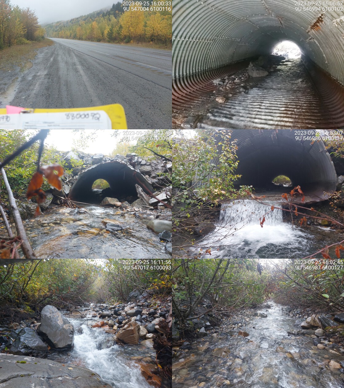
|
|||
| Comments: Big outlet drop and relatively deep pool. Big, wide culvert, some stream substrate in pipe but only on one side. Wide channel, high flow and steep system. Very low fill depth. Small fry seen in pipe. Ministry of Transportation chris_hwy_structure_road_id: 4099. 16:04:40 |
| Location and Stream Data |
|
Crossing Characteristics | – |
|---|---|---|---|
| Date | 2023-09-26 | Crossing Sub Type | Round Culvert |
| PSCIS ID | 198923 | Diameter (m) | 5 |
| External ID | 8800076 | Length (m) | 34 |
| Crew | MW | Embedded | No |
| UTM Zone | 9 | Depth Embedded (m) | – |
| Easting | 538964 | Resemble Channel | No |
| Northing | 6089976 | Backwatered | No |
| Stream | Flint Creek | Percent Backwatered | – |
| Road | Highway 16 | Fill Depth (m) | 8 |
| Road Tenure | MOTI | Outlet Drop (m) | 0 |
| Channel Width (m) | 6.8 | Outlet Pool Depth (m) | 0.3 |
| Stream Slope (%) | 5 | Inlet Drop | No |
| Beaver Activity | No | Slope (%) | 6 |
| Habitat Value | High | Valley Fill | Deep Fill |
| Final score | 32 | Barrier Result | Barrier |
| Fix type | Replace with New Open Bottom Structure | Fix Span / Diameter | 30 |
Photos: PSCIS ID 198923. From top left clockwise: Road/Site Card, Barrel, Outlet, Downstream, Upstream, Inlet.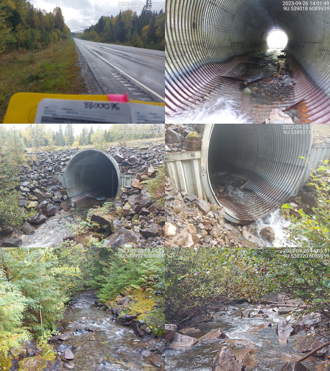
|
|||
| Comments: Massive pipe, wide stream with high flow. Baffles in pipe reducing stream velocity and allows fish to rest. Rainbow confirmed upstream and downstream. Ministry of Transportation chris_hwy_structure_road_id: 4098. 14:12:09 |
| Location and Stream Data |
|
Crossing Characteristics | – |
|---|---|---|---|
| Date | 2023-09-26 | Crossing Sub Type | Round Culvert |
| PSCIS ID | 198924 | Diameter (m) | 0.9 |
| External ID | 8800130 | Length (m) | 42 |
| Crew | MW | Embedded | No |
| UTM Zone | 9 | Depth Embedded (m) | – |
| Easting | 541520 | Resemble Channel | No |
| Northing | 6058092 | Backwatered | No |
| Stream | Tributary to Skeena River | Percent Backwatered | – |
| Road | Highway 16 | Fill Depth (m) | 8 |
| Road Tenure | MOTI | Outlet Drop (m) | 1 |
| Channel Width (m) | 1.6 | Outlet Pool Depth (m) | 0 |
| Stream Slope (%) | 1 | Inlet Drop | Yes |
| Beaver Activity | No | Slope (%) | 1 |
| Habitat Value | Low | Valley Fill | Deep Fill |
| Final score | 37 | Barrier Result | Barrier |
| Fix type | Replace Structure with Streambed Simulation CBS | Fix Span / Diameter | 3 |
Photos: PSCIS ID 198924. From top left clockwise: Road/Site Card, Barrel, Outlet, Downstream, Upstream, Inlet.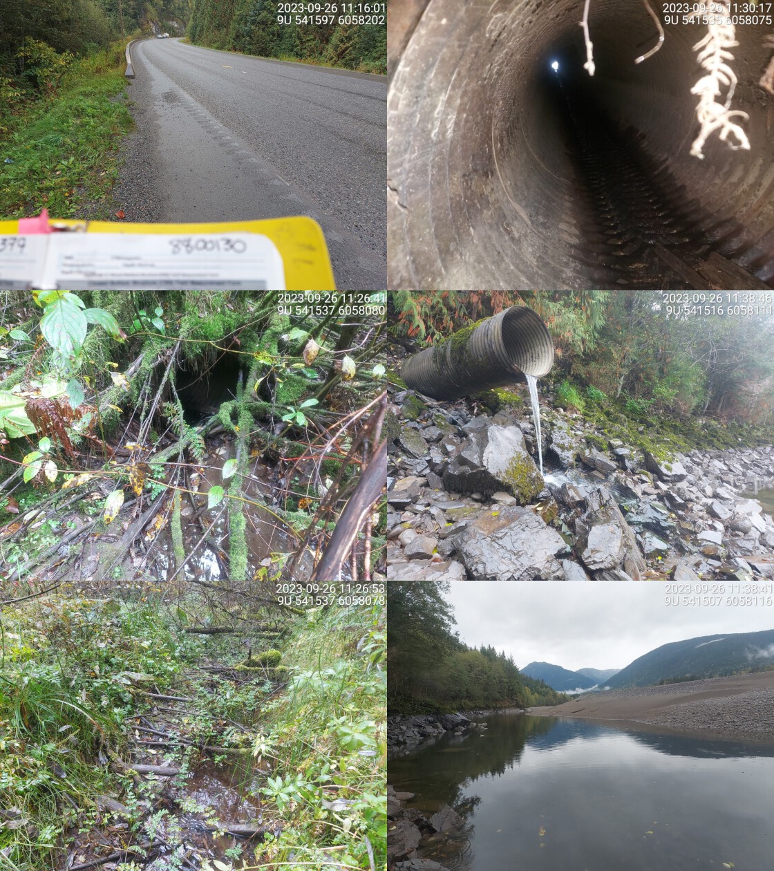
|
|||
| Comments: Big outlet drop to Skeena River channel. Could be accessible during high-water in river. Small channel upstream. Stream is flowing. Chinook sampled upstream in the past. Ministry of Transportation chris_culvert_id: 1923241. 11:29:54 |
| Location and Stream Data |
|
Crossing Characteristics | – |
|---|---|---|---|
| Date | 2023-09-26 | Crossing Sub Type | Round Culvert |
| PSCIS ID | 198925 | Diameter (m) | 1.5 |
| External ID | 8800140 | Length (m) | 24 |
| Crew | AI | Embedded | No |
| UTM Zone | 9 | Depth Embedded (m) | – |
| Easting | 545410 | Resemble Channel | No |
| Northing | 6075546 | Backwatered | No |
| Stream | Tributary to Skeena River | Percent Backwatered | – |
| Road | Highway 16 | Fill Depth (m) | 1.7 |
| Road Tenure | MOTI | Outlet Drop (m) | 0 |
| Channel Width (m) | 8 | Outlet Pool Depth (m) | 0 |
| Stream Slope (%) | 0 | Inlet Drop | No |
| Beaver Activity | Yes | Slope (%) | 0 |
| Habitat Value | Low | Valley Fill | Deep Fill |
| Final score | 19 | Barrier Result | Potential |
| Fix type | Replace with New Open Bottom Structure | Fix Span / Diameter | 15 |
Photos: PSCIS ID 198925. From top left clockwise: Road/Site Card, Barrel, Outlet, Downstream, Upstream, Inlet.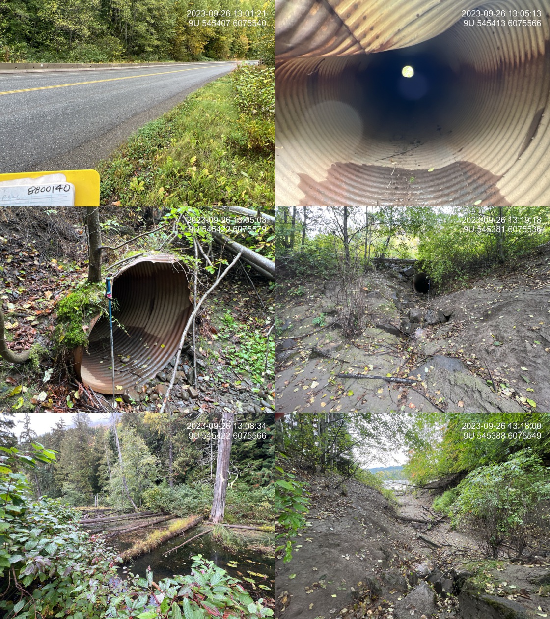
|
|||
| Comments: Beaver dam approximately 1.4 m high located 5 m upstream of the inlet. Beaver influenced wetland upstream however, stream was dry at time of survey downstream of the dam. Skeena River is immediately downstream of the outlet with the high water level approximately 2 m below pipe outlet. Culvert is in very poor condition with top side of the inlet bent down and pipe rusted all the way through the bottom for the last 2 m of pipe at outlet. The area upstream of the highway may historically have provided refuge in high flows, however, at time of survey water levels were low with water quite stagnant. Ministry of Transportation chris_culvert_id: 1923217. 13:00:04 |
| Location and Stream Data |
|
Crossing Characteristics | – |
|---|---|---|---|
| Date | 2023-09-26 | Crossing Sub Type | Round Culvert |
| PSCIS ID | 198926 | Diameter (m) | 0.6 |
| External ID | 8800144 | Length (m) | 18 |
| Crew | MW | Embedded | No |
| UTM Zone | 9 | Depth Embedded (m) | – |
| Easting | 542401 | Resemble Channel | No |
| Northing | 6078904 | Backwatered | No |
| Stream | Tributary to Skeena River | Percent Backwatered | – |
| Road | Highway 16 | Fill Depth (m) | 1 |
| Road Tenure | MOTI | Outlet Drop (m) | 0 |
| Channel Width (m) | 0.6 | Outlet Pool Depth (m) | 0 |
| Stream Slope (%) | 2 | Inlet Drop | No |
| Beaver Activity | No | Slope (%) | 2 |
| Habitat Value | Low | Valley Fill | Deep Fill |
| Final score | 21 | Barrier Result | Barrier |
| Fix type | Replace Structure with Streambed Simulation CBS | Fix Span / Diameter | 3 |
Photos: PSCIS ID 198926. From top left clockwise: Road/Site Card, Barrel, Outlet, Downstream, Upstream, Inlet.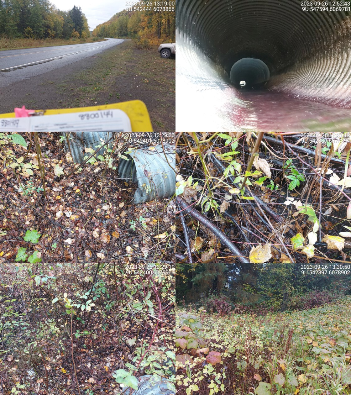
|
|||
| Comments: Dewatered, no defined stream channel found. Outlet barely visible. Ministry of Transportation chris_culvert_id: 1526980. 13:29:33 |
| Location and Stream Data |
|
Crossing Characteristics | – |
|---|---|---|---|
| Date | 2023-09-26 | Crossing Sub Type | Round Culvert |
| PSCIS ID | 198927 | Diameter (m) | 3.5 |
| External ID | 8800149 | Length (m) | 35 |
| Crew | AI | Embedded | No |
| UTM Zone | 9 | Depth Embedded (m) | – |
| Easting | 539719 | Resemble Channel | No |
| Northing | 6083274 | Backwatered | No |
| Stream | Tributary to Skeena River | Percent Backwatered | – |
| Road | Highway 16 | Fill Depth (m) | 4 |
| Road Tenure | MOTI | Outlet Drop (m) | 0 |
| Channel Width (m) | 10 | Outlet Pool Depth (m) | 1.4 |
| Stream Slope (%) | 10 | Inlet Drop | No |
| Beaver Activity | No | Slope (%) | 14 |
| Habitat Value | Medium | Valley Fill | Shallow Fill |
| Final score | 32 | Barrier Result | Barrier |
| Fix type | Replace with New Open Bottom Structure | Fix Span / Diameter | 18 |
Photos: PSCIS ID 198927. From top left clockwise: Road/Site Card, Barrel, Outlet, Downstream, Upstream, Inlet.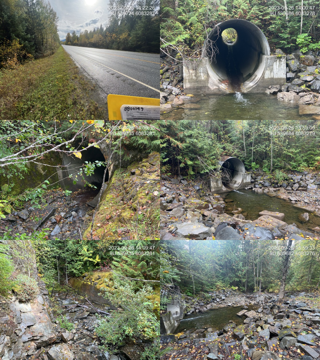
|
|||
| Comments: Major debris accumulation downstream of the culvert. Stream is dewatered downstream for at least 60 m. There are numerous buried concrete lock blocks downstream of the outlet which may have been part of a backwatering system. Trash rack upstream of the crossing has failed, with steel members scattered throughout the stream. There are poured concrete wing walls upstream of the crossing with the right bank being approximately 8 m long and river left bank wall at 30 m long. Bottom half of the culvert is concrete and the top half is corrugated metal. Steeper stream with step pool habitat and bedrock throughout the channel. Dolly Varden and cutthroat noted upstream in FISS. Ministry of Transportation chris_hwy_structure_road_id: 2351. 14:11:58 |
| Location and Stream Data |
|
Crossing Characteristics | – |
|---|---|---|---|
| Date | 2023-09-26 | Crossing Sub Type | Round Culvert |
| PSCIS ID | 198928 | Diameter (m) | 0.6 |
| External ID | 8801343 | Length (m) | 20 |
| Crew | AI | Embedded | Yes |
| UTM Zone | 9 | Depth Embedded (m) | 0.2 |
| Easting | 547458 | Resemble Channel | Yes |
| Northing | 6066323 | Backwatered | Yes |
| Stream | Tributary to Skeena River | Percent Backwatered | 50 |
| Road | Highway 16 | Fill Depth (m) | 1.5 |
| Road Tenure | MOTI | Outlet Drop (m) | 0 |
| Channel Width (m) | 1.7 | Outlet Pool Depth (m) | 0.25 |
| Stream Slope (%) | 1 | Inlet Drop | Yes |
| Beaver Activity | Yes | Slope (%) | 1 |
| Habitat Value | Low | Valley Fill | Deep Fill |
| Final score | 19 | Barrier Result | Potential |
| Fix type | Replace Structure with Streambed Simulation CBS | Fix Span / Diameter | 3 |
Photos: PSCIS ID 198928. From top left clockwise: Road/Site Card, Barrel, Outlet, Downstream, Upstream, Inlet.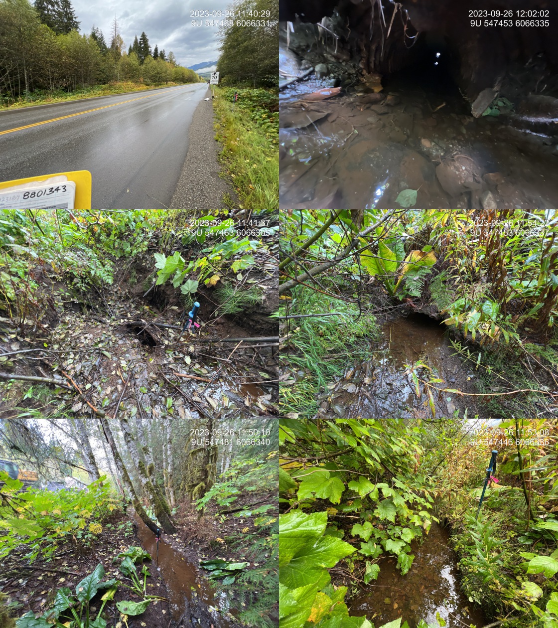
|
|||
| Comments: Small drainage with 1 m high beaver dam approximately 5 m upstream of the inlet. Fine substrate. Seems unlikely that the stream is fish bearing. Historic FISS stream sample site conducted with channel dry at the time of their assessment. Culvert is in very poor condition, rusting through and bent significantly on the outlet. Pipe slope estimated as deformed pipe and position made measurement with clinometer not possible. Ministry of Transportation chris_culvert_id: 1923189. 11:38:36 |
| Location and Stream Data |
|
Crossing Characteristics | – |
|---|---|---|---|
| Date | 2023-09-26 | Crossing Sub Type | Round Culvert |
| PSCIS ID | 198929 | Diameter (m) | 1 |
| External ID | 8801347 | Length (m) | 27 |
| Crew | AI | Embedded | Yes |
| UTM Zone | 9 | Depth Embedded (m) | 0.4 |
| Easting | 547255 | Resemble Channel | Yes |
| Northing | 6066045 | Backwatered | Yes |
| Stream | Tributary to Skeena River | Percent Backwatered | 70 |
| Road | Highway 16 | Fill Depth (m) | 3.7 |
| Road Tenure | MOTI | Outlet Drop (m) | 0 |
| Channel Width (m) | 2.8 | Outlet Pool Depth (m) | 0.25 |
| Stream Slope (%) | 2 | Inlet Drop | Yes |
| Beaver Activity | Yes | Slope (%) | 1.5 |
| Habitat Value | Medium | Valley Fill | Deep Fill |
| Final score | 14 | Barrier Result | Passable |
| Fix type | – | Fix Span / Diameter | – |
Photos: PSCIS ID 198929. From top left clockwise: Road/Site Card, Barrel, Outlet, Downstream, Upstream, Inlet.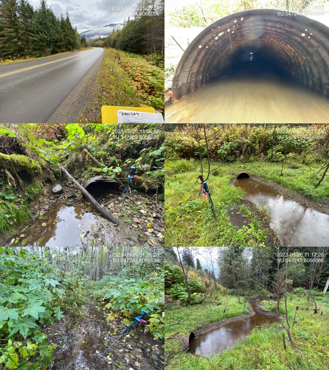
|
|||
| Comments: Most of the inlet is blocked with accumulating fines upstream. Pipe is in very poor condition and starting to rust right through on the downstream end. Dolly Varden and rainbow known upstream in FISS. Lots of beaver activity at the outlet. Small stream with mostly fine substrate immediately upstream and downstream of the highway. Ministry of Transportation chris_culvert_id: 1923190. 11:07:49 |
| Location and Stream Data |
|
Crossing Characteristics | – |
|---|---|---|---|
| Date | 2023-09-26 | Crossing Sub Type | Round Culvert |
| PSCIS ID | 198930 | Diameter (m) | 1.5 |
| External ID | 8801379 | Length (m) | 30 |
| Crew | MW | Embedded | No |
| UTM Zone | 9 | Depth Embedded (m) | – |
| Easting | 538709 | Resemble Channel | No |
| Northing | 6054566 | Backwatered | No |
| Stream | Tributary to Skeena River | Percent Backwatered | – |
| Road | Highway 16 | Fill Depth (m) | 4 |
| Road Tenure | MOTI | Outlet Drop (m) | 0.2 |
| Channel Width (m) | 6.8 | Outlet Pool Depth (m) | 0 |
| Stream Slope (%) | 1 | Inlet Drop | No |
| Beaver Activity | No | Slope (%) | 1 |
| Habitat Value | Low | Valley Fill | Deep Fill |
| Final score | 32 | Barrier Result | Barrier |
| Fix type | Replace with New Open Bottom Structure | Fix Span / Diameter | 18 |
Photos: PSCIS ID 198930. From top left clockwise: Road/Site Card, Barrel, Outlet, Downstream, Upstream, Inlet.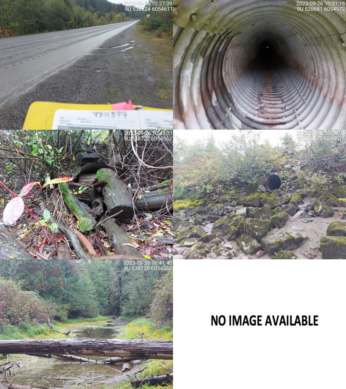
|
|||
| Comments: High distance from outlet of pipe to skeena wetted channel. Only accessible at high water. Big, wide wetland area just upstream of highway. Large woody debris blocking most of inlet. No water flowing through pipe. Some stagnant water upstream. Ministry of Transportation chris_culvert_id: 1923235. 10:31:02 |
| Location and Stream Data |
|
Crossing Characteristics | – |
|---|---|---|---|
| Date | 2023-09-26 | Crossing Sub Type | Round Culvert |
| PSCIS ID | 198931 | Diameter (m) | 0.9 |
| External ID | 8801406 | Length (m) | 21 |
| Crew | AI | Embedded | No |
| UTM Zone | 9 | Depth Embedded (m) | – |
| Easting | 547750 | Resemble Channel | No |
| Northing | 6068488 | Backwatered | No |
| Stream | Tributary to Skeena River | Percent Backwatered | – |
| Road | Highway 16 | Fill Depth (m) | 2.5 |
| Road Tenure | MOTI | Outlet Drop (m) | 0.9 |
| Channel Width (m) | 1.5 | Outlet Pool Depth (m) | 0.2 |
| Stream Slope (%) | 8.5 | Inlet Drop | No |
| Beaver Activity | No | Slope (%) | 8 |
| Habitat Value | Medium | Valley Fill | Deep Fill |
| Final score | 39 | Barrier Result | Barrier |
| Fix type | Replace Structure with Streambed Simulation CBS | Fix Span / Diameter | 3 |
Photos: PSCIS ID 198931. From top left clockwise: Road/Site Card, Barrel, Outlet, Downstream, Upstream, Inlet.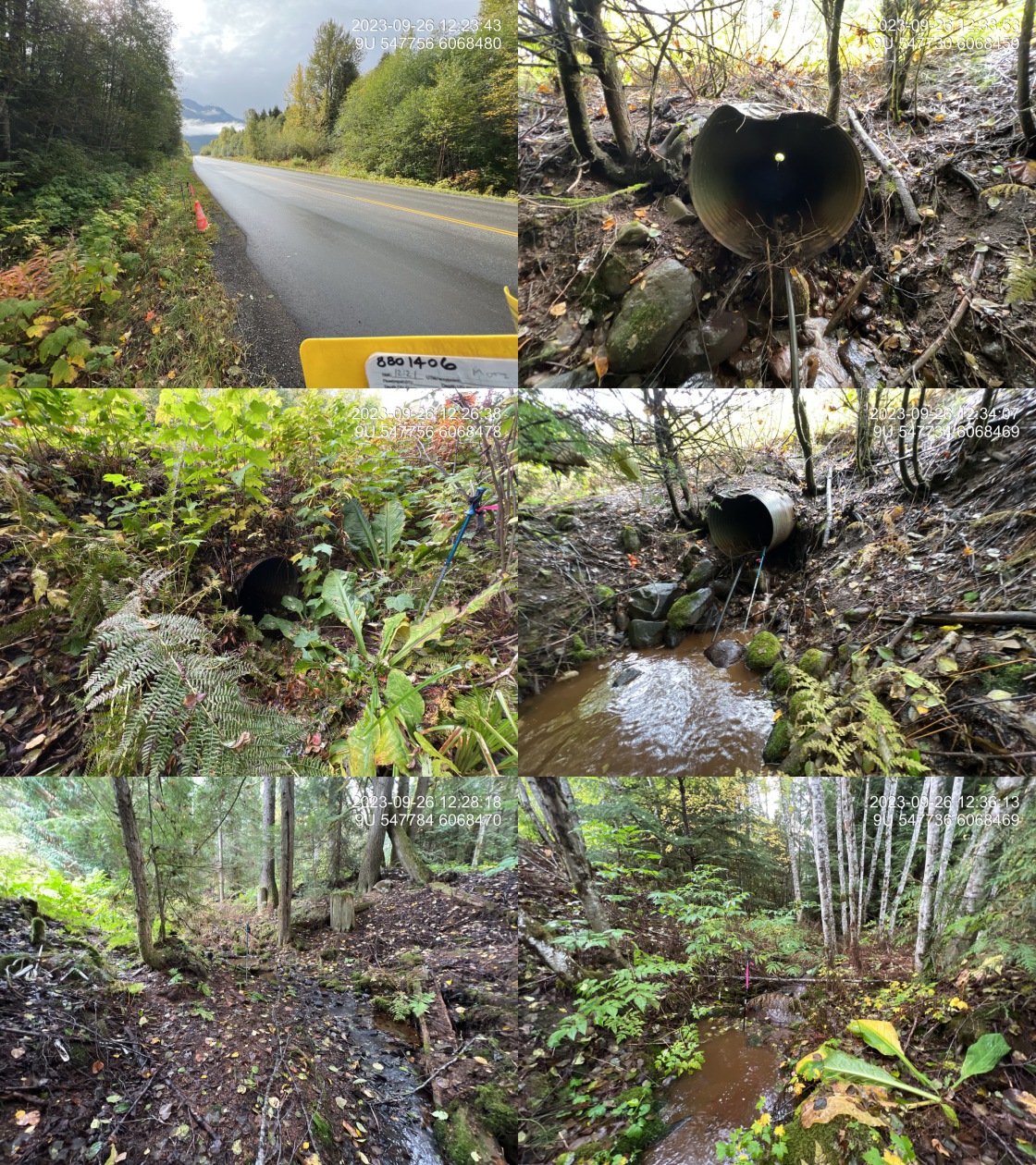
|
|||
| Comments: Historic rainbow point upstream of the highway. Small stream, dewaters (temporarily) 40 m upstream of the crossing. Pipe is in very bad condition and has bend from 13m in all the way to the outlet. Significant amounts of water leaking out of the bottom of the pipe and eroding the road prism at the outlet. Large outlet drop. Ministry of Transportation chris_culvert_id: 1923183. 12:24:21 |
| Location and Stream Data |
|
Crossing Characteristics | – |
|---|---|---|---|
| Date | 2023-09-26 | Crossing Sub Type | Round Culvert |
| PSCIS ID | 198932 | Diameter (m) | 1.5 |
| External ID | 8801409 | Length (m) | 40 |
| Crew | MW | Embedded | No |
| UTM Zone | 9 | Depth Embedded (m) | – |
| Easting | 547610 | Resemble Channel | No |
| Northing | 6069809 | Backwatered | No |
| Stream | Tributary to Skeena River | Percent Backwatered | – |
| Road | Highway 16 | Fill Depth (m) | 3 |
| Road Tenure | MOTI | Outlet Drop (m) | 2.2 |
| Channel Width (m) | 2.7 | Outlet Pool Depth (m) | 0.3 |
| Stream Slope (%) | 18 | Inlet Drop | Yes |
| Beaver Activity | No | Slope (%) | 4 |
| Habitat Value | Medium | Valley Fill | Deep Fill |
| Final score | 42 | Barrier Result | Barrier |
| Fix type | Replace with New Open Bottom Structure | Fix Span / Diameter | 15 |
Photos: PSCIS ID 198932. From top left clockwise: Road/Site Card, Barrel, Outlet, Downstream, Upstream, Inlet.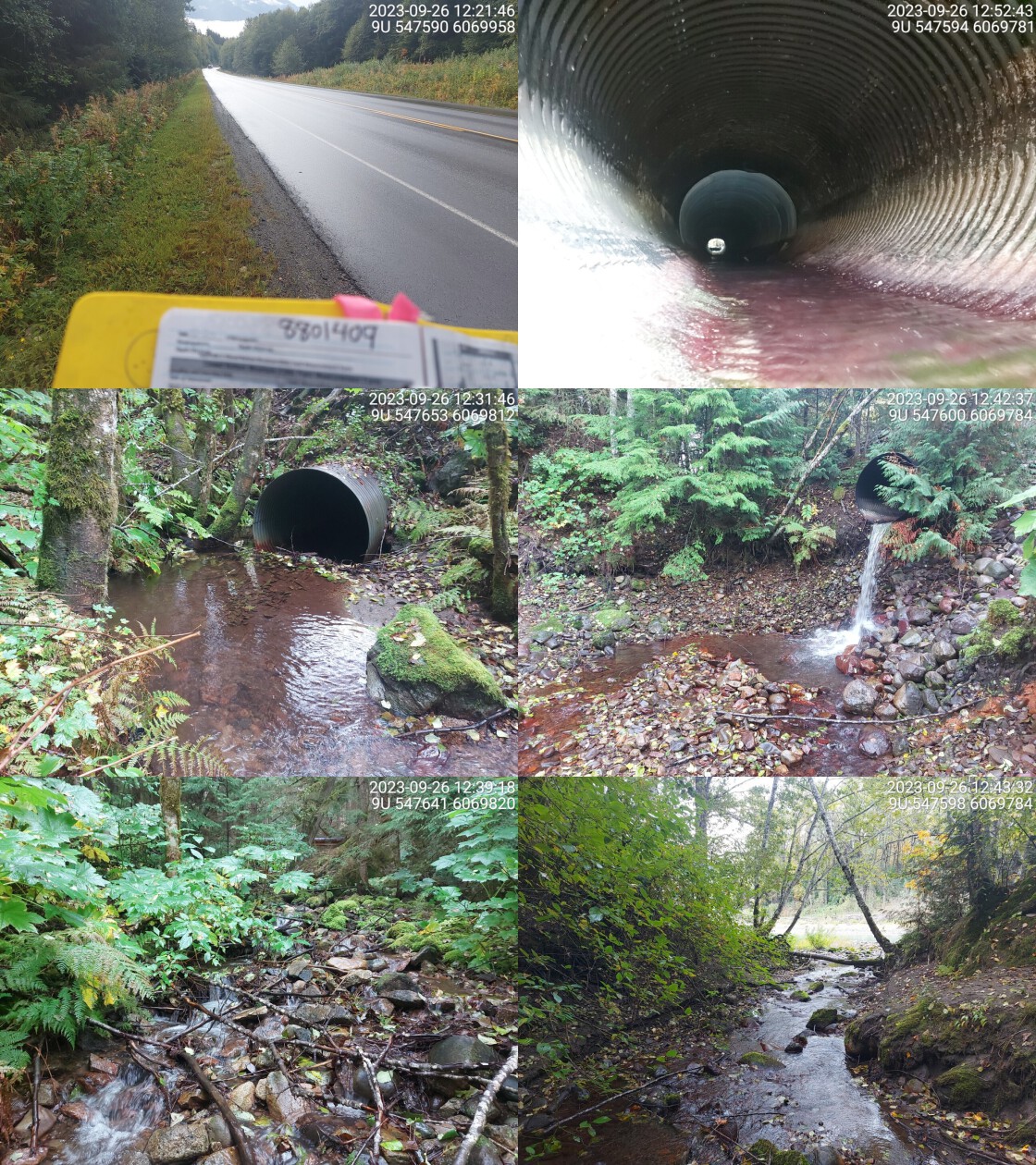
|
|||
| Comments: Massive outlet pool. Drains into skeena river side channel. High flow and steep gradient upstream. Only passable upstream to adult salmon. Crossing a definite barrier to all fish. Ministry of Transportation chris_culvert_id: 1923203. 12:48:25 |
| Location and Stream Data |
|
Crossing Characteristics | – |
|---|---|---|---|
| Date | 2023-09-26 | Crossing Sub Type | Ford |
| PSCIS ID | 198933 | Diameter (m) | – |
| External ID | 8801991 | Length (m) | – |
| Crew | AI | Embedded | – |
| UTM Zone | 9 | Depth Embedded (m) | – |
| Easting | 536546 | Resemble Channel | – |
| Northing | 6046289 | Backwatered | – |
| Stream | Fall Creek | Percent Backwatered | – |
| Road | Spur | Fill Depth (m) | – |
| Road Tenure | Coast Tsimshian Resources Limited Partnership | Outlet Drop (m) | – |
| Channel Width (m) | – | Outlet Pool Depth (m) | – |
| Stream Slope (%) | – | Inlet Drop | – |
| Beaver Activity | No | Slope (%) | – |
| Habitat Value | – | Valley Fill | – |
| Final score | 0 | Barrier Result | Unknown |
| Fix type | – | Fix Span / Diameter | – |
Photos: PSCIS ID 198933. From top left clockwise: Road/Site Card, Barrel, Outlet, Downstream, Upstream, Inlet.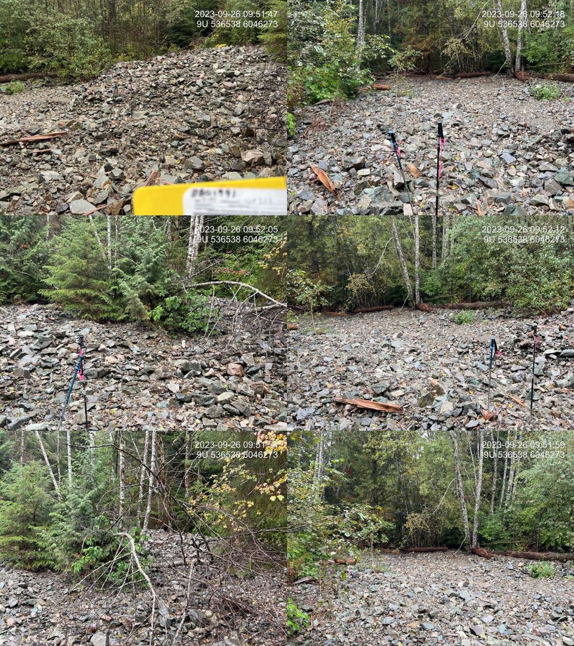
|
|||
| Comments: Stream is completely blown out at this location due to a major debris event. All water is sub surface.. 09:52:40 |
| Location and Stream Data |
|
Crossing Characteristics | – |
|---|---|---|---|
| Date | 2023-09-12 | Crossing Sub Type | Round Culvert |
| PSCIS ID | 198934 | Diameter (m) | 1.6 |
| External ID | 14000571 | Length (m) | 18 |
| Crew | MW | Embedded | No |
| UTM Zone | 9 | Depth Embedded (m) | – |
| Easting | 631703 | Resemble Channel | No |
| Northing | 6017418 | Backwatered | No |
| Stream | Tributary to Houston Tommy Creek | Percent Backwatered | – |
| Road | Spur | Fill Depth (m) | 8 |
| Road Tenure | Canfor R07549 | Outlet Drop (m) | 0.7 |
| Channel Width (m) | 2.8 | Outlet Pool Depth (m) | 0.5 |
| Stream Slope (%) | 3 | Inlet Drop | No |
| Beaver Activity | No | Slope (%) | 4 |
| Habitat Value | High | Valley Fill | Deep Fill |
| Final score | 39 | Barrier Result | Barrier |
| Fix type | Replace Structure with Streambed Simulation CBS | Fix Span / Diameter | 4.5 |
Photos: PSCIS ID 198934. From top left clockwise: Road/Site Card, Barrel, Outlet, Downstream, Upstream, Inlet.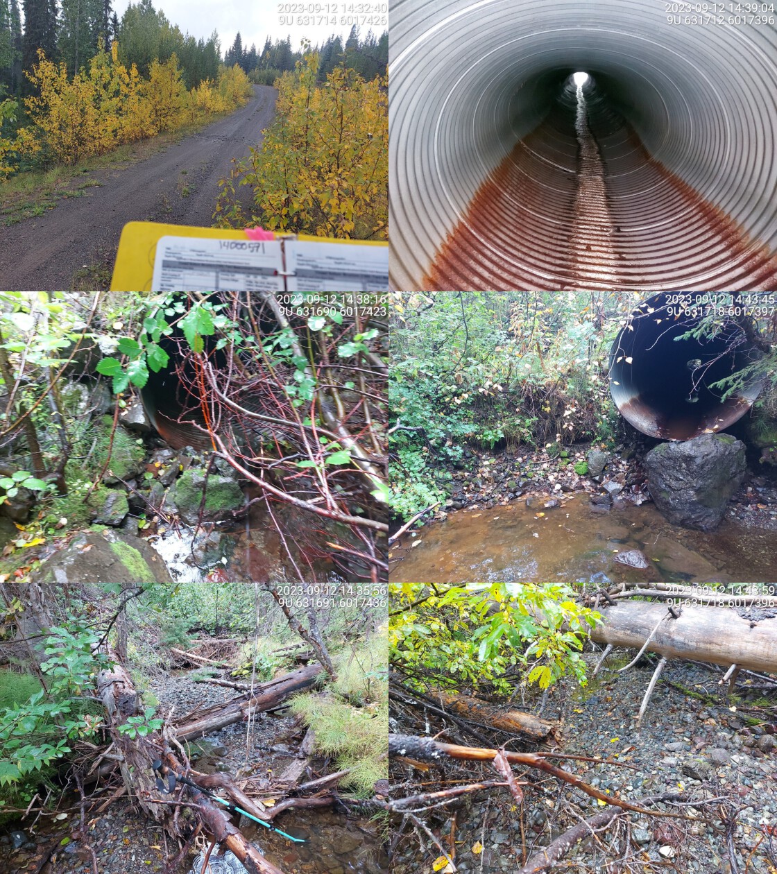
|
|||
| Comments: Very good habitat upstream and downstream. Culvert is a little bent in the middle. Big outlet drop, fish spotted in outlet pool. Moderate flowing stream.. 14:35:45 |
| Location and Stream Data |
|
Crossing Characteristics | – |
|---|---|---|---|
| Date | 2023-09-12 | Crossing Sub Type | Round Culvert |
| PSCIS ID | 198935 | Diameter (m) | 1.2 |
| External ID | 14000575 | Length (m) | 16 |
| Crew | MW | Embedded | No |
| UTM Zone | 9 | Depth Embedded (m) | – |
| Easting | 636436 | Resemble Channel | No |
| Northing | 6020756 | Backwatered | No |
| Stream | Tributary to Knapper Creek | Percent Backwatered | – |
| Road | Gold Creek FSR | Fill Depth (m) | 1.5 |
| Road Tenure | Canfor R07549 | Outlet Drop (m) | 0.2 |
| Channel Width (m) | 2.2 | Outlet Pool Depth (m) | 0.9 |
| Stream Slope (%) | 2.5 | Inlet Drop | No |
| Beaver Activity | No | Slope (%) | 0 |
| Habitat Value | High | Valley Fill | Deep Fill |
| Final score | 24 | Barrier Result | Barrier |
| Fix type | Replace with New Open Bottom Structure | Fix Span / Diameter | 15 |
Photos: PSCIS ID 198935. From top left clockwise: Road/Site Card, Barrel, Outlet, Downstream, Upstream, Inlet.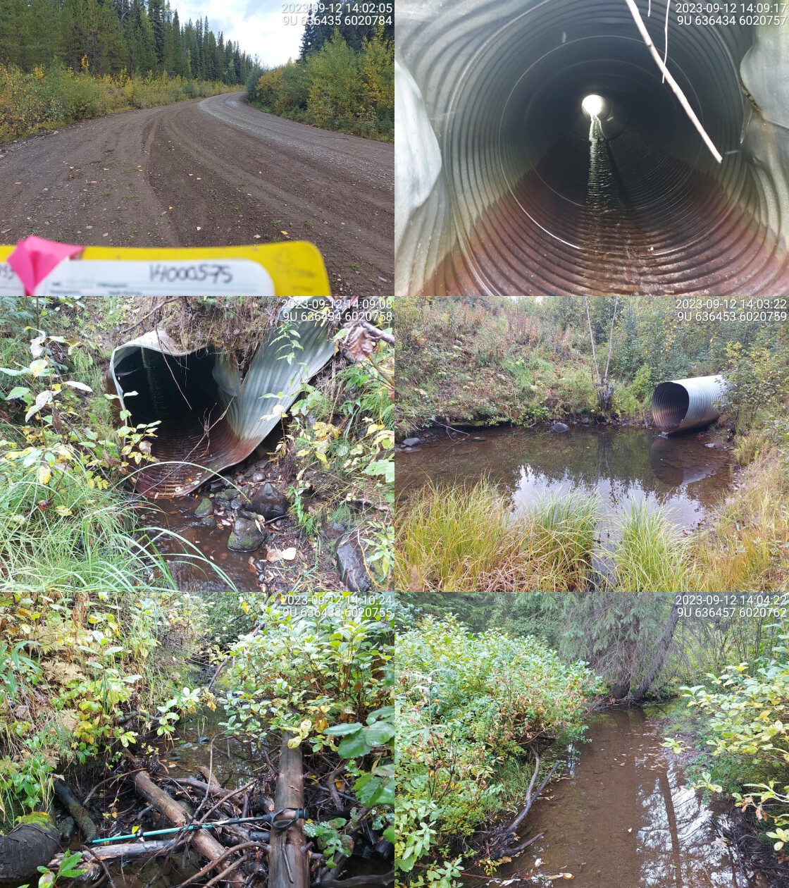
|
|||
| Comments: Culvert very warped on inlet side. Deep outlet pool indicating culvert is undersized. Fry spotted in outlet pool. Wide channel with good flow and habitat value. Cutthroat trout confirmed upstream.. 14:12:45 |
| Location and Stream Data |
|
Crossing Characteristics | – |
|---|---|---|---|
| Date | 2023-09-16 | Crossing Sub Type | Round Culvert |
| PSCIS ID | 198936 | Diameter (m) | 0.9 |
| External ID | 14000637 | Length (m) | 24 |
| Crew | AI | Embedded | No |
| UTM Zone | 9 | Depth Embedded (m) | – |
| Easting | 640014 | Resemble Channel | No |
| Northing | 6023911 | Backwatered | No |
| Stream | Tributary to Morice River | Percent Backwatered | – |
| Road | Gold Creek FSR | Fill Depth (m) | 5 |
| Road Tenure | Canfor R07549 | Outlet Drop (m) | 0.75 |
| Channel Width (m) | 2 | Outlet Pool Depth (m) | 0.15 |
| Stream Slope (%) | 1.5 | Inlet Drop | No |
| Beaver Activity | No | Slope (%) | 2 |
| Habitat Value | Medium | Valley Fill | Deep Fill |
| Final score | 34 | Barrier Result | Barrier |
| Fix type | Replace with New Open Bottom Structure | Fix Span / Diameter | 21 |
Photos: PSCIS ID 198936. From top left clockwise: Road/Site Card, Barrel, Outlet, Downstream, Upstream, Inlet.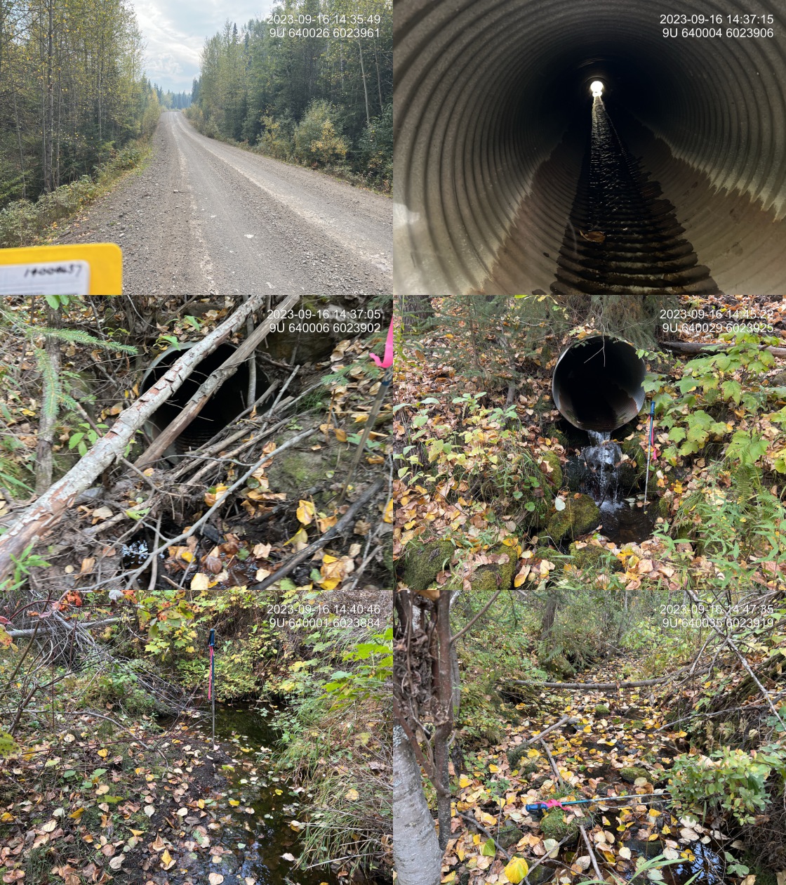
|
|||
| Comments: Really good flow for the area on this very dry year. Numerous small fish observed upstream of the culvert. Cattle accessing the stream from the road upstream. Large outlet drop.. 14:42:55 |
| Location and Stream Data |
|
Crossing Characteristics | – |
|---|---|---|---|
| Date | 2023-09-12 | Crossing Sub Type | Round Culvert |
| PSCIS ID | 198937 | Diameter (m) | 1.2 |
| External ID | 14000638 | Length (m) | 24 |
| Crew | MW | Embedded | No |
| UTM Zone | 9 | Depth Embedded (m) | – |
| Easting | 637531 | Resemble Channel | No |
| Northing | 6021808 | Backwatered | No |
| Stream | Tributary to Morice River | Percent Backwatered | – |
| Road | Gold Creek FSR | Fill Depth (m) | 4 |
| Road Tenure | Canfor R07549 | Outlet Drop (m) | 0 |
| Channel Width (m) | 1.7 | Outlet Pool Depth (m) | 0.4 |
| Stream Slope (%) | 4 | Inlet Drop | No |
| Beaver Activity | No | Slope (%) | 5 |
| Habitat Value | Medium | Valley Fill | Deep Fill |
| Final score | 29 | Barrier Result | Barrier |
| Fix type | Replace Structure with Streambed Simulation CBS | Fix Span / Diameter | 3 |
Photos: PSCIS ID 198937. From top left clockwise: Road/Site Card, Barrel, Outlet, Downstream, Upstream, Inlet.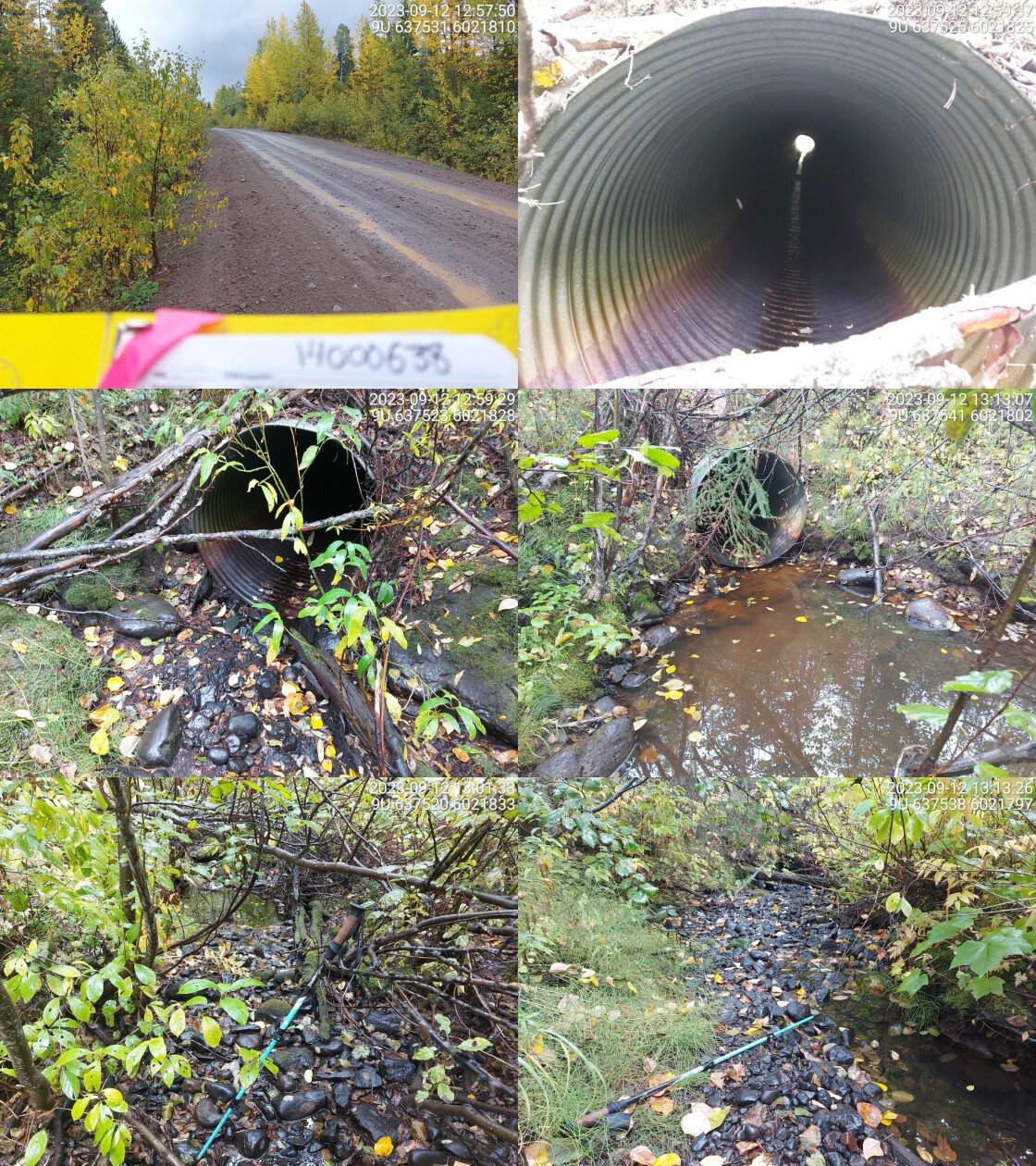
|
|||
| Comments: Stream is mostly dewatered, not flowing. Some water in pools. Small amount of water in culvert but no flow.ing water. Outlet pool present. Habitat looks good at higher flows.. 13:11:07 |
| Location and Stream Data |
|
Crossing Characteristics | – |
|---|---|---|---|
| Date | 2023-09-13 | Crossing Sub Type | Round Culvert |
| PSCIS ID | 198938 | Diameter (m) | 0.75 |
| External ID | 14000707 | Length (m) | 26 |
| Crew | AI | Embedded | No |
| UTM Zone | 9 | Depth Embedded (m) | – |
| Easting | 648055 | Resemble Channel | No |
| Northing | 5994865 | Backwatered | No |
| Stream | Wrinch Creek | Percent Backwatered | – |
| Road | Morice-Owen FSR | Fill Depth (m) | 1.5 |
| Road Tenure | YLP Woodlands GP Ltd. | Outlet Drop (m) | 0.3 |
| Channel Width (m) | 1.5 | Outlet Pool Depth (m) | 0.75 |
| Stream Slope (%) | 2 | Inlet Drop | No |
| Beaver Activity | No | Slope (%) | 2 |
| Habitat Value | Medium | Valley Fill | Deep Fill |
| Final score | 34 | Barrier Result | Barrier |
| Fix type | Replace Structure with Streambed Simulation CBS | Fix Span / Diameter | 3 |
Photos: PSCIS ID 198938. From top left clockwise: Road/Site Card, Barrel, Outlet, Downstream, Upstream, Inlet.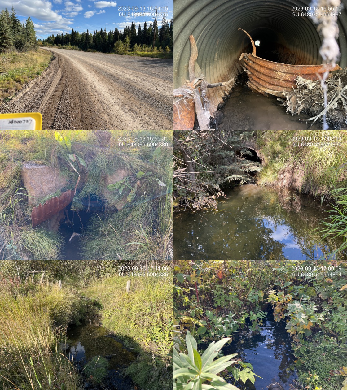
|
|||
| Comments: Good flow for area and this time of year. Small channel through wetland type area downstream. Inlet of pipe is damaged with part of the pipe lodged inside. Substrate upstream appears to be composed of fines only.. 17:07:05 |
| Location and Stream Data |
|
Crossing Characteristics | – |
|---|---|---|---|
| Date | 2023-09-13 | Crossing Sub Type | Round Culvert |
| PSCIS ID | 198939 | Diameter (m) | 1.3 |
| External ID | 14000708 | Length (m) | 15 |
| Crew | MW | Embedded | Yes |
| UTM Zone | 9 | Depth Embedded (m) | 0.1 |
| Easting | 647362 | Resemble Channel | Yes |
| Northing | 5997427 | Backwatered | No |
| Stream | Emil Creek | Percent Backwatered | – |
| Road | Morice-Owen FSR | Fill Depth (m) | 1 |
| Road Tenure | YLP Woodlands GP Ltd. | Outlet Drop (m) | 0 |
| Channel Width (m) | 2.5 | Outlet Pool Depth (m) | 0 |
| Stream Slope (%) | 4 | Inlet Drop | No |
| Beaver Activity | No | Slope (%) | 2 |
| Habitat Value | High | Valley Fill | Deep Fill |
| Final score | 19 | Barrier Result | Potential |
| Fix type | Replace with New Open Bottom Structure | Fix Span / Diameter | 15 |
Photos: PSCIS ID 198939. From top left clockwise: Road/Site Card, Barrel, Outlet, Downstream, Upstream, Inlet.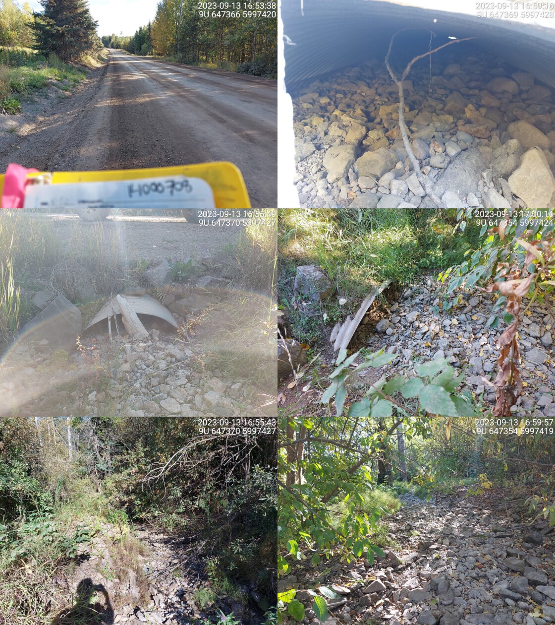
|
|||
| Comments: Stream is dewatered. Wide channel with embedded culvert. Culvert is filled with substrate almost all the way to the top. Looks like high habitat quality when stream is flowing. Culvert is close to road, with a lower fill depth on inlet side.. 16:55:20 |
| Location and Stream Data |
|
Crossing Characteristics | – |
|---|---|---|---|
| Date | 2023-09-12 | Crossing Sub Type | Round Culvert |
| PSCIS ID | 198940 | Diameter (m) | 0.9 |
| External ID | 14000855 | Length (m) | 18 |
| Crew | MW | Embedded | No |
| UTM Zone | 9 | Depth Embedded (m) | – |
| Easting | 636691 | Resemble Channel | No |
| Northing | 6020943 | Backwatered | No |
| Stream | Tributary to Knapper Creek | Percent Backwatered | – |
| Road | Knapper Rd | Fill Depth (m) | 1 |
| Road Tenure | Canfor R07549 | Outlet Drop (m) | 0 |
| Channel Width (m) | 1.9 | Outlet Pool Depth (m) | 1.2 |
| Stream Slope (%) | 3 | Inlet Drop | No |
| Beaver Activity | Yes | Slope (%) | 1 |
| Habitat Value | High | Valley Fill | Deep Fill |
| Final score | 24 | Barrier Result | Barrier |
| Fix type | Replace Structure with Streambed Simulation CBS | Fix Span / Diameter | 3 |
Photos: PSCIS ID 198940. From top left clockwise: Road/Site Card, Barrel, Outlet, Downstream, Upstream, Inlet.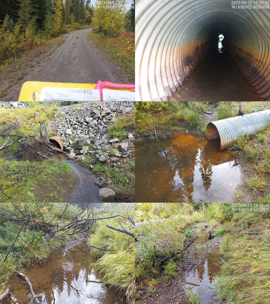
|
|||
| Comments: Erosion present on road near outlet. Old rusted culvert. Fry spotted near inlet. Debris jam blocking most of inlet. Good habitat on both sides. Not a very high traffic road. Might need restoration if road erodes further. Culvert is a little undersized. Confirmed fish presence upstream of culvert. This crossing and upstream crossing would be good candidates for replacement.. 13:44:21 |
| Location and Stream Data |
|
Crossing Characteristics | – |
|---|---|---|---|
| Date | 2023-09-16 | Crossing Sub Type | Round Culvert |
| PSCIS ID | 198941 | Diameter (m) | 1 |
| External ID | 14001105 | Length (m) | 10 |
| Crew | MW | Embedded | No |
| UTM Zone | 9 | Depth Embedded (m) | – |
| Easting | 631178 | Resemble Channel | No |
| Northing | 6018352 | Backwatered | No |
| Stream | Tributary to Houston Tommy Creek | Percent Backwatered | – |
| Road | Holland Rd | Fill Depth (m) | 0.6 |
| Road Tenure | Canfor R07549 | Outlet Drop (m) | 0.2 |
| Channel Width (m) | 0.8 | Outlet Pool Depth (m) | 0 |
| Stream Slope (%) | 2.5 | Inlet Drop | No |
| Beaver Activity | No | Slope (%) | 1 |
| Habitat Value | Low | Valley Fill | Deep Fill |
| Final score | 20 | Barrier Result | Barrier |
| Fix type | Replace Structure with Streambed Simulation CBS | Fix Span / Diameter | 3 |
Photos: PSCIS ID 198941. From top left clockwise: Road/Site Card, Barrel, Outlet, Downstream, Upstream, Inlet.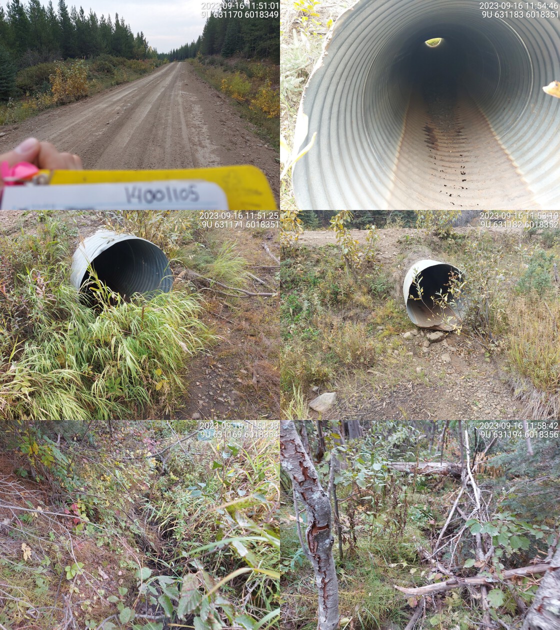
|
|||
| Comments: Dewatered tributary. Very overgrown and small stream channel. Culvert is bent downwards near the middle.. 11:48:23 |
| Location and Stream Data |
|
Crossing Characteristics | – |
|---|---|---|---|
| Date | 2023-09-12 | Crossing Sub Type | Round Culvert |
| PSCIS ID | 198942 | Diameter (m) | 1.2 |
| External ID | 14001106 | Length (m) | 14 |
| Crew | MW | Embedded | No |
| UTM Zone | 9 | Depth Embedded (m) | – |
| Easting | 631508 | Resemble Channel | No |
| Northing | 6018096 | Backwatered | No |
| Stream | Tributary to Houston Tommy Creek | Percent Backwatered | – |
| Road | Holland Rd | Fill Depth (m) | 0.7 |
| Road Tenure | Canfor R07549 | Outlet Drop (m) | 0.1 |
| Channel Width (m) | 1.9 | Outlet Pool Depth (m) | 0.7 |
| Stream Slope (%) | 2 | Inlet Drop | No |
| Beaver Activity | No | Slope (%) | 1 |
| Habitat Value | High | Valley Fill | Deep Fill |
| Final score | 21 | Barrier Result | Barrier |
| Fix type | Replace Structure with Streambed Simulation CBS | Fix Span / Diameter | 3 |
Photos: PSCIS ID 198942. From top left clockwise: Road/Site Card, Barrel, Outlet, Downstream, Upstream, Inlet.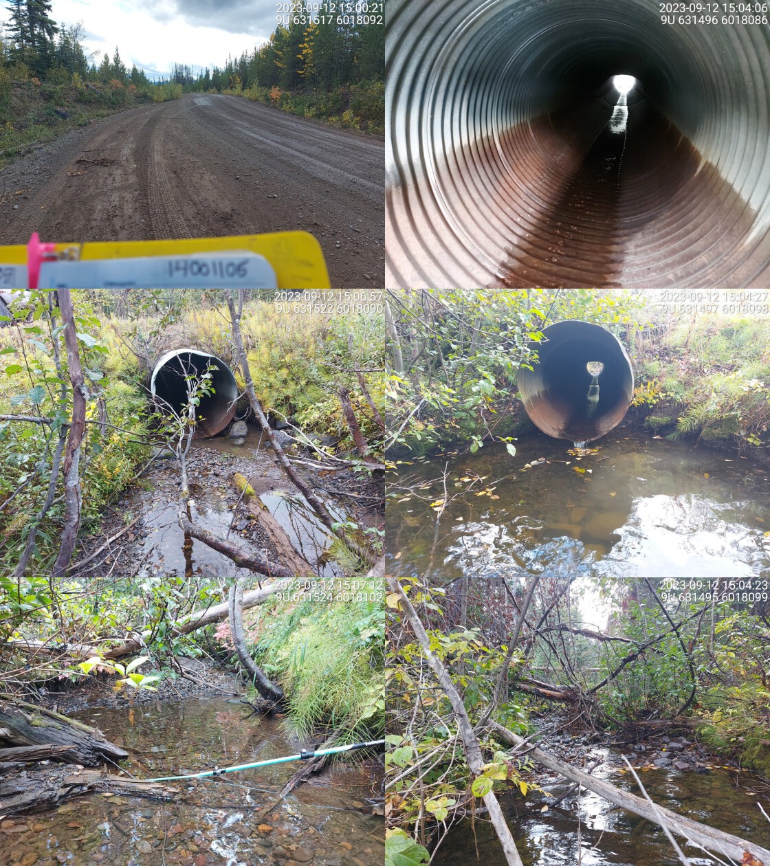
|
|||
| Comments: Deep outlet pool, culvert may be undersized. Relatively wide stream with good habitat, dolly varden confirmed downstream in the past.. 15:05:09 |
| Location and Stream Data |
|
Crossing Characteristics | – |
|---|---|---|---|
| Date | 2023-09-18 | Crossing Sub Type | Ford |
| PSCIS ID | 198943 | Diameter (m) | – |
| External ID | 24600461 | Length (m) | – |
| Crew | AI | Embedded | – |
| UTM Zone | 9 | Depth Embedded (m) | – |
| Easting | 590954 | Resemble Channel | – |
| Northing | 6071963 | Backwatered | – |
| Stream | Tributary to McDonell Lake | Percent Backwatered | – |
| Road | Spur | Fill Depth (m) | – |
| Road Tenure | Unclassified | Outlet Drop (m) | – |
| Channel Width (m) | – | Outlet Pool Depth (m) | – |
| Stream Slope (%) | – | Inlet Drop | – |
| Beaver Activity | No | Slope (%) | – |
| Habitat Value | – | Valley Fill | – |
| Final score | 0 | Barrier Result | Unknown |
| Fix type | – | Fix Span / Diameter | – |
Photos: PSCIS ID 198943. From top left clockwise: Road/Site Card, Barrel, Outlet, Downstream, Upstream, Inlet.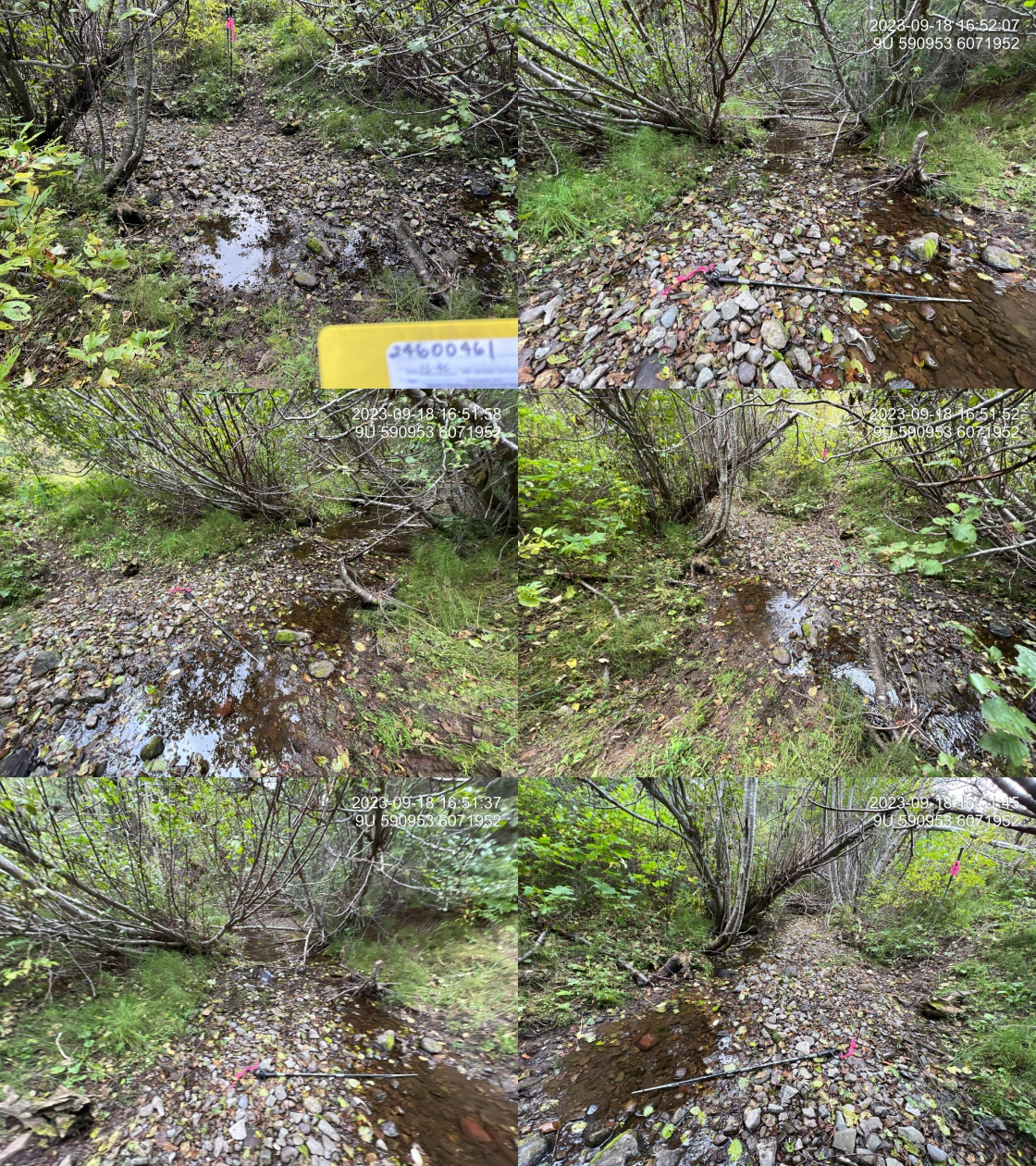
|
|||
| Comments: Area of historic sockeye spawning just upstream. Fry observed in stream. Abundant gravel throughout.. 16:49:33 |
| Location and Stream Data |
|
Crossing Characteristics | – |
|---|---|---|---|
| Date | 2023-09-19 | Crossing Sub Type | Round Culvert |
| PSCIS ID | 198944 | Diameter (m) | 0.6 |
| External ID | 24601268 | Length (m) | 12 |
| Crew | MW | Embedded | No |
| UTM Zone | 9 | Depth Embedded (m) | – |
| Easting | 597568 | Resemble Channel | No |
| Northing | 6070337 | Backwatered | No |
| Stream | Tributary to Zymoetz River | Percent Backwatered | – |
| Road | Dennis West FSR | Fill Depth (m) | 0.8 |
| Road Tenure | Wetzinkwa Community Forest Corporation | Outlet Drop (m) | 1 |
| Channel Width (m) | 1.1 | Outlet Pool Depth (m) | 0.3 |
| Stream Slope (%) | 8 | Inlet Drop | No |
| Beaver Activity | No | Slope (%) | 6 |
| Habitat Value | Low | Valley Fill | Deep Fill |
| Final score | 36 | Barrier Result | Barrier |
| Fix type | Replace Structure with Streambed Simulation CBS | Fix Span / Diameter | 3 |
Photos: PSCIS ID 198944. From top left clockwise: Road/Site Card, Barrel, Outlet, Downstream, Upstream, Inlet.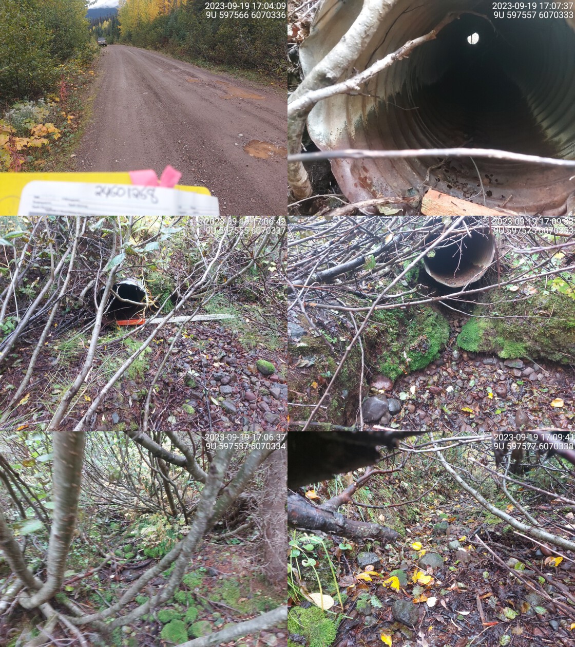
|
|||
| Comments: Dewatered stream, small channel and overgrown. Very big outlet drop. Historic Fiss obstacle (cascade/chute) just downstream.. 17:02:08 |
| Location and Stream Data |
|
Crossing Characteristics | – |
|---|---|---|---|
| Date | 2023-09-19 | Crossing Sub Type | Wood Box Culvert |
| PSCIS ID | 198945 | Diameter (m) | 5 |
| External ID | 24601275 | Length (m) | 20 |
| Crew | AI | Embedded | – |
| UTM Zone | 9 | Depth Embedded (m) | – |
| Easting | 592861 | Resemble Channel | – |
| Northing | 6070871 | Backwatered | – |
| Stream | Tributary to McDonell Lake | Percent Backwatered | – |
| Road | Denis West FSR | Fill Depth (m) | – |
| Road Tenure | BCTS R22433 | Outlet Drop (m) | – |
| Channel Width (m) | – | Outlet Pool Depth (m) | – |
| Stream Slope (%) | – | Inlet Drop | – |
| Beaver Activity | No | Slope (%) | – |
| Habitat Value | – | Valley Fill | – |
| Final score | 3 | Barrier Result | Passable |
| Fix type | – | Fix Span / Diameter | – |
Photos: PSCIS ID 198945. From top left clockwise: Road/Site Card, Barrel, Outlet, Downstream, Upstream, Inlet.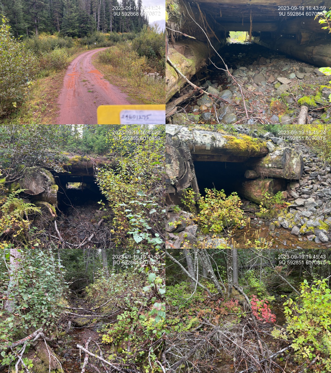
|
|||
| Comments: Wood box culvert with huge timbers.. 16:47:42 |
| Location and Stream Data |
|
Crossing Characteristics | – |
|---|---|---|---|
| Date | 2023-09-19 | Crossing Sub Type | Round Culvert |
| PSCIS ID | 198946 | Diameter (m) | 1.1 |
| External ID | 24601279 | Length (m) | 10 |
| Crew | MW | Embedded | No |
| UTM Zone | 9 | Depth Embedded (m) | – |
| Easting | 590211 | Resemble Channel | No |
| Northing | 6069931 | Backwatered | No |
| Stream | Tributary to McDonell Lake | Percent Backwatered | – |
| Road | Dennis West FSR | Fill Depth (m) | 1.2 |
| Road Tenure | BCTS R22433 | Outlet Drop (m) | 0 |
| Channel Width (m) | 0.8 | Outlet Pool Depth (m) | 0 |
| Stream Slope (%) | 11 | Inlet Drop | No |
| Beaver Activity | No | Slope (%) | 8 |
| Habitat Value | Low | Valley Fill | Deep Fill |
| Final score | 20 | Barrier Result | Barrier |
| Fix type | Replace Structure with Streambed Simulation CBS | Fix Span / Diameter | 3 |
Photos: PSCIS ID 198946. From top left clockwise: Road/Site Card, Barrel, Outlet, Downstream, Upstream, Inlet.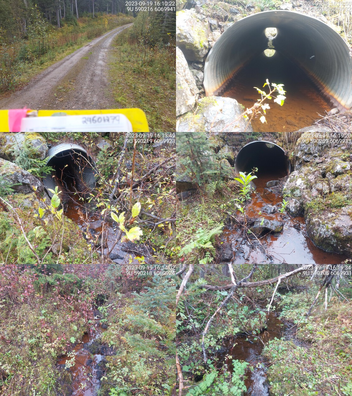
|
|||
| Comments: Grassy wetland habitat upstream and small channel. Steep system. Stream bed substrate is mostly mud. 16:12:26 |
| Location and Stream Data |
|
Crossing Characteristics | – |
|---|---|---|---|
| Date | 2023-09-19 | Crossing Sub Type | Round Culvert |
| PSCIS ID | 198947 | Diameter (m) | 0.6 |
| External ID | 24601280 | Length (m) | 18 |
| Crew | AI | Embedded | No |
| UTM Zone | 9 | Depth Embedded (m) | – |
| Easting | 597637 | Resemble Channel | No |
| Northing | 6070211 | Backwatered | No |
| Stream | Tributary to Zymoetz River | Percent Backwatered | – |
| Road | Dennis West FSR | Fill Depth (m) | 1 |
| Road Tenure | Wetzinkwa Community Forest Corporation | Outlet Drop (m) | 0.18 |
| Channel Width (m) | 1.8 | Outlet Pool Depth (m) | 0.4 |
| Stream Slope (%) | 7 | Inlet Drop | Yes |
| Beaver Activity | No | Slope (%) | 5 |
| Habitat Value | Medium | Valley Fill | Deep Fill |
| Final score | 34 | Barrier Result | Barrier |
| Fix type | Replace Structure with Streambed Simulation CBS | Fix Span / Diameter | 3 |
Photos: PSCIS ID 198947. From top left clockwise: Road/Site Card, Barrel, Outlet, Downstream, Upstream, Inlet.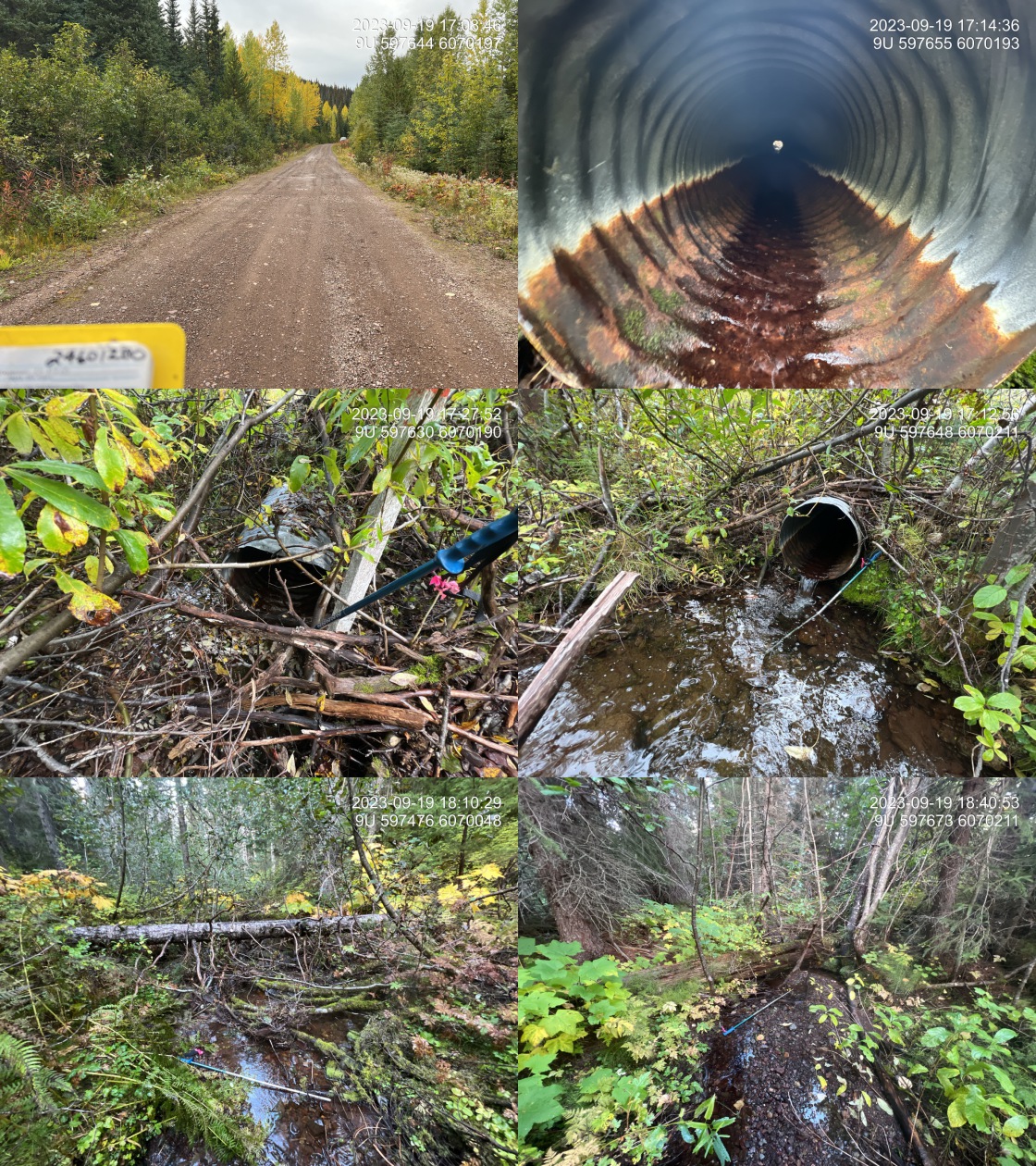
|
|||
| Comments: Nice stream with good flow and abundant gravel. Pipe is very under sized and appears to have been dredged at the upstream end to clear it. Fish observed in outlet pool.. 18:36:33 |
| Location and Stream Data |
|
Crossing Characteristics | – |
|---|---|---|---|
| Date | 2023-09-27 | Crossing Sub Type | Round Culvert |
| PSCIS ID | 198948 | Diameter (m) | 1 |
| External ID | 2023092701 | Length (m) | 14 |
| Crew | MW | Embedded | No |
| UTM Zone | 9 | Depth Embedded (m) | – |
| Easting | 614784 | Resemble Channel | No |
| Northing | 6010128 | Backwatered | No |
| Stream | Tributary to Tagit Creek | Percent Backwatered | – |
| Road | 9946-27 Rd | Fill Depth (m) | 1 |
| Road Tenure | West Fraser Mills Ltd. | Outlet Drop (m) | 0.3 |
| Channel Width (m) | 1.2 | Outlet Pool Depth (m) | 0.8 |
| Stream Slope (%) | 3 | Inlet Drop | Yes |
| Beaver Activity | Yes | Slope (%) | 2 |
| Habitat Value | Low | Valley Fill | Deep Fill |
| Final score | 28 | Barrier Result | Barrier |
| Fix type | Replace Structure with Streambed Simulation CBS | Fix Span / Diameter | 3 |
Photos: PSCIS ID 198948. From top left clockwise: Road/Site Card, Barrel, Outlet, Downstream, Upstream, Inlet.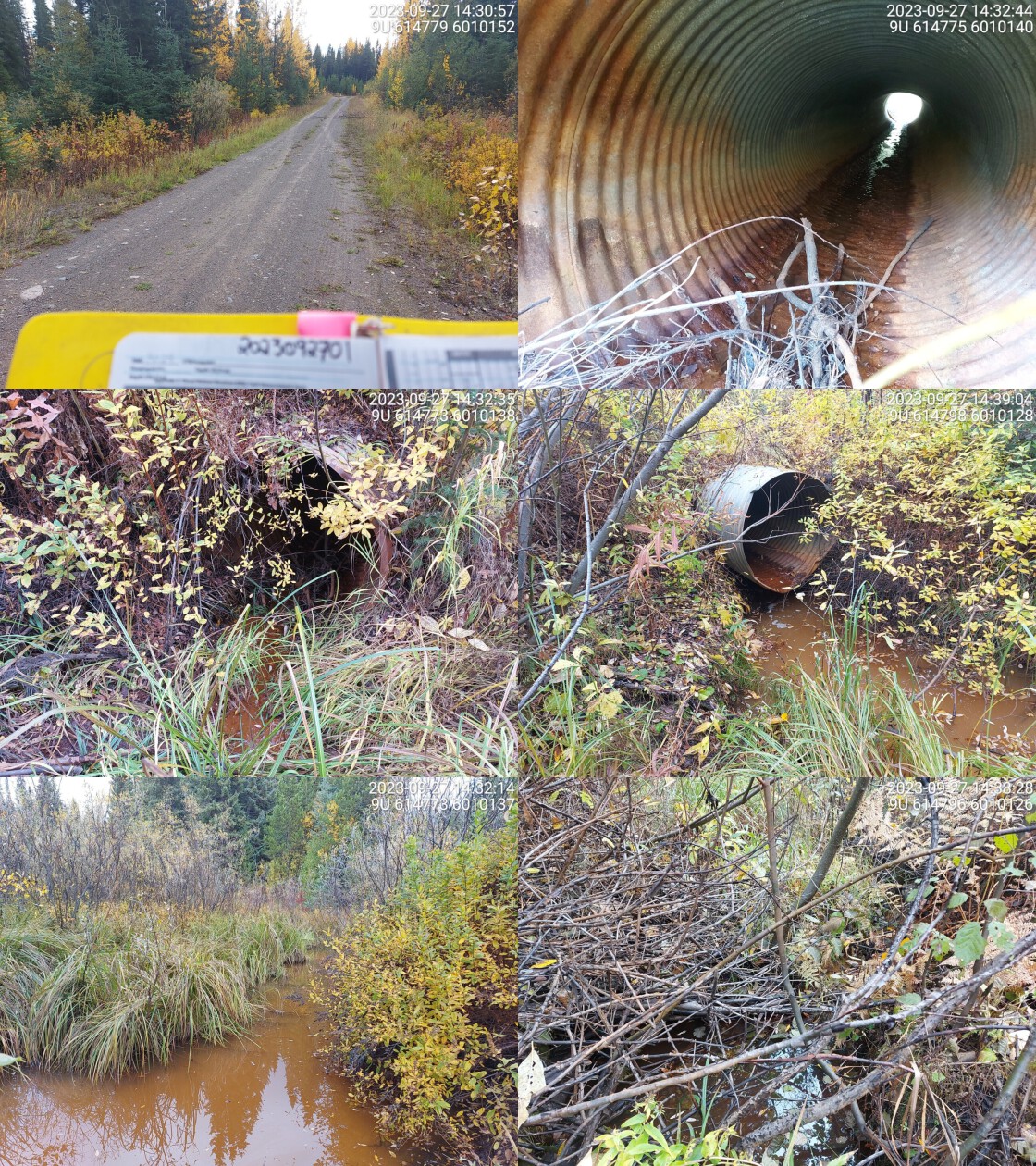
|
|||
| Comments: Wetland habitat upstream and immediately downstream. Defined stream channel approx 10m downstream of crossing. Small channel with low flow. Old culvert, deep outlet pool. Beaver dam at inlet creating small drop.. 14:40:33 |