Tributary to McDonell Lake - 8478 - Appendix
Site Location
PSCIS crossing 8478 is a located on a Tributary to McDonell Lake within the Zymoetz River watershed. The culvert is located on the Dennis West FSR at a point 1.9km upstream of where the stream flows north-west into the western end of McDonell Lake. The Forest Tenure Layer indicates that BC Timber Sales is responsible for the road at the crossing location.
Background
At crossing 8478, Tributary to McDonell Lake is a second order stream with an upstream watershed area of approximately 2.8km2. This stream drains a steep cold water system, where the elevation ranges from a maximum of 1710m to 940m near the crossing (Table 5.15).
The crossing was previously assessed with a fish passage assessment by Viveiros (2011) in 2010, with fish sampling and replacement with a streambed simulation recommneded. Approximately 1.5km downstream of crossing 8478 there is a documented sockeye spawning location in the FISS database, and upstream of the FSR dolly varden have been documented in the past (Norris [2018] 2024; MoE 2024b). Revisited in 2023, surveyors conducted a habitat confirmation assessment and electrofishing with results included in this memo.
fpr::fpr_table_wshd_sum(site_id = my_site) %>%
  fpr::fpr_kable(caption_text = paste0('Summary of derived upstream watershed statistics for PSCIS crossing ', my_site, '.'),
           footnote_text = 'Elev P60 = Elevation at which 60% of the watershed area is above',
scroll = F)| Site | Area Km | Elev Site | Elev Max | Elev Median | Elev P60 | Aspect |
|---|---|---|---|---|---|---|
| 8478 | 2.8 | 940 | 1710 | 1269 | 1233 | WSW |
| * Elev P60 = Elevation at which 60% of the watershed area is above |
Habitat modelling outputs form bcfishpass indicated only 400m of habitat accessible to steelhead or coho (stream gradients <20% and 15%) and no habitat of high intrinsic potential for either species (gradients <8.5% for steelhead and <5.5% for coho). Outputs are presented in Table
5.16. A map of the watershed is provided in
map attachment
093L.117.
| Habitat | Potential | Remediation Gain | Remediation Gain (%) |
|---|---|---|---|
| ST Network (km) | 0.4 | 0.4 | 100 |
| ST Lake Reservoir (ha) | 0.0 | 0.0 | – |
| ST Wetland (ha) | 0.0 | 0.0 | – |
| ST Slopeclass03 Waterbodies (km) | 0.0 | 0.0 | – |
| ST Slopeclass03 (km) | 0.0 | 0.0 | – |
| ST Slopeclass05 (km) | 0.0 | 0.0 | – |
| ST Slopeclass08 (km) | 0.0 | 0.0 | – |
| ST Spawning (km) | 0.0 | 0.0 | – |
| ST Rearing (km) | 0.0 | 0.0 | – |
| CH Spawning (km) | 0.0 | 0.0 | – |
| CH Rearing (km) | 0.0 | 0.0 | – |
| CO Spawning (km) | 0.0 | 0.0 | – |
| CO Rearing (km) | 0.0 | 0.0 | – |
| CO Rearing (ha) | 0.0 | 0.0 | – |
| SK Spawning (km) | 0.0 | 0.0 | – |
| SK Rearing (km) | 0.0 | 0.0 | – |
| SK Rearing (ha) | 0.0 | 0.0 | – |
| * Model data is preliminary and subject to adjustments. |
Stream Characteristics at Crossing 8478
At the time of the survey in 2023, PSCIS crossing 8478 was un-embedded, non-backwatered and ranked as a barrier to upstream fish passage according to the provincial protocol (MoE 2011) (Table 5.17). The culvert was slightly undersized for the size of the stream with an outlet drop measured at 0.2m high. Water temperature was 5.6\(^\circ\)C, pH was 7.4 and conductivity was 153uS/cm.
| Location and Stream Data |
|
Crossing Characteristics | – |
|---|---|---|---|
| Date | 2023-09-19 | Crossing Sub Type | Round Culvert |
| PSCIS ID | 8478 | Diameter (m) | 1.9 |
| External ID | – | Length (m) | 12 |
| Crew | AI | Embedded | No |
| UTM Zone | 9 | Depth Embedded (m) | – |
| Easting | 590065 | Resemble Channel | No |
| Northing | 6069867 | Backwatered | No |
| Stream | Tributary to McDonell Lake | Percent Backwatered | – |
| Road | Dennis West FSR | Fill Depth (m) | 1.5 |
| Road Tenure | BCTS R22433 | Outlet Drop (m) | 0.2 |
| Channel Width (m) | 2.5 | Outlet Pool Depth (m) | 0.25 |
| Stream Slope (%) | 8 | Inlet Drop | Yes |
| Beaver Activity | No | Slope (%) | 4 |
| Habitat Value | Medium | Valley Fill | Deep Fill |
| Final score | 31 | Barrier Result | Barrier |
| Fix type | Replace with New Open Bottom Structure | Fix Span / Diameter | 15 |
Photos: From top left clockwise: Road/Site Card, Barrel, Outlet, Downstream, Upstream, Inlet.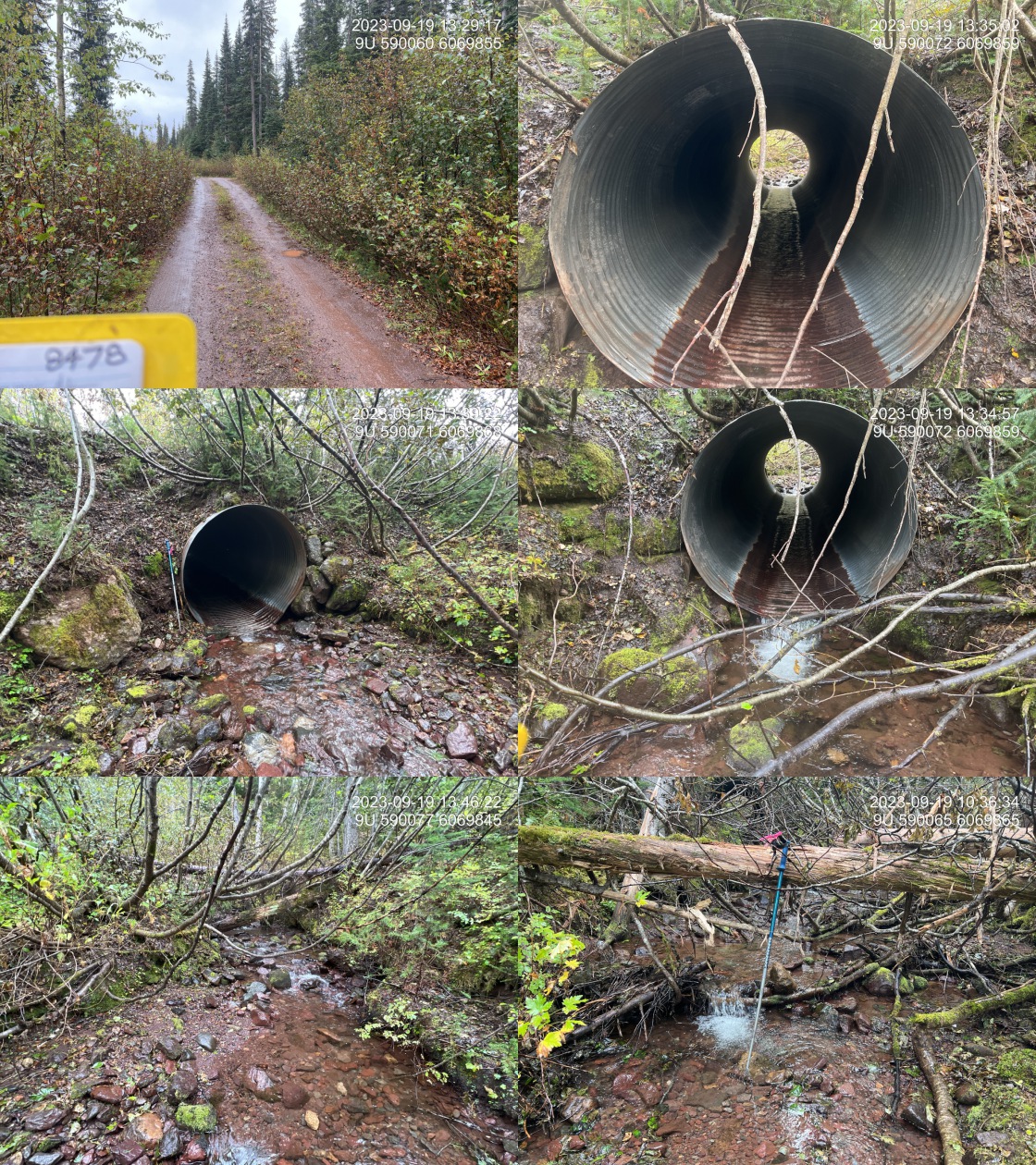
|
|||
| Comments: Pipe is in good condition. Nice habitat upstream and downstream. Very good flow for time of year. Dolly Varden captured upstream and downstream of crossing.. 13:30:02 |
Stream Characteristics Downstream
The stream was surveyed downstream from crossing 8478 for 200m . Total cover amount was rated as moderate with large woody debris dominant. Cover was also present as small woody debris, undercut banks, and overhanging vegetation.The average channel width was 3m, the average wetted width was 2.2m, and the average gradient was 8.3%.The dominant substrate was gravels with cobbles sub-dominant. The stream was noted as having good flow and containing pockets of gravel suitable for spawning (Figure 5.13). Deep pools were infrequent and the morphology was step-pool cobble. The habitat was rated as medium value suitable for salmonid rearing and spawning.
Stream Characteristics Upstream
The stream was surveyed upstream from crossing 8478 for 400m to a point where gradients increased to 20% (Figure 5.14). Total cover amount was rated as moderate with large woody debris dominant. Cover was also present as small woody debris and boulders.The dominant substrate was cobbles with gravels sub-dominant.The average channel width was 2.5m, the average wetted width was 1.8m, and the average gradient was 10%. There was good flow volume in the area surveyed and step-pool cascades (<1m high) created by large woody debris present throughout and pockets of gravel present suitable for spawning. The habitat was rated as medium value with moderate rearing potential for dolly varden.
Fish Sampling
Electrofishing was conducted at three sites below and one site above the FSR with results summarised in Tables 5.19 - 5.20 and Figure 5.12. A total of 12 dolly varden were captured downstream, and 5 dolly varden were captured upstream. Multiple fish captured had deteriorating purple gill plates and unusual round black spots (Figures 5.15 - 5.16). All fish captured with a fork length greater than 60mm were tagged with Passive Integrated Transponders (PIT tags) with data stored here.
Structure Remediation and Cost Estimate
Although replacement of PSCIS crossing 8478 with a streambed simulation may be feasible and a potentially more economical option, replacement with a bridge (15m span) is roughly estimated to cost $450,000. Deactivation of the Dennis West FSR beyond the culvert and removal of the crossing could also be explored as a cost-effective option.
Conclusion
PSCIS crossing 8478 is located on a steeper, colder water stream providing medium value habitat for dolly varden in the areas surveyed. Habitat modelling and ground measurements of gradient upstream of the Dennis West FSR were slightly above the selected threshold for high intrinsic potential for steelhead rearing (>8.5%) with averaged values at 10%. As these relatively steep gradients drain a relatively high elevation watershed it may be most suitable for dolly varden. The site was rated as a moderate priority for replacement containing medium value for salmonid rearing and spawning. As noted earlier, multiple fish captured had deteriorating purple gill plates and unusual round black spots potentially indicating some sort of natural or anthropogenic contaminants draining into the watershed.
tab_hab_summary %>%
  filter(Site  == my_site) %>%
  # select(-Site) %>%
  fpr::fpr_kable(caption_text = paste0('Summary of habitat details for PSCIS crossing ', my_site, '.'),
scroll = F) | Site | Location | Length Surveyed (m) | Channel Width (m) | Wetted Width (m) | Pool Depth (m) | Gradient (%) | Total Cover | Habitat Value |
|---|---|---|---|---|---|---|---|---|
| 8478 | Downstream | 200 | 3.0 | 2.2 | 0.3 | 8.3 | moderate | Medium |
| 8478 | Upstream | 400 | 2.5 | 1.8 | 0.5 | 10.0 | moderate | Medium |
| site | passes | ef_length_m | ef_width_m | area_m2 | enclosure |
|---|---|---|---|---|---|
| 8478_ds_ef1 | 1 | 24 | 2.22 | 53.3 | Open |
| 8478_ds_ef2 | 1 | 45 | 1.77 | 79.7 | Open |
| 8478_ds_ef3 | 1 | 25 | 1.83 | 45.8 | Open |
| 8478_us | 1 | 400 | 1.83 | 732.0 | Open |
| local_name | species_code | life_stage | catch | density_100m2 | nfc_pass |
|---|---|---|---|---|---|
| 8478_ds_ef1 | DV | fry | 2 | 3.8 | FALSE |
| 8478_ds_ef1 | DV | parr | 2 | 3.8 | FALSE |
| 8478_ds_ef2 | DV | fry | 1 | 1.3 | FALSE |
| 8478_ds_ef2 | DV | parr | 1 | 1.3 | FALSE |
| 8478_ds_ef2 | DV | juvenile | 2 | 2.5 | FALSE |
| 8478_ds_ef3 | DV | fry | 1 | 2.2 | FALSE |
| 8478_ds_ef3 | DV | parr | 2 | 4.4 | FALSE |
| 8478_ds_ef3 | DV | adult | 1 | 2.2 | FALSE |
| 8478_us | DV | fry | 3 | 0.4 | FALSE |
| 8478_us | DV | parr | 2 | 0.3 | FALSE |
|
* nfc_pass FALSE means fish were captured in final pass indicating more fish of this species/lifestage may have remained in site. Mark-recaptured required to reduce uncertainties. |
my_caption <- paste0('Densites of fish (fish/100m2) captured upstream and downstream of PSCIS crossing ', my_site, '.')

fpr_plot_fish_box() 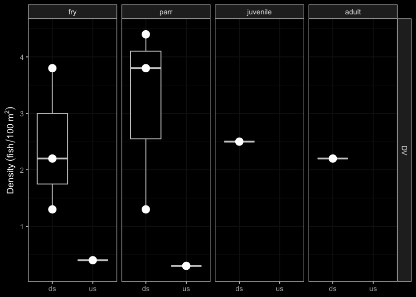
Figure 5.12: Densites of fish (fish/100m2) captured upstream and downstream of PSCIS crossing 8478.
my_photo1 = fpr::fpr_photo_pull_by_str(str_to_pull = 'ds_typical_1_')

my_caption1 = paste0('Typical habitat downstream of PSCIS crossing ', my_site, '.')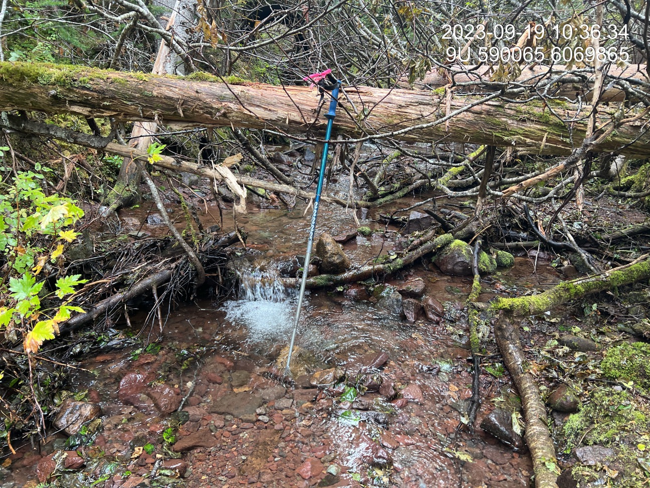
Figure 5.13: Typical habitat downstream of PSCIS crossing 8478.
my_photo2 = fpr::fpr_photo_pull_by_str(str_to_pull = 'us_typical_1')

my_caption2 = paste0('Typical habitat upstream of PSCIS crossing ', my_site, '.')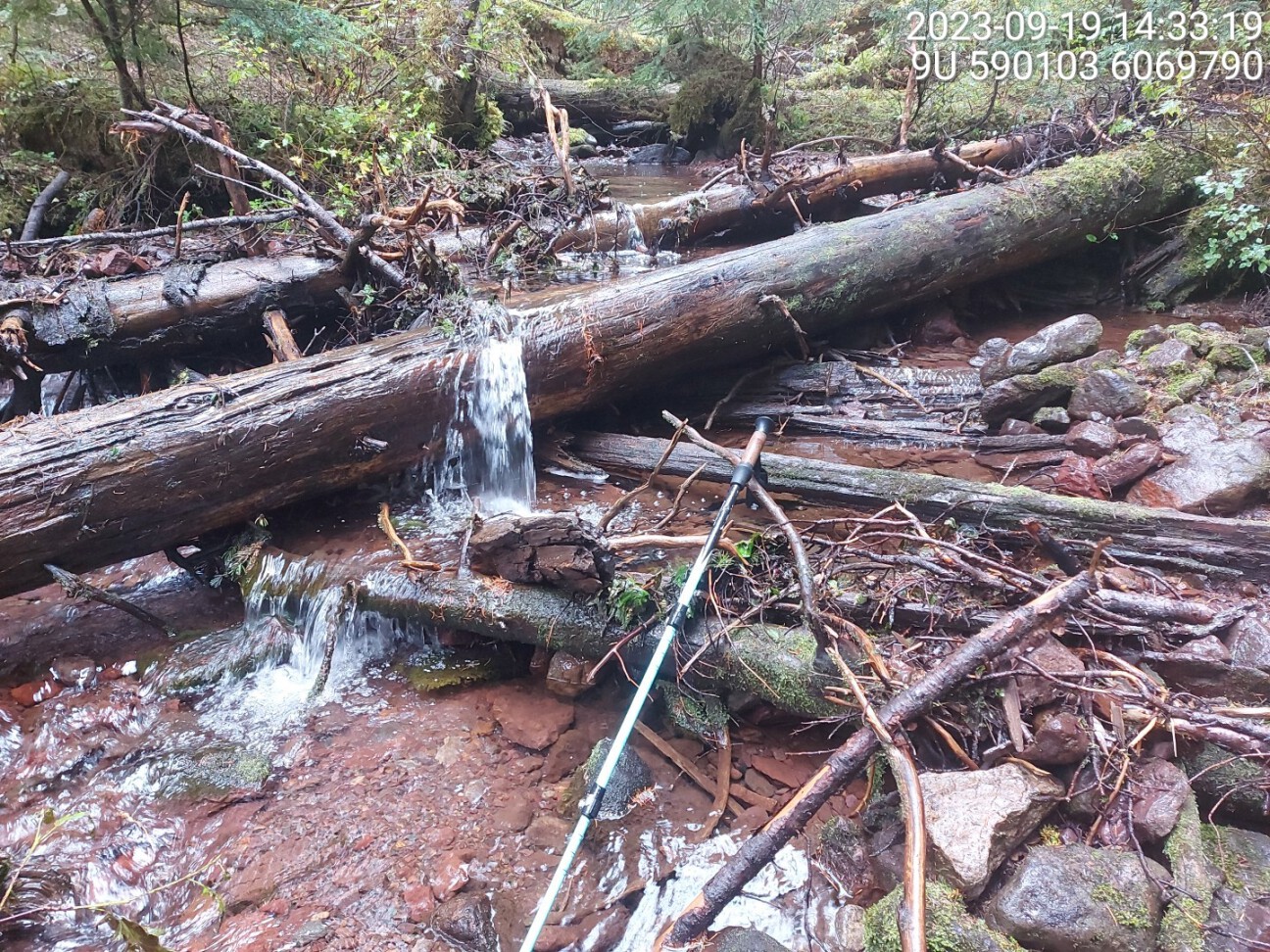
Figure 5.14: Typical habitat upstream of PSCIS crossing 8478.
my_caption <- paste0('Left: ', my_caption1, ' Right: ', my_caption2)

knitr::include_graphics(my_photo1)
knitr::include_graphics("fig/pixel.png")
knitr::include_graphics(my_photo2)
my_photo1 = fpr::fpr_photo_pull_by_str(str_to_pull = 'fish1')
my_caption1 = paste0('Dolly varden with deteriorating purple gill plates and unusual black spots captured downstream of crossing ', my_site, '.')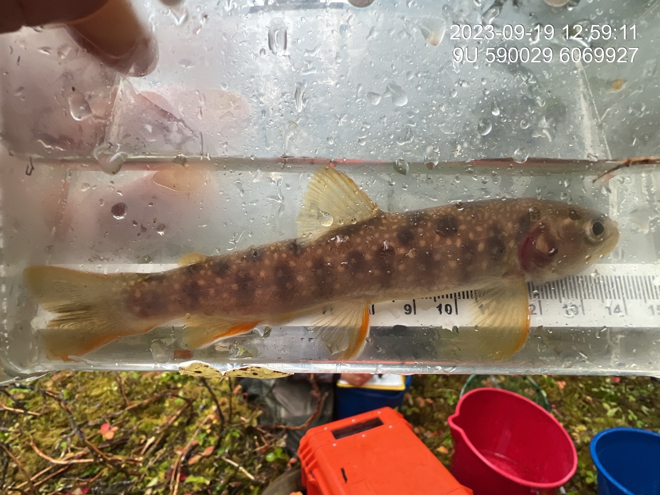
Figure 5.15: Dolly varden with deteriorating purple gill plates and unusual black spots captured downstream of crossing 8478.
my_photo2 = fpr::fpr_photo_pull_by_str(str_to_pull = 'f1_gills_')

my_caption2 = paste0('Dolly varden with deteriorating purple gill plates and unusual black spots captured upstream of crossing ', my_site, '.')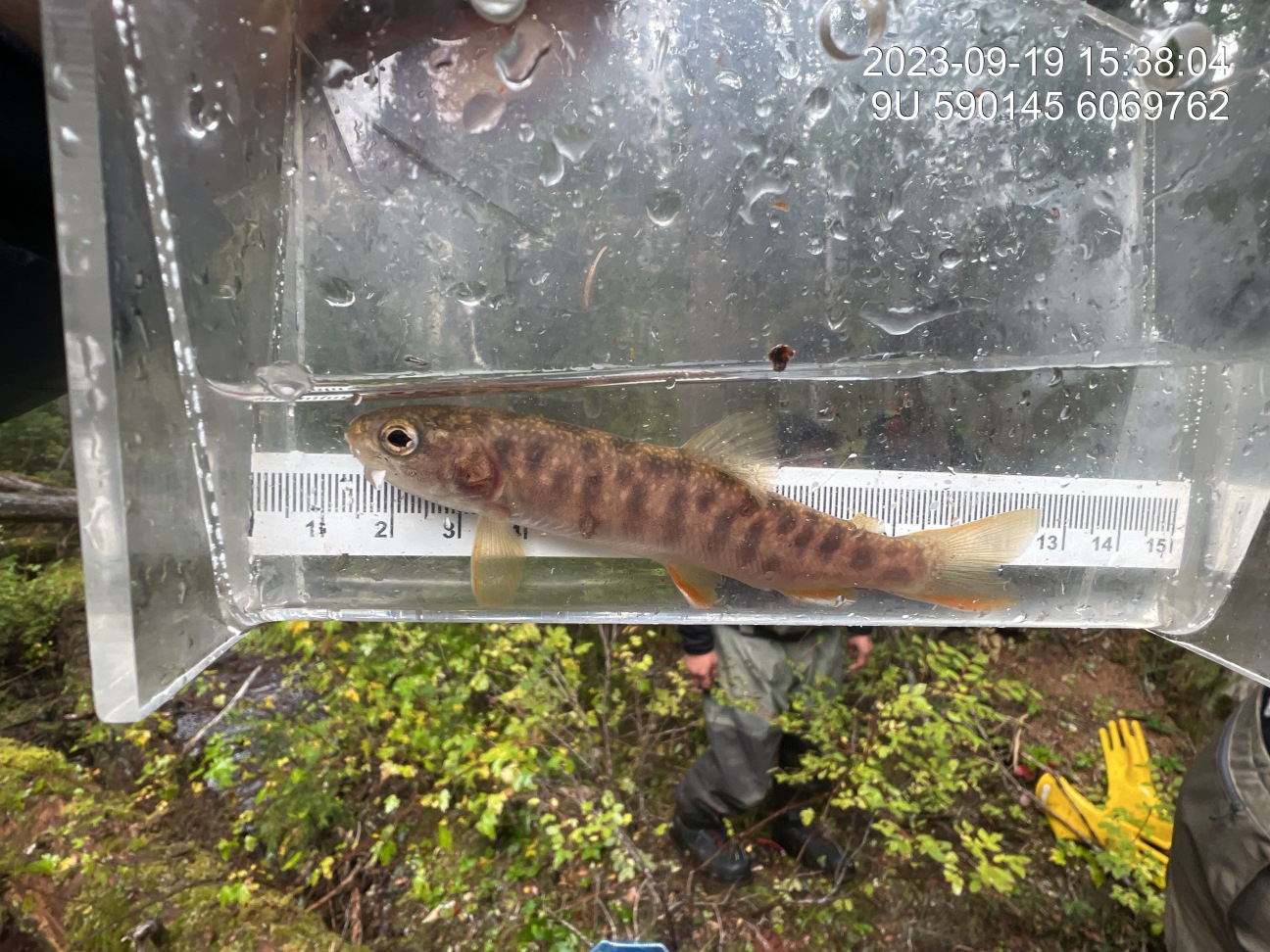
Figure 5.16: Dolly varden with deteriorating purple gill plates and unusual black spots captured upstream of crossing 8478.
my_caption <- paste0('Left: ', my_caption1, ' Right: ', my_caption2)

knitr::include_graphics(my_photo1)
knitr::include_graphics("fig/pixel.png")
knitr::include_graphics(my_photo2)