Tributary to Tagit Creek - 198022 & 197949 - Appendix
Site Location
PSCIS crossing 198022 and 197949 are located on Tributary to Tagit Creek, which flows in a southeast direction to Tagit Creek, approximately 45km west of Houston, BC within the Morice River watershed group. Crossing 198022 is located 0.2km upstream of Tagit Creek, and crossing 197949 a further 0.5km upstream. Downstream of the crossings, Tagit Creek flows southeast to Chisholm Lake then southwest to the Morice River approximately 5km downstream. Crossing 198022 is located on 9946-27 Rd with road tenure granted to West Fraser Mills Ltd. Crossing 197949 is located on a Spur of 9946-27 Rd and is the responsibility of the Ministry of Forest.
Background
Tributary to Tagit Creek is a second order stream with an upstream watershed area of approximately 4km2. The elevation of the watershed ranges from a maximum of 1379m to 815m near the lower crossing (Table 5.3).
In 2021, crossings 198022 and 197949 were assessed with fish passage assessments and prioritized for follow up with habitat confirmation assessments (Irvine 2021). Upstream of the crossing 198022, cutthroat trout have been documented in the past (Norris [2018] 2024; MoE 2024b).
fpr::fpr_table_wshd_sum(site_id = my_site) |>
  fpr::fpr_kable(caption_text = paste0('Summary of derived upstream watershed statistics for PSCIS crossing ', my_site, '.'),
                 footnote_text = 'Elev P60 = Elevation at which 60% of the watershed area is above',
scroll = F)| Site | Area Km | Elev Site | Elev Max | Elev Median | Elev P60 | Aspect |
|---|---|---|---|---|---|---|
| 198022 | 4 | 815 | 1379 | 1083 | 1034 | S |
| * Elev P60 = Elevation at which 60% of the watershed area is above |
A summary of habitat modelling outputs is presented in Table 5.4. A map of the watershed is provided in map attachment 093L.107.
| Habitat | Potential | Remediation Gain | Remediation Gain (%) |
|---|---|---|---|
| ST Network (km) | 6.7 | 0.5 | 7 |
| ST Lake Reservoir (ha) | 0.0 | 0.0 | – |
| ST Wetland (ha) | 1.4 | 0.0 | 0 |
| ST Slopeclass03 Waterbodies (km) | 0.2 | 0.0 | 0 |
| ST Slopeclass03 (km) | 0.4 | 0.0 | 0 |
| ST Slopeclass05 (km) | 0.6 | 0.5 | 83 |
| ST Slopeclass08 (km) | 2.2 | 0.0 | 0 |
| ST Spawning (km) | 0.0 | 0.0 | – |
| ST Rearing (km) | 1.6 | 0.5 | 31 |
| CH Spawning (km) | 0.0 | 0.0 | – |
| CH Rearing (km) | 0.5 | 0.5 | 100 |
| CO Spawning (km) | 0.5 | 0.5 | 100 |
| CO Rearing (km) | 0.5 | 0.5 | 100 |
| CO Rearing (ha) | 0.0 | 0.0 | – |
| SK Spawning (km) | 0.0 | 0.0 | – |
| SK Rearing (km) | 0.0 | 0.0 | – |
| SK Rearing (ha) | 0.0 | 0.0 | – |
| * Model data is preliminary and subject to adjustments. |
Stream Characteristics at Crossing 198022 and 197949
During the 2023 survey, both crossings were un-embedded, non-backwatered and ranked as a barrier to upstream fish passage according to the provincial protocol (MoE 2011) (Tables 5.5 - 5.6). Crossing 197949 had a 0.5m outlet drop with fish observed in the outlet pool. Water temperature was 6.5\(^\circ\)C, pH was 6.9 and conductivity was 267uS/cm.
| Location and Stream Data |
|
Crossing Characteristics | – |
|---|---|---|---|
| Date | 2023-09-27 | Crossing Sub Type | Round Culvert |
| PSCIS ID | 198022 | Diameter (m) | 1 |
| External ID | – | Length (m) | 14 |
| Crew | AI | Embedded | No |
| UTM Zone | 9 | Depth Embedded (m) | – |
| Easting | 614703 | Resemble Channel | No |
| Northing | 6009976 | Backwatered | No |
| Stream | Tributary to Tagit Creek | Percent Backwatered | – |
| Road | 9946-27 Rd | Fill Depth (m) | 2 |
| Road Tenure | West Fraser Mills Ltd. | Outlet Drop (m) | 0 |
| Channel Width (m) | 2.4 | Outlet Pool Depth (m) | 0 |
| Stream Slope (%) | 2 | Inlet Drop | No |
| Beaver Activity | Yes | Slope (%) | 2 |
| Habitat Value | Medium | Valley Fill | Deep Fill |
| Final score | 21 | Barrier Result | Barrier |
| Fix type | Replace with New Open Bottom Structure | Fix Span / Diameter | 15 |
Photos: From top left clockwise: Road/Site Card, Barrel, Outlet, Downstream, Upstream, Inlet.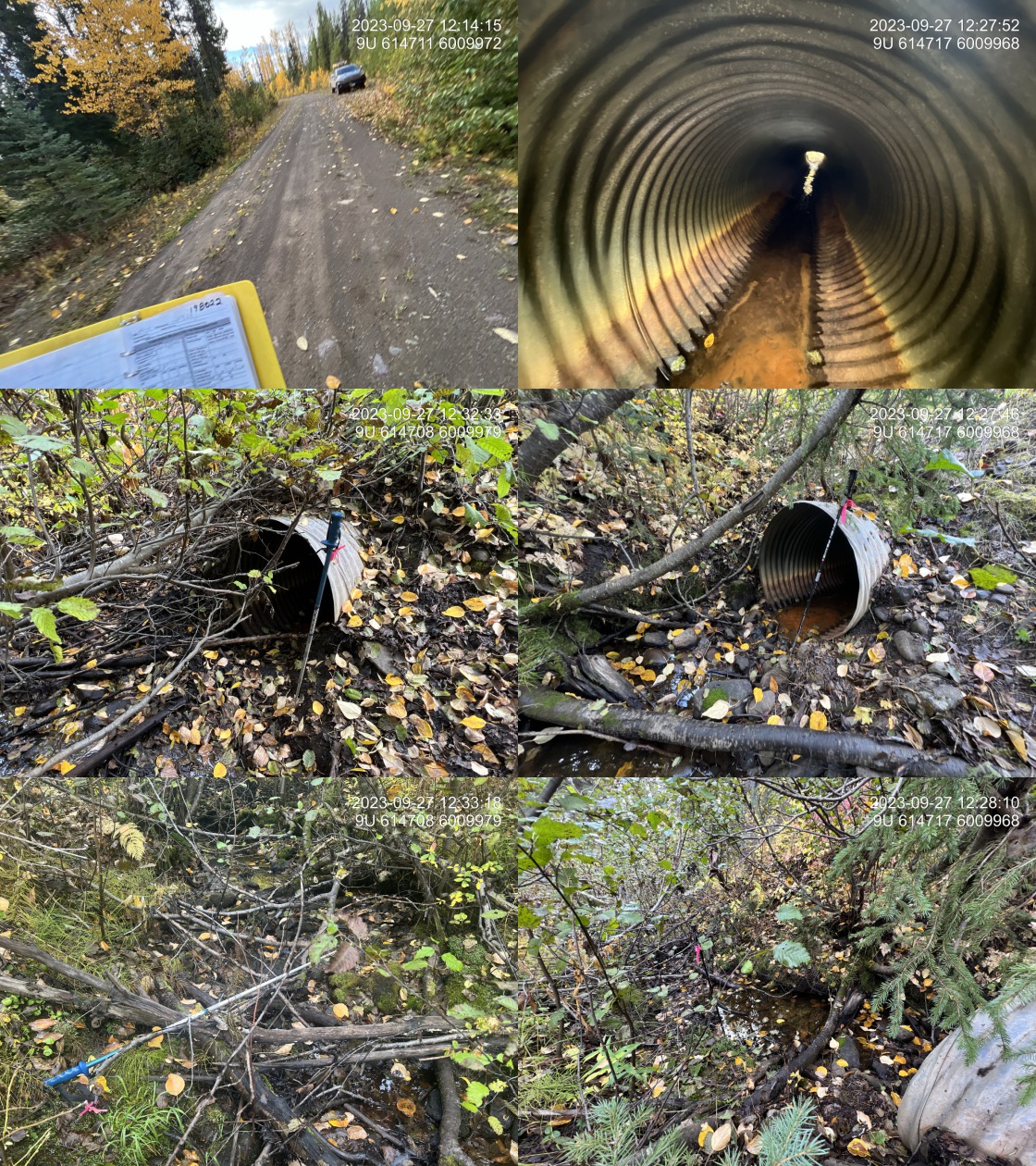
|
|||
| Comments: Moderate value habitat. Habitat confirmation conducted on stream, walked from upstream crossing down through wetland type area to culvert. Mostly dewatered besides small section above this crossing and below the upper crossing. Surveyed from upstream to down and ended up on road approximately 40 m to the north. Stream seems to merge with wetland type area just upstream of the road. Fish sampling conducted with dolly varden captured in small (2.5m2) outlet pool. Cutthroat are known to be upstream of crossing.. 12:12:45 |
| Location and Stream Data |
|
Crossing Characteristics | – |
|---|---|---|---|
| Date | 2023-09-27 | Crossing Sub Type | Round Culvert |
| PSCIS ID | 197949 | Diameter (m) | 1.2 |
| External ID | – | Length (m) | 14 |
| Crew | MW | Embedded | No |
| UTM Zone | 9 | Depth Embedded (m) | – |
| Easting | 614404 | Resemble Channel | No |
| Northing | 6010346 | Backwatered | No |
| Stream | Tributary to Tagit Creek | Percent Backwatered | – |
| Road | Spur | Fill Depth (m) | 1.2 |
| Road Tenure | MOF 9946 | Outlet Drop (m) | 0.5 |
| Channel Width (m) | 2.3 | Outlet Pool Depth (m) | 0.6 |
| Stream Slope (%) | 2 | Inlet Drop | No |
| Beaver Activity | No | Slope (%) | 2 |
| Habitat Value | High | Valley Fill | Deep Fill |
| Final score | 31 | Barrier Result | Barrier |
| Fix type | Replace with New Open Bottom Structure | Fix Span / Diameter | 15 |
Photos: From top left clockwise: Road/Site Card, Barrel, Outlet, Downstream, Upstream, Inlet.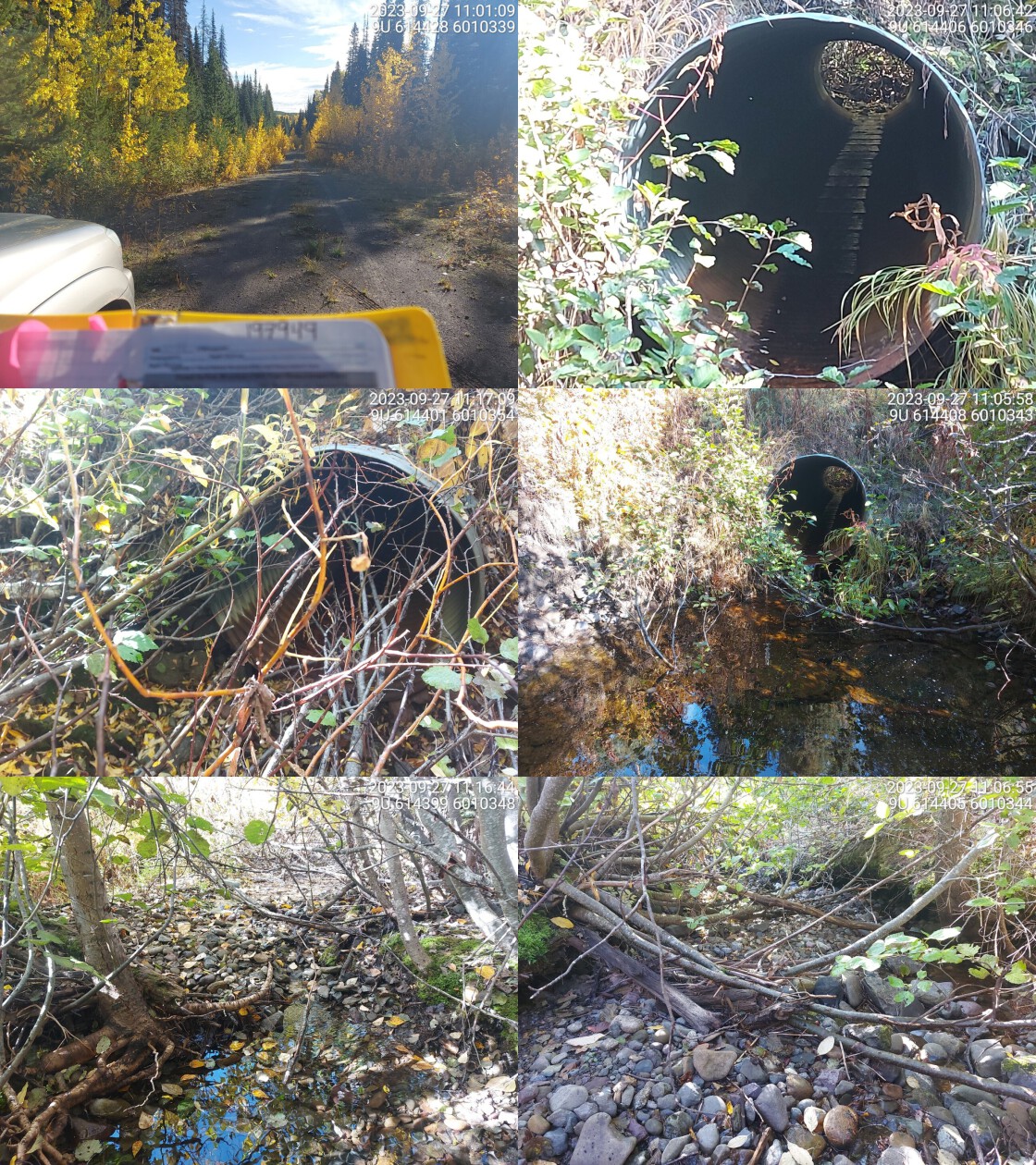
|
|||
| Comments: Numerous fish spotted in outlet pool. Low flow but water present upstream and downstream.. 11:10:01 |
Approximately 175m east on , crossing 198948 was also assessed. The crossing was located within the same network of stream channels and wetlands as the other two subject culverts but was not mapped within the Freshwater Atlas. The culvert was noted as rusting through with some blockage of the culvert inlet caused by a beaver dam. Photos and data are presented in Appendix - Phase 1 Fish Passage Assessments.
Stream Characteristics Downstream of Crossing 198022
The stream was surveyed downstream from crossing 198022 for 250m to the confluence with Tagit Creek. The first 100m of stream was noted as contained sporadic pools with a dewatered below. The stream flowed through a steep confined valley to Tagit Creek, where there was a large log jam at the confluence (Figure 5.2). The average channel width was 1.8m, the average wetted width was 0.2m, and the average gradient was 3%.The dominant substrate was cobbles with gravels sub-dominant.Total cover amount was rated as moderate with large woody debris dominant. Cover was also present as small woody debris and overhanging vegetation. The habitat was rated as medium value for salmonid rearing and spawning.
Stream Characteristics Upstream of Crossing 198022 and Downstream of Crossing 197949
The stream was surveyed for approximately 500m from the upper crossing 197949 to the lower crossing 198022 (Figure 5.4). Surveyors observed several fish in the outlet pool of the upper crossing. At the top end of the site there were occasional shallow pools and partial dewatering. At a location approximately 75m downstream of crossing 197949 (Spur), the stream dewatered. Total cover amount was rated as moderate with overhanging vegetation dominant. Cover was also present as small woody debris and undercut banks.The dominant substrate was gravels with fines sub-dominant.The average channel width was 2.5m, the average wetted width was 0.3m, and the average gradient was 3.8%. There were abundant gravels present suitable for spawning. Approximatley 300m from the lower crossing, the stream converged with a primarily dry, willow and sedge dominated wetland type area. The habitat was rated as medium for salmonid rearing and spawning.
Stream Characteristics Upstream of Crossing 197949
The stream was surveyed upstream from crossing 197949 for 550m . Flow levels were noted as low with occasional dewatered patches (Figure 5.5). There were few deep pools with fish observed throughout the areas surveyed. The average channel width was 2.3m, the average wetted width was 1m, and the average gradient was 6.8%.Total cover amount was rated as abundant with overhanging vegetation dominant. Cover was also present as small woody debris and large woody debris.The dominant substrate was cobbles with gravels sub-dominant. The habitat was rated as medium value for salmonid rearing and spawning.
Fish Sampling
Electrofishing was conducted above and below crossing 198022 with the upstream site located just below crossing 197949. The results are summarised in Tables 5.8 - 5.9 and Figure 5.1. A total of 17 cutthroat were captured upstream, and 1 dolly varden was captured downstream (Figures 5.6 - 5.7). All fish captured with a fork length greater than 60mm were tagged with Passive Integrated Transponders (PIT tags) with data stored here.
Structure Remediation and Cost Estimate
Should restoration/maintenance activities proceed, it is recommended that the crossings are replaced with 15m span bridges. The preliminary cost estimate for each bridge is $450,000.
Conclusion
There was 1.6km of steelhead rearing habitat modelled upstream of crossing 198022 with approximately 500m less modelled upstream of 197949. Electrofishing confirmed the stream provides habitat to cutthroat trout and dolly varden with habitat value rated as medium. The sites were ranked as moderate priorities for replacement.
tab_hab_summary %>%
  filter(Site %in% c(my_site, my_site2)) %>%
  # select(-Site) %>%
  fpr::fpr_kable(caption_text = paste0('Summary of habitat details for PSCIS crossing', my_site, 'and ', my_site2, '.'),
scroll = F) | Site | Location | Length Surveyed (m) | Channel Width (m) | Wetted Width (m) | Pool Depth (m) | Gradient (%) | Total Cover | Habitat Value |
|---|---|---|---|---|---|---|---|---|
| 197949 | Upstream | 550 | 2.3 | 1.0 | 0.4 | 6.8 | abundant | Medium |
| 198022 | Downstream | 250 | 1.8 | 0.2 | – | 3.0 | moderate | Medium |
| 198022 | Upstream | 500 | 2.5 | 0.3 | 0.2 | 3.8 | moderate | Medium |
| site | passes | ef_length_m | ef_width_m | area_m2 | enclosure |
|---|---|---|---|---|---|
| 198022_ds_ef1 | 1 | 2 | 1.25 | 2.5 | Open |
| 198022_us_ef1 | 1 | 4 | 4.05 | 16.2 | Open |
| local_name | species_code | life_stage | catch | density_100m2 | nfc_pass |
|---|---|---|---|---|---|
| 198022_ds_ef1 | DV | juvenile | 1 | 40.0 | FALSE |
| 198022_us_ef1 | CT | parr | 15 | 92.6 | FALSE |
| 198022_us_ef1 | CT | juvenile | 1 | 6.2 | FALSE |
| 198022_us_ef1 | CT | adult | 1 | 6.2 | FALSE |
|
* nfc_pass FALSE means fish were captured in final pass indicating more fish of this species/lifestage may have remained in site. Mark-recaptured required to reduce uncertainties. |
my_caption <- paste0('Densites of fish (fish/100m2) captured upstream and downstream of PSCIS crossing ', my_site, '.')

fpr_plot_fish_box() 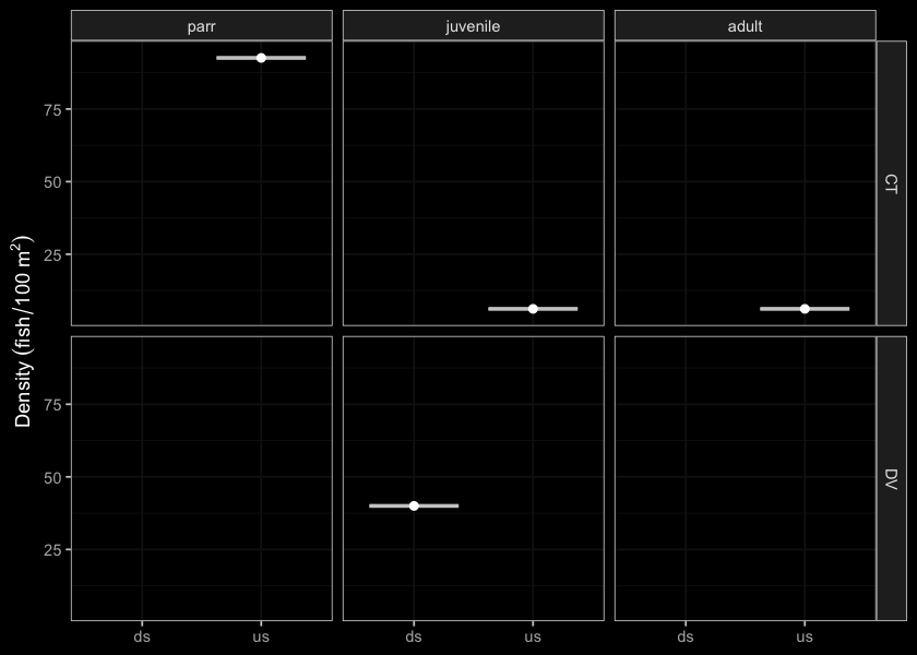
Figure 5.1: Densites of fish (fish/100m2) captured upstream and downstream of PSCIS crossing 198022.
my_photo1 = fpr::fpr_photo_pull_by_str(str_to_pull = 'ds_typical_2_')

my_caption1 = paste0('Typical habitat downstream of PSCIS crossing ', my_site, '.')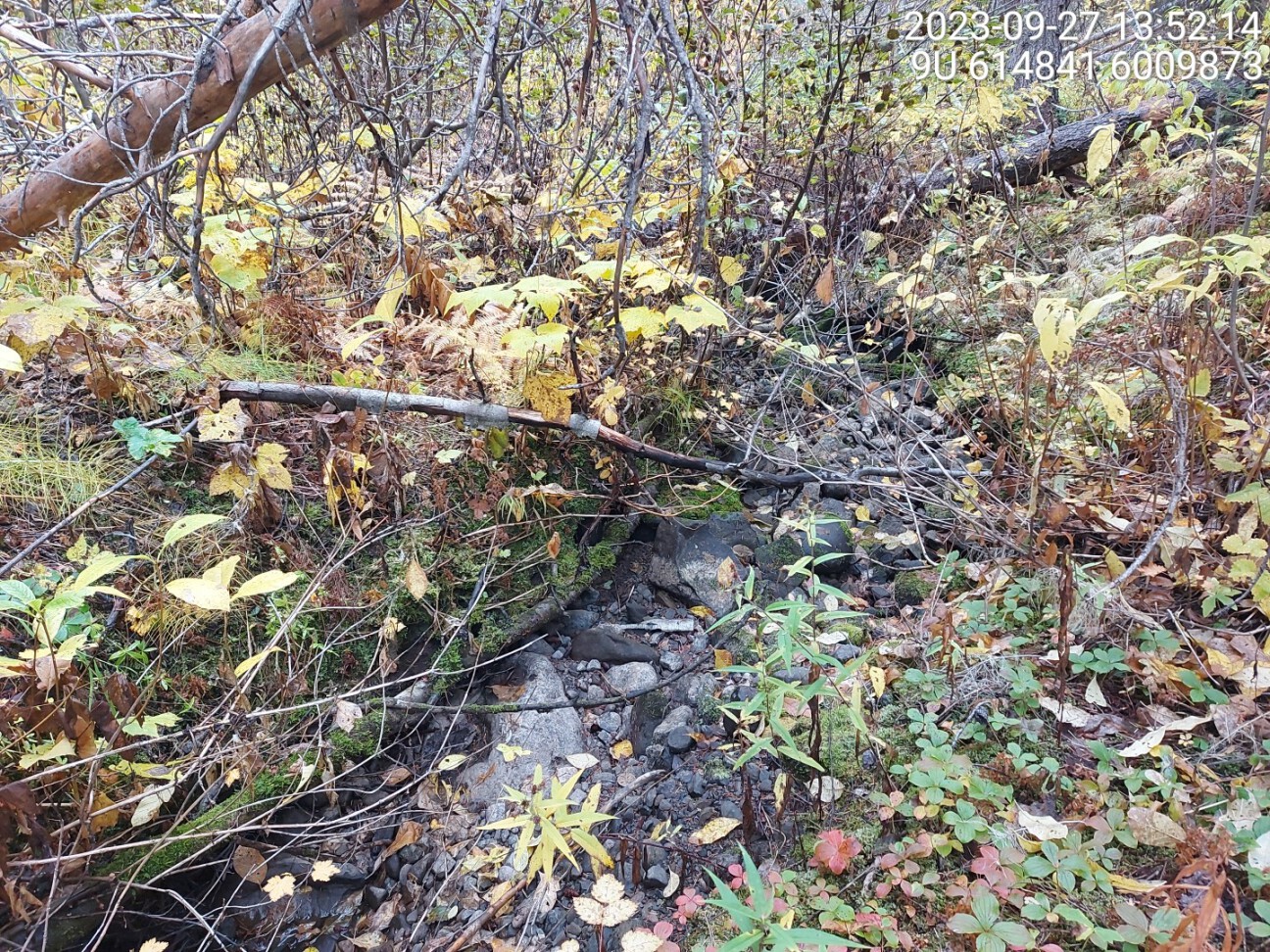
Figure 5.2: Typical habitat downstream of PSCIS crossing 198022.
my_photo2 = fpr::fpr_photo_pull_by_str(str_to_pull = 'ds_confluence')

my_caption2 = paste0('Log jam at the confluence with Tagit Creek.')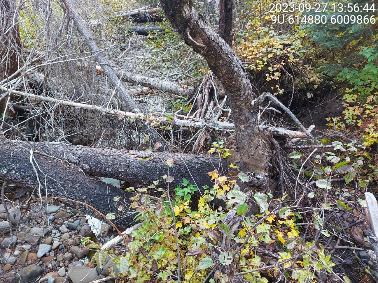
Figure 5.3: Log jam at the confluence with Tagit Creek.
my_caption <- paste0('Left: ', my_caption1, ' Right: ', my_caption2)

knitr::include_graphics(my_photo1)
knitr::include_graphics("fig/pixel.png")
knitr::include_graphics(my_photo2)
my_photo1 = fpr::fpr_photo_pull_by_str(str_to_pull = 'us_typical_2')
my_caption1 = paste0('Typical habitat upstream of PSCIS crossing ', my_site, ' and downstream of crossing ', my_site2, '.')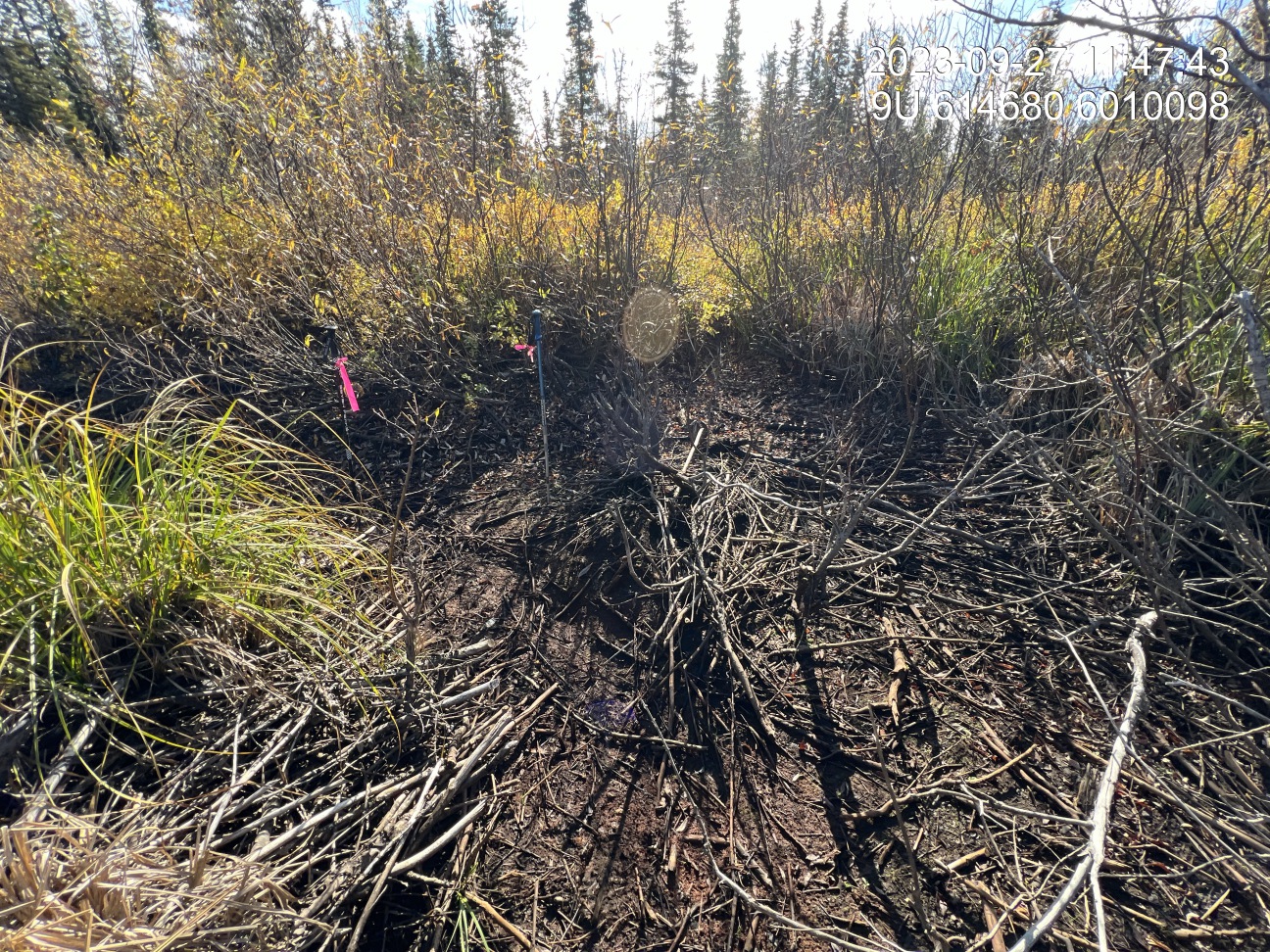
Figure 5.4: Typical habitat upstream of PSCIS crossing 198022 and downstream of crossing 197949.
my_photo2 = fpr::fpr_photo_pull_by_str(site = my_site2, str_to_pull = 'us_typical_1')

my_caption2 = paste0('Typical habitat upstream of PSCIS crossing ', my_site2, '.')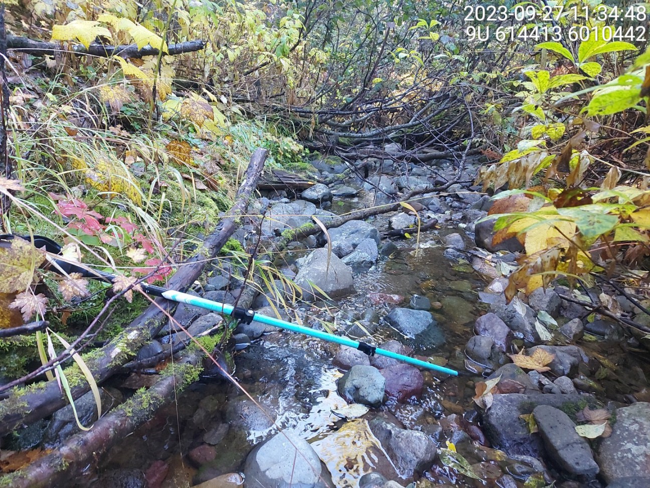
Figure 5.5: Typical habitat upstream of PSCIS crossing 197949.
my_caption <- paste0('Left: ', my_caption1, ' Right: ', my_caption2)

knitr::include_graphics(my_photo1)
knitr::include_graphics("fig/pixel.png")
knitr::include_graphics(my_photo2)
my_photo1 = fpr::fpr_photo_pull_by_str(str_to_pull = 'fish1')
my_caption1 = paste0('Cutthroat trout captured upstream of crossing ', my_site, '.')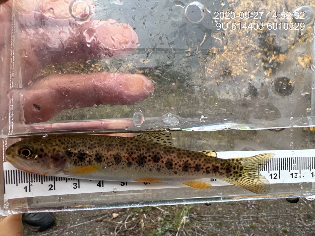
Figure 5.6: Cutthroat trout captured upstream of crossing 198022.
my_photo2 = fpr::fpr_photo_pull_by_str(str_to_pull = 'ef1_dv')

my_caption2 = paste0('Dolly varden captured downstream of crossing ', my_site, '.')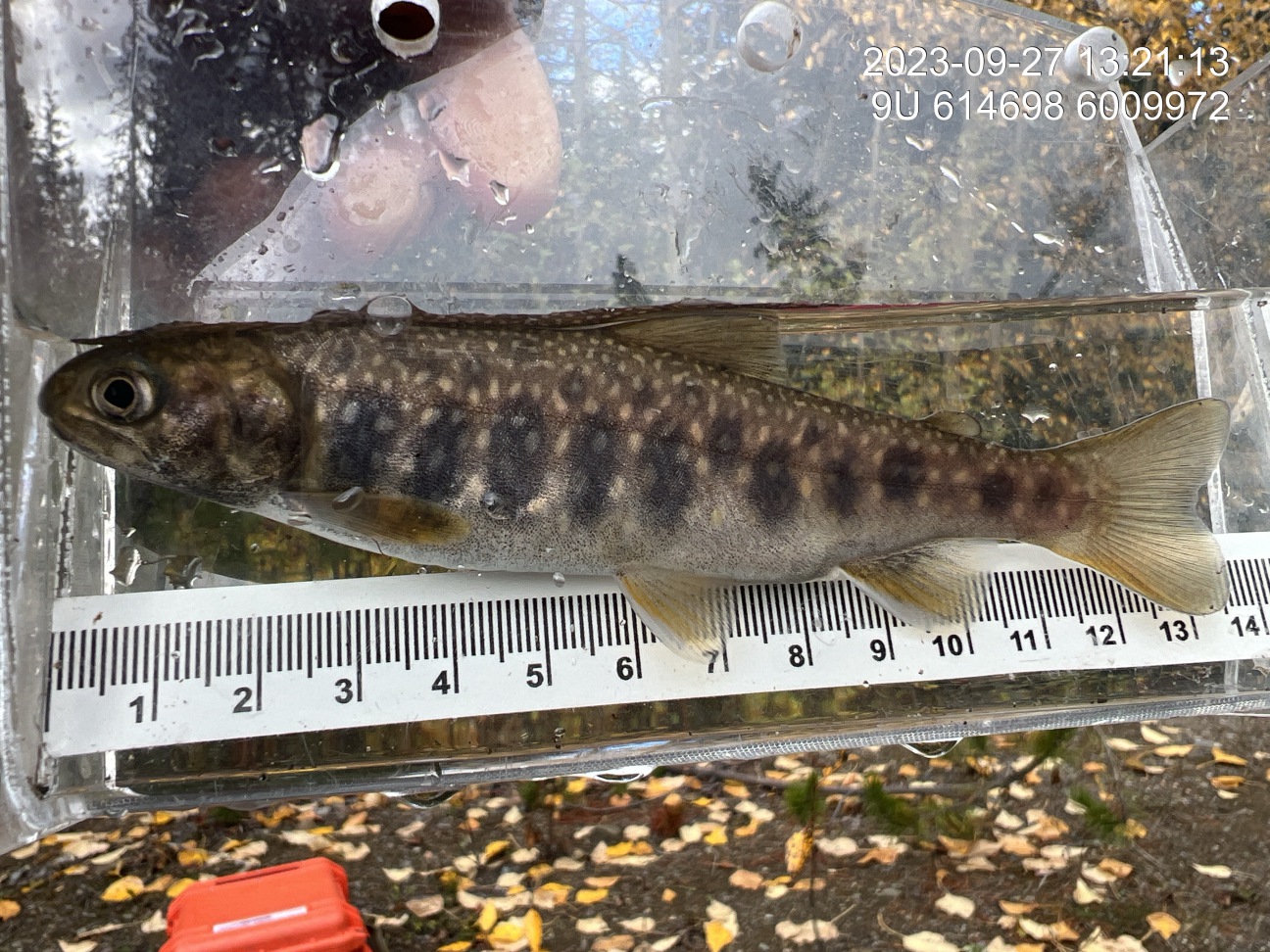
Figure 5.7: Dolly varden captured downstream of crossing 198022.
my_caption <- paste0('Left: ', my_caption1, ' Right: ', my_caption2)

knitr::include_graphics(my_photo1)
knitr::include_graphics("fig/pixel.png")
knitr::include_graphics(my_photo2)