Tributary to McDonell Lake - 8547 - Appendix
Site Location
PSCIS crossing 8547 on Tributary to McDonell Lake is located on the south side of the Zymoetz River approximately 1.6km upstream of McDonell Lake, on the McDonell Lake FSR. The road at the crossing location is the responsibility of the Wetzinkwa Community Forest Corporation.
Background
At crossing 8547, Tributary to McDonell Lake is a second order stream with an upstream watershed area of approximately 2.2km2. The elevation of the watershed ranges from a maximum of 1177m to 937m at the crossing (Table 5.31). The stream drains a small lake area estimated at 8.8ha in a south-east direction entering McDonell Lake approximately 1km west of the lake inlet.
The crossing was originally assessed with a fish passage assessment by Viveiros (2011) in 2010 with fish
sampling and replacement with an open bottomed structure recommended. The site was visited by our field crews in 2022
and prioritized for follow up with a habitat confirmation in 2024 because relatively good flow volumes were observed
along with a significant outlet drop. Upstream of the crossing, no past fish information was available
(Norris [2018] 2024; MoE 2024b) however a sockeye spawning location was noted as present within the
stream approximately 150m upstream from McDonell Lake and ~1200m downstream of the FSR. A modelled crossing was noted as
present within bcfishpass modelling outputs near the historic sockeye observation.
fpr::fpr_table_wshd_sum(site_id = my_site) %>%
  fpr::fpr_kable(caption_text = paste0('Summary of derived upstream watershed statistics for PSCIS crossing ', my_site, '.'),
           footnote_text = 'Elev P60 = Elevation at which 60% of the watershed area is above',
scroll = F)| Site | Area Km | Elev Site | Elev Max | Elev Median | Elev P60 | Aspect |
|---|---|---|---|---|---|---|
| 8547 | 2.2 | 937 | 1177 | 1086 | 1069 | SW |
| * Elev P60 = Elevation at which 60% of the watershed area is above |
A summary of habitat modelling outputs is presented in Table 5.32. A map of the watershed is provided in map attachment 093L.116.
| Habitat | Potential | Remediation Gain | Remediation Gain (%) |
|---|---|---|---|
| ST Network (km) | 0.7 | 0.7 | 100 |
| ST Lake Reservoir (ha) | 0.0 | 0.0 | – |
| ST Wetland (ha) | 0.0 | 0.0 | – |
| ST Slopeclass03 Waterbodies (km) | 0.0 | 0.0 | – |
| ST Slopeclass03 (km) | 0.0 | 0.0 | – |
| ST Slopeclass05 (km) | 0.7 | 0.7 | 100 |
| ST Slopeclass08 (km) | 0.0 | 0.0 | – |
| ST Spawning (km) | 0.0 | 0.0 | – |
| ST Rearing (km) | 0.0 | 0.0 | – |
| CH Spawning (km) | 0.0 | 0.0 | – |
| CH Rearing (km) | 0.0 | 0.0 | – |
| CO Spawning (km) | 0.0 | 0.0 | – |
| CO Rearing (km) | 0.0 | 0.0 | – |
| CO Rearing (ha) | 0.0 | 0.0 | – |
| SK Spawning (km) | 0.0 | 0.0 | – |
| SK Rearing (km) | 0.0 | 0.0 | – |
| SK Rearing (ha) | 0.0 | 0.0 | – |
| * Model data is preliminary and subject to adjustments. |
Stream Characteristics at Crossing
At the time of the survey in 2023, PSCIS crossing 8547 was un-embedded, non-backwatered, had an oulet drop of 0.7m and ranked as a barrier to upstream fish passage according to the provincial protocol (MoE 2011) (Table 5.33). Water temperature was 5.9\(^\circ\)C, pH was 7.9 and conductivity was 113uS/cm.
| Location and Stream Data |
|
Crossing Characteristics | – |
|---|---|---|---|
| Date | 2023-11-01 | Crossing Sub Type | Round Culvert |
| PSCIS ID | 8547 | Diameter (m) | 0.9 |
| External ID | – | Length (m) | 20 |
| Crew | AR AF | Embedded | No |
| UTM Zone | 9 | Depth Embedded (m) | – |
| Easting | 589988 | Resemble Channel | No |
| Northing | 6072657 | Backwatered | No |
| Stream | Tributary to McDonell Lake | Percent Backwatered | – |
| Road | McDonell Lake FSR | Fill Depth (m) | 3 |
| Road Tenure | Wetzinkwa Community Forest Corporation | Outlet Drop (m) | 0.7 |
| Channel Width (m) | 1.9 | Outlet Pool Depth (m) | 0.5 |
| Stream Slope (%) | 3 | Inlet Drop | No |
| Beaver Activity | No | Slope (%) | 3 |
| Habitat Value | High | Valley Fill | Deep Fill |
| Final score | 39 | Barrier Result | Barrier |
| Fix type | Replace Structure with Streambed Simulation CBS | Fix Span / Diameter | 3 |
Photos: From top left clockwise: Road/Site Card, Barrel, Outlet, Downstream, Upstream, Inlet.
|
|||
| Comments: 2 round culverts, one is not functional and was installed higher above stream channel. Culvert slope was estimated.CT observed in stream and historic CT FISS downstream.. 13:34:15 |
Stream Characteristics Downstream
The stream was surveyed downstream from crossing 8547 for 220m . This section of stream was shallow with slow moving water and had some shallow pools with large rocks for fish shelter.
(Figure 5.27).
Total cover amount was rated as moderate with large woody debris dominant. Cover was also present as small woody debris, boulders, undercut banks, and overhanging vegetation.The average channel width was 2m, the average wetted width was 0.7m, and the average gradient was 11%.The dominant substrate was boulders with cobbles sub-dominant. The habitat was rated as Medium value for salmonid rearing and spawning.
Approximately 1.2km downstream of the FSR, the location of PSCIS crossing 24600461 was also assessed. The
crossing had been removed. The stream was surveyed upstream the mapped location of crossing 24600461 for 100m.
The dominant substrate was gravels with cobbles sub-dominant.Total cover amount was rated as moderate with large woody debris dominant. Cover was also present as small woody debris, undercut banks, and overhanging vegetation.The average channel width was 2.3m, the average wetted width was 1.3m, and the average gradient was 4.8%. There were abundant gravels, few deep pools, and multiple shallow pools up to 20-25cm deep (Figure 5.28).
Surveyors observed numerous fry and parr and noted the stream had good flow considering the time of year and low flows
observed elsewhere in the watershed. The habitat was rated as high
value for salmonid rearing and spawning.
Stream Characteristics Upstream
The stream was surveyed upstream from crossing 8547 for 500m (Figure 5.29). The average channel width was 1.9m, the average wetted width was 1.2m, and the average gradient was 5.6%.Total cover amount was rated as moderate with small woody debris dominant. Cover was also present as large woody debris, undercut banks, and overhanging vegetation.The dominant substrate was cobbles with gravels sub-dominant. The stream channel was small and moderately steep, with modest flow. There were very few areas with gravels suitable for spawning and not many deep pools. Other than the culvert no natural or anthroprogenic barriers were observed. The habitat was rated as medium for salmonid rearing and spawning.
Fish Sampling
Electrofishing was conducted at three sites above and three sites below the FSR crossing, with results summarised in Tables 5.35 - 5.36 and Figure 5.26. A total of 19 fish were captured upstream and 15 fish were captured downstream, all of which were cutthroat trout (Figures 5.30) All fish captured with a fork length greater than 60mm were tagged with Passive Integrated Transponders (PIT tags) with data stored here.
Structure Remediation and Cost Estimate
Should restoration/maintenance activities proceed, replacement of PSCIS crossing 8547 with an embedded culvert (streambed simulation) (3m span) is recommended. A preliminary cost of the work is estimated at $100,000.
Conclusion
Electrofishing surveys in 2023 captured cutthrout trout upstream and downstream of the FSR with densities of fish captured indicating the stream is productive and provides habitat suitable for rearing and spawning. The small lake at the headwaters of the stream likely moderates water temperature and flows in the system providing a suitable environment for salmonids. Habitat upstream of the crossing was rated as medium value for salmonid rearing and spawning with the site rated as a moderate priority for replacement. As the stream is relatively small, it may be possible to replace the crossing with a streambed simulation culvert (embedded 3m pipe) to provide fish passage and maintain the natural stream channel while providing a cost effective solution.
tab_hab_summary %>%
  filter(Site  == my_site) %>%
  # select(-Site) %>%
  fpr::fpr_kable(caption_text = paste0('Summary of habitat details for PSCIS crossing ', my_site, '.'),
scroll = F) | Site | Location | Length Surveyed (m) | Channel Width (m) | Wetted Width (m) | Pool Depth (m) | Gradient (%) | Total Cover | Habitat Value |
|---|---|---|---|---|---|---|---|---|
| 8547 | Downstream | 220 | 2.0 | 0.7 | 0.2 | 11.0 | moderate | Medium |
| 8547 | Downstream2 | 100 | 2.3 | 1.3 | 0.2 | 4.8 | moderate | High |
| 8547 | Upstream | 500 | 1.9 | 1.2 | 0.4 | 5.6 | moderate | Medium |
| site | passes | ef_length_m | ef_width_m | area_m2 | enclosure |
|---|---|---|---|---|---|
| 8547_ds_ef1 | 1 | 50 | 1.57 | 78.5 | Open |
| 8547_ds_ef2 | 1 | 18 | 1.35 | 24.3 | Open |
| 8547_ds_ef3 | 1 | 3 | 1.90 | 5.7 | Open |
| 8547_us_ef1 | 1 | 15 | 1.07 | 16.0 | Open |
| 8547_us_ef2 | 1 | 12 | 1.10 | 13.2 | Open |
| 8547_us_ef3 | 1 | 12 | 1.60 | 19.2 | Open |
| local_name | species_code | life_stage | catch | density_100m2 | nfc_pass |
|---|---|---|---|---|---|
| 8547_ds_ef1 | CT | fry | 3 | 3.8 | FALSE |
| 8547_ds_ef1 | CT | parr | 1 | 1.3 | FALSE |
| 8547_ds_ef2 | CT | fry | 5 | 20.6 | FALSE |
| 8547_ds_ef2 | CT | parr | 4 | 16.5 | FALSE |
| 8547_ds_ef3 | CT | parr | 1 | 17.5 | FALSE |
| 8547_ds_ef3 | CT | juvenile | 1 | 17.5 | FALSE |
| 8547_us_ef1 | CT | fry | 4 | 25.0 | FALSE |
| 8547_us_ef2 | CT | fry | 5 | 37.9 | FALSE |
| 8547_us_ef2 | CT | parr | 3 | 22.7 | FALSE |
| 8547_us_ef3 | CT | fry | 4 | 20.8 | FALSE |
| 8547_us_ef3 | CT | parr | 3 | 15.6 | FALSE |
|
* nfc_pass FALSE means fish were captured in final pass indicating more fish of this species/lifestage may have remained in site. Mark-recaptured required to reduce uncertainties. |
my_caption <- paste0('Densites of fish (fish/100m2) captured upstream and downstream of PSCIS crossing ', my_site, '.')

fpr_plot_fish_box() 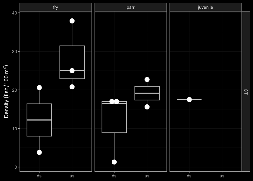
Figure 5.26: Densites of fish (fish/100m2) captured upstream and downstream of PSCIS crossing 8547.
my_photo1 = fpr::fpr_photo_pull_by_str(str_to_pull = 'ds_typical_2')

my_caption1 = paste0('Typical habitat downstream of PSCIS crossing ', my_site, '.')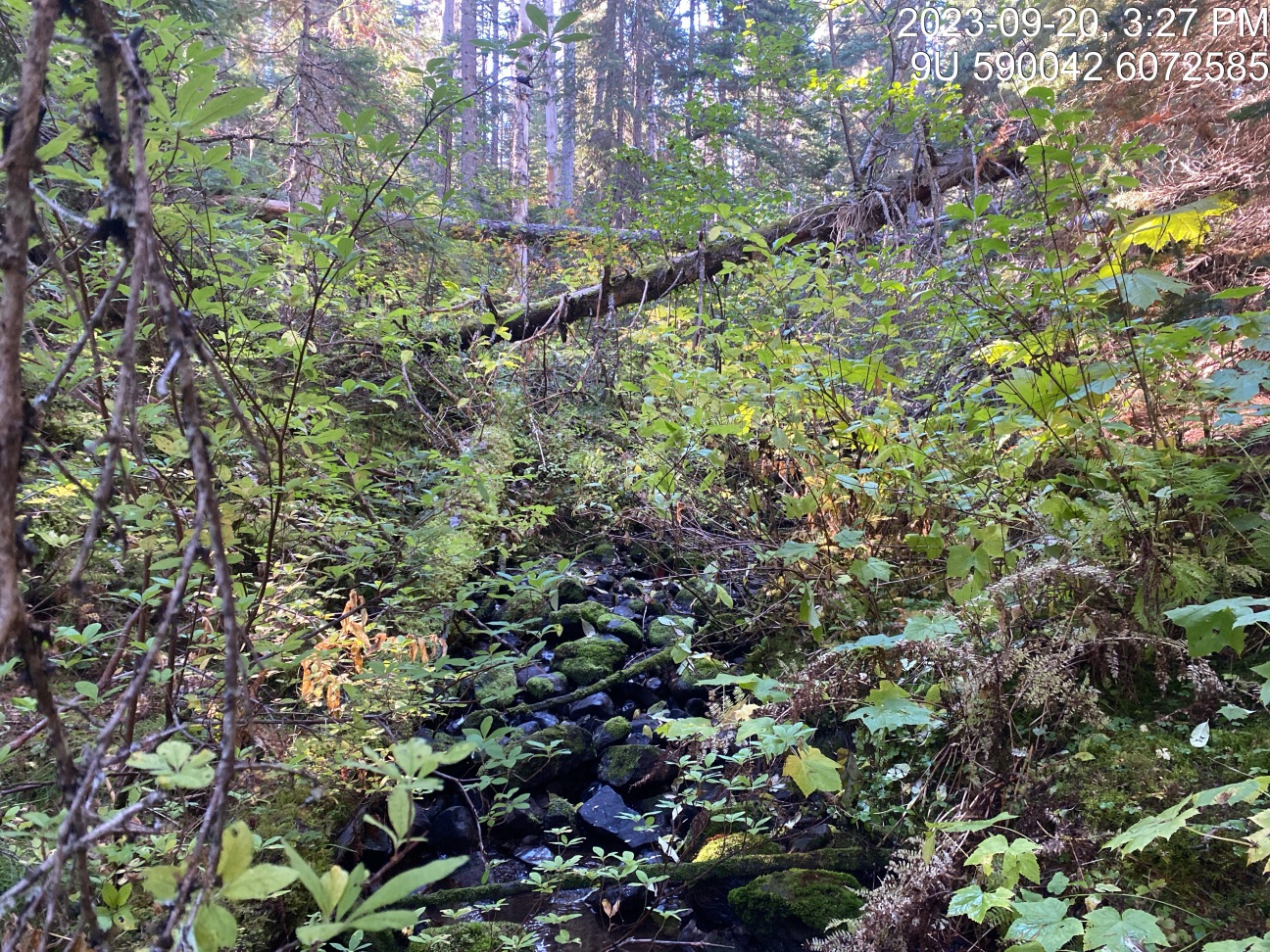
Figure 5.27: Typical habitat downstream of PSCIS crossing 8547.
my_photo2 = fpr::fpr_photo_pull_by_str(str_to_pull = 'ds2_typical_1')

my_caption2 = paste0('Typical habitat downstream of PSCIS crossing ', my_site2, '.')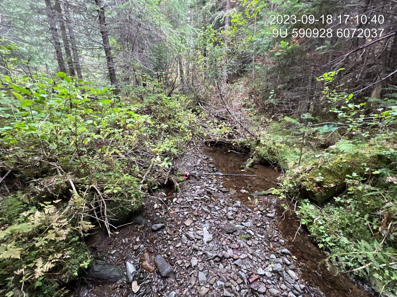
Figure 5.28: Typical habitat downstream of PSCIS crossing 24600461.
my_caption <- paste0('Left: ', my_caption1, ' Right: ', my_caption2)

knitr::include_graphics(my_photo1)
knitr::include_graphics("fig/pixel.png")
knitr::include_graphics(my_photo2)
my_photo1 = fpr::fpr_photo_pull_by_str(str_to_pull = '_us_typical_1')
my_caption1 = paste0('Typical habitat upstream of PSCIS crossing ', my_site, '.')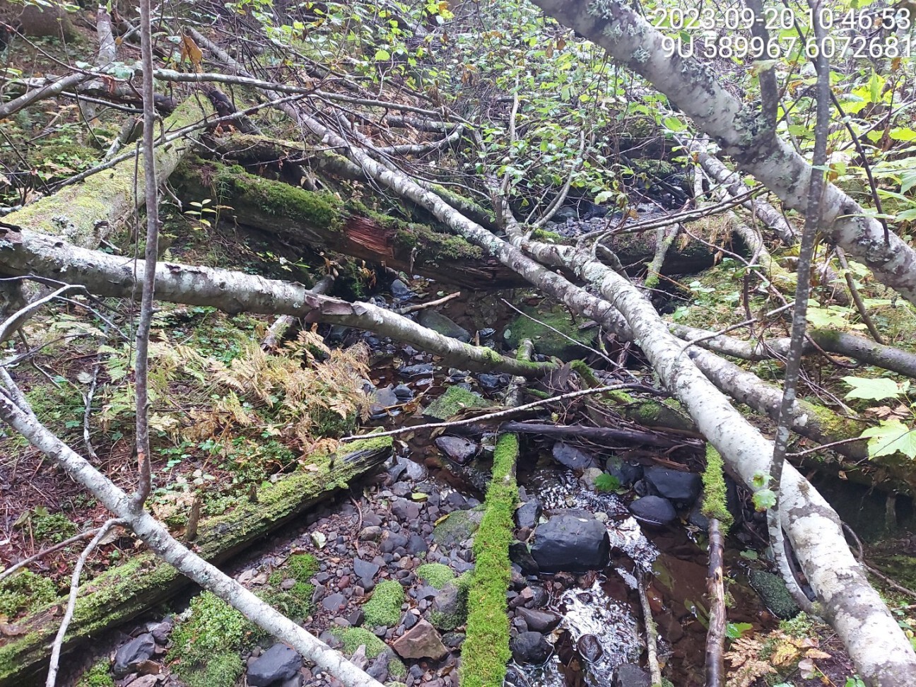
Figure 5.29: Typical habitat upstream of PSCIS crossing 8547.
my_photo2 = fpr::fpr_photo_pull_by_str(str_to_pull = 'fish2')

my_caption2 = paste0('Cutthroat trout captured upstream of crossing ', my_site, '.')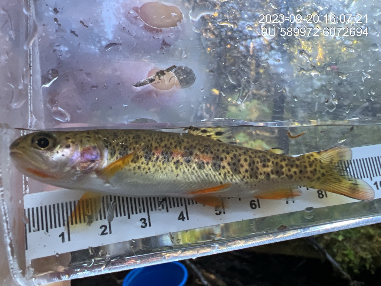
Figure 5.30: Cutthroat trout captured upstream of crossing 8547.