Tributary to Houston Tommy Creek - 198934 & 198942 - Appendix
Site Location
Crossings 198934 and 198942 are located on a Tributary to Houston Tommy Creek, approximately 2.1km and 3km upstream of Houston Tommy Creek. The stream flows southeast to Houston Tommy Creek, which then flows roughly 9km west to its confluence with the Morice River. The sites are located approximately 30km southwest of Houston, BC.
The upper crossing (PSCIS 198942) is located on Holland Rd and crossing 198934 on a spur of Holland Rd. Both roads are documented as the responsibility of Canfor R07549 within the Forest Tenure Road Section Lines spatial layer distributed by BC Data Catalogue (MoE 2024a).
Background
At crossings 198934 and 198942, Tributary to Houston Tommy Creek is a third order stream with an upstream watershed area of approximately 11.7km2. The elevation of the watershed ranges from a maximum of 1336m to 826m at the lower crossing 198934 (Table 5.10).
Review of MoE (2024d) indicates that in 2002 upstream of the Holland Road spur and crossing 198934 stream sample sites were assessed in by Triton Environmental Consultants with fish captured and some detail on fish distribution in the watershed provided within submitted site card notes.
Crossing 198934 was ranked as a moderate priority for field assessment during planning activities conducted in 2022 due to significant quantities of modelled habitat upstream. Following a fish passage assessment in 2023, surveyors conducted habitat confirmation assessments for both 198934 and 198942 as the crossings ranked as barriers to fish passage and because habitat quality and stream flow levels appeared above average when compared to other small culverted streams in the area. In the past, rainbow trout and dolly varden have been documented upstream of crossing 198934 (Norris [2018] 2024; MoE 2024b).
fpr::fpr_table_wshd_sum(site_id = my_site) |>
  fpr::fpr_kable(caption_text = paste0('Summary of derived upstream watershed statistics for PSCIS crossing ', my_site, '.'),
           footnote_text = 'Elev P60 = Elevation at which 60% of the watershed area is above',
scroll = F)| Site | Area Km | Elev Site | Elev Max | Elev Median | Elev P60 | Aspect |
|---|---|---|---|---|---|---|
| 198934 | 11.7 | 826 | 1336 | 1012 | 976 | S |
| * Elev P60 = Elevation at which 60% of the watershed area is above |
A summary of habitat modelling outputs are presented in Table 5.11. A map of the watershed is provided in map attachment 093L.108.
| Habitat | Potential | Remediation Gain | Remediation Gain (%) |
|---|---|---|---|
| ST Network (km) | 16.5 | 0.9 | 5 |
| ST Lake Reservoir (ha) | 1.2 | 0.0 | 0 |
| ST Wetland (ha) | 22.0 | 0.0 | 0 |
| ST Slopeclass03 Waterbodies (km) | 2.5 | 0.0 | 0 |
| ST Slopeclass03 (km) | 1.4 | 0.0 | 0 |
| ST Slopeclass05 (km) | 5.0 | 0.0 | 0 |
| ST Slopeclass08 (km) | 6.0 | 0.9 | 15 |
| ST Spawning (km) | 0.2 | 0.0 | 0 |
| ST Rearing (km) | 4.6 | 0.9 | 20 |
| CH Spawning (km) | 0.2 | 0.0 | 0 |
| CH Rearing (km) | 0.2 | 0.0 | 0 |
| CO Spawning (km) | 2.0 | 0.0 | 0 |
| CO Rearing (km) | 3.4 | 0.0 | 0 |
| CO Rearing (ha) | 0.0 | 0.0 | – |
| SK Spawning (km) | 0.0 | 0.0 | – |
| SK Rearing (km) | 0.0 | 0.0 | – |
| SK Rearing (ha) | 0.0 | 0.0 | – |
| * Model data is preliminary and subject to adjustments. |
Stream Characteristics at Crossings 198934 and 198942
During the 2023 survey, PSCIS crossing 198934 was found to be un-embedded, non-backwatered, and classified as a barrier to upstream fish passage according to the provincial protocol (MoE 2011) (Table 5.12). The culvert was bent in the middle and had a significant outlet drop of 0.7m. Water temperature was 6\(^\circ\)C, pH was 8.7 and conductivity was 147uS/cm. Of note, the crossing had an estimated 8m of road fill above the culvert.
PSCIS crossing 198934 was un-embedded, non-backwatered and ranked as a barrier to upstream fish passage according to the provincial protocol (MoE 2011) (Table 5.12). The culvert was noted as in good condition with a deep outlet pool, suggesting the pipe was undersized.
| Location and Stream Data |
|
Crossing Characteristics | – |
|---|---|---|---|
| Date | 2023-09-12 | Crossing Sub Type | Round Culvert |
| PSCIS ID | 198934 | Diameter (m) | 1.6 |
| External ID | – | Length (m) | 18 |
| Crew | MW | Embedded | No |
| UTM Zone | 9 | Depth Embedded (m) | – |
| Easting | 631703 | Resemble Channel | No |
| Northing | 6017418 | Backwatered | No |
| Stream | Tributary to Houston Tommy Creek | Percent Backwatered | – |
| Road | Spur | Fill Depth (m) | 8 |
| Road Tenure | Canfor R07549 | Outlet Drop (m) | 0.7 |
| Channel Width (m) | 3.3 | Outlet Pool Depth (m) | 0.5 |
| Stream Slope (%) | 3 | Inlet Drop | No |
| Beaver Activity | No | Slope (%) | 4 |
| Habitat Value | High | Valley Fill | Deep Fill |
| Final score | 39 | Barrier Result | Barrier |
| Fix type | Replace Structure with Streambed Simulation CBS | Fix Span / Diameter | 4.5 |
Photos: From top left clockwise: Road/Site Card, Barrel, Outlet, Downstream, Upstream, Inlet.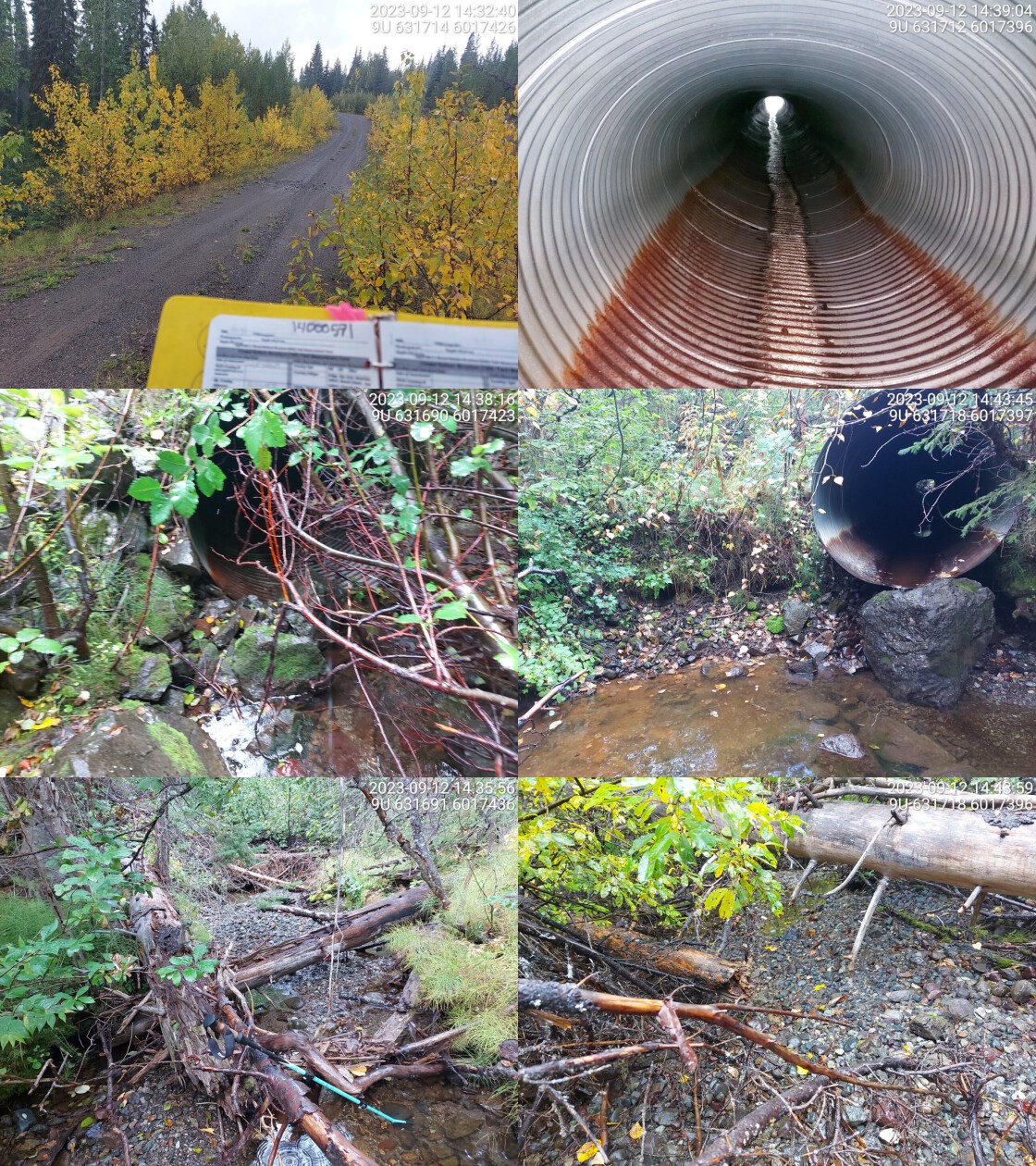
|
|||
| Comments: Very good habitat upstream and downstream. Culvert is a little bent in the middle. Big outlet drop, fish spotted in outlet pool. Moderate flowing stream.. 14:35:45 |
| Location and Stream Data |
|
Crossing Characteristics | – |
|---|---|---|---|
| Date | 2023-09-12 | Crossing Sub Type | Round Culvert |
| PSCIS ID | 198942 | Diameter (m) | 1.2 |
| External ID | – | Length (m) | 14 |
| Crew | MW | Embedded | No |
| UTM Zone | 9 | Depth Embedded (m) | – |
| Easting | 631508 | Resemble Channel | No |
| Northing | 6018096 | Backwatered | No |
| Stream | Tributary to Houston Tommy Creek | Percent Backwatered | – |
| Road | Holland Rd | Fill Depth (m) | 0.7 |
| Road Tenure | Canfor R07549 | Outlet Drop (m) | 0.1 |
| Channel Width (m) | 1.9 | Outlet Pool Depth (m) | 0.7 |
| Stream Slope (%) | 2 | Inlet Drop | No |
| Beaver Activity | No | Slope (%) | 1 |
| Habitat Value | High | Valley Fill | Deep Fill |
| Final score | 21 | Barrier Result | Barrier |
| Fix type | Replace Structure with Streambed Simulation CBS | Fix Span / Diameter | 3 |
Photos: From top left clockwise: Road/Site Card, Barrel, Outlet, Downstream, Upstream, Inlet.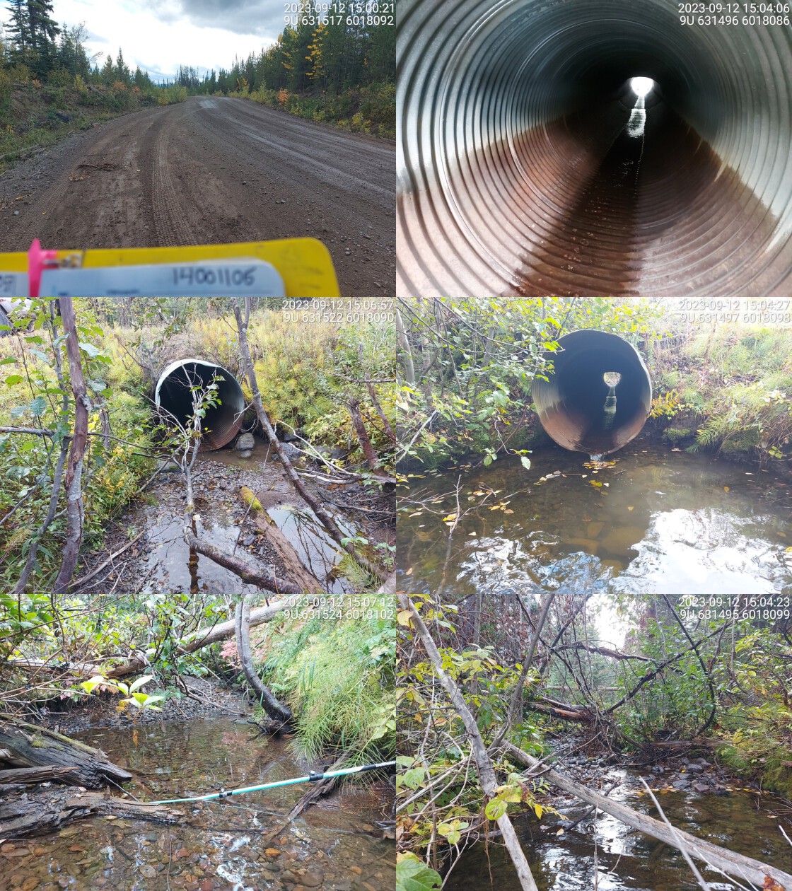
|
|||
| Comments: Deep outlet pool, culvert may be undersized. Relatively wide stream with good habitat, dolly varden confirmed downstream in the past.. 15:05:09 |
Stream Characteristics Downstream of 198934
The stream was surveyed downstream from crossing 198934 for 275m (Figure 5.8). The dominant substrate was cobbles with gravels sub-dominant.Total cover amount was rated as moderate with large woody debris dominant. Cover was also present as small woody debris, undercut banks, and overhanging vegetation.The average channel width was 3.2m, the average wetted width was 2.1m, and the average gradient was 2.7%. Surveyor notes indicate pockets of gravel suitable for resident salmonid spawning and occasional deep pools for overwintering. Fish (<150mm - species unconfirmed) were observed in the outlet pool of the culvert. Overall, habitat was rated as medium value for salmonid rearing and spawning.
Stream Characteristics Upstream of 198934 and Downstream of 198942
The stream was surveyed the entire distance from crossing 198934 to crossing 198942 on Holland Rd(~850m) (Figure 5.9). The average channel width was 3.3m, the average wetted width was 1.7m, and the average gradient was 5.5%.Total cover amount was rated as moderate with deep pools dominant. Cover was also present as small woody debris, large woody debris, boulders, and overhanging vegetation.The dominant substrate was cobbles with gravels sub-dominant. In the area surveyed, the stream contained abundant gravels suitable for spawning and occasional pools. Approximately 300m downstream of Holland Rd, on the left bank, there was a landslide roughly 30m high and 30m long (Figure 5.10). Below the landslide, it was noted that aggraded sediments had caused the stream to go sub-surface for a distance of approximately 300m with only occasional pools containing water. Fish were observed in the outlet pool of crossing 198942. The habitat was rated as medium value for salmonid rearing and spawning.
Stream Characteristics Upstream of 198942
The stream was surveyed upstream from crossing 198942 for 650m (Figure 5.11). The average channel width was 1.9m, the average wetted width was 1.5m, and the average gradient was 3.8%.The dominant substrate was gravels with fines sub-dominant.Total cover amount was rated as abundant with large woody debris dominant. Cover was also present as small woody debris, undercut banks, and overhanging vegetation. Flow levels were noted as moderate with occasional deep pools present suitable for resident fish overwintering.
The stream forked at a location approximately 200 meters upstream of Holland Rd, and the west fork was assessed for a further 650m. Roughly 1.1km upstream on the east fork, rainbow trout have been documented in the past with survey notes indicating a falls present near the location of fish capture that likely limits the upstream distribution of fish (Norris [2018] 2024; MoE 2024b). Although MoE (2024c) indicates that the falls noted is not documented in provincial databases, the 300m long site in which the falls is noted begins at a point on the eastern most fork of the stream approximately 1.3km upstream of Holland Rd. The habitat in the area surveyed was rated as medium value for salmonid rearing and spawning.
Structure Remediation and Cost Estimate
Should restoration/maintenance activities proceed, it is recommended to replace crossings 198934 and 198942 with embedded culverts (streambed simulation), with spans of 4.5m and 3m, respectively. While these estimates are preliminary, the rough cost of the work for each crossing is estimated at $100,000. However, 8m of road fill was noted as above crossing 198934, which will likely significantly increase the cost of replacement.
Conclusion
bcfishpass modelling indicates over 3km of potential steelhead rearing habitat upstream of crossing 198942 with habitat rated as medium value. Conducting fish sampling at the site site may provide data useful for further guiding prioritization particularly if genetic analysis could determine if
somw of the fish utilizing the stream are progeny of anadromous steelhead.
tab_hab_summary %>%
  filter(Site %in% c(my_site, my_site2)) %>%
  # select(-Site) %>%
  fpr::fpr_kable(caption_text = paste0('Summary of habitat details for PSCIS crossing ', my_site, '.'),
scroll = F) | Site | Location | Length Surveyed (m) | Channel Width (m) | Wetted Width (m) | Pool Depth (m) | Gradient (%) | Total Cover | Habitat Value |
|---|---|---|---|---|---|---|---|---|
| 198934 | Downstream | 275 | 3.2 | 2.1 | 0.4 | 2.7 | moderate | Medium |
| 198934 | Upstream | 850 | 3.3 | 1.7 | 0.5 | 5.5 | moderate | Medium |
| 198942 | Upstream | 650 | 1.9 | 1.5 | 0.4 | 3.8 | abundant | Medium |
my_photo1 = fpr::fpr_photo_pull_by_str(str_to_pull = 'ds_typical_2')

my_caption1 = paste0('Typical habitat downstream of PSCIS crossing ', my_site, '.')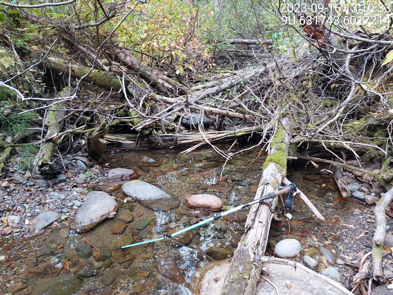
Figure 5.8: Typical habitat downstream of PSCIS crossing 198934.
my_photo2 = fpr::fpr_photo_pull_by_str(str_to_pull = 'us_typical_2')

my_caption2 = paste0('Typical habitat upstream of PSCIS crossing ', my_site, ' and downstream of PSCIS crossing ', my_site2,'.')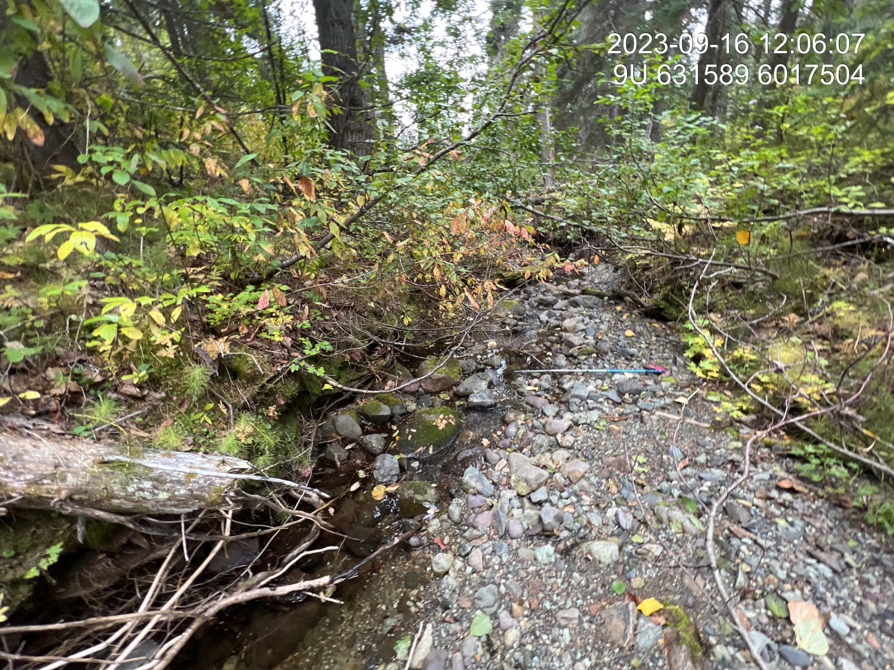
Figure 5.9: Typical habitat upstream of PSCIS crossing 198934 and downstream of PSCIS crossing 198942.
my_caption <- paste0('Left: ', my_caption1, ' Right: ', my_caption2)

knitr::include_graphics(my_photo1)
knitr::include_graphics("fig/pixel.png")
knitr::include_graphics(my_photo2)
my_photo1 = fpr::fpr_photo_pull_by_str(str_to_pull = 'landslide')
my_caption1 = paste0('Landslide located 300m downstream of crossing ', my_site2, '.')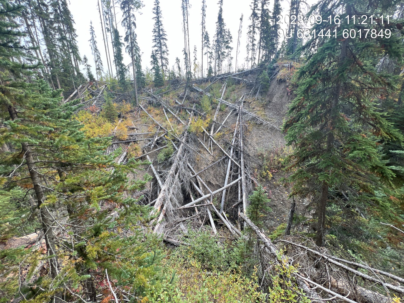
Figure 5.10: Landslide located 300m downstream of crossing 198942.
my_photo2 = fpr::fpr_photo_pull_by_str(site = my_site2, str_to_pull = 'us_typical_1')

my_caption2 = paste0('Typical habitat upstream of PSCIS crossing ', my_site2,'.')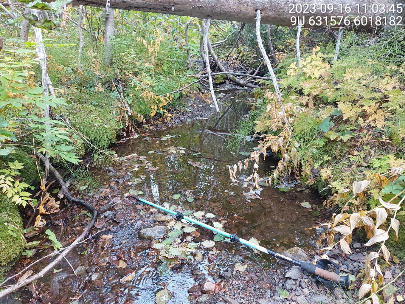
Figure 5.11: Typical habitat upstream of PSCIS crossing 198942.
my_caption <- paste0('Left: ', my_caption1, ' Right: ', my_caption2)

knitr::include_graphics(my_photo1)
knitr::include_graphics("fig/pixel.png")
knitr::include_graphics(my_photo2)