Alvin Creek - 197379 - Appendix
Site Location
PSCIS crossing 197379 is located on Alvin Creek 28km south-west of Houston, BC at approximately km 29.8 on the Morice-Owen Forest Service Road (FSR), approximately 0.2km upstream from the confluence with the Owen River. The stream is known locally as Alvin Creek, draining Alvin Lake however the naming convention is not documented for either the stream or the lake within the freshwater atlas of BC. This memo was previously titled “Tributary to Owen Creek - 197379”.
At the time of reporting in 2023, the Huckleberry Multi-Use Site was located immediately south of the subject stream at a location of approximately 1.1km upstream of the FSR. A remote workcamp, the site is reported as housing up to 800-1200 workers employed to construct TC Energy’s Coastal GasLink (CGL) pipeline project. Water for the camp (150,000 litres/day) was trucked in from the District of Houston with with another 150,000 litres/day of effluent trucked back to Houston from disposal (Burns Lake Lakes District News 2022). This memo was originally drafted in 2023 but has been updated in the spring of 2024 with new information.
Background
At crossing 197379, Alvin Creek is a third order stream with a watershed area upstream of the crossing of approximately 32.9km2. The elevation of the watershed ranges from a maximum of 1418m to 672m at the crossing (Table 5.1). Upstream of crossing 197379, coho salmon and rainbow trout have previously been recorded (Norris 2022). A total of 67ha of lake and 129ha of wetland is modelled upstream of the Forest Service Road (Table 5.2). PSCIS stream crossing 197379 was ranked as a moderate priority for follow up by Irvine (2021) with notes indicating than 1km of potential habitat but a very large channel width recorded in past PSCIS assessment. A map of the watershed is provided in map attachment 093L.103.
A habitat confirmation assessment was conducted at the site in 2021 with the site revisited in the summers of 2022 (September 15) and 2023 (September 13) for fish sampling (electrofishing and tagging).
fpr::fpr_table_wshd_sum(site_id = my_site) %>%
  select(-'Elev Min') %>%
  fpr::fpr_kable(caption_text = paste0('Summary of derived upstream watershed statistics for PSCIS crossing ', my_site, '.'),
           footnote_text = 'Elev P60 = Elevation at which 60% of the watershed area is above',
scroll = F)| Site | Area Km | Elev Site | Elev Max | Elev Median | Elev P60 | Aspect |
|---|---|---|---|---|---|---|
| 197379 | 32.9 | 672 | 1418 | 931 | 909 | SSW |
| * Elev P60 = Elevation at which 60% of the watershed area is above |
| Habitat | Potential | Remediation Gain | Remediation Gain (%) |
|---|---|---|---|
| ST Network (km) | 0.8 | 0.8 | 100 |
| ST Lake Reservoir (ha) | – | 0.0 | – |
| ST Wetland (ha) | – | 0.0 | – |
| ST Slopeclass03 Waterbodies (km) | 0.0 | 0.0 | – |
| ST Slopeclass03 (km) | 0.1 | 0.1 | 100 |
| ST Slopeclass05 (km) | 0.0 | 0.0 | – |
| ST Slopeclass08 (km) | 0.7 | 0.7 | 100 |
| ST Spawning (km) | 0.1 | 0.1 | 100 |
| ST Rearing (km) | 0.8 | 0.8 | 100 |
| CH Spawning (km) | 0.1 | 0.1 | 100 |
| CH Rearing (km) | 0.1 | 0.1 | 100 |
| CO Spawning (km) | 0.1 | 0.1 | 100 |
| CO Rearing (km) | 0.1 | 0.1 | 100 |
| CO Rearing (ha) | – | 0.0 | – |
| SK Spawning (km) | 0.0 | 0.0 | – |
| SK Rearing (km) | 0.0 | 0.0 | – |
| SK Rearing (ha) | – | 0.0 | – |
| * Model data is preliminary and subject to adjustments. |
Stream Characteristics at Crossing
At the time of the survey, PSCIS crossing 197379 had an outlet drop of 0.5m, was un-embedded, non-backwatered and ranked as a barrier to upstream fish passage according to the provincial protocol (MoE 2011b) (Table 5.3). Water temperature was 12\(^\circ\)C, pH was 7.9 and conductivity was 249uS/cm.
| Location and Stream Data |
|
Crossing Characteristics | – |
|---|---|---|---|
| Date | 2021-09-07 | Crossing Sub Type | Round Culvert |
| PSCIS ID | 197379 | Diameter (m) | 1.5 |
| External ID | – | Length (m) | 26 |
| Crew | KP | Embedded | No |
| UTM Zone | 9 | Depth Embedded (m) | – |
| Easting | 640960.8 | Resemble Channel | No |
| Northing | 6005930 | Backwatered | No |
| Stream | Alvin Creek | Percent Backwatered | – |
| Road | Morice-Owen FSR | Fill Depth (m) | 5 |
| Road Tenure | FLNR DND 9947 | Outlet Drop (m) | 0.47 |
| Channel Width (m) | 6.4 | Outlet Pool Depth (m) | 0.9 |
| Stream Slope (%) | 4.8 | Inlet Drop | No |
| Beaver Activity | No | Slope (%) | 1.5 |
| Habitat Value | High | Valley Fill | Deep Fill |
| Final score | 34 | Barrier Result | Barrier |
| Fix type | Replace with New Open Bottom Structure | Fix Span / Diameter | 19 |
Photos: From top left clockwise: Road/Site Card, Barrel, Outlet, Downstream, Upstream, Inlet.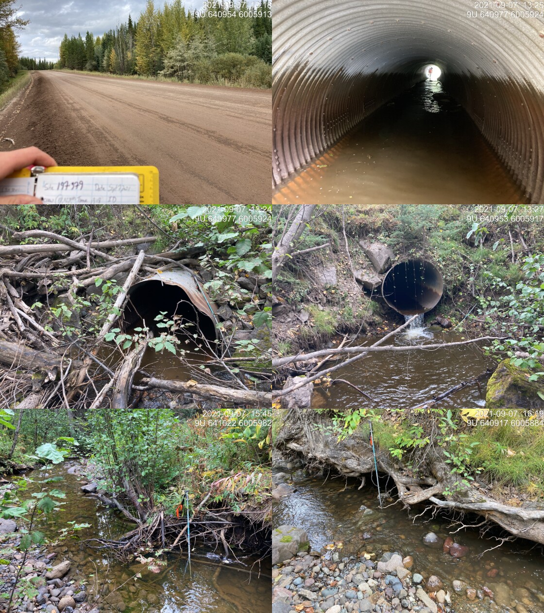
|
|||
| Comments: Two thirds of culvert on upstream side has baffles. Fish sampling and PIT tagging conducted. Design underway by MoF. 13:18 |
Stream Characteristics Downstream
The stream was surveyed downstream from crossing 197379 for 190m (Figures 5.2 - 5.3). Total cover amount was rated as moderate with overhanging vegetation dominant. Cover was also present as small woody debris and undercut banks.The average channel width was 4.3m, the average wetted width was 2.6m, and the average gradient was 3.3%.The dominant substrate was cobbles with gravels sub-dominant. The stream had signs of high flow due to eroded banks. Habitat below the culvert was rated as medium value with likely important rearing areas for coho and steelhead rearing during high flow events in the Owen Creek mainstem.
Stream Characteristics Upstream
The stream was surveyed for 800m in a downstream direction to the culvert from the location of an approximately 8m high waterfall (Figures 5.4 - 5.7). The average channel width was 6.4m, the average wetted width was 3.1m, and the average gradient was 4.8%.The dominant substrate was cobbles with gravels sub-dominant.Total cover amount was rated as moderate with undercut banks dominant. Cover was also present as small woody debris, large woody debris, deep pools, and overhanging vegetation. Near the falls, bedrock dominated the stream substrate and the gradient was noted as 7%. The mixed decidous and coniferous forest riparian was noted as healthy. Pockets of gravel suitable for coho, steelhead and resident rainbow trout/cutthrout trout were observed. Overall, the habitat upstream of the FSR was rated as high value, containing habitat suitable for rearing and spawning of both anadromous as well as resident fish species. Of note, when the site was revisited in 2022 the stream was primarily dewatered with numerous fish concentrated within isolated pools.
Fish Sampling
Electrofishing results from sampling conducted in 2022 is summarised in Tables 5.5 - 5.6 and Figure 5.1. A total of 35 fish were captured upstream and 30 fish were captured downstream (Figures 5.8 - 5.9). Although coho, dolly varden, rainbow trout and cutthrout trout (rainbow and cutthrout were potentially hybrd rainbow/cutthrout) parr (likely 1 year old fish) were captured downstream of the crossing, only rainbow trout and cutthrout trout were captured upstream. As noted, the stream was mostly dry at the time of electrofishing, with fish concentrated in pools. All fish over 60mm that were captured were tagged with Passive Integrated Transponders (PIT tags) with data stored here.
The site was revisited in 2023 to resample to build the state of knowledge related to fish health and movement however no water was present in areas fished in 2022 with the exception of a very small outlet pool. One fish was observed in the outlet pool in 2023 (rainbow trout ~110mm long with no tag present) and one PIT tag was discovered in a dry area of the channel downstream near the outlet pool (fish had died). All areas fished in 2022 - both upstream and downstream of the FSR - were scanned with PIT tag reader in 2023 however only the one tag was discovered downstream.
Structure Remediation and Cost Estimate
Should restoration/maintenance activities proceed, replacement of PSCIS crossing 197379 with a bridge (19m span) is recommended. The cost of the work was estimated by Mark Dewit (Ministry of Forest Area Engineer) at $800,000 for a cost benefit of 1 linear m/$1000 and 3.4 m2/$1000 with the relatively high costs of the work predicted primarily related to the large amount of road fill present at the site, the large width of the two lane FSR and the subsequent significant excavation required to install the large replacement structure.
Conclusion
Crossing 197379 on Alvin Creek was assessed for habitat characteristics in 2021 and for fish composition in 2022 and 2023. As electrofishing in 2022 captured coho, dolly varden, rainbow trout and cutthrout trout downstream of the crossing and only rainbow trout and cutthrout trout upstream, it appears as though the culvert was functioning as a barrier to upstream migration. Although,the absence of coho and dolly varden upstream of the crossing does indicate that these species were not able to migrate upstream through the crossing structure in the years previous to sampling it does not imply that rainbow and cutthrout could ascend as these species are likely resident within the watershed upstream of Morice-Owen Forest Service Road. Dry conditions within the stream in 2024 prevented insights into fish migration and health as no live tagged fish were present in the dewatered stream. Nevertheless, fish tagged during 2022 assessments may be present in the stream in future years and scanning fish captured in the stream with a PIT tag reader in the future will provide insight into fish movement and growth/health in the system if previously tagged fish are captured.
Although intermittent streams experience periods without streamflow, residual pools within these systems can provide valuable habitat for juvenile salmon encouraging high growth rates and subsequent increased rates of overwinter survival (Ebersole et al. 2006; Wigington Jr et al. 2006). Wigington Jr et al. (2006) measured overwinter survival rates of fish utilizing intermittent tributaries as higher than those in mainstem habitats with survival rates equivalent of those in perennial streams. They noted that fish tagged in mainstems moved into intermittent tributaries when streamflow resumed in the fall and hypothesized that use of residual pools during dry periods and migration into these systems during times of increased flow can result in positive outcomes for these fish due to lower competitive fish densities and higher food resources when compared to coho in perennial tributary habitat. Both Ebersole et al. (2006) and Wigington Jr et al. (2006) measured coho smolts from intermittent streams as considerably larger than those that used perennial habitats leading to greater overwinter survival illustrating the importance of maintaining connectivity in these systems.
There was 0.8km of habitat upstream of the culvert between the Morice-Owen FSR and the 8m high waterfall with habitat rated in 2022 as high value for coho, steelhead and resident rainbow/cuthrout rearing and spawning. Crossing 197379 was ranked as a high priority for proceeding to design for replacement. At the time of reporting in 2024, a design for a replacement structure to more effectively facilitate upstream migration for all fish life stages and species had been developed by Mark Dewit from the Ministry of Forests. Additionally, the Office of Wet’suwet’en has initiated watershed level Nation led recovery/restoration planning for the greater Bii Wenii Kwa (Owen Creek) watershed which includes restoration of this site as a project priority consideration.
tab_hab_summary %>%
  filter(Site  == my_site) %>%
  fpr::fpr_kable(caption_text = paste0('Summary of habitat details for PSCIS crossing ', my_site, '.'),
scroll = F) | Site | Location | Length Surveyed (m) | Channel Width (m) | Wetted Width (m) | Pool Depth (m) | Gradient (%) | Total Cover | Habitat Value |
|---|---|---|---|---|---|---|---|---|
| 197379 | Downstream | 190 | 4.3 | 2.6 | 0.3 | 3.3 | moderate | medium |
| 197379 | Upstream | 800 | 6.4 | 3.1 | 0.7 | 4.8 | moderate | high |
| site | passes | ef_length_m | ef_width_m | area_m2 | enclosure |
|---|---|---|---|---|---|
| 197379_ds_ef1 | 1 | 5 | 5.0 | 25.0 | Open |
| 197379_us_ef1 | 1 | 11 | 1.7 | 18.7 | Open |
| local_name | species_code | life_stage | catch | density_100m2 | nfc_pass |
|---|---|---|---|---|---|
| 197379_ds_ef1 | CO | fry | 3 | 12.0 | FALSE |
| 197379_ds_ef1 | CO | parr | 3 | 12.0 | FALSE |
| 197379_ds_ef1 | CT | fry | 5 | 20.0 | FALSE |
| 197379_ds_ef1 | CT | parr | 7 | 28.0 | FALSE |
| 197379_ds_ef1 | DV | parr | 3 | 12.0 | FALSE |
| 197379_ds_ef1 | RB | parr | 7 | 28.0 | FALSE |
| 197379_ds_ef1 | RB | juvenile | 2 | 8.0 | FALSE |
| 197379_us_ef1 | CT | fry | 3 | 16.0 | FALSE |
| 197379_us_ef1 | CT | parr | 11 | 58.8 | FALSE |
| 197379_us_ef1 | RB | fry | 3 | 16.0 | FALSE |
| 197379_us_ef1 | RB | parr | 13 | 69.5 | FALSE |
| 197379_us_ef1 | RB | juvenile | 3 | 16.0 | FALSE |
| 197379_us_ef1 | RB | adult | 2 | 10.7 | FALSE |
|
* nfc_pass FALSE means fish were captured in final pass indicating more fish of this species/lifestage may have remained in site. Mark-recaptured required to reduce uncertainties. |
my_caption <- paste0('Densites of fish (fish/100m2) captured upstream of PSCIS crossing ', my_site, '.')

fpr_plot_fish_box() 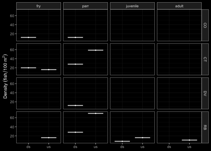
Figure 5.1: Densites of fish (fish/100m2) captured upstream of PSCIS crossing 197379.
my_photo1 = fpr::fpr_photo_pull_by_str(str_to_pull = '_d1_')

my_caption1 = paste0('Typical habitat downstream of PSCIS crossing ', my_site, '.')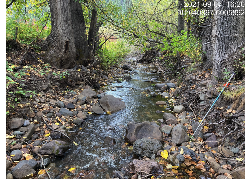
Figure 5.2: Typical habitat downstream of PSCIS crossing 197379.
my_photo2 = fpr::fpr_photo_pull_by_str(str_to_pull = '_d2_')

my_caption2 = paste0('Typical habitat downstream of PSCIS crossing ', my_site, '.')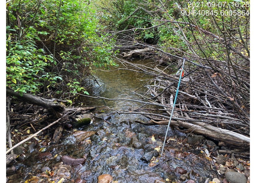
Figure 5.3: Typical habitat downstream of PSCIS crossing 197379.
my_caption <- paste0('Left: ', my_caption1, ' Right: ', my_caption2)

knitr::include_graphics(my_photo1)
knitr::include_graphics("fig/pixel.png")
knitr::include_graphics(my_photo2)
my_photo1 = fpr::fpr_photo_pull_by_str(str_to_pull = '_u1_')
my_caption1 = paste0('Typical habitat upstream of PSCIS crossing ', my_site, '.')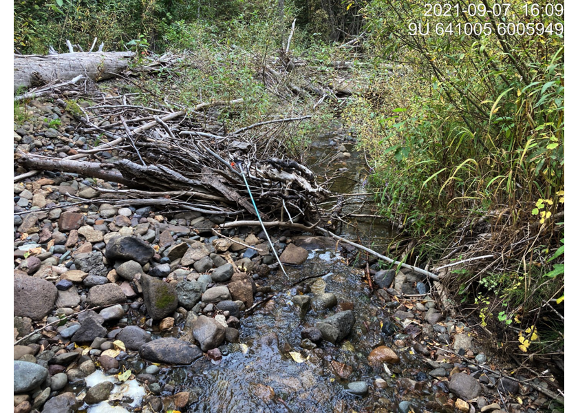
Figure 5.4: Typical habitat upstream of PSCIS crossing 197379.
my_photo2 = fpr::fpr_photo_pull_by_str(str_to_pull = '_u2_')

my_caption2 = paste0('Large woody debris jam upstream of PSCIS crossing ', my_site, '.')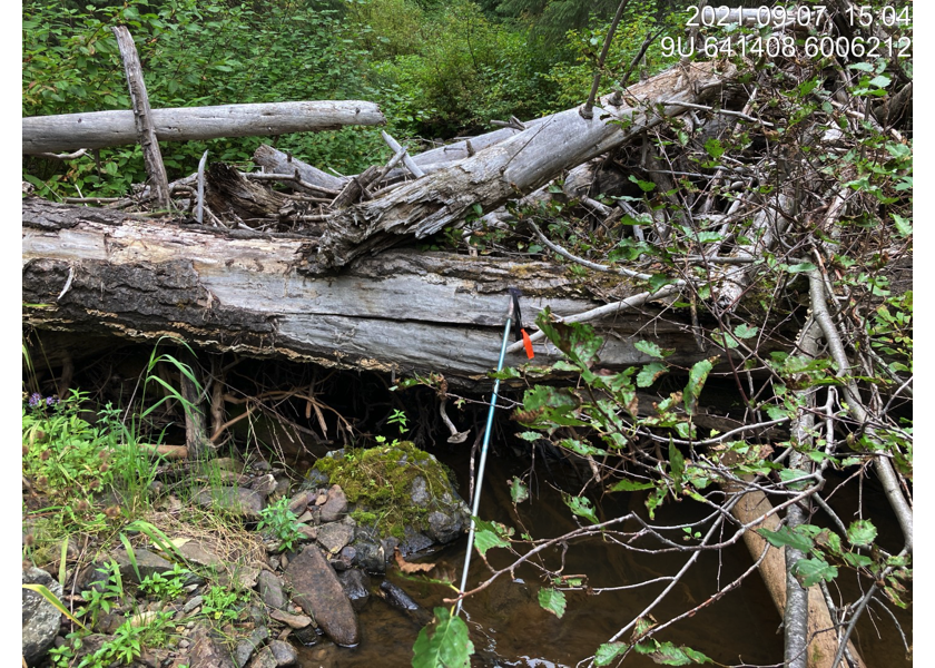
Figure 5.5: Large woody debris jam upstream of PSCIS crossing 197379.
my_caption <- paste0('Left: ', my_caption1, ' Right: ', my_caption2)

knitr::include_graphics(my_photo1)
knitr::include_graphics("fig/pixel.png")
knitr::include_graphics(my_photo2)
my_photo1 = fpr::fpr_photo_pull_by_str(str_to_pull = '_u3_')
my_caption1 = paste0('Typical habitat upstream of PSCIS crossing ', my_site, '.')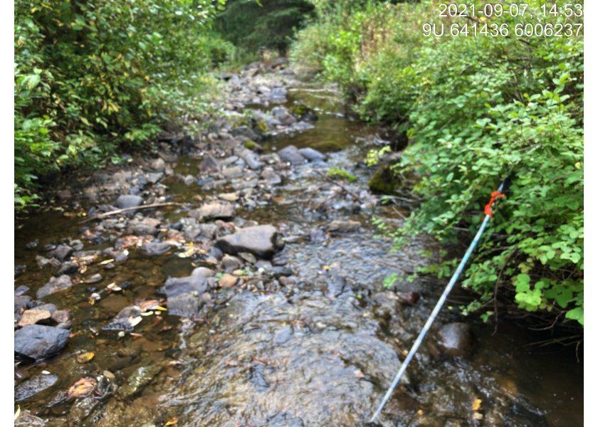
Figure 5.6: Typical habitat upstream of PSCIS crossing 197379.
my_photo2 = fpr::fpr_photo_pull_by_str(str_to_pull = '_u4_')

my_caption2 = paste0('Waterfall upstream of PSCIS crossing ', my_site, '.')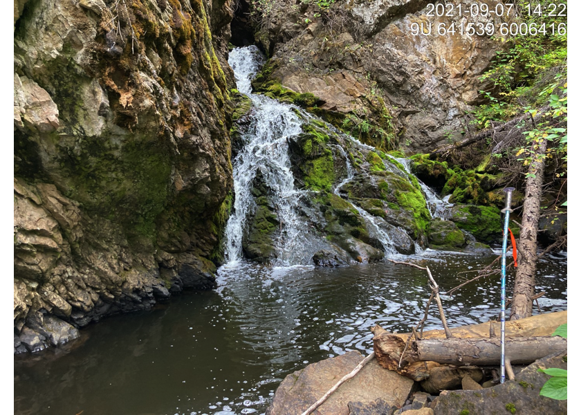
Figure 5.7: Waterfall upstream of PSCIS crossing 197379.
my_caption <- paste0('Left: ', my_caption1, ' Right: ', my_caption2)

knitr::include_graphics(my_photo1)
knitr::include_graphics("fig/pixel.png")
knitr::include_graphics(my_photo2)
my_photo1 = fpr::fpr_photo_pull_by_str(str_to_pull = '_ef1_')
my_caption1 = paste0('Coho captured downstream of PSCIS crossing ', my_site, '.')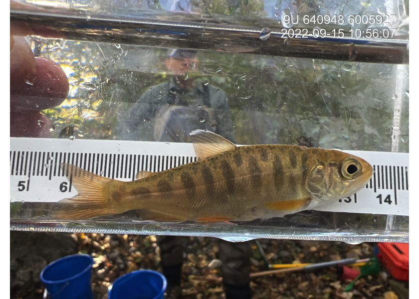
Figure 5.8: Coho captured downstream of PSCIS crossing 197379.
my_photo2 = fpr::fpr_photo_pull_by_str(str_to_pull = '_ef2_')

my_caption2 = paste0('Cutthroat trout captured upstream of PSCIS crossing ', my_site, '.')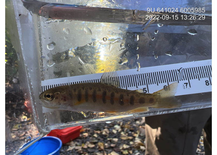
Figure 5.9: Cutthroat trout captured upstream of PSCIS crossing 197379.
my_caption <- paste0('Left: ', my_caption1, ' Right: ', my_caption2)

knitr::include_graphics(my_photo1)
knitr::include_graphics("fig/pixel.png")
knitr::include_graphics(my_photo2)