Pinenut Creek - 198222 - Appendix
Site Location
PSCIS crossing 198222 is located on Babine Slide FSR, on Pinenut Creek, approximately 15km north east of the small community of Glen Vowell, BC. Crossing 198222 was located on the east side of the Skeena River, approximately 0.6km upstream from the confluence.
Background
At crossing 198222, Pinenut Creek is a third order stream with a watershed area upstream of the crossing of approximately 21.5km2. The elevation of the watershed ranges from a maximum of 1964m to 420m near the crossing (Table 5.32). At the time of reporting, there was no fisheries information available for the area upstream of crossing 198222(MoE 2020b; Norris 2022).
fpr::fpr_table_wshd_sum(site_id = my_site) %>%
  fpr::fpr_kable(caption_text = paste0('Summary of derived upstream watershed statistics for PSCIS crossing ', my_site, '.'),
           footnote_text = 'Elev P60 = Elevation at which 60% of the watershed area is above',
scroll = F)| Site | Area Km | Elev Site | Elev Min | Elev Max | Elev Median | Elev P60 | Aspect |
|---|---|---|---|---|---|---|---|
| 198222 | 21.5 | 277 | 420 | 1964 | 1077 | 1006 | SW |
| * Elev P60 = Elevation at which 60% of the watershed area is above |
PSCIS stream crossing 198222 was ranked as a high
priority for follow up by the Society for Ecosystem Restoration in Northern BC due to significant quantities of habitat
upstream modelled by bcfishpass as likely suitable for salmon rearing.
A summary of habitat modelling outputs is presented in Table
5.33 and a map of the watershed is
provided in map attachment
093M.106.
| Habitat | Potential | Remediation Gain | Remediation Gain (%) |
|---|---|---|---|
| ST Network (km) | 9.2 | 8.7 | 95 |
| ST Lake Reservoir (ha) | – | 0.0 | – |
| ST Wetland (ha) | – | 0.0 | – |
| ST Slopeclass03 Waterbodies (km) | 0.0 | 0.0 | – |
| ST Slopeclass03 (km) | 0.0 | 0.0 | – |
| ST Slopeclass05 (km) | 0.9 | 0.9 | 100 |
| ST Slopeclass08 (km) | 3.2 | 3.2 | 100 |
| ST Spawning (km) | 0.0 | 0.0 | – |
| ST Rearing (km) | 3.9 | 3.9 | 100 |
| CH Spawning (km) | 0.0 | 0.0 | – |
| CH Rearing (km) | 0.0 | 0.0 | – |
| CO Spawning (km) | 0.9 | 0.9 | 100 |
| CO Rearing (km) | 0.9 | 0.9 | 100 |
| CO Rearing (ha) | – | 0.0 | – |
| SK Spawning (km) | 0.0 | 0.0 | – |
| SK Rearing (km) | 0.0 | 0.0 | – |
| SK Rearing (ha) | – | 0.0 | – |
| * Model data is preliminary and subject to adjustments. |
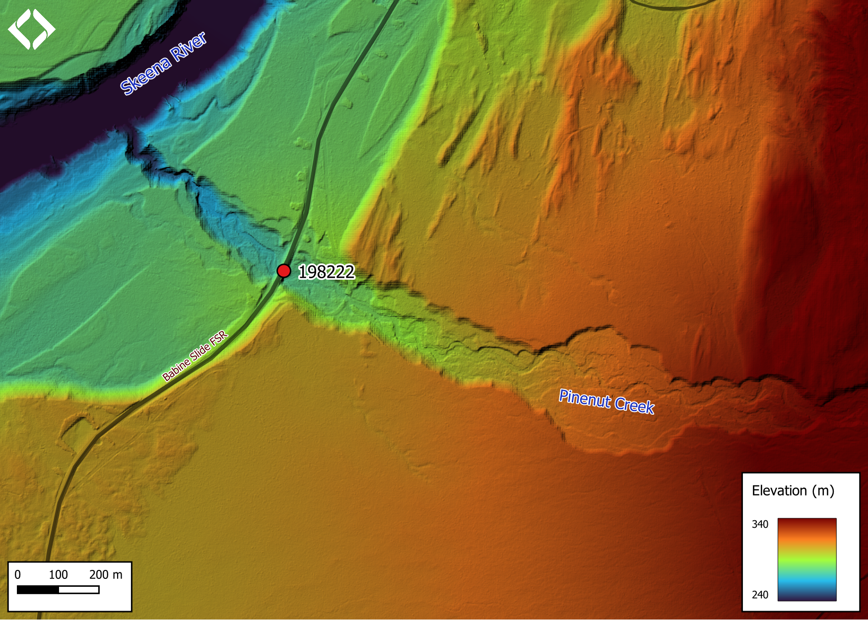
Figure 5.36: Lidar generated digital elevation model of Pinenut Creek at Babine Slide FSR (using elevation data from 2019).
Stream Characteristics at Crossing
At the time of the survey, PSCIS crossing 198222 was un-embedded, non-backwatered and ranked as a barrier to upstream fish passage according to the provincial protocol (MoE 2011b) (Table 5.34). This crossing was replaced in 1985. Water temperature was 9.7\(^\circ\)C, pH was 8.2 and conductivity was 75uS/cm.
| Location and Stream Data |
|
Crossing Characteristics | – |
|---|---|---|---|
| Date | 2022-09-08 | Crossing Sub Type | Round Culvert |
| PSCIS ID | 198222 | Diameter (m) | 3.8 |
| External ID | – | Length (m) | 30 |
| Crew | AI | Embedded | No |
| UTM Zone | 9 | Depth Embedded (m) | – |
| Easting | 587054 | Resemble Channel | No |
| Northing | 6138716 | Backwatered | No |
| Stream | Pinenut Creek | Percent Backwatered | – |
| Road | Babine Slide FSR | Fill Depth (m) | 4 |
| Road Tenure | MoF 4841 | Outlet Drop (m) | 0.45 |
| Channel Width (m) | 8.2 | Outlet Pool Depth (m) | 0.4 |
| Stream Slope (%) | 4 | Inlet Drop | No |
| Beaver Activity | No | Slope (%) | 2.5 |
| Habitat Value | High | Valley Fill | Deep Fill |
| Final score | 37 | Barrier Result | Barrier |
| Fix type | Replace with New Open Bottom Structure | Fix Span / Diameter | 15 |
Photos: From top left clockwise: Road/Site Card, Barrel, Outlet, Downstream, Upstream, Inlet.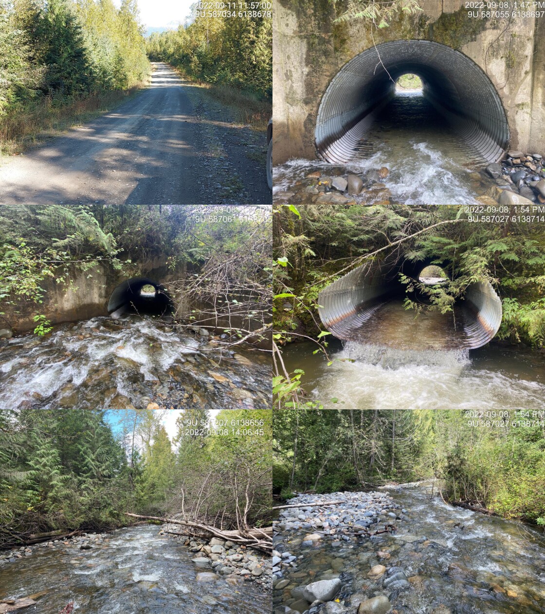
|
|||
| Comments: Structure was replaced in 1985. Concrete wing walls on inlet. Structure is in decent shape. 13:39 |
Stream Characteristics Downstream
The stream was surveyed downstream from crossing 198222 for 150m (Figures 5.37 - 5.38). The average channel width was 8.1m, the average wetted width was 5.4m, and the average gradient was 4.5%.Total cover amount was rated as trace with boulders dominant. Cover was also present as undercut banks.The dominant substrate was cobbles with gravels sub-dominant. The habitat was rated as medium value for salmonid rearing and spawning.
Stream Characteristics Upstream
The stream was surveyed upstream from crossing 198222 for 650m (Figures 5.39 - 5.42). The dominant substrate was cobbles with boulders sub-dominant.The average channel width was 13.1m, the average wetted width was 5.7m, and the average gradient was 3.6%.Total cover amount was rated as trace with boulders dominant. Cover was also present as undercut banks. There is a collapsed bridge approximately 200m from crossing 198222. Some erosion was present along the sides of the bridge but there was no fish passage issue at the time of survey. This was a high energy system with numerous areas of multiple channels, islands and elevated bars. High flows were pushing most of the large woody debris out of the main channel, resulting in lower complexity. There were rare pockets of gravel suitable for spawning. Overall, the habitat surveyed upstream of the crossing was rated as medium value as an important migration corridor containing habitat suitable for spawning and rearing.
Fish Sampling
To assess potential impacts of the culvert on fisheries values in the stream, minnowtrapping was conducted upstream and downstream of the crossing. Two traps were set downstream of the crossing and two were set upstream; traps were left overnight. 1 dolly varden was captured upstream and 6 dolly varden were captured downstream (Figures 5.43 - 5.44).
source('scripts/functions.R')
my_caption <- paste0('Fish captured in minnowtraps set overnight upstream and downstream of PSCIS crossing ', my_site, '.')

tab_fish_mt() %>%
fpr::fpr_kable(caption_text = my_caption, scroll = F)| Location | Species | parr | juvenile |
|---|---|---|---|
| Downstream | DV | 3 | 3 |
| Upstream | DV | 0 | 1 |
Structure Remediation and Cost Estimate
Should restoration/maintenance activities proceed, replacement of PSCIS crossing 198222 with a bridge (15m span) is recommended. The cost of the work is estimated at $450,000 for a cost benefit of 8.7 linear m/$1000 and 35.7 m2/$1000.
Conclusion
Modelling indicates there is 3.9km of habitat upstream of crossing 198222 suitable for steelhead rearing, with areas surveyed rated as medium value for rearing and spawning. Although minnnow trapping is not considered a robust sampling method to definitively determine species composition - results indicated only dolly varden presence immediately adjacent to the crossing. Besides the drop at the outlet, crossing 198222 was in good condition and backwatering of the pipe could be considered if cost of replacement precludes remdiation efforts. Overall the site was ranked as a high priority for proceeding to design for replacement.
tab_hab_summary %>%
  filter(Site  == my_site) %>%
  # select(-Site) %>%
  fpr::fpr_kable(caption_text = paste0('Summary of habitat details for PSCIS crossing ', my_site, '.'),
scroll = F) | Site | Location | Length Surveyed (m) | Channel Width (m) | Wetted Width (m) | Pool Depth (m) | Gradient (%) | Total Cover | Habitat Value |
|---|---|---|---|---|---|---|---|---|
| 198222 | Downstream | 150 | 8.1 | 5.4 | 0.5 | 4.5 | trace | medium |
| 198222 | Upstream | 650 | 13.1 | 5.7 | 0.4 | 3.6 | trace | medium |
my_photo1 = fpr::fpr_photo_pull_by_str(str_to_pull = '_d1_')

my_caption1 = paste0('Typical habitat downstream of PSCIS crossing ', my_site, '.')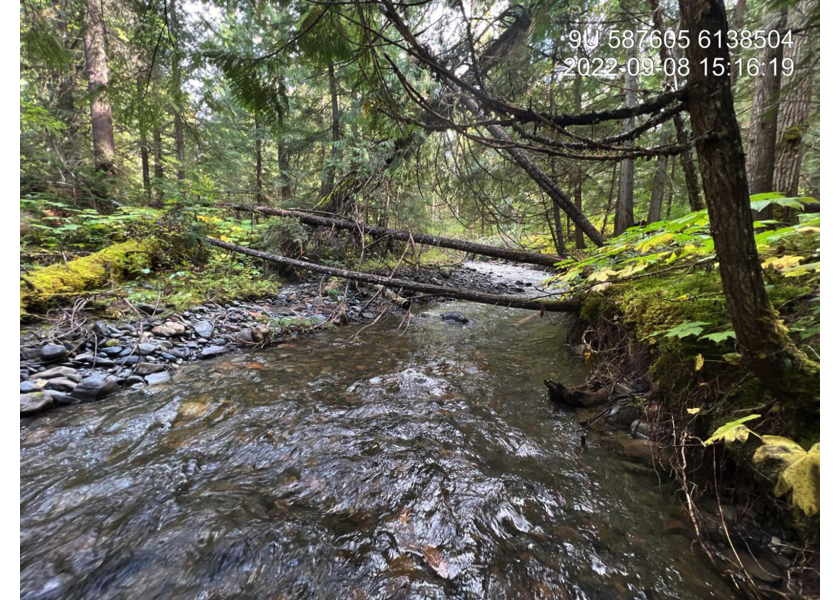
Figure 5.37: Typical habitat downstream of PSCIS crossing 198222.
my_photo2 = fpr::fpr_photo_pull_by_str(str_to_pull = '_d2_')

my_caption2 = paste0('Typical habitat downstream of PSCIS crossing ', my_site, '.')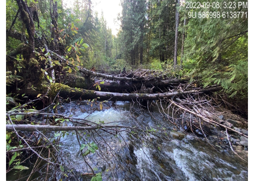
Figure 5.38: Typical habitat downstream of PSCIS crossing 198222.
my_caption <- paste0('Left: ', my_caption1, ' Right: ', my_caption2)

knitr::include_graphics(my_photo1)
knitr::include_graphics("fig/pixel.png")
knitr::include_graphics(my_photo2)
my_photo1 = fpr::fpr_photo_pull_by_str(str_to_pull = '_u1_')
my_caption1 = paste0('Typical habitat upstream of PSCIS crossing ', my_site, '.')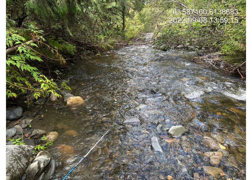
Figure 5.39: Typical habitat upstream of PSCIS crossing 198222.
my_photo2 = fpr::fpr_photo_pull_by_str(str_to_pull = '_u2_')

my_caption2 = paste0('Collapsed bridge upstream of PSCIS crossing ', my_site, '.')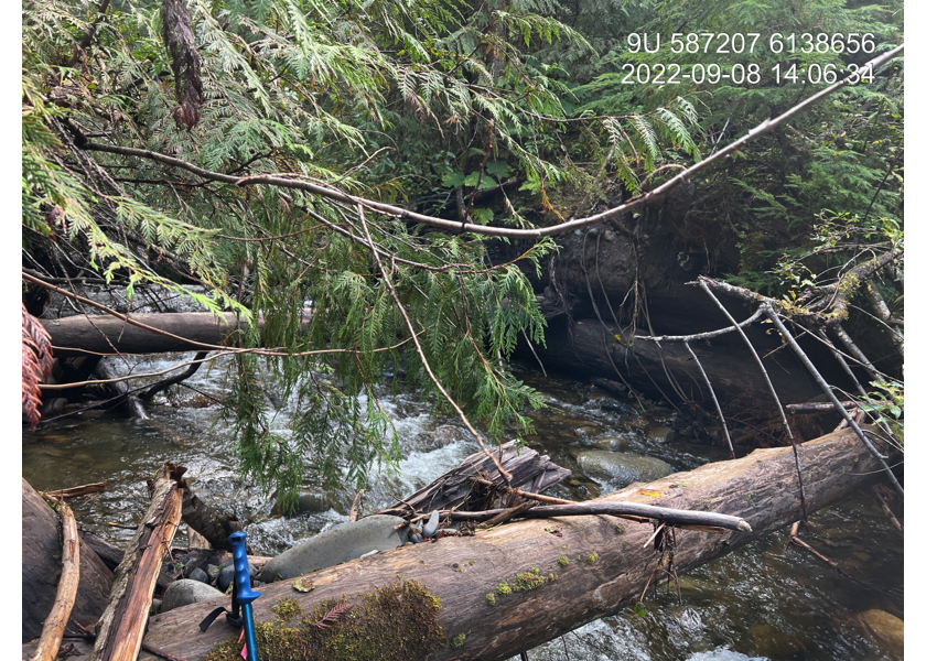
Figure 5.40: Collapsed bridge upstream of PSCIS crossing 198222.
my_caption <- paste0('Left: ', my_caption1, ' Right: ', my_caption2)

knitr::include_graphics(my_photo1)
knitr::include_graphics("fig/pixel.png")
knitr::include_graphics(my_photo2)
my_photo1 = fpr::fpr_photo_pull_by_str(str_to_pull = '_u3_')
my_caption1 = paste0('Typical habitat upstream of PSCIS crossing ', my_site, '.')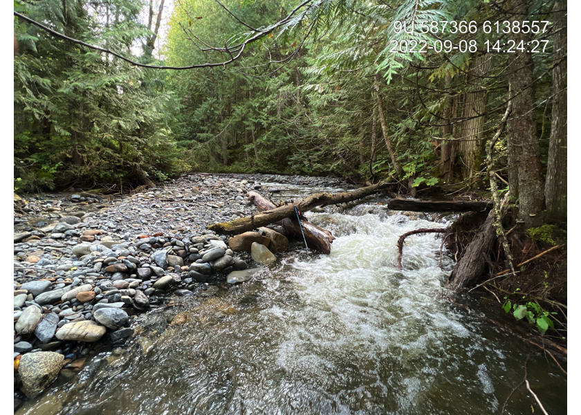
Figure 5.41: Typical habitat upstream of PSCIS crossing 198222.
my_photo2 = fpr::fpr_photo_pull_by_str(str_to_pull = '_u4_')

my_caption2 = paste0('Typical habitat upstream of PSCIS crossing ', my_site, '.')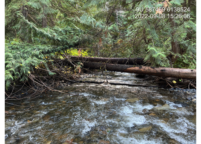
Figure 5.42: Typical habitat upstream of PSCIS crossing 198222.
my_caption <- paste0('Left: ', my_caption1, ' Right: ', my_caption2)

knitr::include_graphics(my_photo1)
knitr::include_graphics("fig/pixel.png")
knitr::include_graphics(my_photo2)
my_photo1 = fpr::fpr_photo_pull_by_str(str_to_pull = '_mt1_')
my_caption1 = paste0('Dolly Varden captured downstream of PSCIS crossing ', my_site, '.')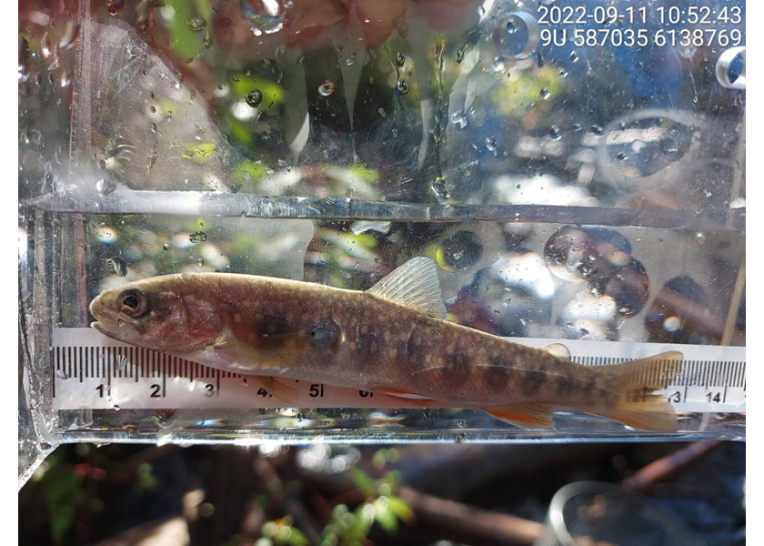
Figure 5.43: Dolly Varden captured downstream of PSCIS crossing 198222.
my_photo2 = fpr::fpr_photo_pull_by_str(str_to_pull = '_mt2_')

my_caption2 = paste0('Dolly Varden captured upstream of PSCIS crossing ', my_site, '.')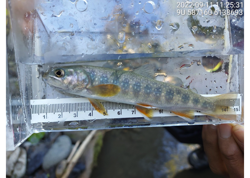
Figure 5.44: Dolly Varden captured upstream of PSCIS crossing 198222.
my_caption <- paste0('Left: ', my_caption1, ' Right: ', my_caption2)

knitr::include_graphics(my_photo1)
knitr::include_graphics("fig/pixel.png")
knitr::include_graphics(my_photo2)