Sandstone Creek - 8530 - Appendix
Site Location
PSCIS crossing 8530 is located on Sandstone Creek approximately 35km west of the town of Smithers, on Mcdonell FSR. This crossing is located approximately 650m upstream from the confluence with the Zymoetz River. This crossing is the responsibility of the Ministry of Forests.
Background
At crossing 8530, Sandstone Creek is a second order stream with a watershed area upstream of the crossing of approximately 14.2km2. The elevation of the watershed ranges from a maximum of 1282m to 814m at the crossing (Table 5.45). Upstream of crossing 8530, dolly varden, rainbow trout, and cutthroat trout have previously been recorded (MoE 2020b; Norris 2022). The mainstem of Sandstone Creek is 9.8km in length and is fed by 13 tributaries. Sandstone Lake is located approximately 4km upstream of crossing 8530, and has an area of 67ha. According to historical records, dolly varden and cutthroat trout have been known to reside in Sandstone Lake.
fpr::fpr_table_wshd_sum(site_id = my_site) %>%
  select(-'Elev Min') %>%
  fpr::fpr_kable(caption_text = paste0('Summary of derived upstream watershed statistics for PSCIS crossing ', my_site, '.'),
           footnote_text = 'Elev P60 = Elevation at which 60% of the watershed area is above',
scroll = F)| Site | Area Km | Elev Site | Elev Max | Elev Median | Elev P60 | Aspect |
|---|---|---|---|---|---|---|
| 8530 | 14.2 | 814 | 1282 | 1040 | 1029 | SSW |
| * Elev P60 = Elevation at which 60% of the watershed area is above |
Triton Environmental Consultants Ltd. (1998) conducted a reconnaissance level fish and fish habitat inventory on Sandstone Creek. In 1996, they conducted fish sampling at two sites located downstream of crossing 8530 and caught cutthroat trout. In 1997, Rainbow trout were caught by electrofishing upstream of Sandstone Lake and cutthroat trout were caught by electrofishing in a tributary located approximately 800m upstream of crossing 8530. At that time, Sandstone Creek was generally a low gradient stream with areas of moderate confinement. Upstream of Sandstone Lake, the stream flows for approximately 2.5km through an area of fisheries sensitive wetlands before draining a small unnamed lake.
PSCIS stream crossing 8530 was ranked as a high priority for follow up by the Society for Ecosystem Restoration in Northern BC because of significant amounts of habitat modelled upstream of the crossing. Viveiros (2011) assessed crossing 8530 in 2010. At the time of survey, it was recommended that the material in the pipe be embedded to reduce water velocity. A summary of habitat modelling outputs is presented in Table 5.46. A map of the watershed is provided in map attachment 093L.121.
| Habitat | Potential | Remediation Gain | Remediation Gain (%) |
|---|---|---|---|
| ST Network (km) | 2.6 | 0.5 | 19 |
| ST Lake Reservoir (ha) | 0.0 | 0.0 | – |
| ST Wetland (ha) | 0.0 | 0.0 | – |
| ST Slopeclass03 Waterbodies (km) | 0.0 | 0.0 | – |
| ST Slopeclass03 (km) | 1.5 | 0.0 | 0 |
| ST Slopeclass05 (km) | 0.1 | 0.0 | 0 |
| ST Slopeclass08 (km) | 1.0 | 0.5 | 50 |
| ST Spawning (km) | 0.0 | 0.0 | – |
| ST Rearing (km) | 0.0 | 0.0 | – |
| CH Spawning (km) | 0.0 | 0.0 | – |
| CH Rearing (km) | 0.0 | 0.0 | – |
| CO Spawning (km) | 0.4 | 0.0 | 0 |
| CO Rearing (km) | 0.4 | 0.0 | 0 |
| CO Rearing (ha) | 0.0 | 0.0 | – |
| SK Spawning (km) | 0.0 | 0.0 | – |
| SK Rearing (km) | 0.0 | 0.0 | – |
| SK Rearing (ha) | 0.0 | 0.0 | – |
| * Model data is preliminary and subject to adjustments. |
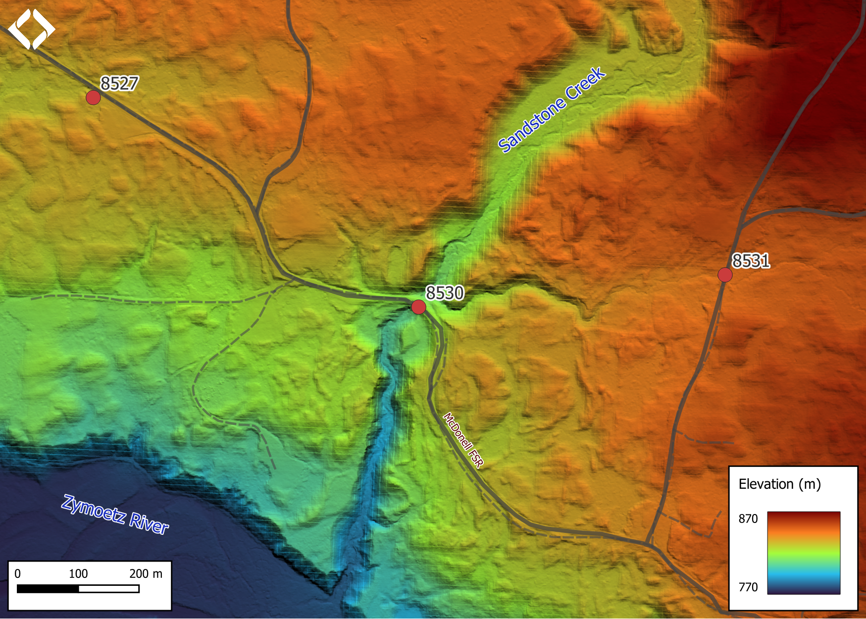
Figure 5.57: Lidar generated digital elevation model of Sandstone Creek at McDonell FSR (using elevation data from 2018).
Stream Characteristics at Crossing
At the time of the survey, PSCIS crossing 8530 was un-embedded, non-backwatered and ranked as a barrier to upstream fish passage according to the provincial protocol (MoE 2011b) (Table 5.47). Water temperature was 6.4\(^\circ\)C, pH was 7.4 and conductivity was 90uS/cm.
| Location and Stream Data |
|
Crossing Characteristics | – |
|---|---|---|---|
| Date | 2022-09-12 | Crossing Sub Type | Round Culvert |
| PSCIS ID | 8530 | Diameter (m) | 2.4 |
| External ID | – | Length (m) | 28 |
| Crew | MW | Embedded | No |
| UTM Zone | 9 | Depth Embedded (m) | – |
| Easting | 582704 | Resemble Channel | No |
| Northing | 6073877 | Backwatered | No |
| Stream | Sandstone Creek | Percent Backwatered | – |
| Road | Mcdonell FSR | Fill Depth (m) | 3 |
| Road Tenure | MoF 7552 | Outlet Drop (m) | 0.3 |
| Channel Width (m) | 3.4 | Outlet Pool Depth (m) | 0.2 |
| Stream Slope (%) | 3 | Inlet Drop | No |
| Beaver Activity | No | Slope (%) | 3 |
| Habitat Value | Medium | Valley Fill | Deep Fill |
| Final score | 39 | Barrier Result | Barrier |
| Fix type | Replace with New Open Bottom Structure | Fix Span / Diameter | 15 |
Photos: From top left clockwise: Road/Site Card, Barrel, Outlet, Downstream, Upstream, Inlet.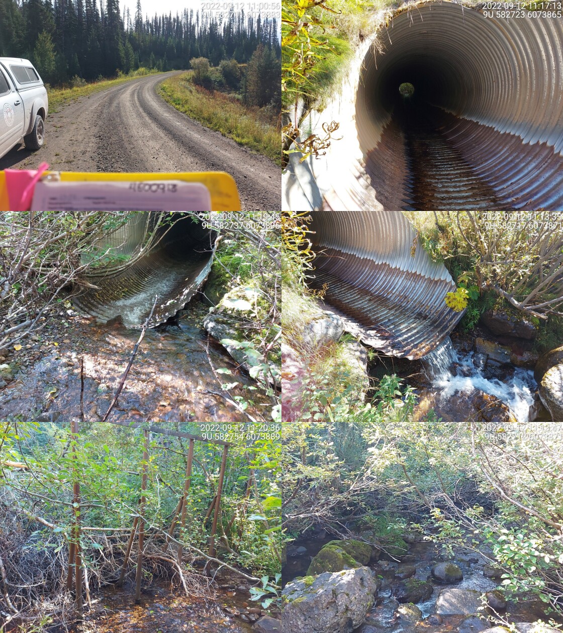
|
|||
| Comments: Channel is steeper downstream of culvert. Very deep fill with a small outlet drop. 10:59 |
Stream Characteristics Downstream
The stream was surveyed downstream from crossing 8530 for 275m (Figures 5.59 - 5.60). The average channel width was 4m, the average wetted width was 3.2m, and the average gradient was 2.8%.The dominant substrate was large rock/bedrock with cobbles sub-dominant.Total cover amount was rated as abundant with boulders dominant. Cover was also present as small woody debris, large woody debris, undercut banks, deep pools, and overhanging vegetation. There was good flow at the time of survey. Riparian vegetation was healthy, providing plenty of shade and cover. There were small packets of gravel suitable for spawning. Large woody debris jams and cascades were present that could act as a natural barrier to fish passage. However, during periods of high flow there’s a good chance that strong fish can traverse these barriers. Plenty of pools were available for fish rearing. There was abundant functional woody debris and boulders present that added complexity to the stream habitat. The stream was confined in a bed rock canyon, with overhanging vegetation and shrubs dominating the riparian zone. The habitat was rated as medium value for salmonid rearing and spawning.
Stream Characteristics Upstream
The stream was surveyed upstream from crossing 8530 for 600m (Figures 5.61 - 5.64). The average channel width was 3.8m, the average wetted width was 2.3m, and the average gradient was 3.2%.The dominant substrate was cobbles with gravels sub-dominant.Total cover amount was rated as moderate with small woody debris dominant. Cover was also present as large woody debris, undercut banks, and overhanging vegetation. There was abundant cover from woody debris, overhanging veg and undercut banks at the time of survey. The channel was wide throughout with graveled areas suitable for spawning. There was trace amounts of deep pools suitable for rearing. A couple smaller cascades (<1m in height) were present that may block the upstream migration of smaller fish. The habitat was rated as high value as an important migration corridor containing suitable spawning habitat and having moderate rearing potential.
Fish Sampling
Electrofishing was conducted with results summarised in Tables 5.49 - 5.50 and Figure 5.58. Dolly varden and cutthroat trout were caught both downstream and upstream of the culvert, while rainbow trout were only caught upstream (Figures 5.65 - 5.66). There was some uncertainty as to whether some fish were hybrids of rainbowe and ctthrout. Fish over 60mm in length were tagged with passive integrated transponders with tag ID and asssociated data located here.
Structure Remediation and Cost Estimate
Should restoration/maintenance activities proceed, replacement of PSCIS crossing 8530 with a bridge (15m span) is recommended. The cost of the work is estimated at $450,000 for a cost benefit of 12.7 linear m/$1000 and 21.5 m2/$1000.
Conclusion
There was 5.7km of habitat modelled upstream of crossing 8530 modelled as potential steelhead rearing habitat with areas surveyed rated as high value for salmonid rearing and spawning. Additionally, Sandstone Lake upstream provides habitat and flow moderating values to the sytem. Crossing 8530 was ranked as a high priority for proceeding to design for replacement. Sandstone Creek is a large system with habitat suitable for numerous species including cutthroat and dolly varden. Although habitat has modeled as suitable for steelhead and coho, presence of anadromous species was not confirmed through sampling. Nevertheless, replacement the crossing with a bridge would eliminate the outlet drop and reduce flow velocities at the road crossing.
tab_hab_summary %>%
  filter(Site  == my_site) %>%
  fpr::fpr_kable(caption_text = paste0('Summary of habitat details for PSCIS crossing ', my_site, '.'),
scroll = F) | Site | Location | Length Surveyed (m) | Channel Width (m) | Wetted Width (m) | Pool Depth (m) | Gradient (%) | Total Cover | Habitat Value |
|---|---|---|---|---|---|---|---|---|
| 8530 | Downstream | 275 | 4.0 | 3.2 | 0.4 | 2.8 | abundant | medium |
| 8530 | Upstream | 600 | 3.8 | 2.3 | 0.6 | 3.2 | moderate | high |
| site | passes | ef_length_m | ef_width_m | area_m2 | enclosure |
|---|---|---|---|---|---|
| 8530_ds_ef1 | 1 | 14 | 2.40 | 33.6 | Open |
| 8530_ds_ef2 | 1 | 15 | 3.33 | 50.0 | Open |
| 8530_ds_ef3 | 1 | 11 | 4.15 | 45.7 | Open |
| 8530_us_ef1 | 1 | 17 | 2.40 | 40.8 | Open |
| 8530_us_ef2 | 1 | 21 | 2.40 | 50.4 | Open |
| 8530_us_ef3 | 1 | 21 | 2.80 | 58.8 | Open |
| local_name | species_code | life_stage | catch | density_100m2 | nfc_pass |
|---|---|---|---|---|---|
| 8530_ds_ef1 | CT | fry | 6 | 17.9 | FALSE |
| 8530_ds_ef1 | CT | parr | 1 | 3.0 | FALSE |
| 8530_ds_ef2 | CT | fry | 2 | 4.0 | FALSE |
| 8530_ds_ef2 | CT | parr | 3 | 6.0 | FALSE |
| 8530_ds_ef2 | CT | juvenile | 1 | 2.0 | FALSE |
| 8530_ds_ef2 | CT | adult | 1 | 2.0 | FALSE |
| 8530_ds_ef2 | DV | parr | 1 | 2.0 | FALSE |
| 8530_ds_ef3 | CT | fry | 11 | 24.1 | FALSE |
| 8530_ds_ef3 | CT | parr | 2 | 4.4 | FALSE |
| 8530_ds_ef3 | DV | juvenile | 1 | 2.2 | FALSE |
| 8530_us_ef1 | CT | fry | 1 | 2.5 | FALSE |
| 8530_us_ef1 | CT | parr | 4 | 9.8 | FALSE |
| 8530_us_ef1 | CT | juvenile | 1 | 2.5 | FALSE |
| 8530_us_ef1 | RB | juvenile | 1 | 2.5 | FALSE |
| 8530_us_ef1 | TR | fry | 1 | 2.5 | FALSE |
| 8530_us_ef2 | CT | fry | 3 | 6.0 | FALSE |
| 8530_us_ef2 | CT | parr | 2 | 4.0 | FALSE |
| 8530_us_ef2 | CT | juvenile | 1 | 2.0 | FALSE |
| 8530_us_ef2 | DV | fry | 1 | 2.0 | FALSE |
| 8530_us_ef2 | DV | juvenile | 1 | 2.0 | FALSE |
| 8530_us_ef2 | RB | adult | 1 | 2.0 | FALSE |
| 8530_us_ef3 | CT | fry | 5 | 8.5 | FALSE |
| 8530_us_ef3 | CT | parr | 3 | 5.1 | FALSE |
| 8530_us_ef3 | CT | juvenile | 2 | 3.4 | FALSE |
| 8530_us_ef3 | CT | adult | 1 | 1.7 | FALSE |
| 8530_us_ef3 | DV | fry | 5 | 8.5 | FALSE |
| 8530_us_ef3 | DV | parr | 2 | 3.4 | FALSE |
|
* nfc_pass FALSE means fish were captured in final pass indicating more fish of this species/lifestage may have remained in site. Mark-recaptured required to reduce uncertainties. |
my_caption <- paste0('Densites of fish (fish/100m2) captured upstream of PSCIS crossing ', my_site, '.')

fpr_plot_fish_box() 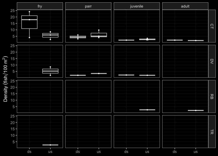
Figure 5.58: Densites of fish (fish/100m2) captured upstream of PSCIS crossing 8530.
my_photo1 = fpr::fpr_photo_pull_by_str(str_to_pull = '_d1_')

my_caption1 = paste0('Typical habitat downstream of PSCIS crossing ', my_site, '.')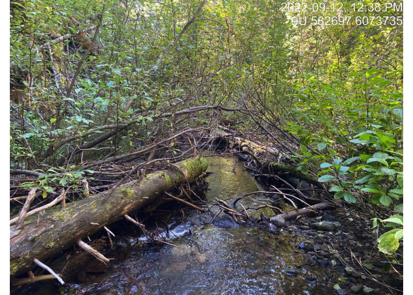
Figure 5.59: Typical habitat downstream of PSCIS crossing 8530.
my_photo2 = fpr::fpr_photo_pull_by_str(str_to_pull = '_d2_')

my_caption2 = paste0('Large woody debris jam downstream of PSCIS crossing ', my_site, '.')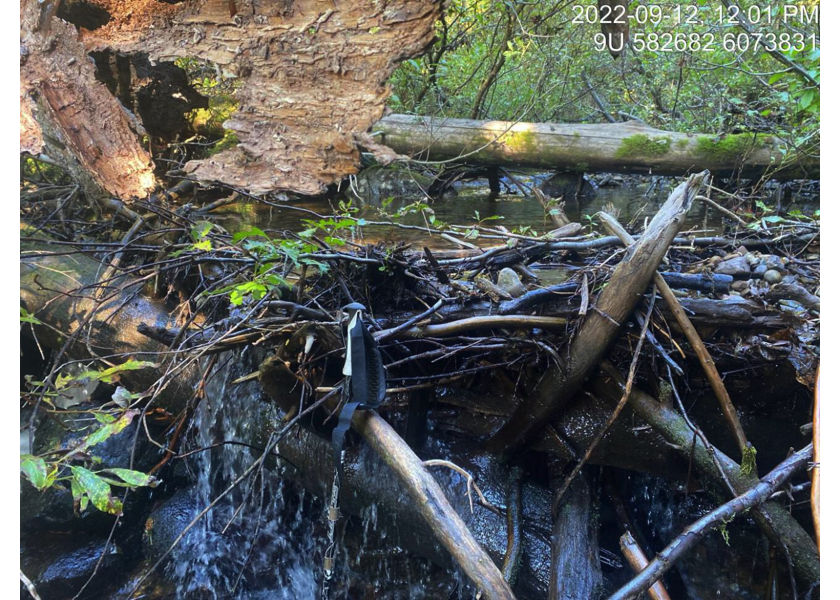
Figure 5.60: Large woody debris jam downstream of PSCIS crossing 8530.
my_caption <- paste0('Left: ', my_caption1, ' Right: ', my_caption2)

knitr::include_graphics(my_photo1)
knitr::include_graphics("fig/pixel.png")
knitr::include_graphics(my_photo2)
my_photo1 = fpr::fpr_photo_pull_by_str(str_to_pull = '_u1_')
my_caption1 = paste0('Typical habitat upstream of PSCIS crossing ', my_site, '.')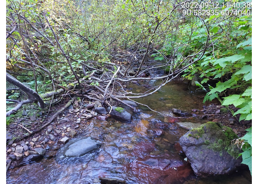
Figure 5.61: Typical habitat upstream of PSCIS crossing 8530.
my_photo2 = fpr::fpr_photo_pull_by_str(str_to_pull = '_u2_')

my_caption2 = paste0('Area with suitable spawning gravels, upstream of PSCIS crossing ', my_site, '.')
Figure 5.62: Area with suitable spawning gravels, upstream of PSCIS crossing 8530.
my_caption <- paste0('Left: ', my_caption1, ' Right: ', my_caption2)

knitr::include_graphics(my_photo1)
knitr::include_graphics("fig/pixel.png")
knitr::include_graphics(my_photo2)
my_photo1 = fpr::fpr_photo_pull_by_str(str_to_pull = '_u3_')
my_caption1 = paste0('Typical habitat upstream of PSCIS crossing ', my_site, '.')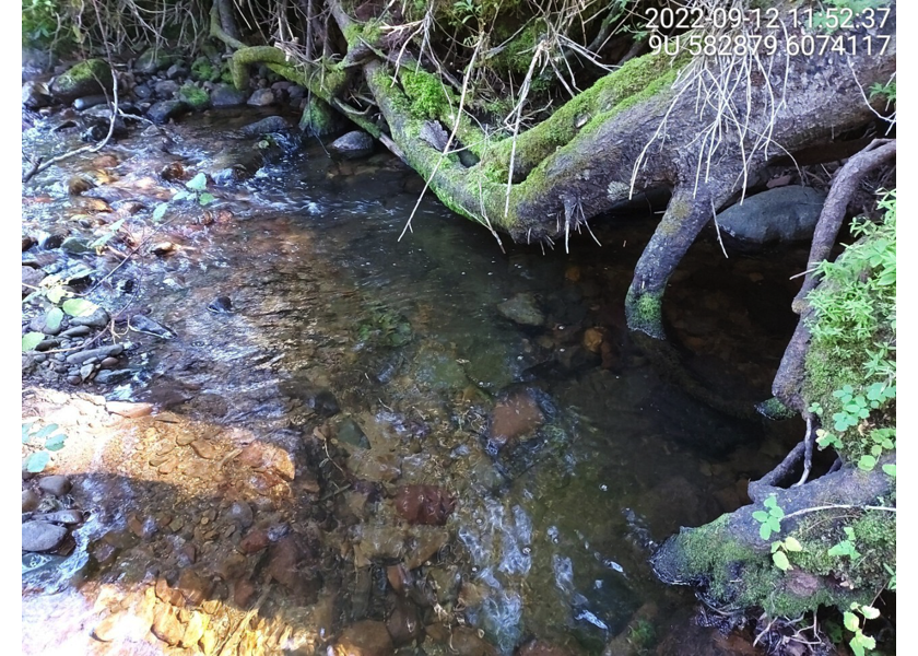
Figure 5.63: Typical habitat upstream of PSCIS crossing 8530.
my_photo2 = fpr::fpr_photo_pull_by_str(str_to_pull = '_u4_')

my_caption2 = paste0('Typical habitat upstream of PSCIS crossing ', my_site, '.')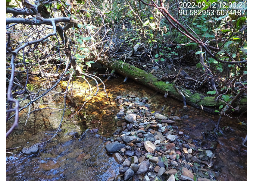
Figure 5.64: Typical habitat upstream of PSCIS crossing 8530.
my_caption <- paste0('Left: ', my_caption1, ' Right: ', my_caption2)

knitr::include_graphics(my_photo1)
knitr::include_graphics("fig/pixel.png")
knitr::include_graphics(my_photo2)
my_photo1 = fpr::fpr_photo_pull_by_str(str_to_pull = '_ef1_')
my_caption1 = paste0('Dolly Varden captured upstream of PSCIS crossing ', my_site, '.')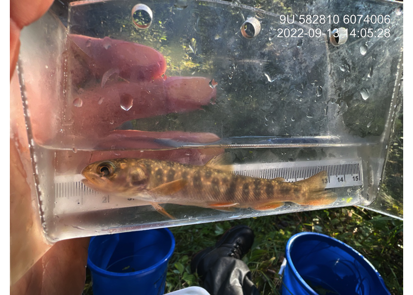
Figure 5.65: Dolly Varden captured upstream of PSCIS crossing 8530.
my_photo2 = fpr::fpr_photo_pull_by_str(str_to_pull = '_ef2_')

my_caption2 = paste0('Cutthroat trout captured downstream of PSCIS crossing ', my_site, '.')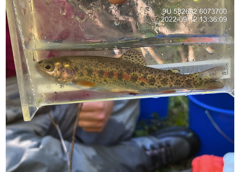
Figure 5.66: Cutthroat trout captured downstream of PSCIS crossing 8530.