Appendix - Phase 1 Fish Passage Assessment Data and Photos
| Location and Stream Data |
|
Crossing Characteristics | – |
|---|---|---|---|
| Date | 2022-09-05 | Crossing Sub Type | Ford |
| PSCIS ID | 198180 | Diameter (m) | – |
| External ID | 8301039 | Length (m) | – |
| Crew | MW | Embedded | – |
| UTM Zone | 9 | Depth Embedded (m) | – |
| Easting | 567730 | Resemble Channel | – |
| Northing | 6152762 | Backwatered | – |
| Stream | Tributary to Kispiox River | Percent Backwatered | – |
| Road | Helen 900 FSR | Fill Depth (m) | – |
| Road Tenure | BCTS 8243 | Outlet Drop (m) | – |
| Channel Width (m) | – | Outlet Pool Depth (m) | – |
| Stream Slope (%) | – | Inlet Drop | – |
| Beaver Activity | No | Slope (%) | – |
| Habitat Value | – | Valley Fill | – |
| Final score | 0 | Barrier Result | Unknown |
| Fix type | – | Fix Span / Diameter | – |
Photos: PSCIS ID 198180. From top left clockwise: Road/Site Card, Barrel, Outlet, Downstream, Upstream, Inlet.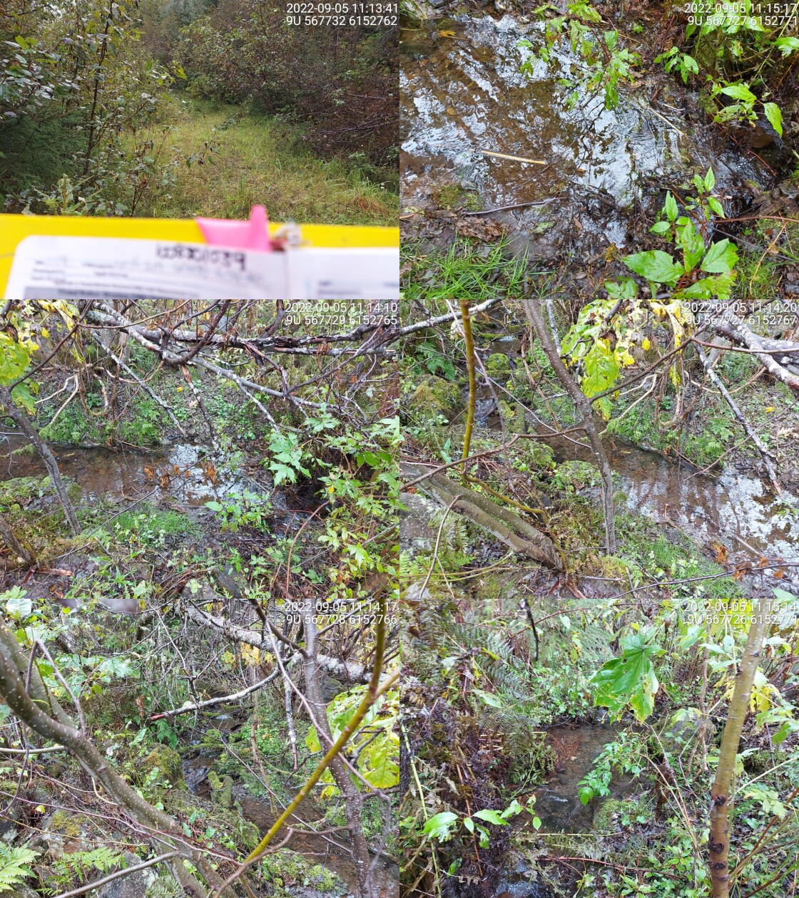
|
|||
| Comments: Small stream, good habitat with fines and gravely, and lots of cover and healthy riparian vegetation. 11:09 |
| Location and Stream Data |
|
Crossing Characteristics | – |
|---|---|---|---|
| Date | 2022-09-05 | Crossing Sub Type | Bridge |
| PSCIS ID | 198181 | Diameter (m) | 4 |
| External ID | 8302422 | Length (m) | 10 |
| Crew | MW | Embedded | – |
| UTM Zone | 9 | Depth Embedded (m) | – |
| Easting | 568047 | Resemble Channel | – |
| Northing | 6152961 | Backwatered | – |
| Stream | Tributary to Kispiox River | Percent Backwatered | – |
| Road | Helen 900 FSR | Fill Depth (m) | – |
| Road Tenure | BCTS 8243 | Outlet Drop (m) | – |
| Channel Width (m) | – | Outlet Pool Depth (m) | – |
| Stream Slope (%) | – | Inlet Drop | – |
| Beaver Activity | Yes | Slope (%) | – |
| Habitat Value | – | Valley Fill | – |
| Final score | 0 | Barrier Result | Passable |
| Fix type | – | Fix Span / Diameter | – |
Photos: PSCIS ID 198181. From top left clockwise: Road/Site Card, Barrel, Outlet, Downstream, Upstream, Inlet.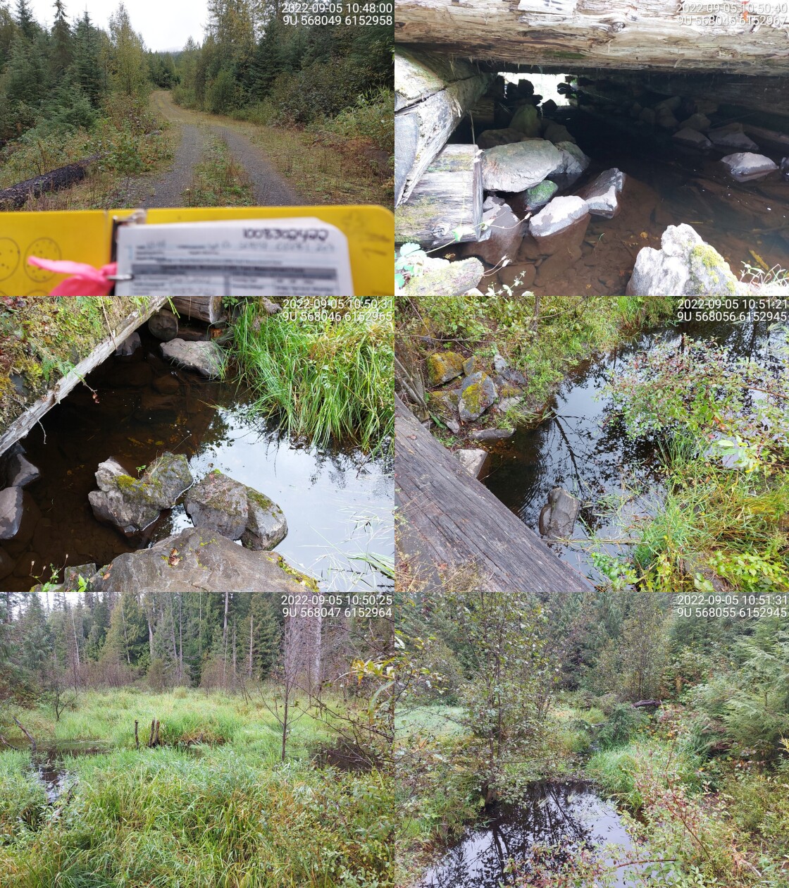
|
|||
| Comments: Wetland habitat on both sides, grassy and shrubs. Upstream has small cascade (0.5-1m high) draining into inlet pool. Bridge is in ok condition. 10:44 |
| Location and Stream Data |
|
Crossing Characteristics | – |
|---|---|---|---|
| Date | 2022-09-05 | Crossing Sub Type | Round Culvert |
| PSCIS ID | 198182 | Diameter (m) | 0.9 |
| External ID | 8302064 | Length (m) | 12 |
| Crew | MW | Embedded | No |
| UTM Zone | 9 | Depth Embedded (m) | – |
| Easting | 567986 | Resemble Channel | No |
| Northing | 6151778 | Backwatered | No |
| Stream | Tributary to Kispiox River | Percent Backwatered | – |
| Road | Helen Lake Rd | Fill Depth (m) | 1.5 |
| Road Tenure | BCTS 8243 | Outlet Drop (m) | 0 |
| Channel Width (m) | 1.4 | Outlet Pool Depth (m) | 0.1 |
| Stream Slope (%) | 1.5 | Inlet Drop | No |
| Beaver Activity | No | Slope (%) | 1 |
| Habitat Value | Medium | Valley Fill | Deep Fill |
| Final score | 21 | Barrier Result | Barrier |
| Fix type | Replace Structure with Streambed Simulation CBS | Fix Span / Diameter | 3 |
Photos: PSCIS ID 198182. From top left clockwise: Road/Site Card, Barrel, Outlet, Downstream, Upstream, Inlet.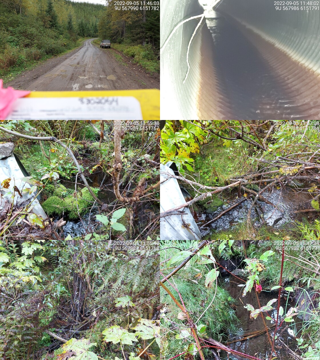
|
|||
| Comments: Good habitat with large amounts of cover (LWD and overhanging veg). Culvert is rusted and a little warped but in good condition, no outlet drop. 11:44 |
| Location and Stream Data |
|
Crossing Characteristics | – |
|---|---|---|---|
| Date | 2022-09-05 | Crossing Sub Type | Round Culvert |
| PSCIS ID | 198183 | Diameter (m) | 0.6 |
| External ID | 8302070 | Length (m) | 8 |
| Crew | MW | Embedded | No |
| UTM Zone | 9 | Depth Embedded (m) | – |
| Easting | 570210.4 | Resemble Channel | No |
| Northing | 6150340 | Backwatered | No |
| Stream | Tributary to Kispiox River | Percent Backwatered | – |
| Road | Helen Lake Rd | Fill Depth (m) | 3 |
| Road Tenure | BCTS 8243 | Outlet Drop (m) | 0.6 |
| Channel Width (m) | 2.3 | Outlet Pool Depth (m) | 0.7 |
| Stream Slope (%) | 1 | Inlet Drop | Yes |
| Beaver Activity | No | Slope (%) | 2 |
| Habitat Value | Medium | Valley Fill | Deep Fill |
| Final score | 31 | Barrier Result | Barrier |
| Fix type | Replace with New Open Bottom Structure | Fix Span / Diameter | 10 |
Photos: PSCIS ID 198183. From top left clockwise: Road/Site Card, Barrel, Outlet, Downstream, Upstream, Inlet.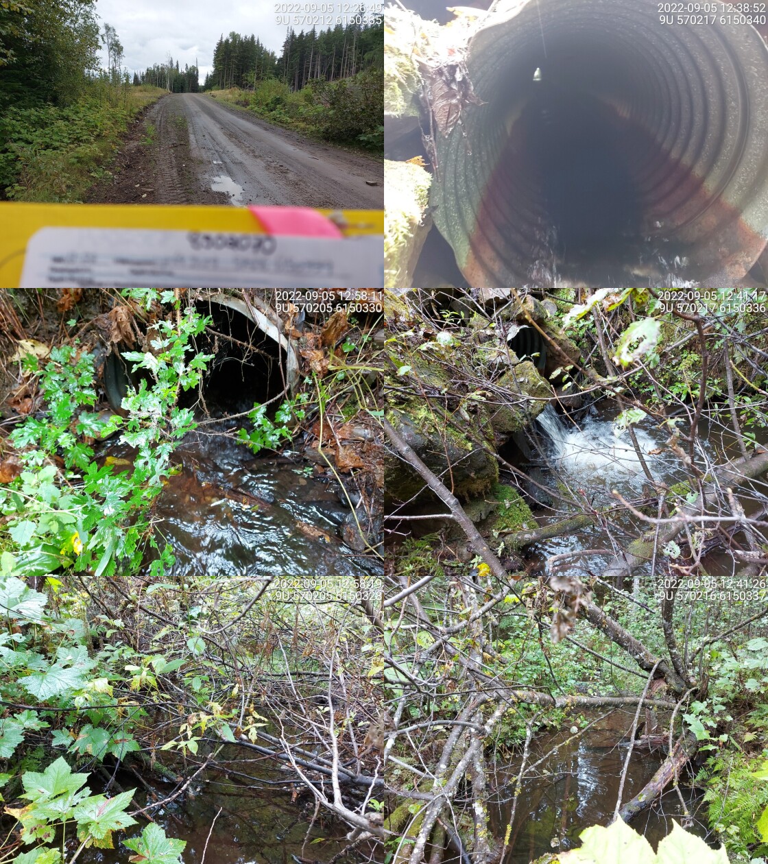
|
|||
| Comments: Big outlet drop with deep outlet pool. Some rusting in culvert and it’s bent slightly in the middle. 12:22 |
| Location and Stream Data |
|
Crossing Characteristics | – |
|---|---|---|---|
| Date | 2022-09-05 | Crossing Sub Type | Round Culvert |
| PSCIS ID | 198184 | Diameter (m) | 0.6 |
| External ID | 8302074 | Length (m) | 8 |
| Crew | MW | Embedded | No |
| UTM Zone | 9 | Depth Embedded (m) | – |
| Easting | 570565.8 | Resemble Channel | No |
| Northing | 6150060 | Backwatered | No |
| Stream | Tributary to Kispiox River | Percent Backwatered | – |
| Road | Helen Lake Rd | Fill Depth (m) | 0.7 |
| Road Tenure | BCTS 8243 | Outlet Drop (m) | 0.2 |
| Channel Width (m) | 1.1 | Outlet Pool Depth (m) | 0.1 |
| Stream Slope (%) | 1 | Inlet Drop | No |
| Beaver Activity | No | Slope (%) | 0.5 |
| Habitat Value | Low | Valley Fill | Deep Fill |
| Final score | 21 | Barrier Result | Barrier |
| Fix type | Replace Structure with Streambed Simulation CBS | Fix Span / Diameter | 3 |
Photos: PSCIS ID 198184. From top left clockwise: Road/Site Card, Barrel, Outlet, Downstream, Upstream, Inlet.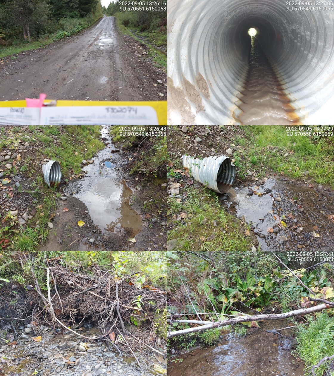
|
|||
| Comments: Very little flow, shallow stream around culvert. Large amounts of woody debris blocking stream near inlet. Lots of cover around stream. 13:23 |
| Location and Stream Data |
|
Crossing Characteristics | – |
|---|---|---|---|
| Date | 2022-09-05 | Crossing Sub Type | Round Culvert |
| PSCIS ID | 198185 | Diameter (m) | 0.7 |
| External ID | 8300115 | Length (m) | 11 |
| Crew | MW | Embedded | No |
| UTM Zone | 9 | Depth Embedded (m) | – |
| Easting | 574866.3 | Resemble Channel | No |
| Northing | 6149021 | Backwatered | No |
| Stream | Trib to McCully Creek | Percent Backwatered | – |
| Road | Helen Lake Rd | Fill Depth (m) | 0.3 |
| Road Tenure | MoTi Local | Outlet Drop (m) | 0 |
| Channel Width (m) | 1.3 | Outlet Pool Depth (m) | 0 |
| Stream Slope (%) | 1 | Inlet Drop | No |
| Beaver Activity | No | Slope (%) | 2 |
| Habitat Value | Low | Valley Fill | Deep Fill |
| Final score | 21 | Barrier Result | Barrier |
| Fix type | Replace Structure with Streambed Simulation CBS | Fix Span / Diameter | 3 |
Photos: PSCIS ID 198185. From top left clockwise: Road/Site Card, Barrel, Outlet, Downstream, Upstream, Inlet.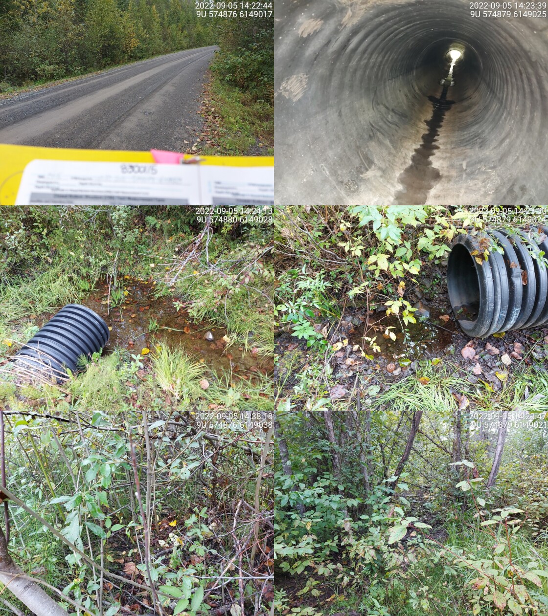
|
|||
| Comments: Culvert is black and plastic. 14:16 |
| Location and Stream Data |
|
Crossing Characteristics | – |
|---|---|---|---|
| Date | 2022-09-05 | Crossing Sub Type | Round Culvert |
| PSCIS ID | 198186 | Diameter (m) | 0.7 |
| External ID | 8300162 | Length (m) | 8 |
| Crew | MW | Embedded | No |
| UTM Zone | 9 | Depth Embedded (m) | – |
| Easting | 573033.2 | Resemble Channel | No |
| Northing | 6151997 | Backwatered | No |
| Stream | Tributary to Kispiox River | Percent Backwatered | – |
| Road | Poplar Park Rd | Fill Depth (m) | 0.5 |
| Road Tenure | MoTi Local | Outlet Drop (m) | 0 |
| Channel Width (m) | 1.2 | Outlet Pool Depth (m) | 0 |
| Stream Slope (%) | 1 | Inlet Drop | No |
| Beaver Activity | No | Slope (%) | 0 |
| Habitat Value | Low | Valley Fill | Deep Fill |
| Final score | 16 | Barrier Result | Potential |
| Fix type | Replace Structure with Streambed Simulation CBS | Fix Span / Diameter | 3 |
Photos: PSCIS ID 198186. From top left clockwise: Road/Site Card, Barrel, Outlet, Downstream, Upstream, Inlet.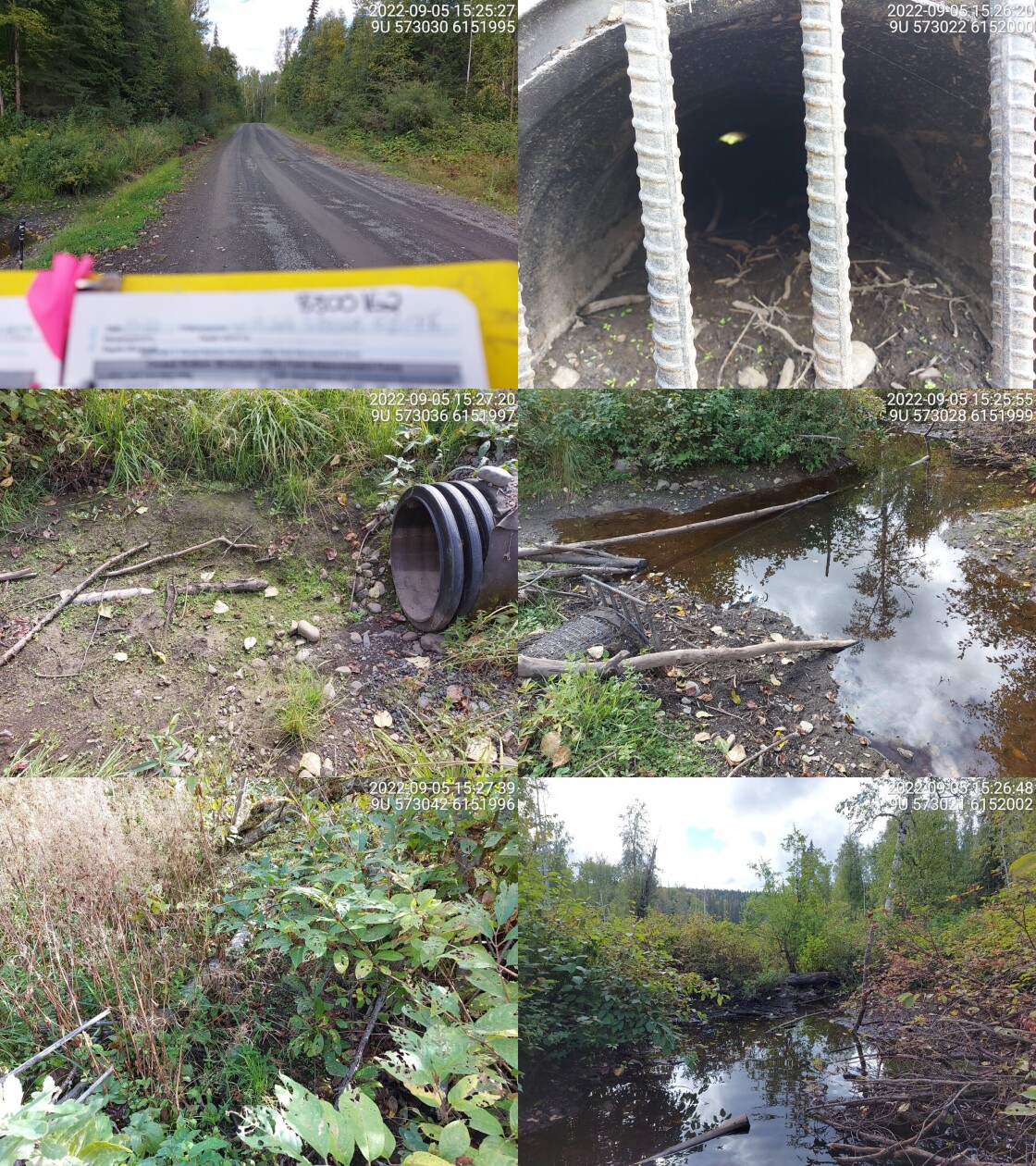
|
|||
| Comments: Drains Pentz Lake, mostly dewatered. Dawson may have replaced this crossing in fall of 2022 (pers comm Greg Black - project manager Dawson Road Maintenance). 15:22 |
| Location and Stream Data |
|
Crossing Characteristics | – |
|---|---|---|---|
| Date | 2022-09-05 | Crossing Sub Type | Round Culvert |
| PSCIS ID | 198187 | Diameter (m) | 0.4 |
| External ID | 2798180 | Length (m) | 9 |
| Crew | MW | Embedded | No |
| UTM Zone | 9 | Depth Embedded (m) | – |
| Easting | 573036 | Resemble Channel | No |
| Northing | 6151831 | Backwatered | Yes |
| Stream | Tributary to Kispiox River | Percent Backwatered | 50 |
| Road | Poplar Park Rd | Fill Depth (m) | 0.3 |
| Road Tenure | MoTi Local | Outlet Drop (m) | 0 |
| Channel Width (m) | 2.1 | Outlet Pool Depth (m) | 0 |
| Stream Slope (%) | 1 | Inlet Drop | No |
| Beaver Activity | No | Slope (%) | 1 |
| Habitat Value | Low | Valley Fill | Deep Fill |
| Final score | 21 | Barrier Result | Barrier |
| Fix type | Replace with New Open Bottom Structure | Fix Span / Diameter | 10 |
Photos: PSCIS ID 198187. From top left clockwise: Road/Site Card, Barrel, Outlet, Downstream, Upstream, Inlet.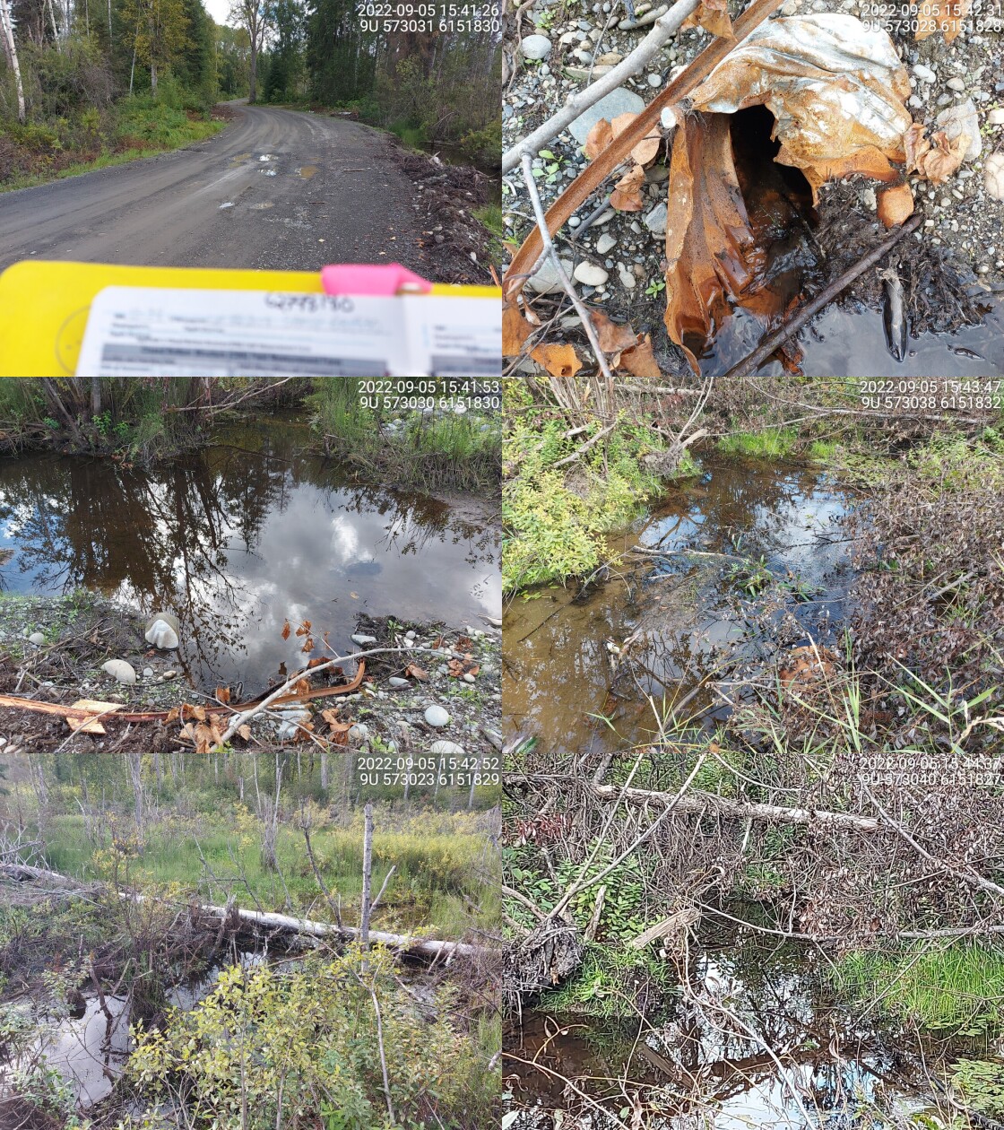
|
|||
| Comments: Drains Pentz Lake. Not a modelled crossing. Some backwater, not a lot of flow. Dawson may have replaced this crossing in fall of 2022 (pers comm Greg Black - project manager Dawson Road Maintenance). 15:39 |
| Location and Stream Data |
|
Crossing Characteristics | – |
|---|---|---|---|
| Date | 2022-09-05 | Crossing Sub Type | Round Culvert |
| PSCIS ID | 198188 | Diameter (m) | 1.1 |
| External ID | 8300161 | Length (m) | 11 |
| Crew | MW | Embedded | No |
| UTM Zone | 9 | Depth Embedded (m) | – |
| Easting | 575069.5 | Resemble Channel | No |
| Northing | 6150345 | Backwatered | No |
| Stream | Tributary to Kispiox River | Percent Backwatered | – |
| Road | Poplar Park Rd | Fill Depth (m) | 2.5 |
| Road Tenure | MoTi Local | Outlet Drop (m) | 0.2 |
| Channel Width (m) | 2.3 | Outlet Pool Depth (m) | 0.2 |
| Stream Slope (%) | 1.5 | Inlet Drop | Yes |
| Beaver Activity | Yes | Slope (%) | 2 |
| Habitat Value | Low | Valley Fill | Deep Fill |
| Final score | 26 | Barrier Result | Barrier |
| Fix type | Replace with New Open Bottom Structure | Fix Span / Diameter | 10 |
Photos: PSCIS ID 198188. From top left clockwise: Road/Site Card, Barrel, Outlet, Downstream, Upstream, Inlet.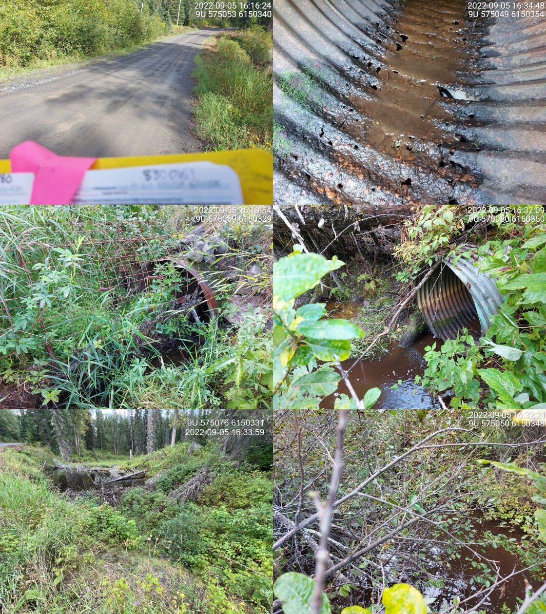
|
|||
| Comments: Big beaver dam right near inlet (about 2m in height). 16:12 |
| Location and Stream Data |
|
Crossing Characteristics | – |
|---|---|---|---|
| Date | 2022-09-06 | Crossing Sub Type | Ford |
| PSCIS ID | 198189 | Diameter (m) | – |
| External ID | 8300124 | Length (m) | – |
| Crew | MW AI | Embedded | – |
| UTM Zone | 9 | Depth Embedded (m) | – |
| Easting | 533805.9 | Resemble Channel | – |
| Northing | 6176387 | Backwatered | – |
| Stream | Tributary to Footsore Lake | Percent Backwatered | – |
| Road | Kispiox Valley Rd | Fill Depth (m) | – |
| Road Tenure | MoTi Local | Outlet Drop (m) | – |
| Channel Width (m) | – | Outlet Pool Depth (m) | – |
| Stream Slope (%) | – | Inlet Drop | – |
| Beaver Activity | No | Slope (%) | – |
| Habitat Value | – | Valley Fill | – |
| Final score | 0 | Barrier Result | Unknown |
| Fix type | – | Fix Span / Diameter | – |
Photos: PSCIS ID 198189. From top left clockwise: Road/Site Card, Barrel, Outlet, Downstream, Upstream, Inlet.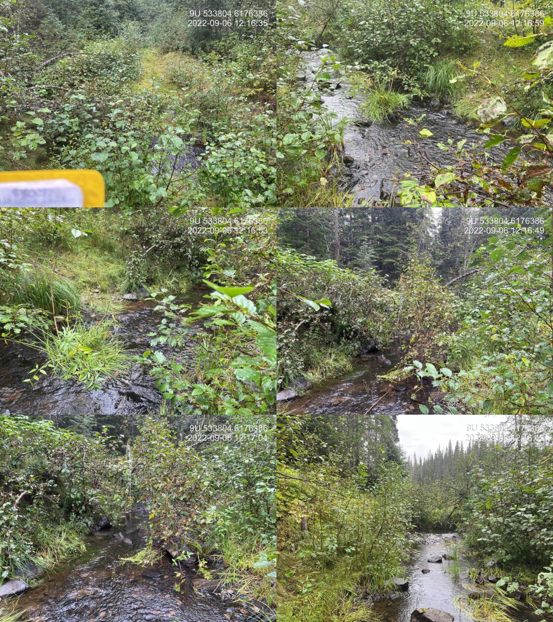
|
|||
| Comments: Road has been deactivated with crossing pulled. Lots of flow. 12:04 |
| Location and Stream Data |
|
Crossing Characteristics | – |
|---|---|---|---|
| Date | 2022-09-06 | Crossing Sub Type | Round Culvert |
| PSCIS ID | 198190 | Diameter (m) | 0.6 |
| External ID | 8302683 | Length (m) | 8 |
| Crew | MW | Embedded | No |
| UTM Zone | 9 | Depth Embedded (m) | – |
| Easting | 541972.9 | Resemble Channel | No |
| Northing | 6174712 | Backwatered | No |
| Stream | Sweetie River | Percent Backwatered | – |
| Road | Nangeese FSR | Fill Depth (m) | 1 |
| Road Tenure | BCTS 8904 | Outlet Drop (m) | 0 |
| Channel Width (m) | 1.9 | Outlet Pool Depth (m) | 0 |
| Stream Slope (%) | 2 | Inlet Drop | No |
| Beaver Activity | No | Slope (%) | 1 |
| Habitat Value | Low | Valley Fill | Deep Fill |
| Final score | 21 | Barrier Result | Barrier |
| Fix type | Replace Structure with Streambed Simulation CBS | Fix Span / Diameter | 3 |
Photos: PSCIS ID 198190. From top left clockwise: Road/Site Card, Barrel, Outlet, Downstream, Upstream, Inlet.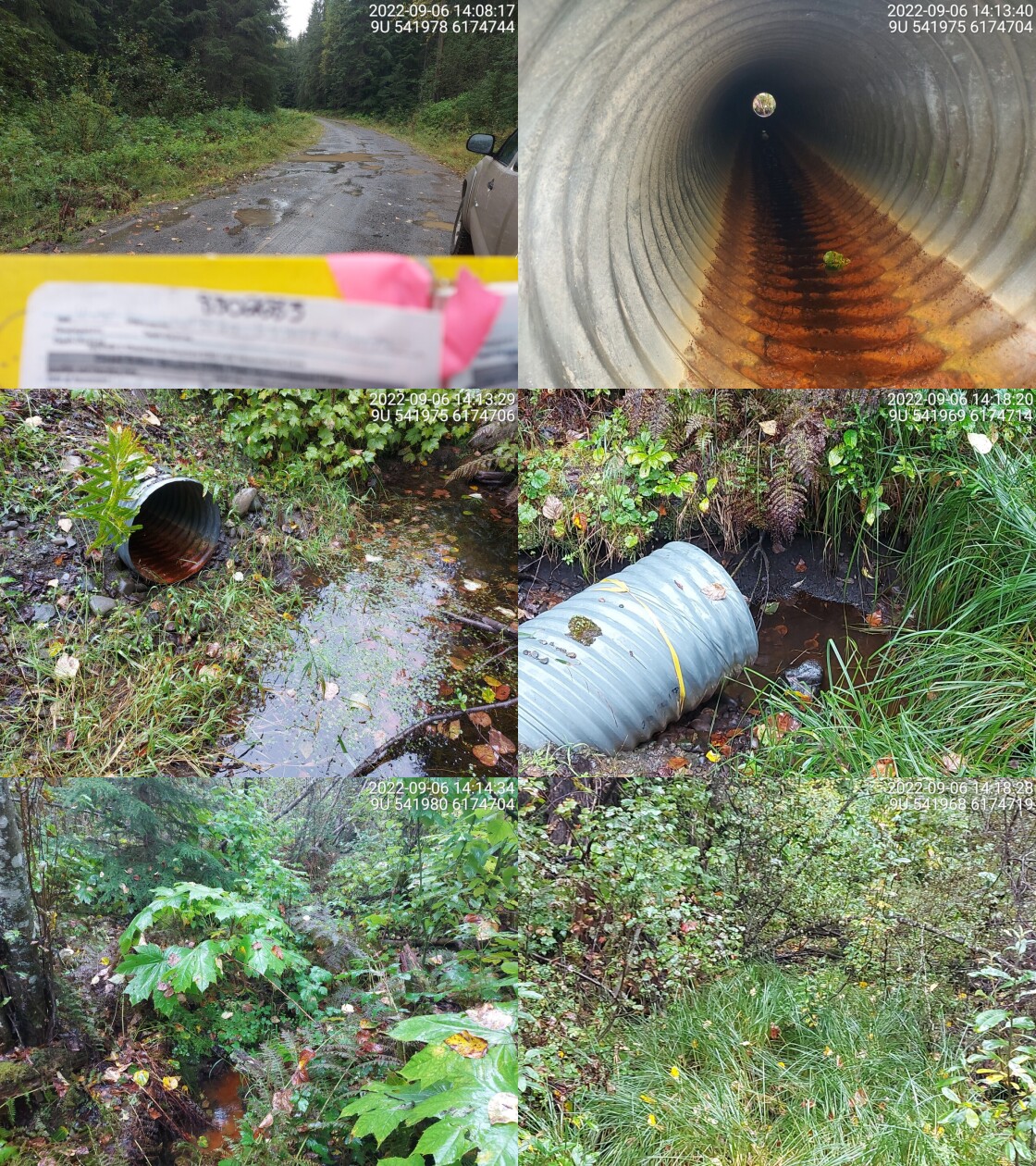
|
|||
| Comments: Stream is dewatered. Some rain water in pools. 14:05 |
| Location and Stream Data |
|
Crossing Characteristics | – |
|---|---|---|---|
| Date | 2022-09-06 | Crossing Sub Type | Round Culvert |
| PSCIS ID | 198191 | Diameter (m) | 0.5 |
| External ID | 8302061 | Length (m) | 13 |
| Crew | MW | Embedded | No |
| UTM Zone | 9 | Depth Embedded (m) | – |
| Easting | 554147.8 | Resemble Channel | No |
| Northing | 6166257 | Backwatered | No |
| Stream | Tributary to Kispiox River | Percent Backwatered | – |
| Road | Corral Main | Fill Depth (m) | 3 |
| Road Tenure | Gitxsan Forest R02415 | Outlet Drop (m) | 0.2 |
| Channel Width (m) | 1.5 | Outlet Pool Depth (m) | 0.15 |
| Stream Slope (%) | 4 | Inlet Drop | Yes |
| Beaver Activity | No | Slope (%) | 3 |
| Habitat Value | Medium | Valley Fill | Deep Fill |
| Final score | 31 | Barrier Result | Barrier |
| Fix type | Replace Structure with Streambed Simulation CBS | Fix Span / Diameter | 3 |
Photos: PSCIS ID 198191. From top left clockwise: Road/Site Card, Barrel, Outlet, Downstream, Upstream, Inlet.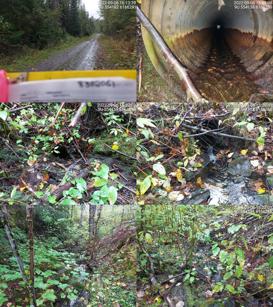
|
|||
| Comments: Small cascade approx 50m upstream, could be barrier for smaller fish. 16:10 |
| Location and Stream Data |
|
Crossing Characteristics | – |
|---|---|---|---|
| Date | 2022-09-06 | Crossing Sub Type | Round Culvert |
| PSCIS ID | 198192 | Diameter (m) | 0.6 |
| External ID | 8302062 | Length (m) | 12 |
| Crew | MW | Embedded | No |
| UTM Zone | 9 | Depth Embedded (m) | – |
| Easting | 554493.4 | Resemble Channel | No |
| Northing | 6166450 | Backwatered | No |
| Stream | Tributary to Kispiox River | Percent Backwatered | – |
| Road | Corral Main | Fill Depth (m) | 1 |
| Road Tenure | Gitxsan Forest R02415 | Outlet Drop (m) | 0.6 |
| Channel Width (m) | 1.9 | Outlet Pool Depth (m) | 0.3 |
| Stream Slope (%) | 2 | Inlet Drop | No |
| Beaver Activity | Yes | Slope (%) | 3 |
| Habitat Value | Low | Valley Fill | Deep Fill |
| Final score | 36 | Barrier Result | Barrier |
| Fix type | Replace Structure with Streambed Simulation CBS | Fix Span / Diameter | 3 |
Photos: PSCIS ID 198192. From top left clockwise: Road/Site Card, Barrel, Outlet, Downstream, Upstream, Inlet.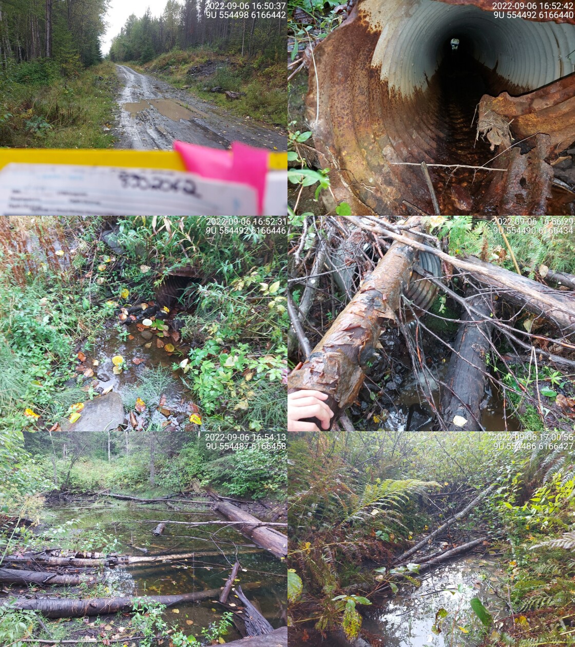
|
|||
| Comments: Big beaver dam upstream of culvert with big pond. Huge outlet drop. 16:49 |
| Location and Stream Data |
|
Crossing Characteristics | – |
|---|---|---|---|
| Date | 2022-09-07 | Crossing Sub Type | Round Culvert |
| PSCIS ID | 198193 | Diameter (m) | 1.2 |
| External ID | 8301747 | Length (m) | 13 |
| Crew | MW | Embedded | No |
| UTM Zone | 9 | Depth Embedded (m) | – |
| Easting | 563272.9 | Resemble Channel | No |
| Northing | 6170770 | Backwatered | No |
| Stream | Tributary to Cullon Creek | Percent Backwatered | – |
| Road | Kuldo FSR | Fill Depth (m) | 5 |
| Road Tenure | MoF 7871 | Outlet Drop (m) | 0.7 |
| Channel Width (m) | 1.8 | Outlet Pool Depth (m) | 0.6 |
| Stream Slope (%) | 20 | Inlet Drop | No |
| Beaver Activity | Yes | Slope (%) | 3 |
| Habitat Value | Low | Valley Fill | Deep Fill |
| Final score | 36 | Barrier Result | Barrier |
| Fix type | Replace Structure with Streambed Simulation CBS | Fix Span / Diameter | 3 |
Photos: PSCIS ID 198193. From top left clockwise: Road/Site Card, Barrel, Outlet, Downstream, Upstream, Inlet.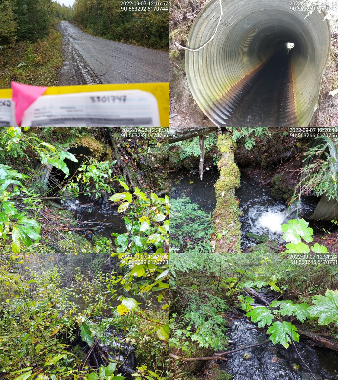
|
|||
| Comments: Signs of beaver activity just upstream of inlet. Big pond above dam. Very steep downstream of outlet, long cascade. 12:14 |
| Location and Stream Data |
|
Crossing Characteristics | – |
|---|---|---|---|
| Date | 2022-09-07 | Crossing Sub Type | Round Culvert |
| PSCIS ID | 198194 | Diameter (m) | 1.2 |
| External ID | 8301750 | Length (m) | 14 |
| Crew | MW | Embedded | No |
| UTM Zone | 9 | Depth Embedded (m) | – |
| Easting | 563429.4 | Resemble Channel | No |
| Northing | 6170437 | Backwatered | No |
| Stream | Tributary to Cullon Creek | Percent Backwatered | – |
| Road | Kuldo FSR | Fill Depth (m) | 2.5 |
| Road Tenure | MoF 7871 | Outlet Drop (m) | 0 |
| Channel Width (m) | 1.9 | Outlet Pool Depth (m) | 0.6 |
| Stream Slope (%) | 2.5 | Inlet Drop | Yes |
| Beaver Activity | No | Slope (%) | 1 |
| Habitat Value | Medium | Valley Fill | Deep Fill |
| Final score | 21 | Barrier Result | Barrier |
| Fix type | Replace Structure with Streambed Simulation CBS | Fix Span / Diameter | 3 |
Photos: PSCIS ID 198194. From top left clockwise: Road/Site Card, Barrel, Outlet, Downstream, Upstream, Inlet.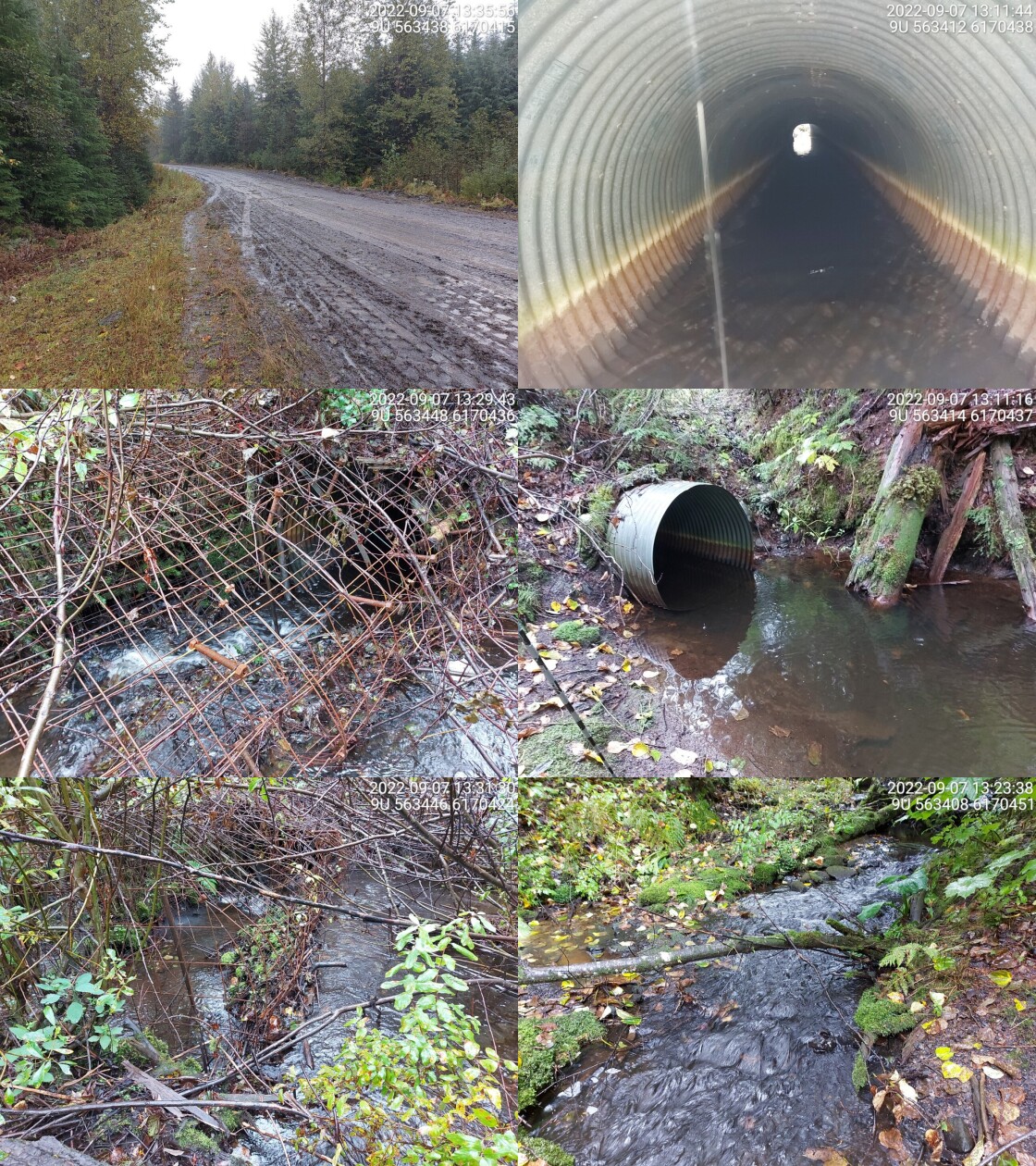
|
|||
| Comments: Big beaver guard on inlet. Blocking some of stream access from upstream. 13:02 |
| Location and Stream Data |
|
Crossing Characteristics | – |
|---|---|---|---|
| Date | 2022-09-07 | Crossing Sub Type | Round Culvert |
| PSCIS ID | 198195 | Diameter (m) | 0.65 |
| External ID | 8301761 | Length (m) | 10 |
| Crew | MW | Embedded | No |
| UTM Zone | 9 | Depth Embedded (m) | – |
| Easting | 563960.5 | Resemble Channel | No |
| Northing | 6165291 | Backwatered | No |
| Stream | Tributary to Cullon Creek | Percent Backwatered | – |
| Road | Kuldo FSR | Fill Depth (m) | 0.5 |
| Road Tenure | MoF 7871 | Outlet Drop (m) | 0.6 |
| Channel Width (m) | 1.5 | Outlet Pool Depth (m) | 0.2 |
| Stream Slope (%) | 10 | Inlet Drop | Yes |
| Beaver Activity | No | Slope (%) | 4 |
| Habitat Value | Low | Valley Fill | Deep Fill |
| Final score | 36 | Barrier Result | Barrier |
| Fix type | Replace Structure with Streambed Simulation CBS | Fix Span / Diameter | 3 |
Photos: PSCIS ID 198195. From top left clockwise: Road/Site Card, Barrel, Outlet, Downstream, Upstream, Inlet.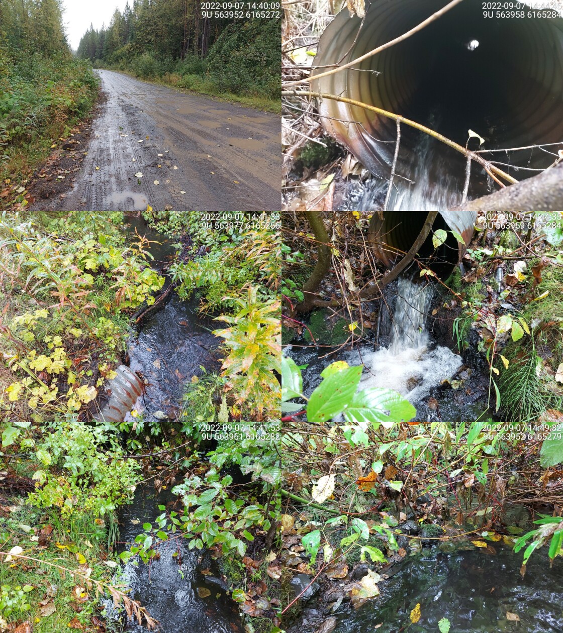
|
|||
| Comments: Waterfall directly downstream of outlet (2m in height). And short cascade upstream of inlet (approx 1m in height). 14:36 |
| Location and Stream Data |
|
Crossing Characteristics | – |
|---|---|---|---|
| Date | 2022-09-08 | Crossing Sub Type | Round Culvert |
| PSCIS ID | 198196 | Diameter (m) | 0.9 |
| External ID | 8300186 | Length (m) | 21 |
| Crew | MW | Embedded | No |
| UTM Zone | 9 | Depth Embedded (m) | – |
| Easting | 581810.5 | Resemble Channel | No |
| Northing | 6137778 | Backwatered | No |
| Stream | Tributary to Kispiox River | Percent Backwatered | – |
| Road | Kispiox Westside Rd | Fill Depth (m) | 1.5 |
| Road Tenure | MoTi Local | Outlet Drop (m) | 1.6 |
| Channel Width (m) | 2.4 | Outlet Pool Depth (m) | 0.1 |
| Stream Slope (%) | 12 | Inlet Drop | Yes |
| Beaver Activity | No | Slope (%) | 3.5 |
| Habitat Value | Low | Valley Fill | Deep Fill |
| Final score | 39 | Barrier Result | Barrier |
| Fix type | Replace with New Open Bottom Structure | Fix Span / Diameter | 10 |
Photos: PSCIS ID 198196. From top left clockwise: Road/Site Card, Barrel, Outlet, Downstream, Upstream, Inlet.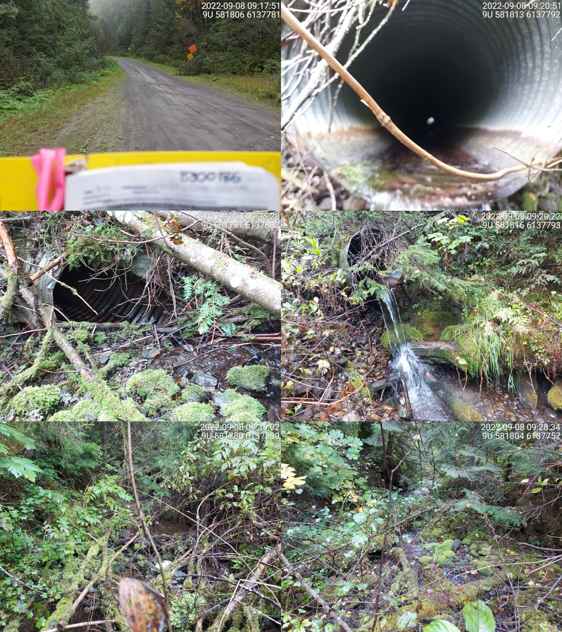
|
|||
| Comments: Very high outlet drop and steep stream downstream. But good habitat upstream with some fines and gravels and lots of cover. 9:13 |
| Location and Stream Data |
|
Crossing Characteristics | – |
|---|---|---|---|
| Date | 2022-09-08 | Crossing Sub Type | Round Culvert |
| PSCIS ID | 198197 | Diameter (m) | 0.9 |
| External ID | 8300105 | Length (m) | 8 |
| Crew | MW | Embedded | No |
| UTM Zone | 9 | Depth Embedded (m) | – |
| Easting | 578249.7 | Resemble Channel | No |
| Northing | 6150754 | Backwatered | No |
| Stream | Tributary to Kispiox River | Percent Backwatered | – |
| Road | Kispiox Valley Rd | Fill Depth (m) | 0.3 |
| Road Tenure | MoTi Local | Outlet Drop (m) | 0.6 |
| Channel Width (m) | 1.8 | Outlet Pool Depth (m) | 0.4 |
| Stream Slope (%) | 2 | Inlet Drop | No |
| Beaver Activity | No | Slope (%) | 1 |
| Habitat Value | Low | Valley Fill | Deep Fill |
| Final score | 31 | Barrier Result | Barrier |
| Fix type | Replace Structure with Streambed Simulation CBS | Fix Span / Diameter | 3 |
Photos: PSCIS ID 198197. From top left clockwise: Road/Site Card, Barrel, Outlet, Downstream, Upstream, Inlet.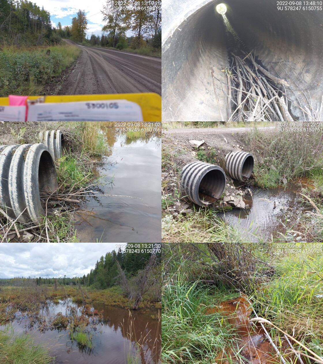
|
|||
| Comments: Two plastic culverts, very low flow in both. Open wetland and shrub habitat u/s and d/s. Big floodplain u/s. 13:16 |
| Location and Stream Data |
|
Crossing Characteristics | – |
|---|---|---|---|
| Date | 2022-09-08 | Crossing Sub Type | Round Culvert |
| PSCIS ID | 198198 | Diameter (m) | 0.8 |
| External ID | 8300104 | Length (m) | 15 |
| Crew | MW | Embedded | No |
| UTM Zone | 9 | Depth Embedded (m) | – |
| Easting | 579148.5 | Resemble Channel | No |
| Northing | 6149784 | Backwatered | Yes |
| Stream | Tributary to Kispiox River | Percent Backwatered | 100 |
| Road | Kispiox Valley Rd | Fill Depth (m) | 2 |
| Road Tenure | MoTi Local | Outlet Drop (m) | 0 |
| Channel Width (m) | 1.2 | Outlet Pool Depth (m) | 0.2 |
| Stream Slope (%) | 1 | Inlet Drop | No |
| Beaver Activity | No | Slope (%) | 0.5 |
| Habitat Value | Low | Valley Fill | Deep Fill |
| Final score | 19 | Barrier Result | Potential |
| Fix type | Replace Structure with Streambed Simulation CBS | Fix Span / Diameter | 3 |
Photos: PSCIS ID 198198. From top left clockwise: Road/Site Card, Barrel, Outlet, Downstream, Upstream, Inlet.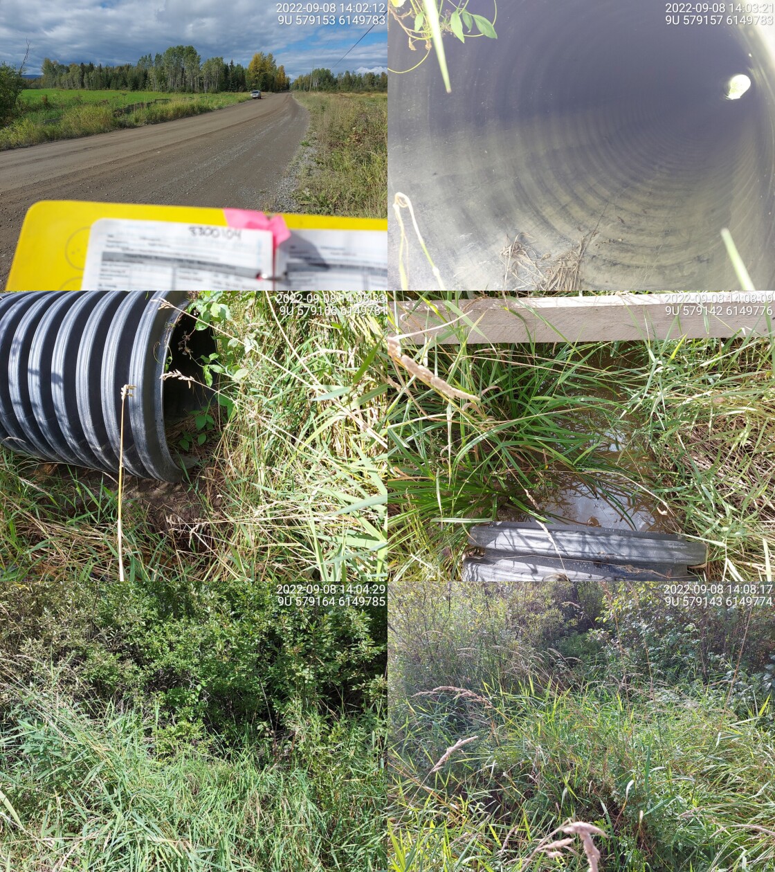
|
|||
| Comments: Plastic culvert. Backwatered with some water near the inlet and outlet but none in culvert. Large tributary to the Kispiox with major connectivity issue. No fisheries information but should be fish bearing and if not it would be due to the culvert. Dam points located 600 m upstream of crossing. 13:59 |
| Location and Stream Data |
|
Crossing Characteristics | – |
|---|---|---|---|
| Date | 2022-09-08 | Crossing Sub Type | Round Culvert |
| PSCIS ID | 198199 | Diameter (m) | 0.6 |
| External ID | 8300103 | Length (m) | 13 |
| Crew | MW | Embedded | No |
| UTM Zone | 9 | Depth Embedded (m) | – |
| Easting | 580494.9 | Resemble Channel | No |
| Northing | 6146061 | Backwatered | No |
| Stream | Tributary to Kispiox River | Percent Backwatered | – |
| Road | Kispiox Valley Rd | Fill Depth (m) | 2 |
| Road Tenure | MoTi Local | Outlet Drop (m) | 0 |
| Channel Width (m) | 1.4 | Outlet Pool Depth (m) | 0 |
| Stream Slope (%) | 2 | Inlet Drop | No |
| Beaver Activity | No | Slope (%) | 1 |
| Habitat Value | Low | Valley Fill | Deep Fill |
| Final score | 21 | Barrier Result | Barrier |
| Fix type | Replace Structure with Streambed Simulation CBS | Fix Span / Diameter | 3 |
Photos: PSCIS ID 198199. From top left clockwise: Road/Site Card, Barrel, Outlet, Downstream, Upstream, Inlet.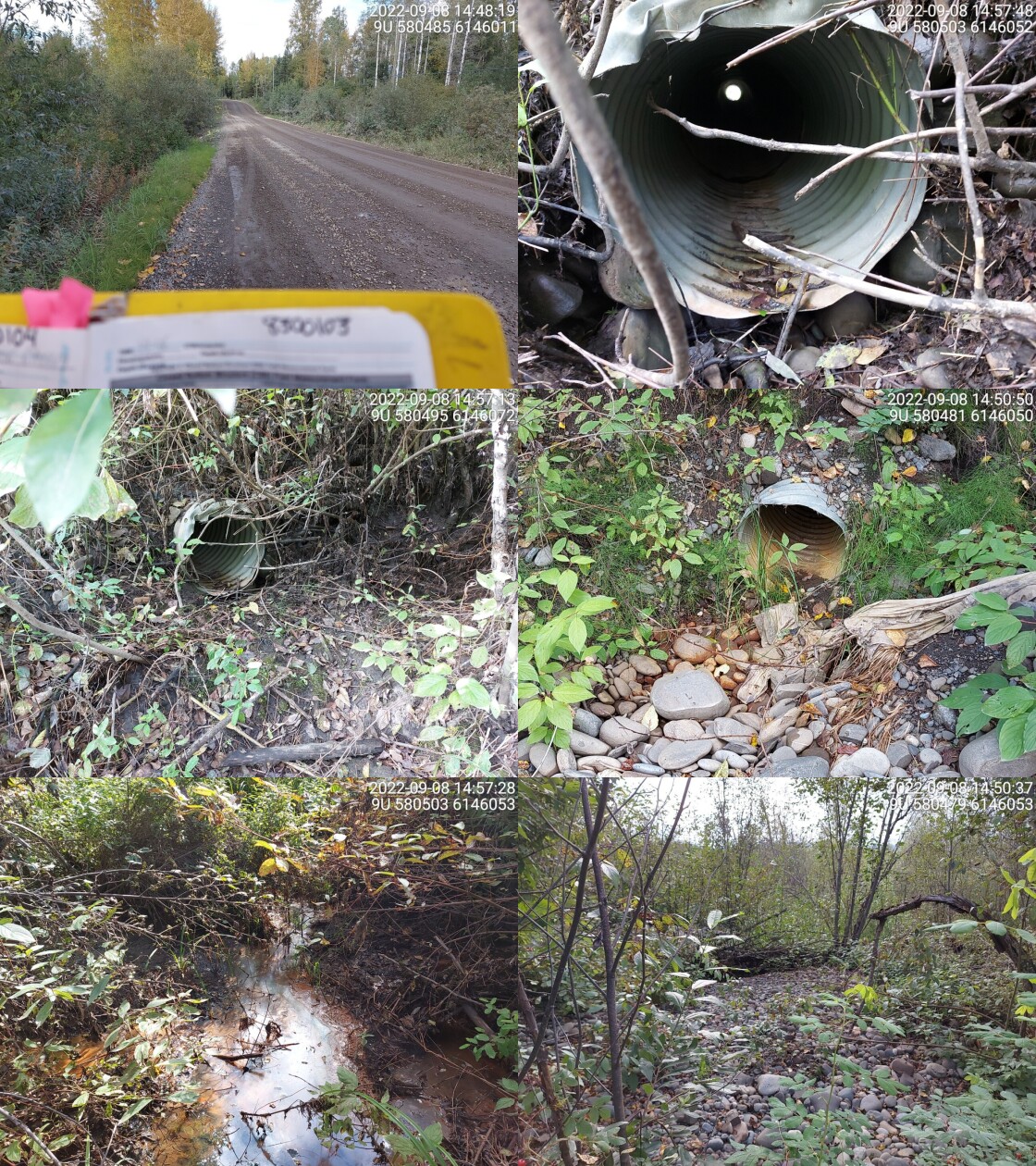
|
|||
| Comments: Dewatered stream. 14:46 |
| Location and Stream Data |
|
Crossing Characteristics | – |
|---|---|---|---|
| Date | 2022-09-09 | Crossing Sub Type | Round Culvert |
| PSCIS ID | 198200 | Diameter (m) | 2.8 |
| External ID | 8300012 | Length (m) | 10 |
| Crew | MW | Embedded | Yes |
| UTM Zone | 9 | Depth Embedded (m) | 0.22 |
| Easting | 563541.6 | Resemble Channel | Yes |
| Northing | 6109765 | Backwatered | No |
| Stream | Tributary to Kitwanga River | Percent Backwatered | – |
| Road | Moore Rd | Fill Depth (m) | 1 |
| Road Tenure | MoTi Local | Outlet Drop (m) | 0.1 |
| Channel Width (m) | 4.3 | Outlet Pool Depth (m) | 0.1 |
| Stream Slope (%) | 2 | Inlet Drop | No |
| Beaver Activity | No | Slope (%) | 0 |
| Habitat Value | High | Valley Fill | Deep Fill |
| Final score | 11 | Barrier Result | Passable |
| Fix type | – | Fix Span / Diameter | – |
Photos: PSCIS ID 198200. From top left clockwise: Road/Site Card, Barrel, Outlet, Downstream, Upstream, Inlet.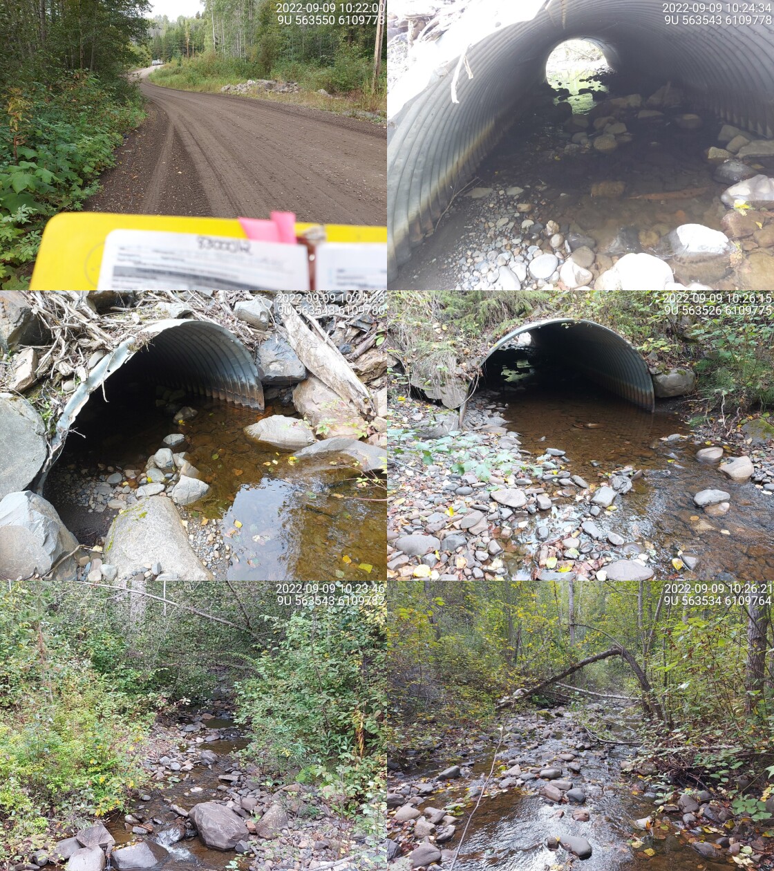
|
|||
| Comments: Embedded with no outlet drop. Very wide channel with gravels and cobbles. 10:18 |
| Location and Stream Data |
|
Crossing Characteristics | – |
|---|---|---|---|
| Date | 2022-09-09 | Crossing Sub Type | Round Culvert |
| PSCIS ID | 198201 | Diameter (m) | 1.6 |
| External ID | 8300917 | Length (m) | 8 |
| Crew | MW | Embedded | Yes |
| UTM Zone | 9 | Depth Embedded (m) | 0.38 |
| Easting | 563869.2 | Resemble Channel | Yes |
| Northing | 6109781 | Backwatered | No |
| Stream | Tributary to Kitwanga River | Percent Backwatered | – |
| Road | Moore Rd | Fill Depth (m) | 0.7 |
| Road Tenure | MoTi Unclassified | Outlet Drop (m) | 0 |
| Channel Width (m) | 2.1 | Outlet Pool Depth (m) | 0.2 |
| Stream Slope (%) | 1 | Inlet Drop | No |
| Beaver Activity | No | Slope (%) | 1.5 |
| Habitat Value | High | Valley Fill | Deep Fill |
| Final score | 11 | Barrier Result | Passable |
| Fix type | – | Fix Span / Diameter | – |
Photos: PSCIS ID 198201. From top left clockwise: Road/Site Card, Barrel, Outlet, Downstream, Upstream, Inlet.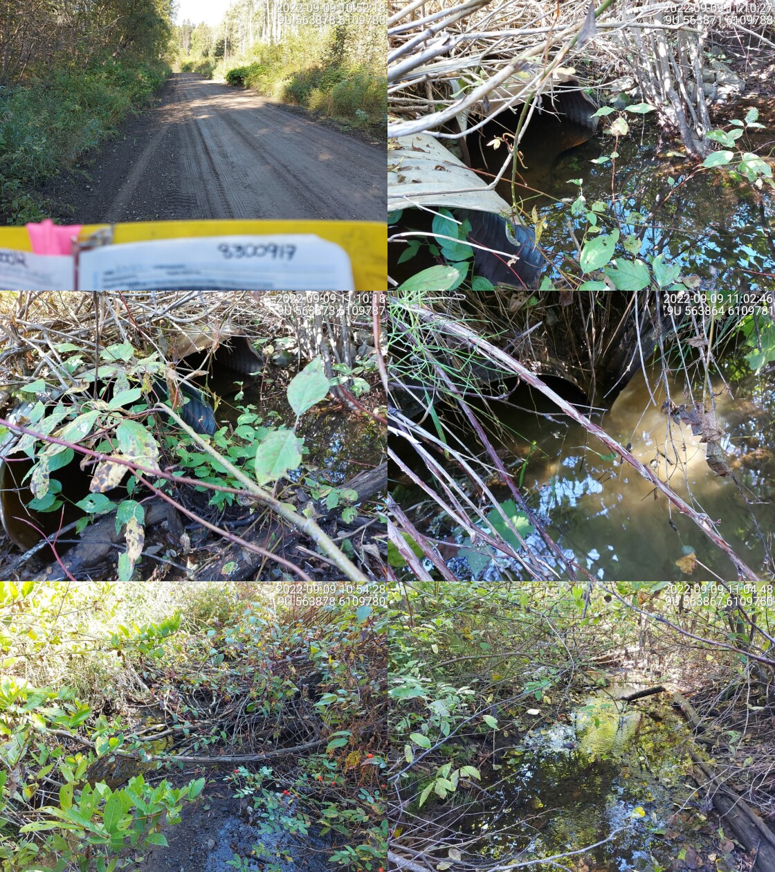
|
|||
| Comments: Two culverts, both embedded with no drop. Fish spotted in culvert(up to 20 cm in length) and downstream. Erosion near culvert. 10:50 |
| Location and Stream Data |
|
Crossing Characteristics | – |
|---|---|---|---|
| Date | 2022-09-09 | Crossing Sub Type | Round Culvert |
| PSCIS ID | 198202 | Diameter (m) | 1.2 |
| External ID | 8300188 | Length (m) | 14 |
| Crew | MW | Embedded | Yes |
| UTM Zone | 9 | Depth Embedded (m) | 0.25 |
| Easting | 558317 | Resemble Channel | Yes |
| Northing | 6127316 | Backwatered | Yes |
| Stream | Tributary to Kitwanga River | Percent Backwatered | 100 |
| Road | Hwy 37 | Fill Depth (m) | 1.5 |
| Road Tenure | MoTi Highway | Outlet Drop (m) | 0.1 |
| Channel Width (m) | 1.8 | Outlet Pool Depth (m) | 0.15 |
| Stream Slope (%) | 2 | Inlet Drop | No |
| Beaver Activity | No | Slope (%) | 1 |
| Habitat Value | Low | Valley Fill | Deep Fill |
| Final score | 16 | Barrier Result | Potential |
| Fix type | Replace Structure with Streambed Simulation CBS | Fix Span / Diameter | 3 |
Photos: PSCIS ID 198202. From top left clockwise: Road/Site Card, Barrel, Outlet, Downstream, Upstream, Inlet.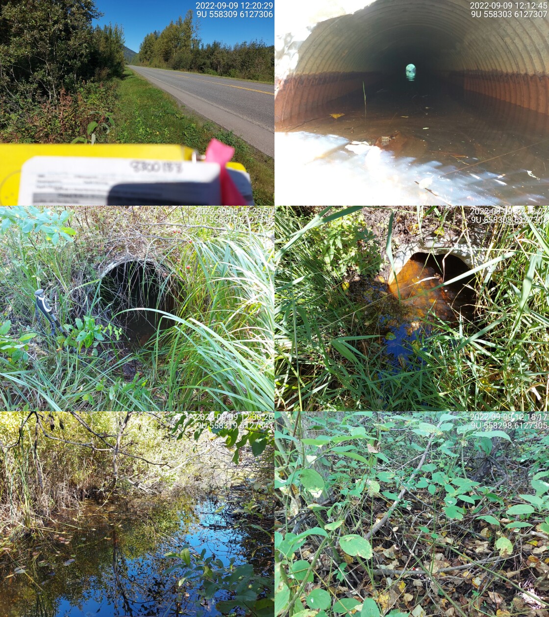
|
|||
| Comments: Dewatered downstream, but there’s water in the culvert. Water upstream, opens up to big wetland and floodplain. 12:03 |
| Location and Stream Data |
|
Crossing Characteristics | – |
|---|---|---|---|
| Date | 2022-09-09 | Crossing Sub Type | Round Culvert |
| PSCIS ID | 198203 | Diameter (m) | 0.8 |
| External ID | 2022090901 | Length (m) | 11 |
| Crew | MW | Embedded | No |
| UTM Zone | 9 | Depth Embedded (m) | – |
| Easting | 549761.1 | Resemble Channel | No |
| Northing | 6140313 | Backwatered | No |
| Stream | Tributary to Kitwanga River | Percent Backwatered | – |
| Road | Kitwancool Branch 2 FSR | Fill Depth (m) | 1.2 |
| Road Tenure | MoF 8687 | Outlet Drop (m) | 0 |
| Channel Width (m) | 1.7 | Outlet Pool Depth (m) | 0.2 |
| Stream Slope (%) | 3.5 | Inlet Drop | No |
| Beaver Activity | No | Slope (%) | 0.5 |
| Habitat Value | Medium | Valley Fill | Deep Fill |
| Final score | 16 | Barrier Result | Potential |
| Fix type | Replace Structure with Streambed Simulation CBS | Fix Span / Diameter | 3 |
Photos: PSCIS ID 198203. From top left clockwise: Road/Site Card, Barrel, Outlet, Downstream, Upstream, Inlet.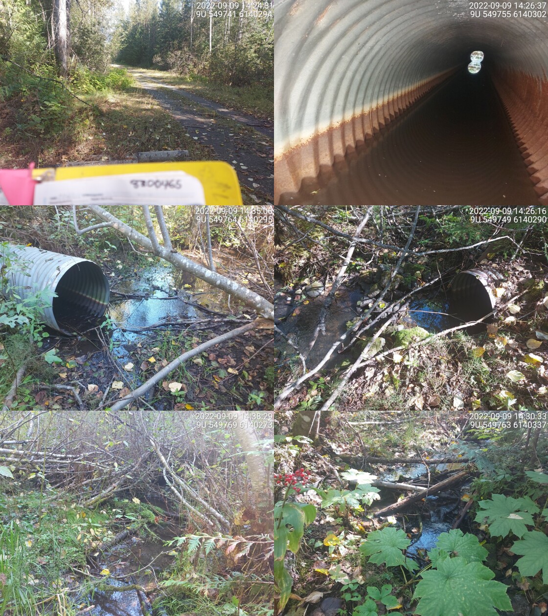
|
|||
| Comments: Cascade downstream of culvert that may block smaller fish. Approx 1m in height. No outlet drop. Good habitat upstream with lots of veg cover and LWD, no gravels or cobbles. Mostly fines and instream vegetation. 14:21 |
| Location and Stream Data |
|
Crossing Characteristics | – |
|---|---|---|---|
| Date | 2022-09-05 | Crossing Sub Type | Round Culvert |
| PSCIS ID | 198204 | Diameter (m) | 1 |
| External ID | 8302421 | Length (m) | 10 |
| Crew | AI | Embedded | No |
| UTM Zone | 9 | Depth Embedded (m) | – |
| Easting | 567222.2 | Resemble Channel | No |
| Northing | 6154120 | Backwatered | Yes |
| Stream | Tributary to Kispiox River | Percent Backwatered | 100 |
| Road | Helen 9000 | Fill Depth (m) | 0.5 |
| Road Tenure | BCTS 8243 | Outlet Drop (m) | 0 |
| Channel Width (m) | 15 | Outlet Pool Depth (m) | 1 |
| Stream Slope (%) | 0 | Inlet Drop | No |
| Beaver Activity | Yes | Slope (%) | 0 |
| Habitat Value | Low | Valley Fill | Deep Fill |
| Final score | 16 | Barrier Result | Potential |
| Fix type | Replace with New Open Bottom Structure | Fix Span / Diameter | 20 |
Photos: PSCIS ID 198204. From top left clockwise: Road/Site Card, Barrel, Outlet, Downstream, Upstream, Inlet.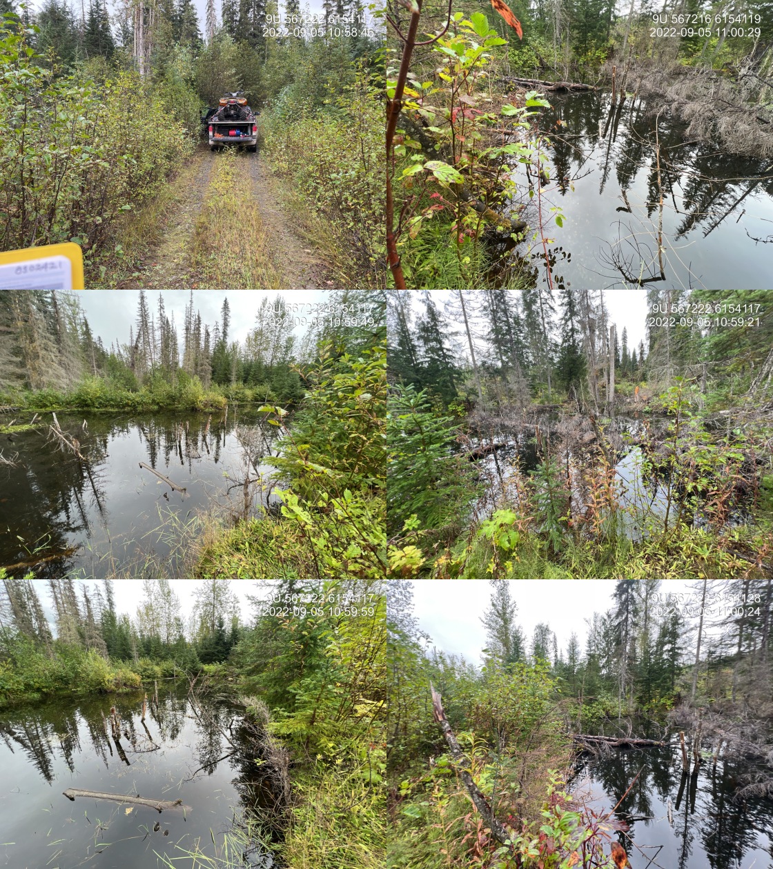
|
|||
| Comments: No structure visible. Beaver ponds on both sides of the road. Diameter estimated. Large mature beaver dam located approximately 10 m downstream of road. 10:56 |
| Location and Stream Data |
|
Crossing Characteristics | – |
|---|---|---|---|
| Date | 2022-09-05 | Crossing Sub Type | Round Culvert |
| PSCIS ID | 198205 | Diameter (m) | 0.8 |
| External ID | 8302065 | Length (m) | 10 |
| Crew | AI | Embedded | No |
| UTM Zone | 9 | Depth Embedded (m) | – |
| Easting | 566030.3 | Resemble Channel | No |
| Northing | 6153077 | Backwatered | No |
| Stream | Tributary to Kispiox River | Percent Backwatered | – |
| Road | Helen Lake Rd | Fill Depth (m) | 1.5 |
| Road Tenure | BCTS 8243 | Outlet Drop (m) | 0 |
| Channel Width (m) | 2.2 | Outlet Pool Depth (m) | 0.1 |
| Stream Slope (%) | 15 | Inlet Drop | No |
| Beaver Activity | Yes | Slope (%) | 3 |
| Habitat Value | Low | Valley Fill | Bedrock |
| Final score | 26 | Barrier Result | Barrier |
| Fix type | Replace with New Open Bottom Structure | Fix Span / Diameter | 10 |
Photos: PSCIS ID 198205. From top left clockwise: Road/Site Card, Barrel, Outlet, Downstream, Upstream, Inlet.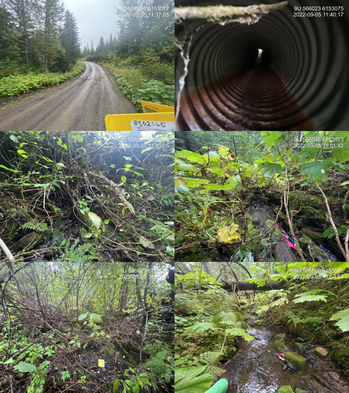
|
|||
| Comments: Natural bed rock cascade of greater than 20% immediately downstream of culvert outlet for a distance of approximately 20 m. 11:35 |
| Location and Stream Data |
|
Crossing Characteristics | – |
|---|---|---|---|
| Date | 2022-09-05 | Crossing Sub Type | Round Culvert |
| PSCIS ID | 198206 | Diameter (m) | 0.65 |
| External ID | 8300118 | Length (m) | 12 |
| Crew | AI | Embedded | No |
| UTM Zone | 9 | Depth Embedded (m) | – |
| Easting | 572865 | Resemble Channel | No |
| Northing | 6149158 | Backwatered | No |
| Stream | Tributary to McCully Creek | Percent Backwatered | – |
| Road | Helen Lake Rd | Fill Depth (m) | 1.5 |
| Road Tenure | MoTi Local | Outlet Drop (m) | 0 |
| Channel Width (m) | 2 | Outlet Pool Depth (m) | 0 |
| Stream Slope (%) | 9 | Inlet Drop | No |
| Beaver Activity | No | Slope (%) | 6 |
| Habitat Value | Low | Valley Fill | Deep Fill |
| Final score | 26 | Barrier Result | Barrier |
| Fix type | Replace with New Open Bottom Structure | Fix Span / Diameter | 10 |
Photos: PSCIS ID 198206. From top left clockwise: Road/Site Card, Barrel, Outlet, Downstream, Upstream, Inlet.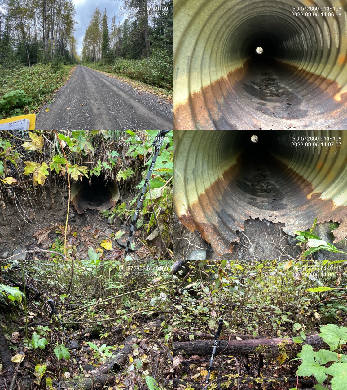
|
|||
| Comments: Dry draw with all organic substrate and moss throughout channel. Culvert outlet is severely rusted with the bottom completely corroded for the last approximately 1 m. Unlikely a fish bearing stream. 13:39 |
| Location and Stream Data |
|
Crossing Characteristics | – |
|---|---|---|---|
| Date | 2022-09-05 | Crossing Sub Type | Round Culvert |
| PSCIS ID | 198207 | Diameter (m) | 0.9 |
| External ID | 2022090501 | Length (m) | 14 |
| Crew | AI | Embedded | No |
| UTM Zone | 9 | Depth Embedded (m) | – |
| Easting | 573065.7 | Resemble Channel | No |
| Northing | 6152232 | Backwatered | Yes |
| Stream | Tributary to Kispiox River | Percent Backwatered | 50 |
| Road | Poplar Park Rd | Fill Depth (m) | 1.5 |
| Road Tenure | MoTi Local | Outlet Drop (m) | 0 |
| Channel Width (m) | 2.2 | Outlet Pool Depth (m) | 0.3 |
| Stream Slope (%) | 1 | Inlet Drop | Yes |
| Beaver Activity | Yes | Slope (%) | 1 |
| Habitat Value | High | Valley Fill | Deep Fill |
| Final score | 21 | Barrier Result | Barrier |
| Fix type | Replace with New Open Bottom Structure | Fix Span / Diameter | 10 |
Photos: PSCIS ID 198207. From top left clockwise: Road/Site Card, Barrel, Outlet, Downstream, Upstream, Inlet.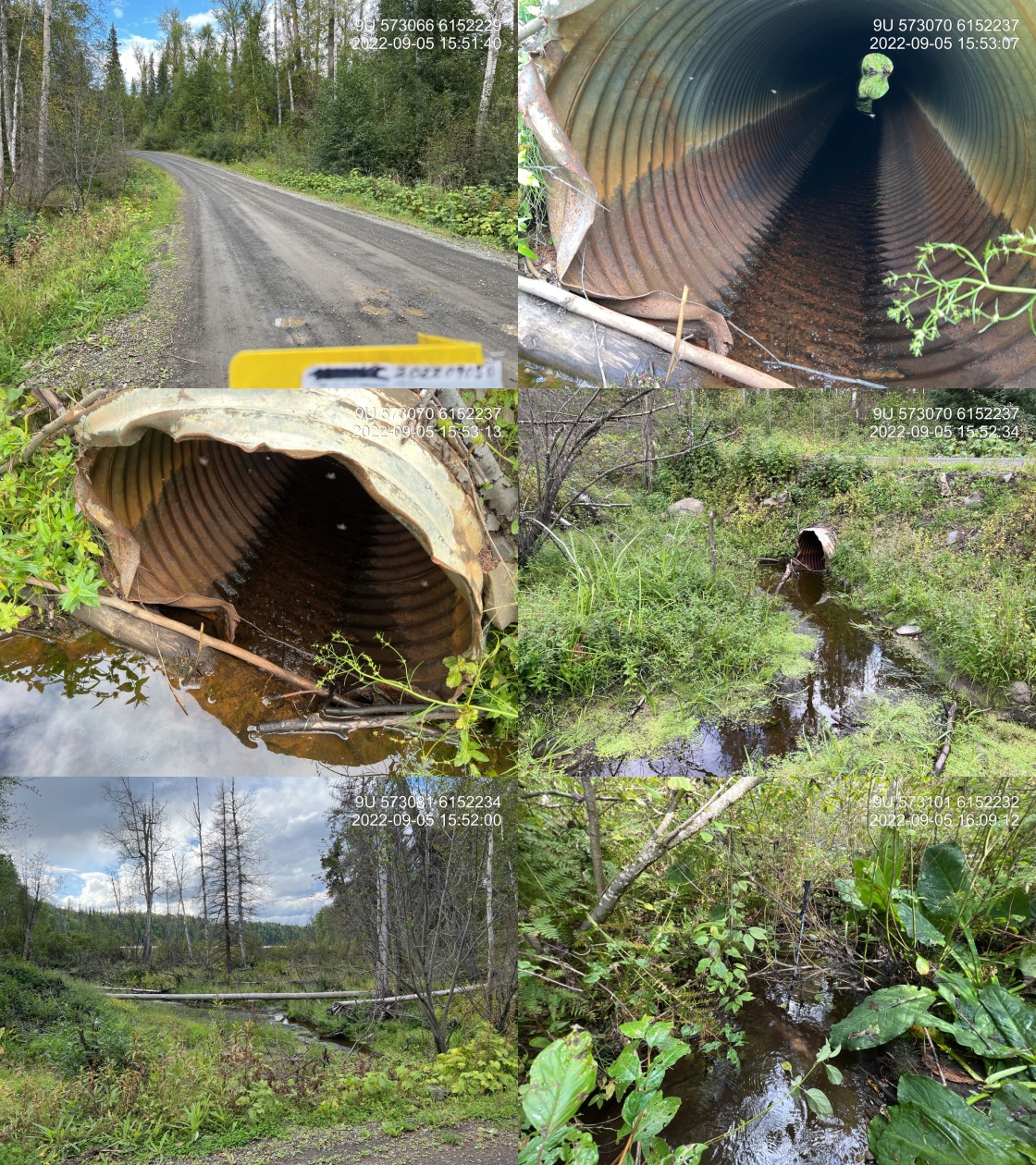
|
|||
| Comments: Pentz Lake is located approximately 50 m upstream. Inlet of culvert is significantly damaged with metal that in words. Culvert is separating approximately halfway through the pipe. Pipe is quite corroded. Pentz Lake rec site is located approximately 2 to 300 m up the road. 15:30 |
| Location and Stream Data |
|
Crossing Characteristics | – |
|---|---|---|---|
| Date | 2022-09-06 | Crossing Sub Type | Round Culvert |
| PSCIS ID | 198208 | Diameter (m) | 0.9 |
| External ID | 8300030 | Length (m) | 18 |
| Crew | AI | Embedded | No |
| UTM Zone | 9 | Depth Embedded (m) | – |
| Easting | 545529.3 | Resemble Channel | No |
| Northing | 6170759 | Backwatered | No |
| Stream | Tributary to Sweetin River | Percent Backwatered | – |
| Road | Kispiox Valley Rd | Fill Depth (m) | 2.5 |
| Road Tenure | MoTi Local | Outlet Drop (m) | 0.4 |
| Channel Width (m) | 0.8 | Outlet Pool Depth (m) | 0.1 |
| Stream Slope (%) | 10 | Inlet Drop | Yes |
| Beaver Activity | No | Slope (%) | 2 |
| Habitat Value | Low | Valley Fill | Deep Fill |
| Final score | 28 | Barrier Result | Barrier |
| Fix type | Replace Structure with Streambed Simulation CBS | Fix Span / Diameter | 3 |
Photos: PSCIS ID 198208. From top left clockwise: Road/Site Card, Barrel, Outlet, Downstream, Upstream, Inlet.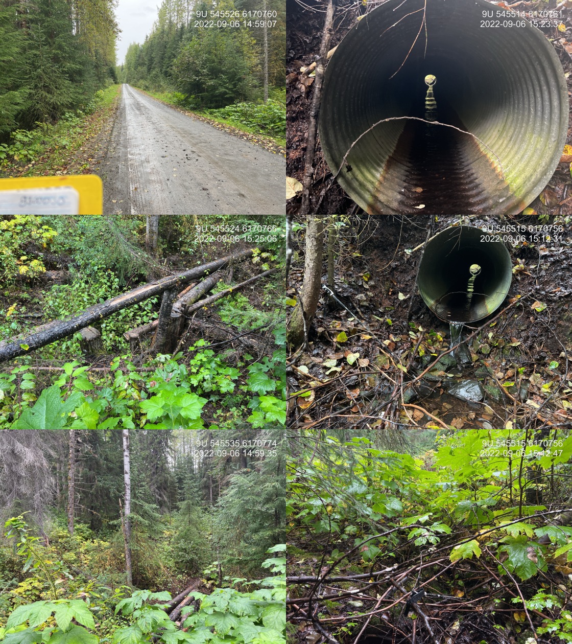
|
|||
| Comments: Mossy draw. Channel is very small and poorly defined. Very unlikely that this is fish habitat. Inlet covered with significant amounts of debris. 14:54 |
| Location and Stream Data |
|
Crossing Characteristics | – |
|---|---|---|---|
| Date | 2022-09-06 | Crossing Sub Type | Round Culvert |
| PSCIS ID | 198209 | Diameter (m) | 0.9 |
| External ID | 8300111 | Length (m) | 15 |
| Crew | AI | Embedded | No |
| UTM Zone | 9 | Depth Embedded (m) | – |
| Easting | 553817.5 | Resemble Channel | No |
| Northing | 6166233 | Backwatered | No |
| Stream | Tributary to Kispiox River | Percent Backwatered | – |
| Road | Kispiox Valley Rd | Fill Depth (m) | 2 |
| Road Tenure | MoTi Local | Outlet Drop (m) | 3 |
| Channel Width (m) | 1.9 | Outlet Pool Depth (m) | 0 |
| Stream Slope (%) | 9 | Inlet Drop | No |
| Beaver Activity | No | Slope (%) | 10 |
| Habitat Value | Low | Valley Fill | Deep Fill |
| Final score | 39 | Barrier Result | Barrier |
| Fix type | Replace Structure with Streambed Simulation CBS | Fix Span / Diameter | 3 |
Photos: PSCIS ID 198209. From top left clockwise: Road/Site Card, Barrel, Outlet, Downstream, Upstream, Inlet.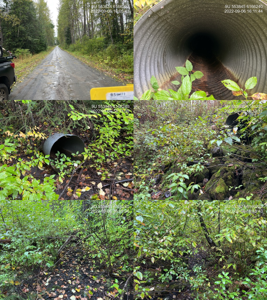
|
|||
| Comments: Dry at time of survey. Significant moss on rocks throughout channel indicates dry for a good portion of the year. Culvert is perched 3 m from stream channel with outlet emptying onto riprap. Culvert is bent severely in middle. 16:03 |
| Location and Stream Data |
|
Crossing Characteristics | – |
|---|---|---|---|
| Date | 2022-09-06 | Crossing Sub Type | Round Culvert |
| PSCIS ID | 198210 | Diameter (m) | 1.3 |
| External ID | 8302403 | Length (m) | 19 |
| Crew | AI | Embedded | Yes |
| UTM Zone | 9 | Depth Embedded (m) | 0.3 |
| Easting | 542451.6 | Resemble Channel | Yes |
| Northing | 6168062 | Backwatered | No |
| Stream | Tributary to Kispiox River | Percent Backwatered | – |
| Road | Mitten Mainline | Fill Depth (m) | 1 |
| Road Tenure | MoF 9657 | Outlet Drop (m) | 0 |
| Channel Width (m) | 4.3 | Outlet Pool Depth (m) | 0 |
| Stream Slope (%) | 9 | Inlet Drop | Yes |
| Beaver Activity | No | Slope (%) | 3.5 |
| Habitat Value | Low | Valley Fill | Deep Fill |
| Final score | 19 | Barrier Result | Potential |
| Fix type | Replace with New Open Bottom Structure | Fix Span / Diameter | 10 |
Photos: PSCIS ID 198210. From top left clockwise: Road/Site Card, Barrel, Outlet, Downstream, Upstream, Inlet.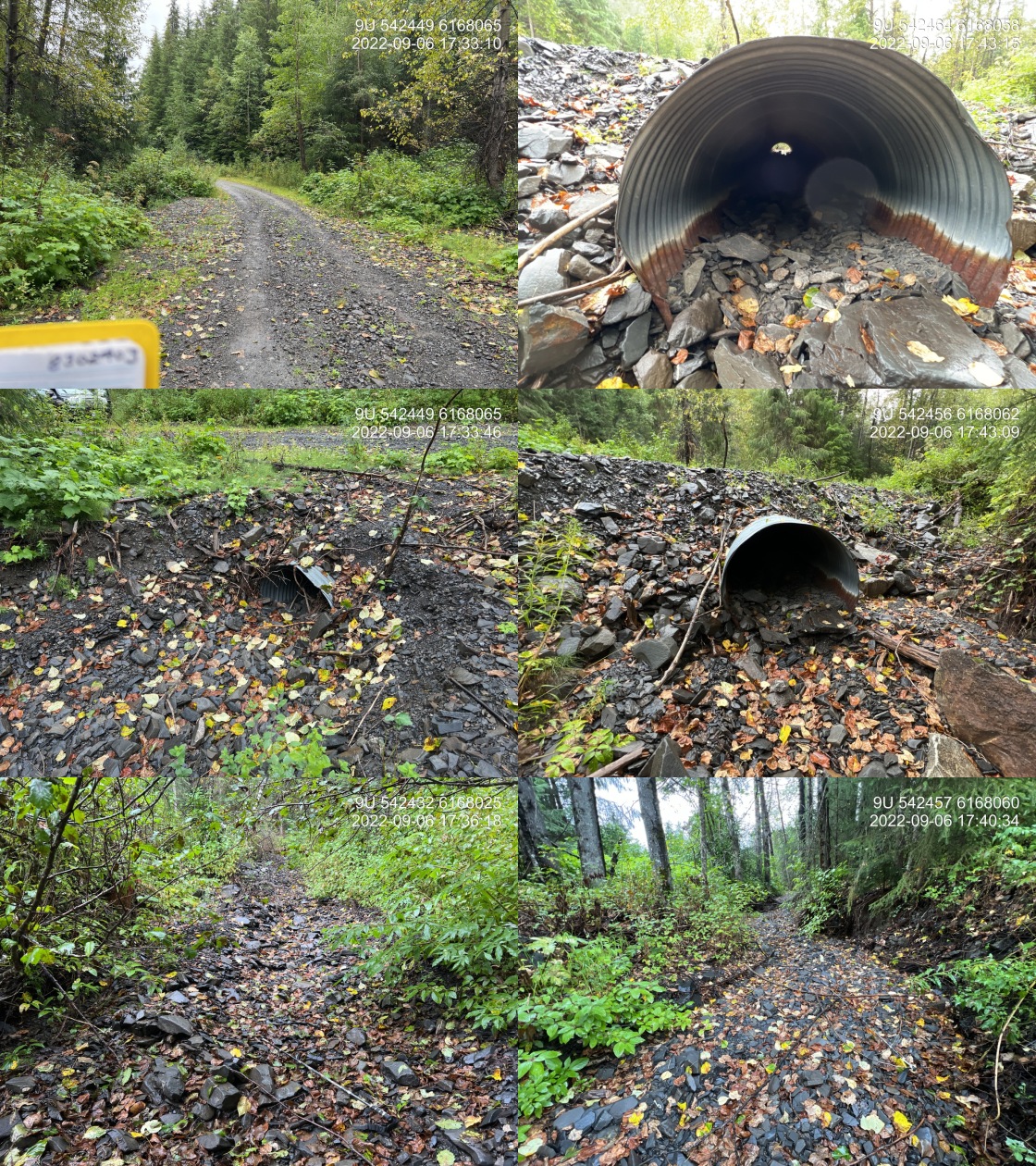
|
|||
| Comments: Stream dry at time of assessment. Significant accumulation of debris just upstream of the inlet. 17:30 |
| Location and Stream Data |
|
Crossing Characteristics | – |
|---|---|---|---|
| Date | 2022-09-06 | Crossing Sub Type | Pipe Arch |
| PSCIS ID | 198211 | Diameter (m) | 6 |
| External ID | 8302407 | Length (m) | 20 |
| Crew | AI | Embedded | – |
| UTM Zone | 9 | Depth Embedded (m) | – |
| Easting | 548521.6 | Resemble Channel | – |
| Northing | 6165905 | Backwatered | – |
| Stream | Tributary to Kispiox River | Percent Backwatered | – |
| Road | Mitten Mainline | Fill Depth (m) | – |
| Road Tenure | MoF 9657 | Outlet Drop (m) | – |
| Channel Width (m) | – | Outlet Pool Depth (m) | – |
| Stream Slope (%) | – | Inlet Drop | – |
| Beaver Activity | No | Slope (%) | – |
| Habitat Value | – | Valley Fill | – |
| Final score | 3 | Barrier Result | Passable |
| Fix type | – | Fix Span / Diameter | – |
Photos: PSCIS ID 198211. From top left clockwise: Road/Site Card, Barrel, Outlet, Downstream, Upstream, Inlet.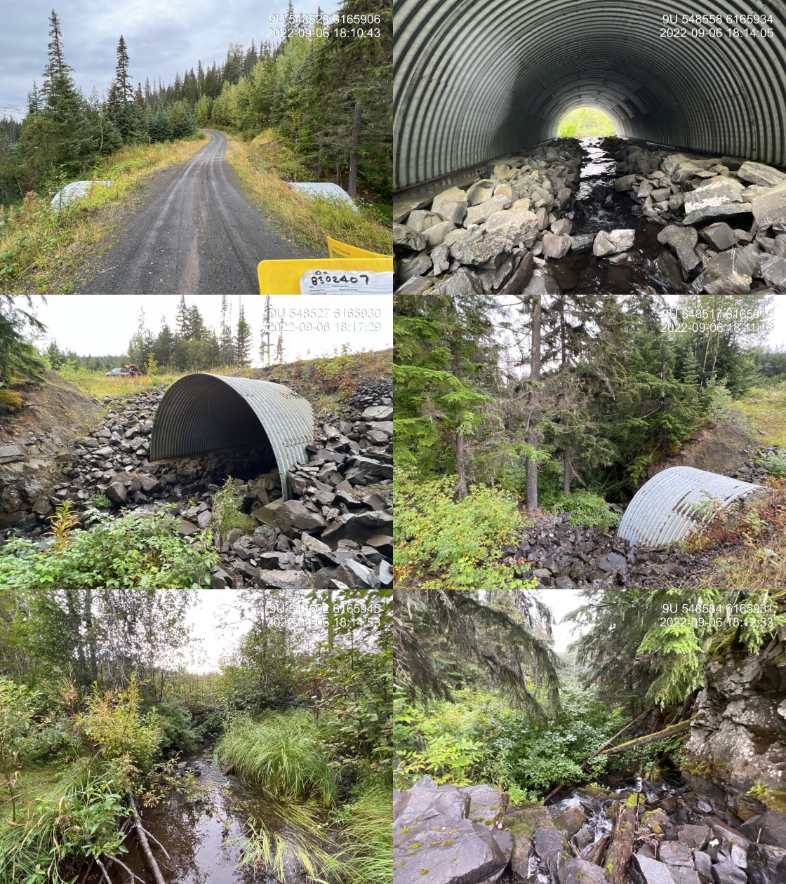
|
|||
| Comments: Extremely steep rock steps immediately downstream of outlet. Downstream is 20% gradient with >1m steps. FISS point from Triton indicates there is a 2 m barrier downstream that is a barrier to anadromous species. Additionally, there is a 5 m rock documented near the confluence with the Kispiox. 18:09 |
| Location and Stream Data |
|
Crossing Characteristics | – |
|---|---|---|---|
| Date | 2022-09-07 | Crossing Sub Type | Round Culvert |
| PSCIS ID | 198212 | Diameter (m) | 3.9 |
| External ID | 8301754 | Length (m) | 26 |
| Crew | AI | Embedded | Yes |
| UTM Zone | 9 | Depth Embedded (m) | 0.13 |
| Easting | 564129.6 | Resemble Channel | Yes |
| Northing | 6166824 | Backwatered | No |
| Stream | Trib to Cullon Creek | Percent Backwatered | – |
| Road | Kuldo FSR | Fill Depth (m) | 2.5 |
| Road Tenure | MoF 7871 | Outlet Drop (m) | 0 |
| Channel Width (m) | 3.8 | Outlet Pool Depth (m) | 0 |
| Stream Slope (%) | 3 | Inlet Drop | No |
| Beaver Activity | No | Slope (%) | 1.5 |
| Habitat Value | High | Valley Fill | Shallow Fill |
| Final score | 13 | Barrier Result | Passable |
| Fix type | – | Fix Span / Diameter | – |
Photos: PSCIS ID 198212. From top left clockwise: Road/Site Card, Barrel, Outlet, Downstream, Upstream, Inlet.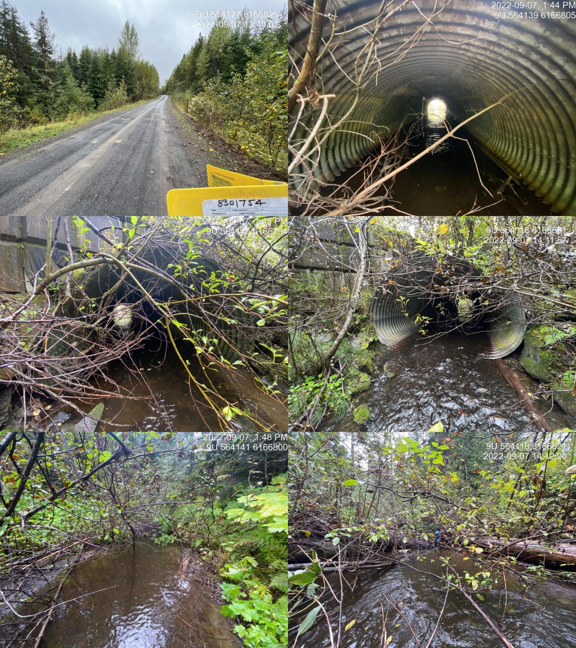
|
|||
| Comments: Baffles installed. 13:32 |
| Location and Stream Data |
|
Crossing Characteristics | – |
|---|---|---|---|
| Date | 2022-09-07 | Crossing Sub Type | Round Culvert |
| PSCIS ID | 198213 | Diameter (m) | 0.5 |
| External ID | 8301749 | Length (m) | 14 |
| Crew | AI JO | Embedded | No |
| UTM Zone | 9 | Depth Embedded (m) | – |
| Easting | 564726.3 | Resemble Channel | No |
| Northing | 6164301 | Backwatered | No |
| Stream | Tributary to Cullon Creek | Percent Backwatered | – |
| Road | Kuldo FSR | Fill Depth (m) | 1 |
| Road Tenure | MoF 7871 | Outlet Drop (m) | 0 |
| Channel Width (m) | 1 | Outlet Pool Depth (m) | 0 |
| Stream Slope (%) | 1 | Inlet Drop | No |
| Beaver Activity | No | Slope (%) | 1 |
| Habitat Value | Low | Valley Fill | Deep Fill |
| Final score | 21 | Barrier Result | Barrier |
| Fix type | Replace Structure with Streambed Simulation CBS | Fix Span / Diameter | 3 |
Photos: PSCIS ID 198213. From top left clockwise: Road/Site Card, Barrel, Outlet, Downstream, Upstream, Inlet.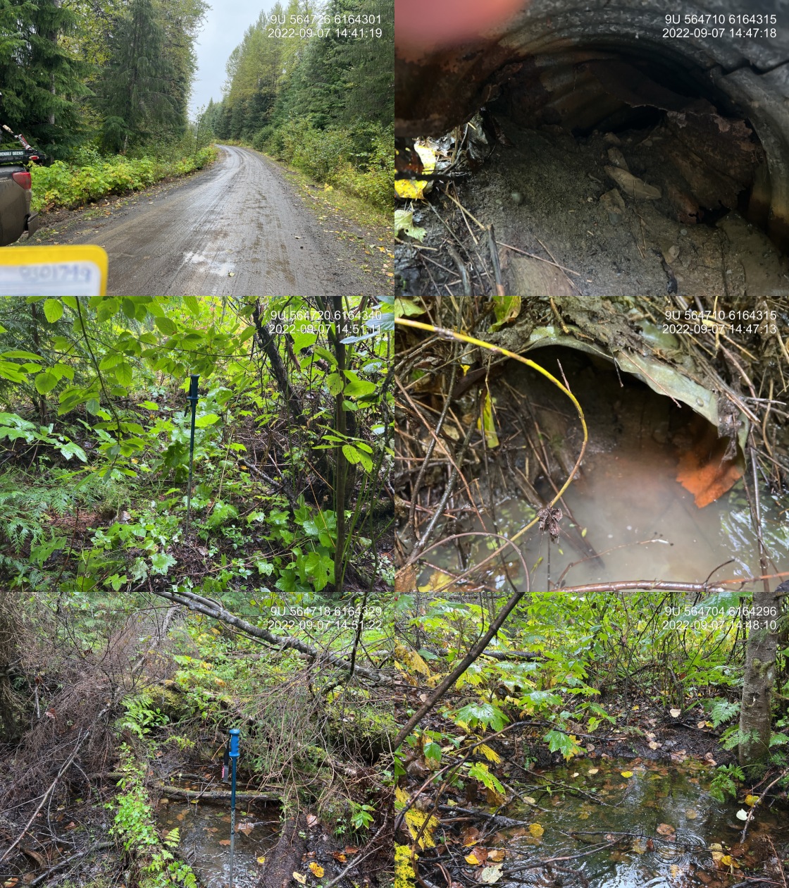
|
|||
| Comments: This is a small non-classified drainage. Culvert is completely plugged and inlet could not be located. Outlet of culvert is severely corroded. Very unlikely that this is a fish bearing system. Culvert slope, channel with, ingredient estimated. 14:39 |
| Location and Stream Data |
|
Crossing Characteristics | – |
|---|---|---|---|
| Date | 2022-09-07 | Crossing Sub Type | Round Culvert |
| PSCIS ID | 198214 | Diameter (m) | 0.95 |
| External ID | 8301748 | Length (m) | 20 |
| Crew | AI | Embedded | No |
| UTM Zone | 9 | Depth Embedded (m) | – |
| Easting | 565280.8 | Resemble Channel | No |
| Northing | 6163976 | Backwatered | No |
| Stream | Tributary to Cullon Creek | Percent Backwatered | – |
| Road | Kuldo FSR | Fill Depth (m) | 2 |
| Road Tenure | MoF 7871 | Outlet Drop (m) | 0.49 |
| Channel Width (m) | 1.6 | Outlet Pool Depth (m) | 0.28 |
| Stream Slope (%) | 2 | Inlet Drop | No |
| Beaver Activity | No | Slope (%) | 2.5 |
| Habitat Value | Low | Valley Fill | Deep Fill |
| Final score | 34 | Barrier Result | Barrier |
| Fix type | Replace Structure with Streambed Simulation CBS | Fix Span / Diameter | 3 |
Photos: PSCIS ID 198214. From top left clockwise: Road/Site Card, Barrel, Outlet, Downstream, Upstream, Inlet.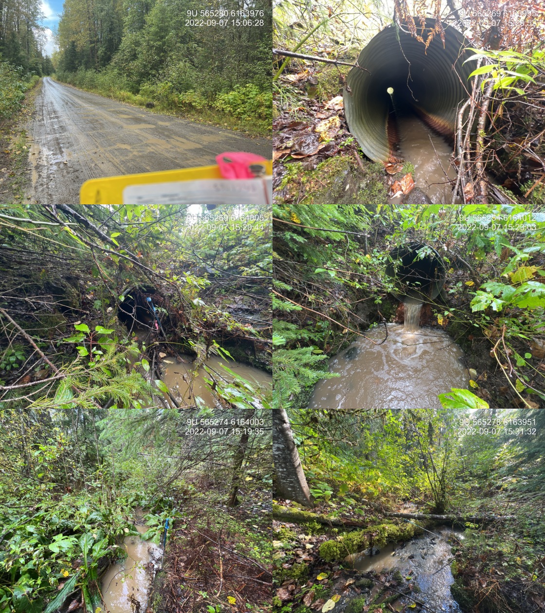
|
|||
| Comments: Approximately 15 m down stream of culvert outlet is a natural rock drop of 0.65 cm on bedrock. Downstream of the culvert the gradient was measured at 17% over a distance of approximately 25 m. Seems very unlikely that a stream this small and steep would have fish presence upstream even if the culvert was fixed. This is unconfirmed. 15:06 |
| Location and Stream Data |
|
Crossing Characteristics | – |
|---|---|---|---|
| Date | 2022-09-09 | Crossing Sub Type | Round Culvert |
| PSCIS ID | 198215 | Diameter (m) | 3.7 |
| External ID | 8300042 | Length (m) | 32 |
| Crew | AI JO | Embedded | No |
| UTM Zone | 9 | Depth Embedded (m) | – |
| Easting | 582153.7 | Resemble Channel | No |
| Northing | 6135026 | Backwatered | No |
| Stream | Tributary to Kispiox River | Percent Backwatered | – |
| Road | Kispiox Westside Rd | Fill Depth (m) | 5.5 |
| Road Tenure | MoTi Local | Outlet Drop (m) | 1.1 |
| Channel Width (m) | 5.3 | Outlet Pool Depth (m) | 0.85 |
| Stream Slope (%) | 5.5 | Inlet Drop | No |
| Beaver Activity | No | Slope (%) | 4 |
| Habitat Value | High | Valley Fill | Deep Fill |
| Final score | 42 | Barrier Result | Barrier |
| Fix type | Replace with New Open Bottom Structure | Fix Span / Diameter | 17.5 |
Photos: PSCIS ID 198215. From top left clockwise: Road/Site Card, Barrel, Outlet, Downstream, Upstream, Inlet.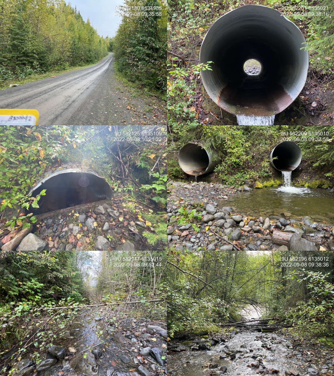
|
|||
| Comments: .75-.90 m lock block step approximately 30 m down stream of culvert. Double pipe however river right pipe is not functioning and has 50% blocked outlet. 9:32 |
| Location and Stream Data |
|
Crossing Characteristics | – |
|---|---|---|---|
| Date | 2022-09-09 | Crossing Sub Type | Round Culvert |
| PSCIS ID | 198216 | Diameter (m) | 2 |
| External ID | 8300054 | Length (m) | 24 |
| Crew | AI | Embedded | Yes |
| UTM Zone | 9 | Depth Embedded (m) | 0.2 |
| Easting | 583025.5 | Resemble Channel | Yes |
| Northing | 6130402 | Backwatered | Yes |
| Stream | Tributary to Skeena River | Percent Backwatered | 95 |
| Road | Kispiox Valley Rd | Fill Depth (m) | 3 |
| Road Tenure | MoTi Arterial | Outlet Drop (m) | 0 |
| Channel Width (m) | 5.6 | Outlet Pool Depth (m) | 0.8 |
| Stream Slope (%) | 1.5 | Inlet Drop | Yes |
| Beaver Activity | Yes | Slope (%) | 0.5 |
| Habitat Value | High | Valley Fill | Deep Fill |
| Final score | 14 | Barrier Result | Passable |
| Fix type | – | Fix Span / Diameter | – |
Photos: PSCIS ID 198216. From top left clockwise: Road/Site Card, Barrel, Outlet, Downstream, Upstream, Inlet.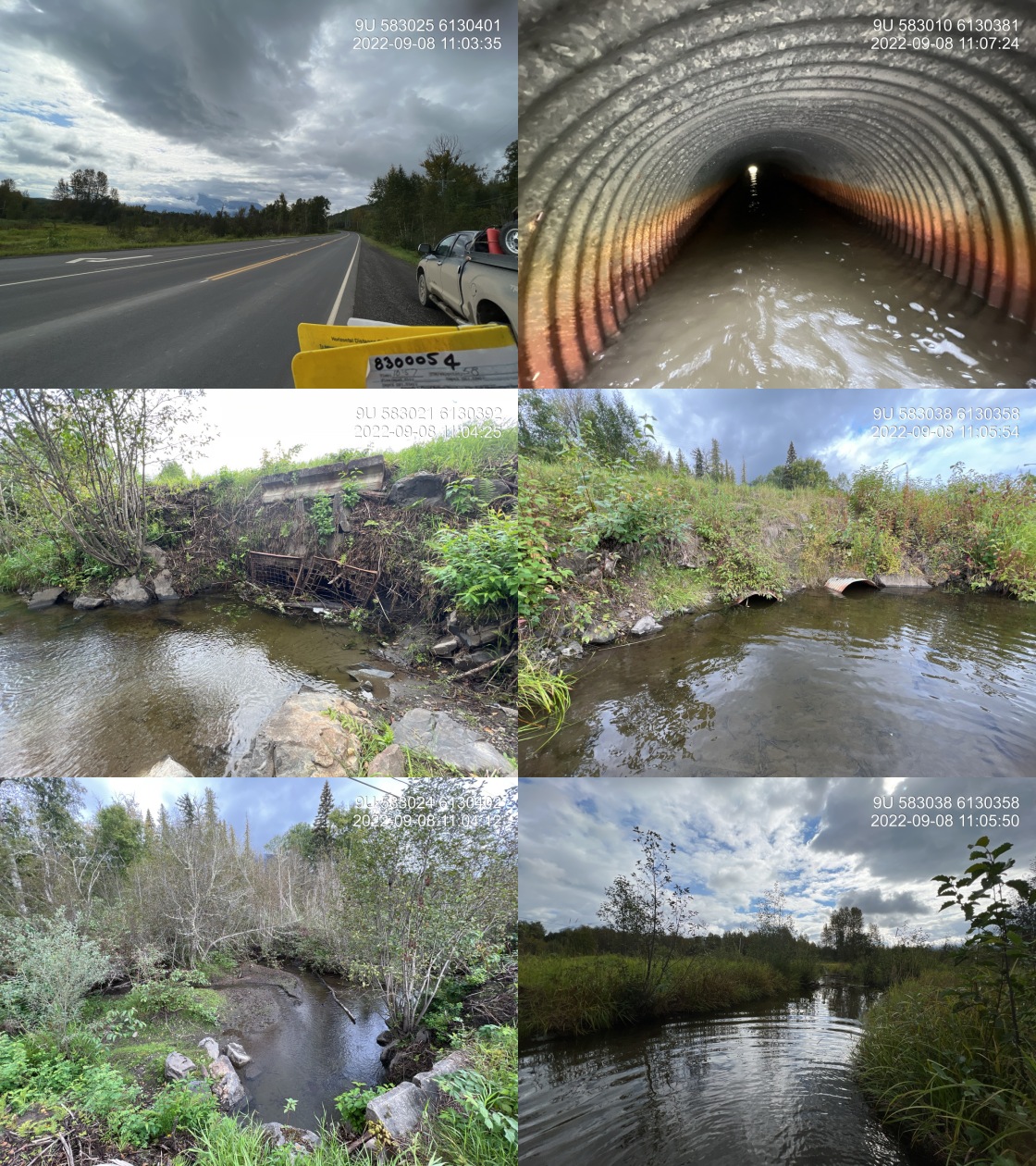
|
|||
| Comments: Culvert appears very old and near end of life. Nice gravels upstream. Flow is moving between the two 1 m pipes. Trash rack on inlet would be barrier to coho moving up to spawn. 10:57 |
| Location and Stream Data |
|
Crossing Characteristics | – |
|---|---|---|---|
| Date | 2022-09-09 | Crossing Sub Type | Round Culvert |
| PSCIS ID | 198217 | Diameter (m) | 2.5 |
| External ID | 8301485 | Length (m) | 10 |
| Crew | AI | Embedded | No |
| UTM Zone | 9 | Depth Embedded (m) | – |
| Easting | 582851.3 | Resemble Channel | No |
| Northing | 6130491 | Backwatered | No |
| Stream | Tributary to Skeena River | Percent Backwatered | – |
| Road | Sik e Dakh Water Tower Rd | Fill Depth (m) | 1 |
| Road Tenure | Sik e Dakh | Outlet Drop (m) | 0.6 |
| Channel Width (m) | 5.6 | Outlet Pool Depth (m) | 0.7 |
| Stream Slope (%) | 1.5 | Inlet Drop | Yes |
| Beaver Activity | Yes | Slope (%) | 3.5 |
| Habitat Value | High | Valley Fill | Deep Fill |
| Final score | 36 | Barrier Result | Barrier |
| Fix type | Replace with New Open Bottom Structure | Fix Span / Diameter | 10 |
Photos: PSCIS ID 198217. From top left clockwise: Road/Site Card, Barrel, Outlet, Downstream, Upstream, Inlet.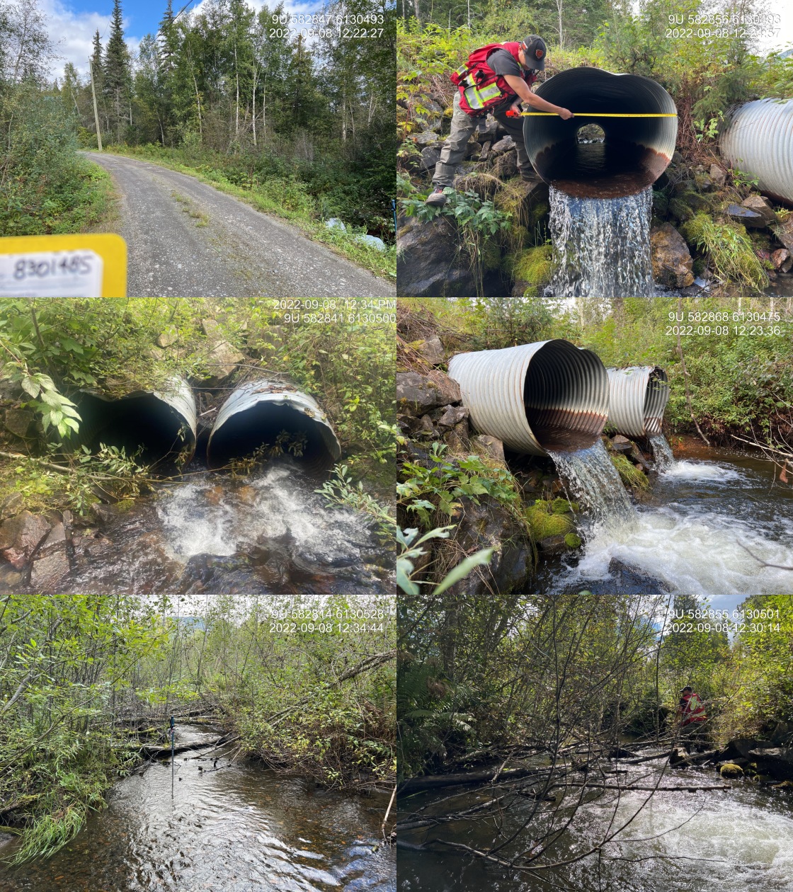
|
|||
| Comments: Francis( chief) indicated this is historic coho harvest and spawning stream. 2 active culverts side by side. Trash rack has been removed from inlet. Inlet has significant amount of debris. Extensive gravels present suitable for coho spawning. Good flow and large stream. On road to water treatment plant within reserve boundaries. 12:20 |
| Location and Stream Data |
|
Crossing Characteristics | – |
|---|---|---|---|
| Date | 2022-09-07 | Crossing Sub Type | Round Culvert |
| PSCIS ID | 198218 | Diameter (m) | 0.6 |
| External ID | 2787053 | Length (m) | 19 |
| Crew | AI JO | Embedded | No |
| UTM Zone | 9 | Depth Embedded (m) | – |
| Easting | 571274.2 | Resemble Channel | No |
| Northing | 6156519 | Backwatered | No |
| Stream | Tributary to Kispiox River | Percent Backwatered | – |
| Road | Kispiox Valley Rd | Fill Depth (m) | 3 |
| Road Tenure | MoTi Local | Outlet Drop (m) | 0 |
| Channel Width (m) | 2 | Outlet Pool Depth (m) | 0.67 |
| Stream Slope (%) | 3.5 | Inlet Drop | Yes |
| Beaver Activity | No | Slope (%) | 3 |
| Habitat Value | Medium | Valley Fill | Deep Fill |
| Final score | 29 | Barrier Result | Barrier |
| Fix type | Replace with New Open Bottom Structure | Fix Span / Diameter | 10 |
Photos: PSCIS ID 198218. From top left clockwise: Road/Site Card, Barrel, Outlet, Downstream, Upstream, Inlet.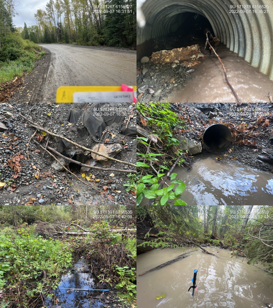
|
|||
| Comments: Culvert has had recent roadwork with significant amounts of fill added. Stream is running clear upstream of the culvert and is extremely turbid downstream due to erosion and runoff related to the construction to fix the road. Inlet of culvert is bent and damaged with a lot of debris at the top end of the pipe blocking significant portions of the flow. Not a modelled crossing location in bcfishpass but is a documented Moti culvert. 16:33 |
| Location and Stream Data |
|
Crossing Characteristics | – |
|---|---|---|---|
| Date | 2022-09-09 | Crossing Sub Type | Round Culvert |
| PSCIS ID | 198219 | Diameter (m) | 0.8 |
| External ID | 8300033 | Length (m) | 13 |
| Crew | AI | Embedded | No |
| UTM Zone | 9 | Depth Embedded (m) | – |
| Easting | 579936.8 | Resemble Channel | No |
| Northing | 6144037 | Backwatered | Yes |
| Stream | Tributary to Kispiox River | Percent Backwatered | 100 |
| Road | Seventeen Mile Rd | Fill Depth (m) | 0.3 |
| Road Tenure | MoTi Local | Outlet Drop (m) | 0 |
| Channel Width (m) | 2.5 | Outlet Pool Depth (m) | 1 |
| Stream Slope (%) | 0 | Inlet Drop | Yes |
| Beaver Activity | Yes | Slope (%) | 0.5 |
| Habitat Value | Medium | Valley Fill | Deep Fill |
| Final score | 16 | Barrier Result | Potential |
| Fix type | Replace with New Open Bottom Structure | Fix Span / Diameter | 10 |
Photos: PSCIS ID 198219. From top left clockwise: Road/Site Card, Barrel, Outlet, Downstream, Upstream, Inlet.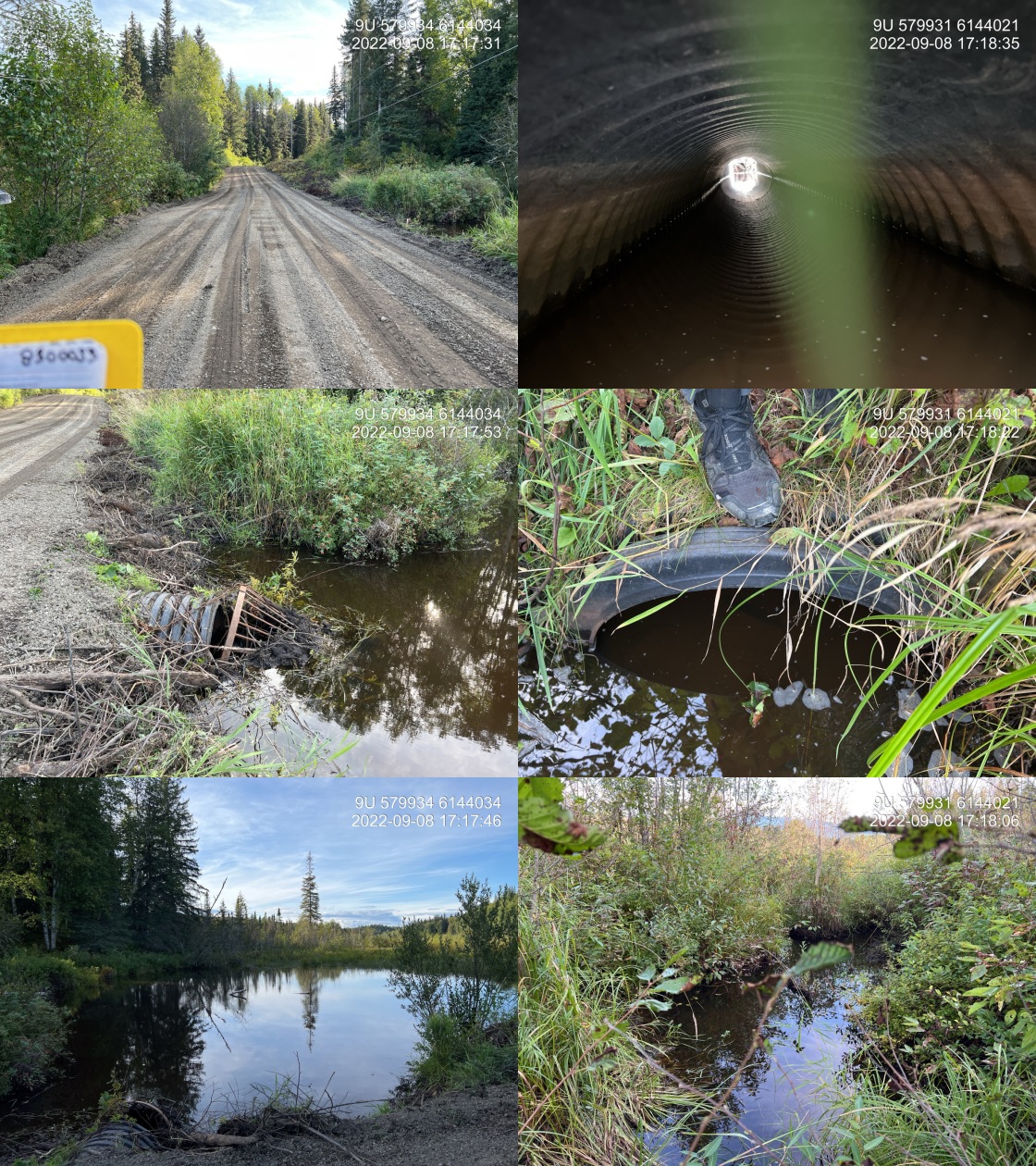
|
|||
| Comments: Wetland upstream. Debris cone on inlet has separated from the culvert. Large inlet drop due to the debris caught in the inlet. 17:14 |
| Location and Stream Data |
|
Crossing Characteristics | – |
|---|---|---|---|
| Date | 2022-09-10 | Crossing Sub Type | Round Culvert |
| PSCIS ID | 198220 | Diameter (m) | 4.8 |
| External ID | 8300095 | Length (m) | 75 |
| Crew | AI | Embedded | No |
| UTM Zone | 9 | Depth Embedded (m) | – |
| Easting | 563431 | Resemble Channel | No |
| Northing | 6109637 | Backwatered | No |
| Stream | Tributary to Kitwanga River | Percent Backwatered | – |
| Road | Hwy 37 | Fill Depth (m) | 9.9 |
| Road Tenure | MoTi Highway | Outlet Drop (m) | 0.72 |
| Channel Width (m) | 5 | Outlet Pool Depth (m) | 0.75 |
| Stream Slope (%) | 2 | Inlet Drop | No |
| Beaver Activity | No | Slope (%) | 1.5 |
| Habitat Value | High | Valley Fill | Deep Fill |
| Final score | 34 | Barrier Result | Barrier |
| Fix type | Replace with New Open Bottom Structure | Fix Span / Diameter | 30.5 |
Photos: PSCIS ID 198220. From top left clockwise: Road/Site Card, Barrel, Outlet, Downstream, Upstream, Inlet.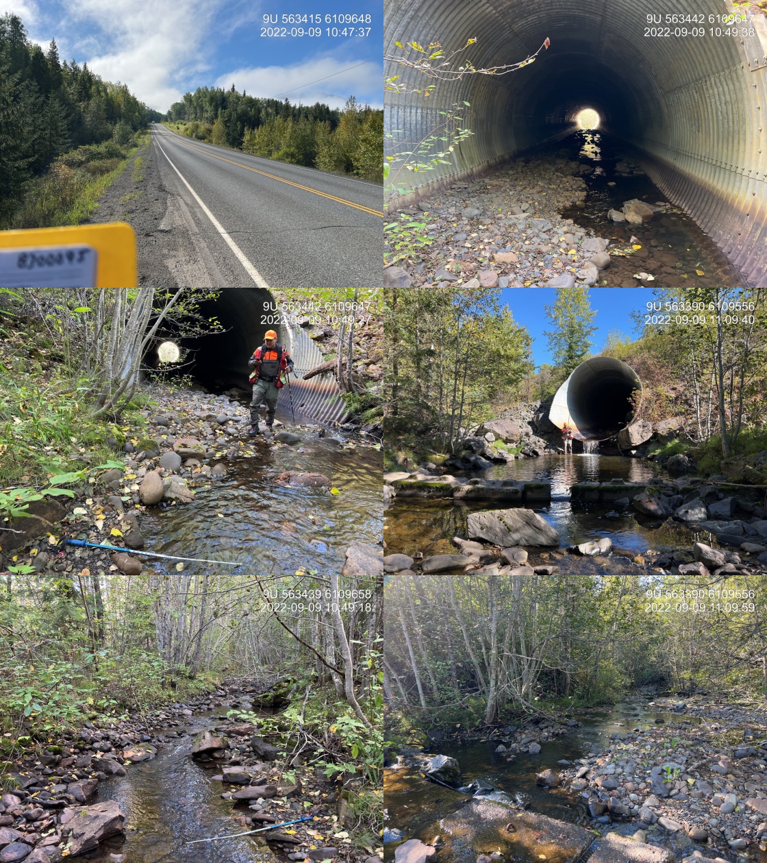
|
|||
| Comments: Historic backwatering with 6 downstream lock block weirs. Skeena Fisheries Commission has assessed site in past. Very large system, pipe embedded until last 10m. Large outlet drop. Lots of algae. 10:46 |
| Location and Stream Data |
|
Crossing Characteristics | – |
|---|---|---|---|
| Date | 2022-09-10 | Crossing Sub Type | Round Culvert |
| PSCIS ID | 198221 | Diameter (m) | 1.3 |
| External ID | 8300178 | Length (m) | 9 |
| Crew | AI | Embedded | No |
| UTM Zone | 9 | Depth Embedded (m) | – |
| Easting | 558773.2 | Resemble Channel | No |
| Northing | 6126523 | Backwatered | No |
| Stream | Tributary to Kitwanga River | Percent Backwatered | – |
| Road | 11A Ave | Fill Depth (m) | 1 |
| Road Tenure | MoTi Local | Outlet Drop (m) | 0 |
| Channel Width (m) | 4 | Outlet Pool Depth (m) | 0.2 |
| Stream Slope (%) | 0 | Inlet Drop | No |
| Beaver Activity | Yes | Slope (%) | 1 |
| Habitat Value | Medium | Valley Fill | Deep Fill |
| Final score | 21 | Barrier Result | Barrier |
| Fix type | Replace with New Open Bottom Structure | Fix Span / Diameter | 10 |
Photos: PSCIS ID 198221. From top left clockwise: Road/Site Card, Barrel, Outlet, Downstream, Upstream, Inlet.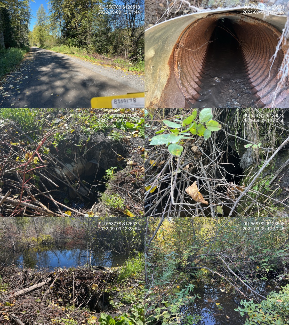
|
|||
| Comments: There are actually two pipes that are 0.65 cm. One pipe has an extension into the beaver dam located immediately upstream of the inlet. This stream is not at the map location as it is located upstream via the Kitwanga River approximately 250 m. 12:14 |
| Location and Stream Data |
|
Crossing Characteristics | – |
|---|---|---|---|
| Date | 2022-09-08 | Crossing Sub Type | Round Culvert |
| PSCIS ID | 198222 | Diameter (m) | 3.8 |
| External ID | 8302257 | Length (m) | 30 |
| Crew | AI | Embedded | No |
| UTM Zone | 9 | Depth Embedded (m) | – |
| Easting | 587054 | Resemble Channel | No |
| Northing | 6138716 | Backwatered | No |
| Stream | Pinenut Creek | Percent Backwatered | – |
| Road | Babine Slide FSR | Fill Depth (m) | 4 |
| Road Tenure | MoF 4841 | Outlet Drop (m) | 0.45 |
| Channel Width (m) | 8.2 | Outlet Pool Depth (m) | 0.4 |
| Stream Slope (%) | 4 | Inlet Drop | No |
| Beaver Activity | No | Slope (%) | 2.5 |
| Habitat Value | High | Valley Fill | Deep Fill |
| Final score | 37 | Barrier Result | Barrier |
| Fix type | Replace with New Open Bottom Structure | Fix Span / Diameter | 13 |
Photos: PSCIS ID 198222. From top left clockwise: Road/Site Card, Barrel, Outlet, Downstream, Upstream, Inlet.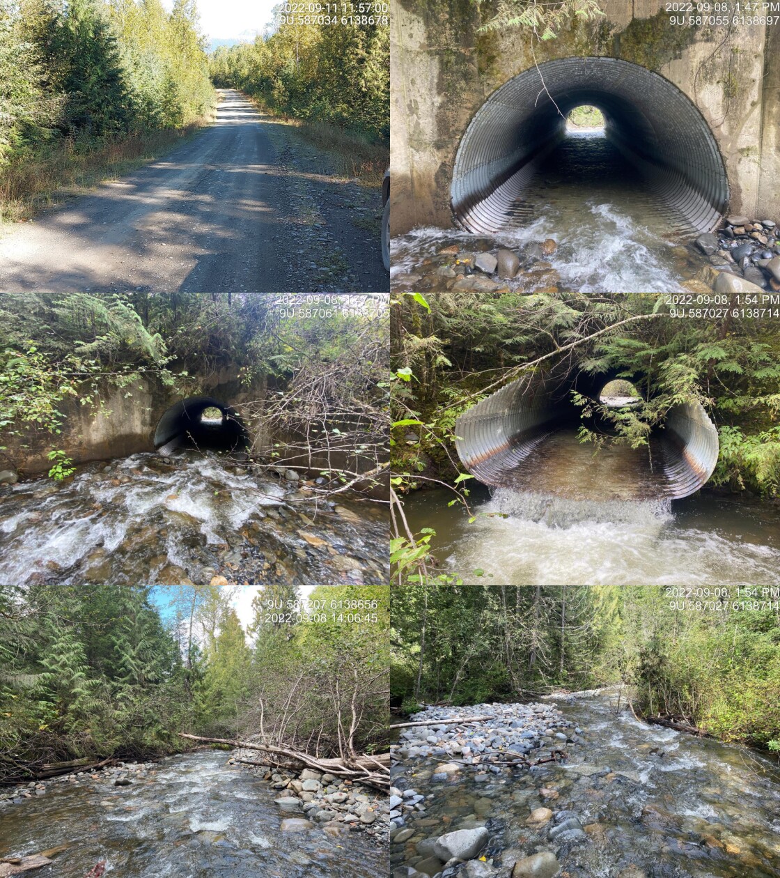
|
|||
| Comments: Structure was replaced in 1985. Concrete wing walls on inlet. Structure in decent shape. 13:39 |
| Location and Stream Data |
|
Crossing Characteristics | – |
|---|---|---|---|
| Date | 2022-09-08 | Crossing Sub Type | Ford |
| PSCIS ID | 198223 | Diameter (m) | – |
| External ID | 8300238 | Length (m) | – |
| Crew | AI | Embedded | – |
| UTM Zone | 9 | Depth Embedded (m) | – |
| Easting | 587207.4 | Resemble Channel | – |
| Northing | 6138659 | Backwatered | – |
| Stream | Pinenut Creek | Percent Backwatered | – |
| Road | Spur | Fill Depth (m) | – |
| Road Tenure | Resource | Outlet Drop (m) | – |
| Channel Width (m) | – | Outlet Pool Depth (m) | – |
| Stream Slope (%) | – | Inlet Drop | – |
| Beaver Activity | No | Slope (%) | – |
| Habitat Value | – | Valley Fill | – |
| Final score | 0 | Barrier Result | Unknown |
| Fix type | – | Fix Span / Diameter | – |
Photos: PSCIS ID 198223. From top left clockwise: Road/Site Card, Barrel, Outlet, Downstream, Upstream, Inlet.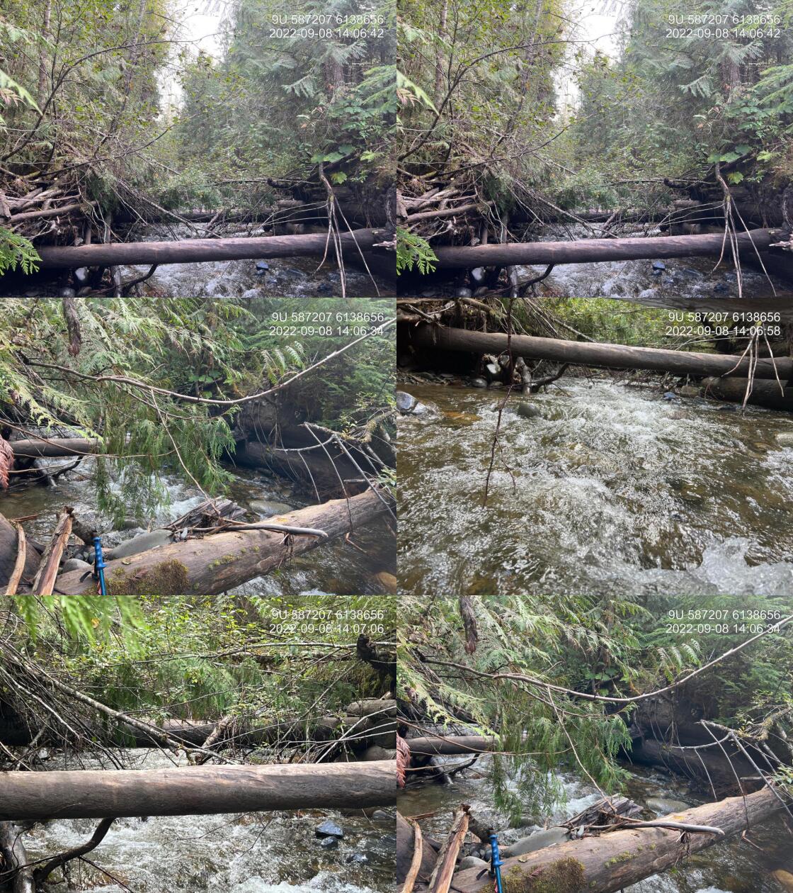
|
|||
| Comments: Collapsed bridge. Some erosion along side but not fish passage issue. 14:04 |
| Location and Stream Data |
|
Crossing Characteristics | – |
|---|---|---|---|
| Date | 2022-09-13 | Crossing Sub Type | Round Culvert |
| PSCIS ID | 198224 | Diameter (m) | 0.8 |
| External ID | 4601067 | Length (m) | 11 |
| Crew | TP VJ | Embedded | No |
| UTM Zone | 9 | Depth Embedded (m) | – |
| Easting | 594902 | Resemble Channel | No |
| Northing | 6075406 | Backwatered | No |
| Stream | Tributary to Zymoetz River | Percent Backwatered | – |
| Road | Hankin FSR | Fill Depth (m) | 1 |
| Road Tenure | MoF 7552 | Outlet Drop (m) | 0 |
| Channel Width (m) | 1.45 | Outlet Pool Depth (m) | 0.45 |
| Stream Slope (%) | 1 | Inlet Drop | No |
| Beaver Activity | No | Slope (%) | 1 |
| Habitat Value | Medium | Valley Fill | Shallow Fill |
| Final score | 21 | Barrier Result | Barrier |
| Fix type | Replace Structure with Streambed Simulation CBS | Fix Span / Diameter | 3 |
Photos: PSCIS ID 198224. From top left clockwise: Road/Site Card, Barrel, Outlet, Downstream, Upstream, Inlet.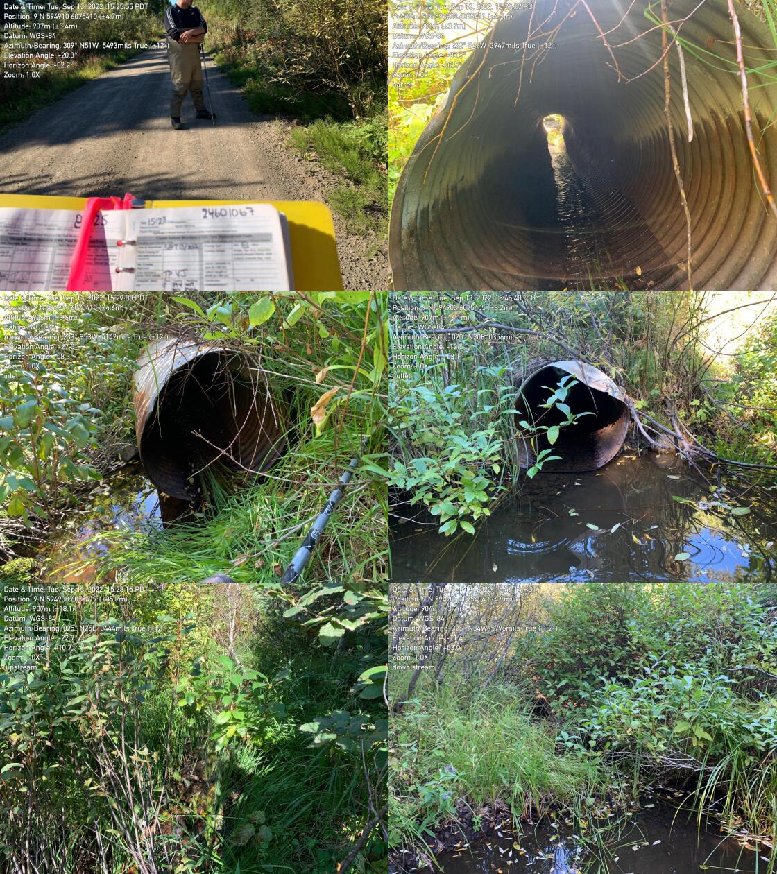
|
|||
| Comments: Round culvert. 15:23:00 |
| Location and Stream Data |
|
Crossing Characteristics | – |
|---|---|---|---|
| Date | 2022-09-23 | Crossing Sub Type | Round Culvert |
| PSCIS ID | 198225 | Diameter (m) | 2.4 |
| External ID | 8300128 | Length (m) | 30 |
| Crew | JO | Embedded | No |
| UTM Zone | 9 | Depth Embedded (m) | – |
| Easting | 584898.7 | Resemble Channel | No |
| Northing | 6152502 | Backwatered | No |
| Stream | Sterritt creek | Percent Backwatered | – |
| Road | Babine Slide FSR | Fill Depth (m) | 4 |
| Road Tenure | MoF 4841 | Outlet Drop (m) | 2 |
| Channel Width (m) | 3.7 | Outlet Pool Depth (m) | 2 |
| Stream Slope (%) | 4.5 | Inlet Drop | Yes |
| Beaver Activity | No | Slope (%) | 3.5 |
| Habitat Value | Low | Valley Fill | Deep Fill |
| Final score | 42 | Barrier Result | Barrier |
| Fix type | Replace with New Open Bottom Structure | Fix Span / Diameter | 13 |
Photos: PSCIS ID 198225. From top left clockwise: Road/Site Card, Barrel, Outlet, Downstream, Upstream, Inlet.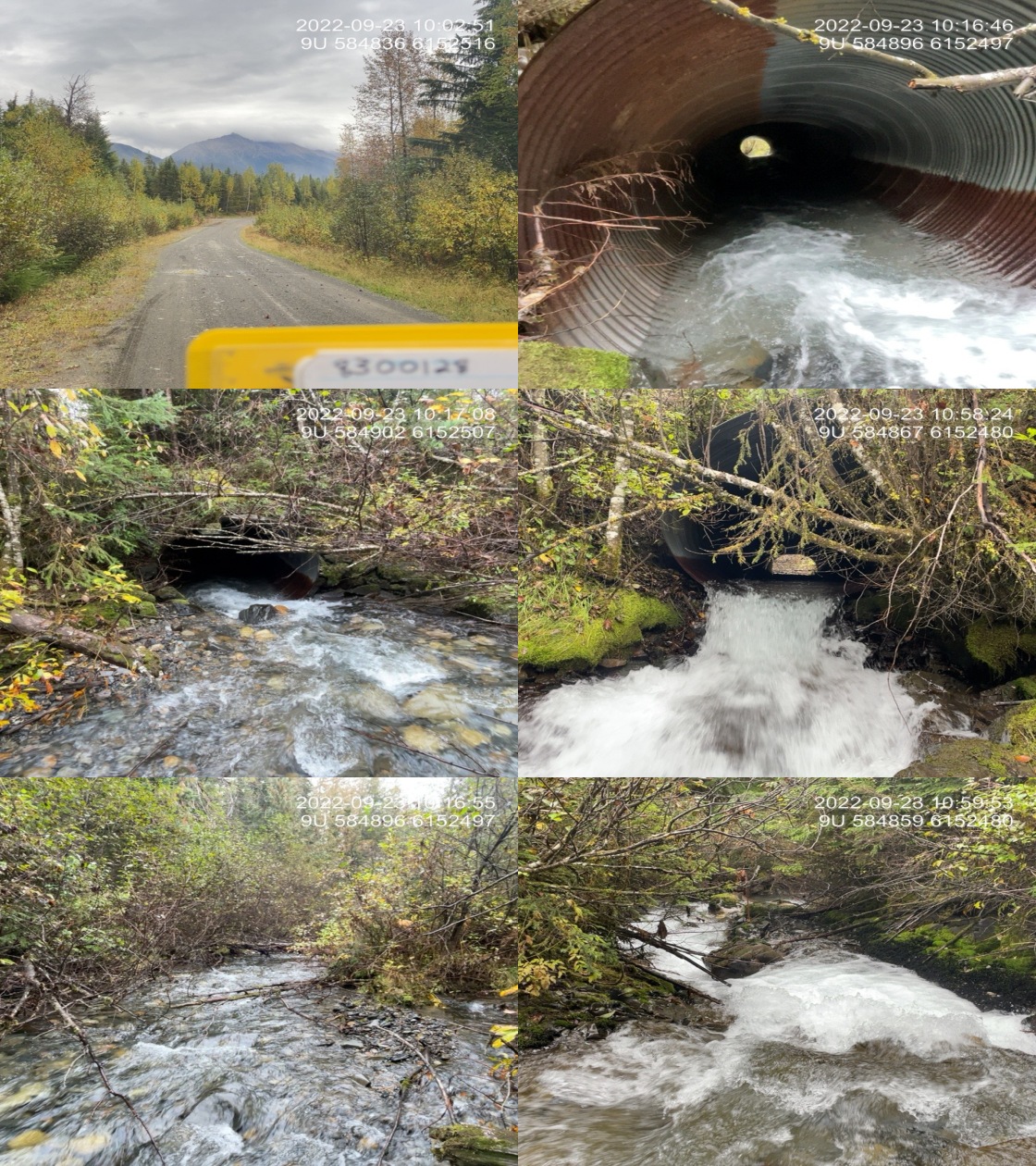
|
|||
| Comments: Culvert is separating 10 meters in from upstream, top of culvert slumping in. 10:06 |
| Location and Stream Data |
|
Crossing Characteristics | – |
|---|---|---|---|
| Date | 2022-09-26 | Crossing Sub Type | Bridge |
| PSCIS ID | 198226 | Diameter (m) | 4.8 |
| External ID | 4709789 | Length (m) | 10 |
| Crew | JO | Embedded | – |
| UTM Zone | 9 | Depth Embedded (m) | – |
| Easting | 581806 | Resemble Channel | – |
| Northing | 6156404 | Backwatered | – |
| Stream | Mtcutcheon creek | Percent Backwatered | – |
| Road | Babine Slide FSR | Fill Depth (m) | – |
| Road Tenure | MoF 4841 | Outlet Drop (m) | – |
| Channel Width (m) | – | Outlet Pool Depth (m) | – |
| Stream Slope (%) | – | Inlet Drop | – |
| Beaver Activity | No | Slope (%) | – |
| Habitat Value | – | Valley Fill | – |
| Final score | 0 | Barrier Result | Passable |
| Fix type | – | Fix Span / Diameter | – |
Photos: PSCIS ID 198226. From top left clockwise: Road/Site Card, Barrel, Outlet, Downstream, Upstream, Inlet.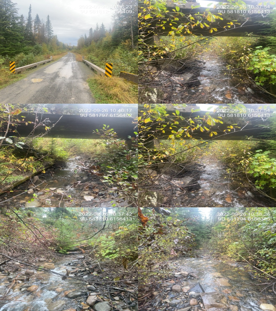
|
|||
| Comments: New structure and old structure was on the side of the road near bridge. 10:35 |
| Location and Stream Data |
|
Crossing Characteristics | – |
|---|---|---|---|
| Date | 2022-09-26 | Crossing Sub Type | Bridge |
| PSCIS ID | 198227 | Diameter (m) | 4.8 |
| External ID | 24709790 | Length (m) | 18 |
| Crew | JO | Embedded | – |
| UTM Zone | 9 | Depth Embedded (m) | – |
| Easting | 583782.1 | Resemble Channel | – |
| Northing | 6153479 | Backwatered | – |
| Stream | Tributary to Skeena River | Percent Backwatered | – |
| Road | Babine Slide FSR | Fill Depth (m) | – |
| Road Tenure | MoF 4841 | Outlet Drop (m) | – |
| Channel Width (m) | – | Outlet Pool Depth (m) | – |
| Stream Slope (%) | – | Inlet Drop | – |
| Beaver Activity | No | Slope (%) | – |
| Habitat Value | – | Valley Fill | – |
| Final score | 3 | Barrier Result | Passable |
| Fix type | – | Fix Span / Diameter | – |
Photos: PSCIS ID 198227. From top left clockwise: Road/Site Card, Barrel, Outlet, Downstream, Upstream, Inlet.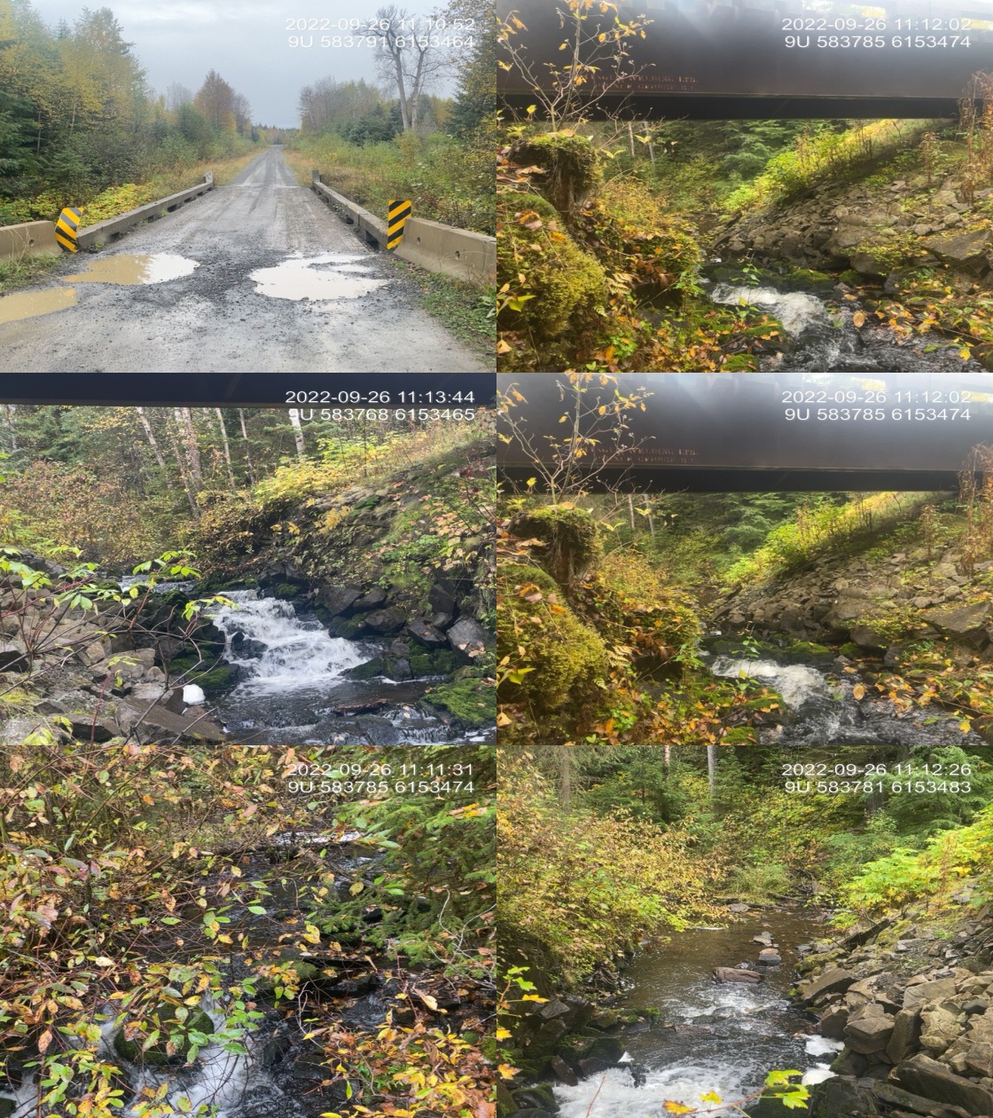
|
|||
| Comments: Bridge. 11:14:00 |
| Location and Stream Data |
|
Crossing Characteristics | – |
|---|---|---|---|
| Date | 2022-09-26 | Crossing Sub Type | Bridge |
| PSCIS ID | 198228 | Diameter (m) | 4.8 |
| External ID | 8302244 | Length (m) | 11 |
| Crew | JO | Embedded | – |
| UTM Zone | 9 | Depth Embedded (m) | – |
| Easting | 583847.9 | Resemble Channel | – |
| Northing | 6153432 | Backwatered | – |
| Stream | Tributary to Skeena River | Percent Backwatered | – |
| Road | Babine Slide FSR | Fill Depth (m) | – |
| Road Tenure | MoF 4841 | Outlet Drop (m) | – |
| Channel Width (m) | – | Outlet Pool Depth (m) | – |
| Stream Slope (%) | – | Inlet Drop | – |
| Beaver Activity | No | Slope (%) | – |
| Habitat Value | – | Valley Fill | – |
| Final score | 0 | Barrier Result | Passable |
| Fix type | – | Fix Span / Diameter | – |
Photos: PSCIS ID 198228. From top left clockwise: Road/Site Card, Barrel, Outlet, Downstream, Upstream, Inlet.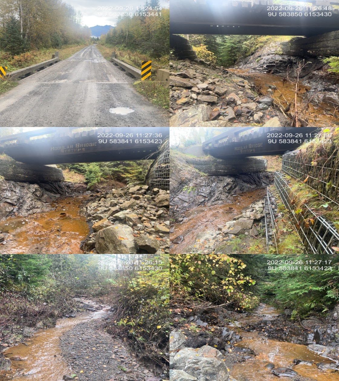
|
|||
| Comments: Retaining fencing installed on both side of streams. Black sediment fencing also installed. 11:28 |
| Location and Stream Data |
|
Crossing Characteristics | – |
|---|---|---|---|
| Date | 2022-09-05 | Crossing Sub Type | Ford |
| PSCIS ID | 198229 | Diameter (m) | – |
| External ID | 8300390 | Length (m) | – |
| Crew | AI | Embedded | – |
| UTM Zone | 9 | Depth Embedded (m) | – |
| Easting | 570745.1 | Resemble Channel | – |
| Northing | 6149438 | Backwatered | – |
| Stream | Tributary to McCully Creek | Percent Backwatered | – |
| Road | Spur | Fill Depth (m) | – |
| Road Tenure | Unclassified | Outlet Drop (m) | – |
| Channel Width (m) | – | Outlet Pool Depth (m) | – |
| Stream Slope (%) | – | Inlet Drop | – |
| Beaver Activity | No | Slope (%) | – |
| Habitat Value | – | Valley Fill | – |
| Final score | 0 | Barrier Result | Unknown |
| Fix type | – | Fix Span / Diameter | – |
Photos: PSCIS ID 198229. From top left clockwise: Road/Site Card, Barrel, Outlet, Downstream, Upstream, Inlet.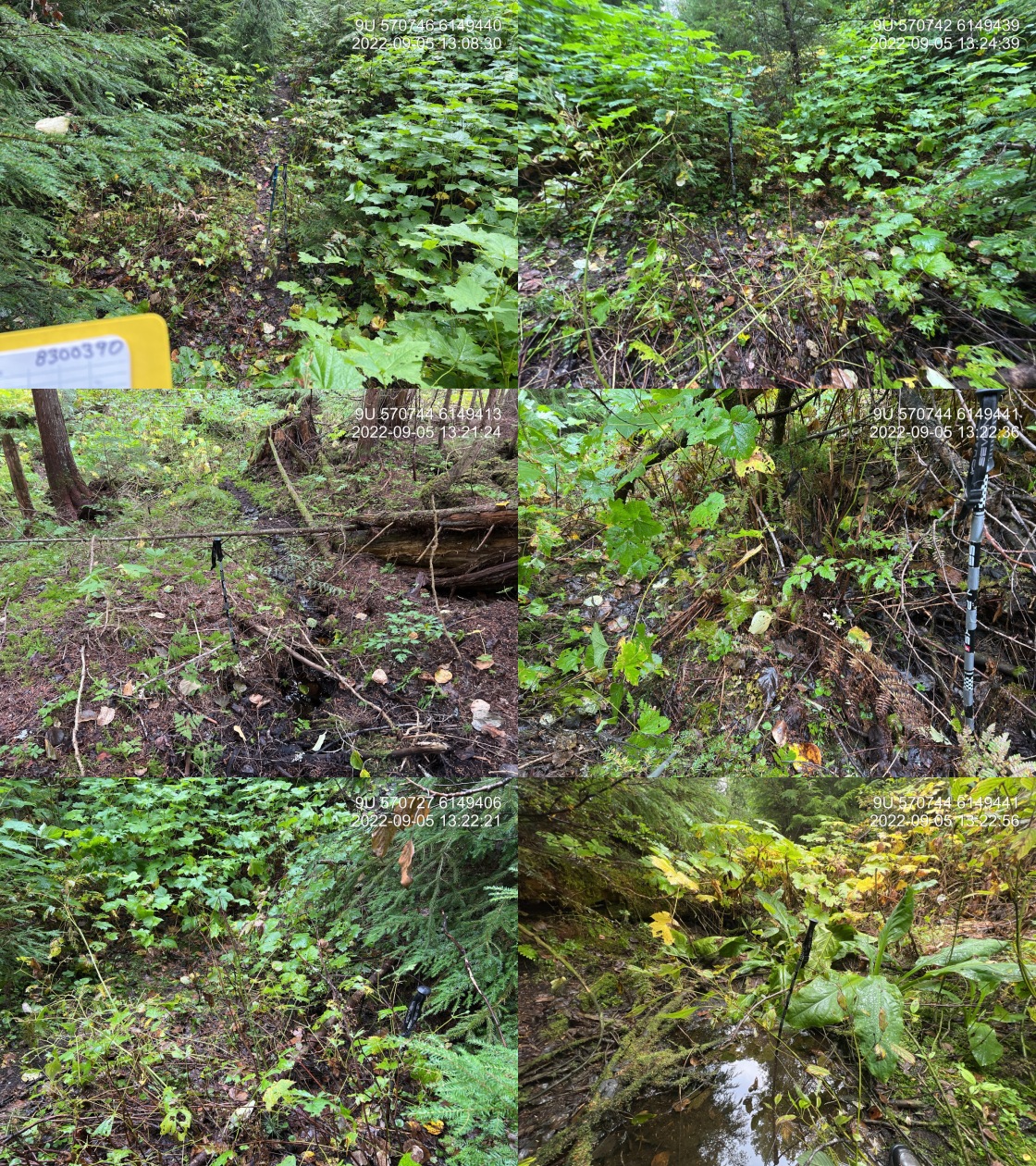
|
|||
| Comments: Deactivated spur road. Ford is not in the same position as shown on the map. 13:08 |
| Location and Stream Data |
|
Crossing Characteristics | – |
|---|---|---|---|
| Date | 2022-09-07 | Crossing Sub Type | Round Culvert |
| PSCIS ID | 198230 | Diameter (m) | 0.5 |
| External ID | 8300108 | Length (m) | 14 |
| Crew | MW | Embedded | No |
| UTM Zone | 9 | Depth Embedded (m) | – |
| Easting | 575356.8 | Resemble Channel | No |
| Northing | 6152462 | Backwatered | No |
| Stream | Trib to Sammon Lake | Percent Backwatered | – |
| Road | Kispiox Valley Rd | Fill Depth (m) | 1 |
| Road Tenure | MoTi Local | Outlet Drop (m) | 0.1 |
| Channel Width (m) | 1.9 | Outlet Pool Depth (m) | 0.3 |
| Stream Slope (%) | 2.5 | Inlet Drop | No |
| Beaver Activity | No | Slope (%) | 3 |
| Habitat Value | Medium | Valley Fill | Deep Fill |
| Final score | 26 | Barrier Result | Barrier |
| Fix type | Replace Structure with Streambed Simulation CBS | Fix Span / Diameter | 3 |
Photos: PSCIS ID 198230. From top left clockwise: Road/Site Card, Barrel, Outlet, Downstream, Upstream, Inlet.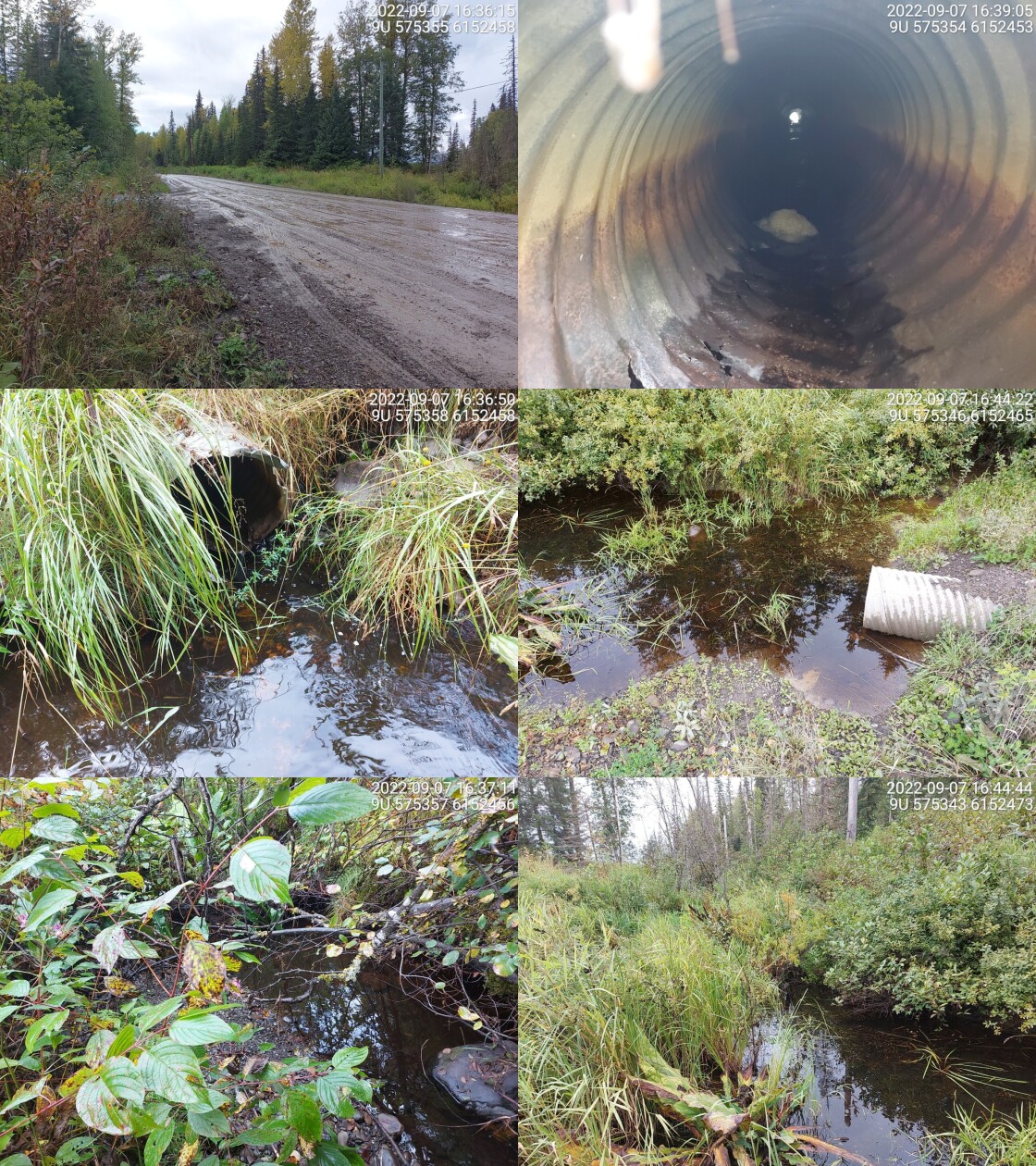
|
|||
| Comments: Fish spotted downstream of culvert. 16:38 |
| Location and Stream Data |
|
Crossing Characteristics | – |
|---|---|---|---|
| Date | 2022-09-06 | Crossing Sub Type | Bridge |
| PSCIS ID | 198231 | Diameter (m) | 9 |
| External ID | 8302755 | Length (m) | 6 |
| Crew | AI | Embedded | – |
| UTM Zone | 9 | Depth Embedded (m) | – |
| Easting | 534422.2 | Resemble Channel | – |
| Northing | 6178965 | Backwatered | – |
| Stream | Tributary to Nangeese River | Percent Backwatered | – |
| Road | Hodder | Fill Depth (m) | – |
| Road Tenure | BCTS 10121 | Outlet Drop (m) | – |
| Channel Width (m) | – | Outlet Pool Depth (m) | – |
| Stream Slope (%) | – | Inlet Drop | – |
| Beaver Activity | No | Slope (%) | – |
| Habitat Value | – | Valley Fill | – |
| Final score | 0 | Barrier Result | Passable |
| Fix type | – | Fix Span / Diameter | – |
Photos: PSCIS ID 198231. From top left clockwise: Road/Site Card, Barrel, Outlet, Downstream, Upstream, Inlet.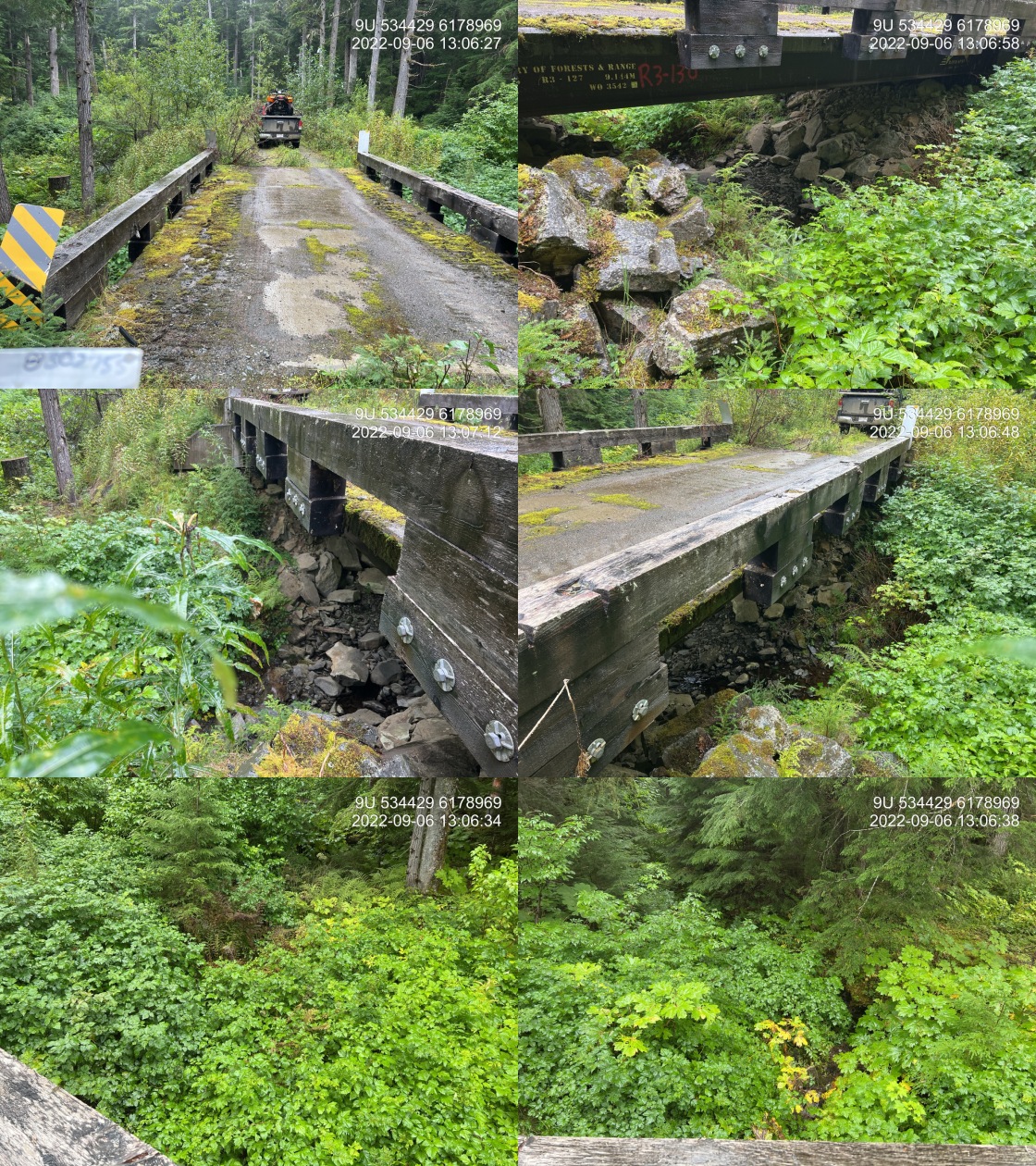
|
|||
| Comments: Bridge. Road fairly brushed in. 13:03 |
| Location and Stream Data |
|
Crossing Characteristics | – |
|---|---|---|---|
| Date | 2022-09-06 | Crossing Sub Type | Bridge |
| PSCIS ID | 198232 | Diameter (m) | 15.5 |
| External ID | 8302410 | Length (m) | 4 |
| Crew | AI | Embedded | – |
| UTM Zone | 9 | Depth Embedded (m) | – |
| Easting | 553740 | Resemble Channel | – |
| Northing | 6161966 | Backwatered | – |
| Stream | Tributary to Kispiox River | Percent Backwatered | – |
| Road | Mitten Mainline | Fill Depth (m) | – |
| Road Tenure | MoF 9657 | Outlet Drop (m) | – |
| Channel Width (m) | – | Outlet Pool Depth (m) | – |
| Stream Slope (%) | – | Inlet Drop | – |
| Beaver Activity | No | Slope (%) | – |
| Habitat Value | – | Valley Fill | – |
| Final score | 0 | Barrier Result | Passable |
| Fix type | – | Fix Span / Diameter | – |
Photos: PSCIS ID 198232. From top left clockwise: Road/Site Card, Barrel, Outlet, Downstream, Upstream, Inlet.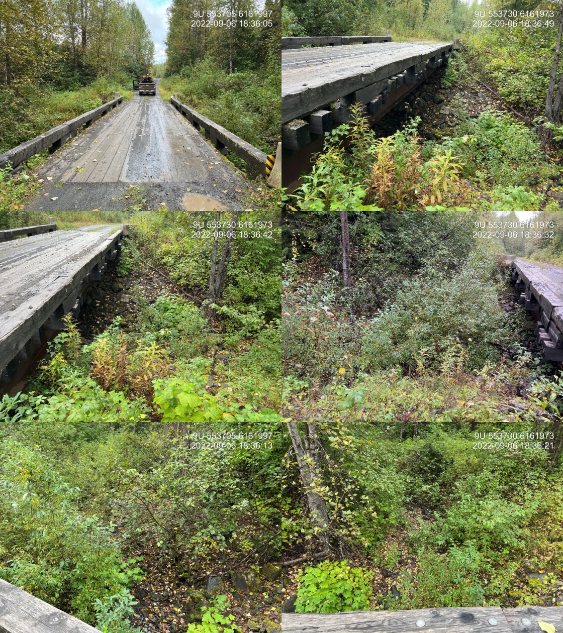
|
|||
| Comments: Bridge. Stream bed is dry at time of assessment. 18:33 |
| Location and Stream Data |
|
Crossing Characteristics | – |
|---|---|---|---|
| Date | 2022-09-07 | Crossing Sub Type | Bridge |
| PSCIS ID | 198233 | Diameter (m) | 4 |
| External ID | 8302779 | Length (m) | 3 |
| Crew | MW | Embedded | – |
| UTM Zone | 9 | Depth Embedded (m) | – |
| Easting | 564361.9 | Resemble Channel | – |
| Northing | 6167113 | Backwatered | – |
| Stream | Trib to Cullon Creek | Percent Backwatered | – |
| Road | Cullon Main | Fill Depth (m) | – |
| Road Tenure | MoF 7871 | Outlet Drop (m) | – |
| Channel Width (m) | – | Outlet Pool Depth (m) | – |
| Stream Slope (%) | – | Inlet Drop | – |
| Beaver Activity | No | Slope (%) | – |
| Habitat Value | – | Valley Fill | – |
| Final score | 0 | Barrier Result | Passable |
| Fix type | – | Fix Span / Diameter | – |
Photos: PSCIS ID 198233. From top left clockwise: Road/Site Card, Barrel, Outlet, Downstream, Upstream, Inlet.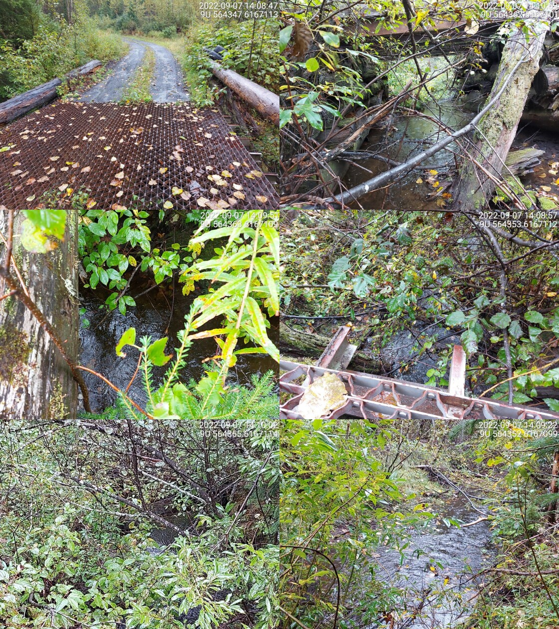
|
|||
| Comments: Bridge is a little rotten but in ok shape. 14:11 |
| Location and Stream Data |
|
Crossing Characteristics | – |
|---|---|---|---|
| Date | 2022-09-07 | Crossing Sub Type | Bridge |
| PSCIS ID | 198234 | Diameter (m) | 3.5 |
| External ID | 8301892 | Length (m) | 6 |
| Crew | MW | Embedded | – |
| UTM Zone | 9 | Depth Embedded (m) | – |
| Easting | 569230.1 | Resemble Channel | – |
| Northing | 6166554 | Backwatered | – |
| Stream | Trib to Carrigan Creek | Percent Backwatered | – |
| Road | Skeena Carrigan FSR | Fill Depth (m) | – |
| Road Tenure | MoF 7871 | Outlet Drop (m) | – |
| Channel Width (m) | – | Outlet Pool Depth (m) | – |
| Stream Slope (%) | – | Inlet Drop | – |
| Beaver Activity | No | Slope (%) | – |
| Habitat Value | – | Valley Fill | – |
| Final score | 0 | Barrier Result | Passable |
| Fix type | – | Fix Span / Diameter | – |
Photos: PSCIS ID 198234. From top left clockwise: Road/Site Card, Barrel, Outlet, Downstream, Upstream, Inlet.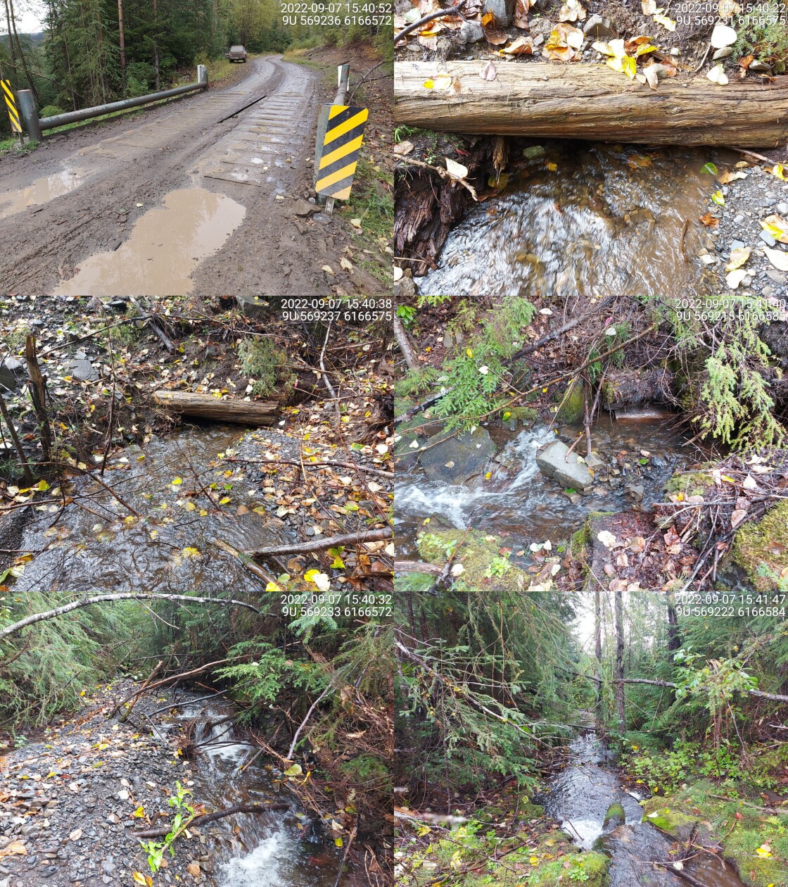
|
|||
| Comments: Bridge with very deep fill. Approx. 10cm between water and bottom of bridge. 15:38 |
| Location and Stream Data |
|
Crossing Characteristics | – |
|---|---|---|---|
| Date | 2022-09-09 | Crossing Sub Type | Bridge |
| PSCIS ID | 198235 | Diameter (m) | 14 |
| External ID | 8302212 | Length (m) | 5 |
| Crew | AI | Embedded | – |
| UTM Zone | 9 | Depth Embedded (m) | – |
| Easting | 550746.8 | Resemble Channel | – |
| Northing | 6141256 | Backwatered | – |
| Stream | Kitwanga River | Percent Backwatered | – |
| Road | Spur | Fill Depth (m) | – |
| Road Tenure | Kispiox River Timber R11351 | Outlet Drop (m) | – |
| Channel Width (m) | – | Outlet Pool Depth (m) | – |
| Stream Slope (%) | – | Inlet Drop | – |
| Beaver Activity | No | Slope (%) | – |
| Habitat Value | – | Valley Fill | – |
| Final score | 0 | Barrier Result | Passable |
| Fix type | – | Fix Span / Diameter | – |
Photos: PSCIS ID 198235. From top left clockwise: Road/Site Card, Barrel, Outlet, Downstream, Upstream, Inlet.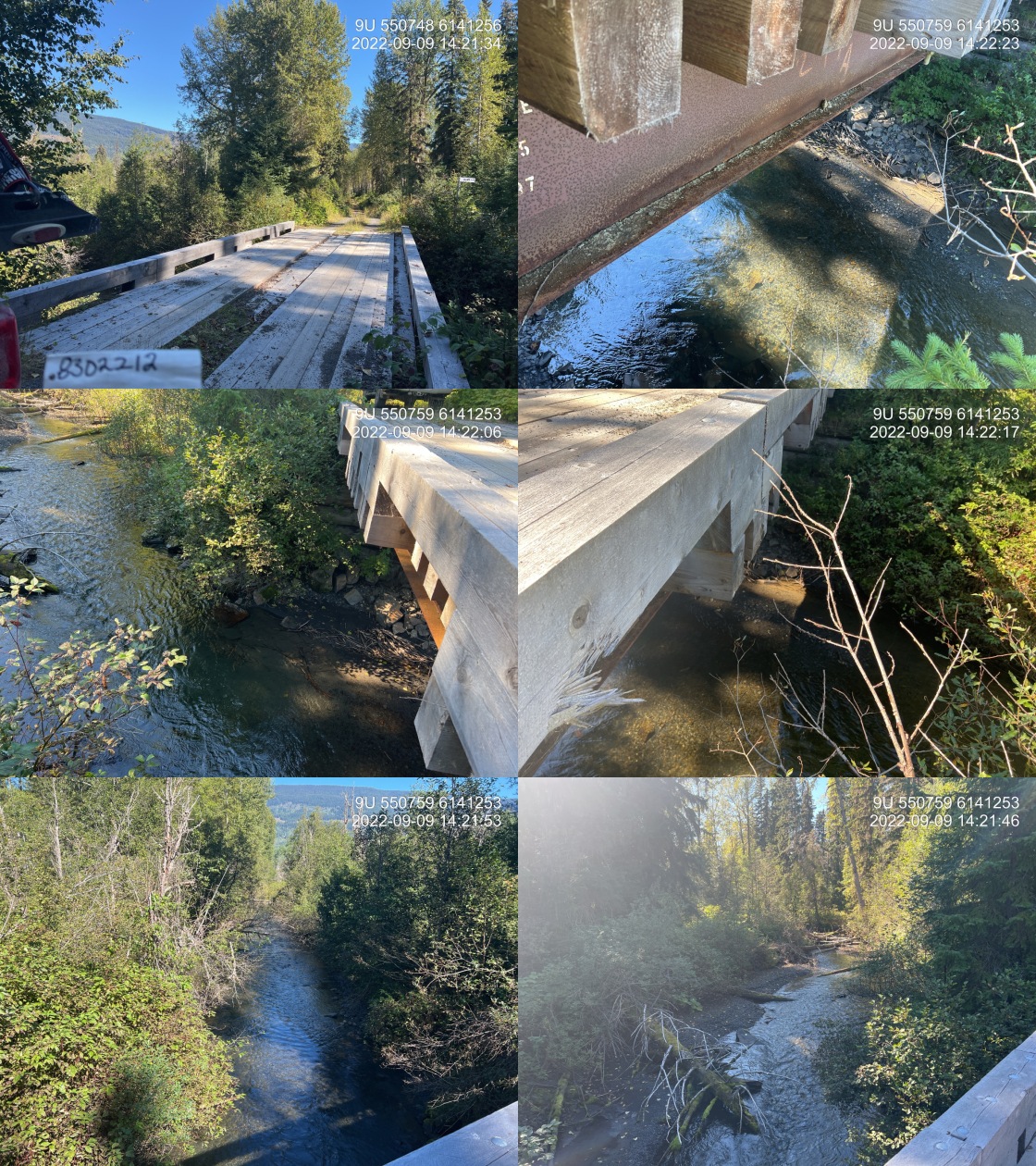
|
|||
| Comments: Bridge, beautiful river. 14:18 |
| Location and Stream Data |
|
Crossing Characteristics | – |
|---|---|---|---|
| Date | 2022-09-09 | Crossing Sub Type | Round Culvert |
| PSCIS ID | 198236 | Diameter (m) | 0.85 |
| External ID | 8301994 | Length (m) | 10 |
| Crew | AI JO | Embedded | No |
| UTM Zone | 9 | Depth Embedded (m) | – |
| Easting | 550300 | Resemble Channel | No |
| Northing | 6140708 | Backwatered | No |
| Stream | Tributary to Kitwanga River | Percent Backwatered | – |
| Road | Kitwancool Branch 2 FSR | Fill Depth (m) | 0.45 |
| Road Tenure | MoF 8687 | Outlet Drop (m) | 0.24 |
| Channel Width (m) | 2.3 | Outlet Pool Depth (m) | 0.22 |
| Stream Slope (%) | 1 | Inlet Drop | No |
| Beaver Activity | No | Slope (%) | 3.5 |
| Habitat Value | High | Valley Fill | Deep Fill |
| Final score | 31 | Barrier Result | Barrier |
| Fix type | Replace with New Open Bottom Structure | Fix Span / Diameter | 10 |
Photos: PSCIS ID 198236. From top left clockwise: Road/Site Card, Barrel, Outlet, Downstream, Upstream, Inlet.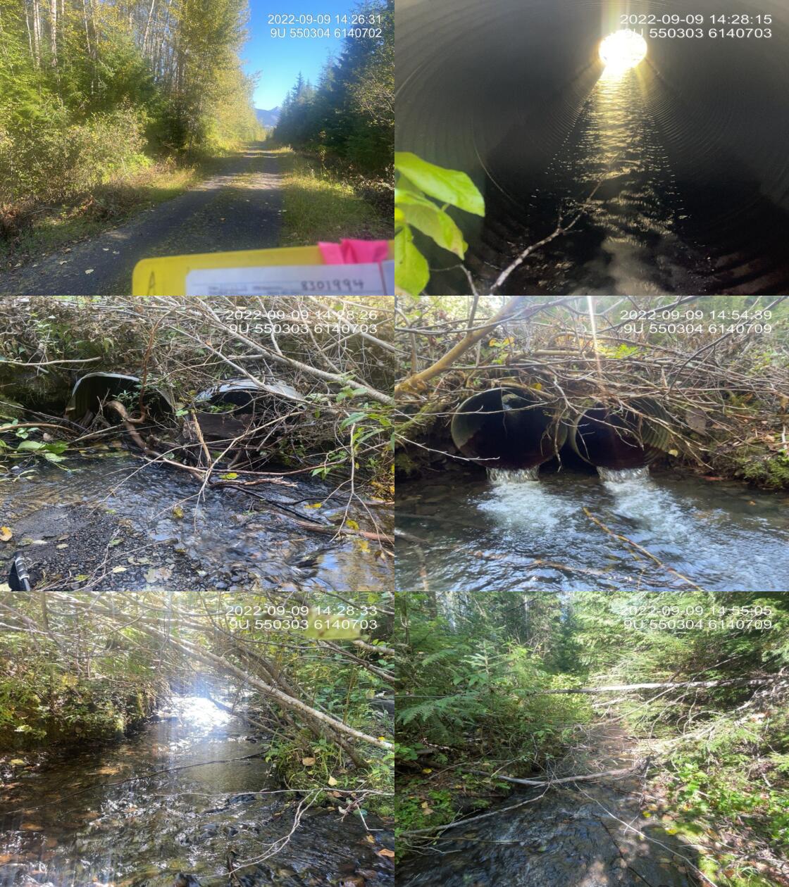
|
|||
| Comments: 2 culverts side by side, lots of beaver activity in the area. 14:23:18 |
| Location and Stream Data |
|
Crossing Characteristics | – |
|---|---|---|---|
| Date | 2022-09-13 | Crossing Sub Type | Bridge |
| PSCIS ID | 198237 | Diameter (m) | 9.8 |
| External ID | 4600909 | Length (m) | 5 |
| Crew | TP | Embedded | – |
| UTM Zone | 9 | Depth Embedded (m) | – |
| Easting | 598446.8 | Resemble Channel | – |
| Northing | 6071181 | Backwatered | – |
| Stream | Tributary to Zymoetz River | Percent Backwatered | – |
| Road | McDonnell Lake FSR | Fill Depth (m) | – |
| Road Tenure | MoF 7552 | Outlet Drop (m) | – |
| Channel Width (m) | – | Outlet Pool Depth (m) | – |
| Stream Slope (%) | – | Inlet Drop | – |
| Beaver Activity | No | Slope (%) | – |
| Habitat Value | – | Valley Fill | – |
| Final score | 0 | Barrier Result | Passable |
| Fix type | – | Fix Span / Diameter | – |
Photos: PSCIS ID 198237. From top left clockwise: Road/Site Card, Barrel, Outlet, Downstream, Upstream, Inlet.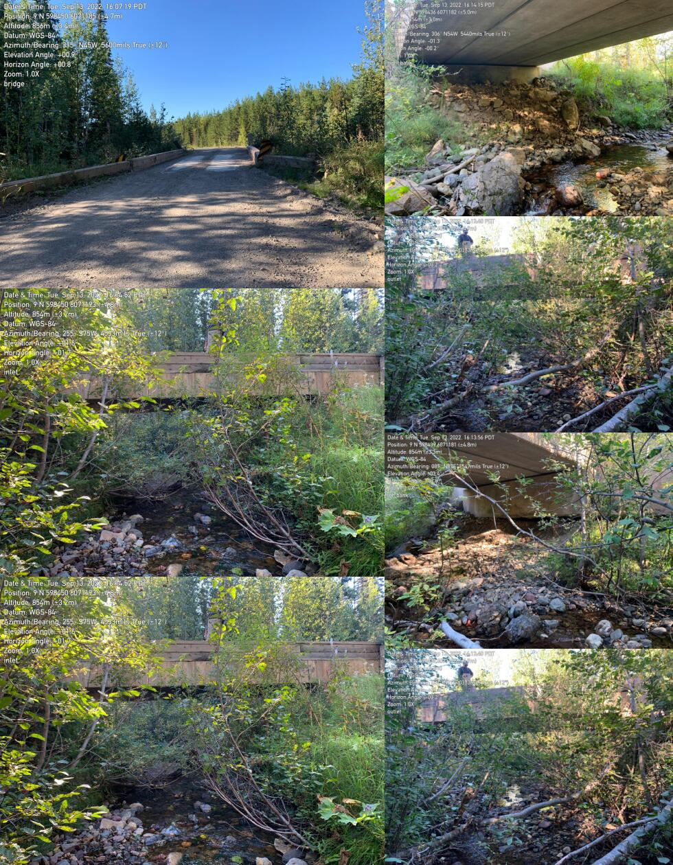
|
|||
| Comments: Bridge. 16:06:47 |
| Location and Stream Data |
|
Crossing Characteristics | – |
|---|---|---|---|
| Date | 2022-09-13 | Crossing Sub Type | Bridge |
| PSCIS ID | 198238 | Diameter (m) | 10 |
| External ID | 4600907 | Length (m) | 5 |
| Crew | TP | Embedded | – |
| UTM Zone | 9 | Depth Embedded (m) | – |
| Easting | 604915.3 | Resemble Channel | – |
| Northing | 6070603 | Backwatered | – |
| Stream | Henderson Creek | Percent Backwatered | – |
| Road | McDonnell Lake FSR | Fill Depth (m) | – |
| Road Tenure | MoF 7552 | Outlet Drop (m) | – |
| Channel Width (m) | – | Outlet Pool Depth (m) | – |
| Stream Slope (%) | – | Inlet Drop | – |
| Beaver Activity | No | Slope (%) | – |
| Habitat Value | – | Valley Fill | – |
| Final score | 0 | Barrier Result | Passable |
| Fix type | – | Fix Span / Diameter | – |
Photos: PSCIS ID 198238. From top left clockwise: Road/Site Card, Barrel, Outlet, Downstream, Upstream, Inlet.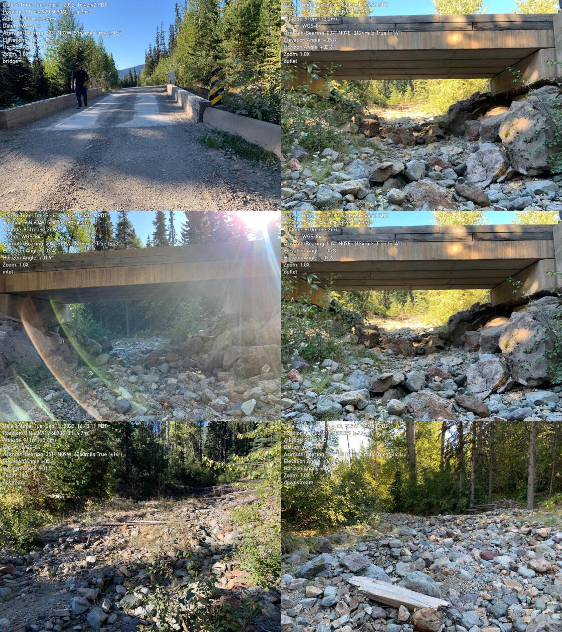
|
|||
| Comments: Bridge. 16:41:36 |
| Location and Stream Data |
|
Crossing Characteristics | – |
|---|---|---|---|
| Date | 2022-09-13 | Crossing Sub Type | Bridge |
| PSCIS ID | 198239 | Diameter (m) | 6 |
| External ID | 4742005 | Length (m) | 4 |
| Crew | TP | Embedded | – |
| UTM Zone | 9 | Depth Embedded (m) | – |
| Easting | 605308.4 | Resemble Channel | – |
| Northing | 6069773 | Backwatered | – |
| Stream | White Swan Creek | Percent Backwatered | – |
| Road | McDonnell Lake FSR | Fill Depth (m) | – |
| Road Tenure | MoF 7552 | Outlet Drop (m) | – |
| Channel Width (m) | – | Outlet Pool Depth (m) | – |
| Stream Slope (%) | – | Inlet Drop | – |
| Beaver Activity | No | Slope (%) | – |
| Habitat Value | – | Valley Fill | – |
| Final score | 0 | Barrier Result | Passable |
| Fix type | – | Fix Span / Diameter | – |
Photos: PSCIS ID 198239. From top left clockwise: Road/Site Card, Barrel, Outlet, Downstream, Upstream, Inlet.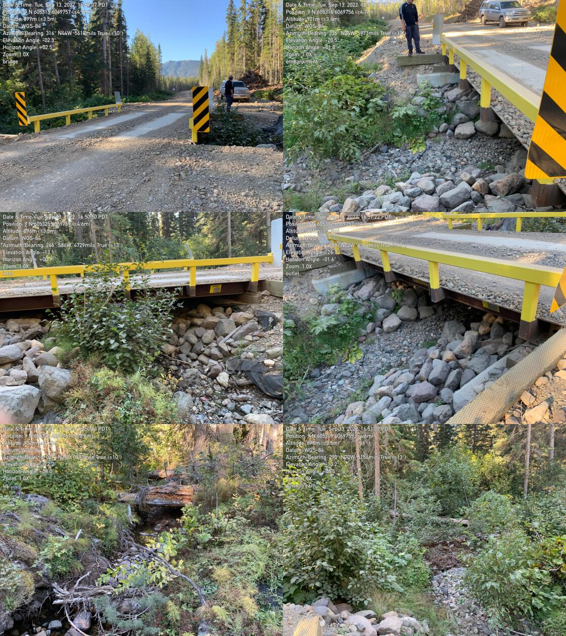
|
|||
| Comments: Bridge. 16:51:49 |
| Location and Stream Data |
|
Crossing Characteristics | – |
|---|---|---|---|
| Date | 2022-09-09 | Crossing Sub Type | Round Culvert |
| PSCIS ID | 198240 | Diameter (m) | 3.8 |
| External ID | 8300090 | Length (m) | 25 |
| Crew | AI JO | Embedded | Yes |
| UTM Zone | 9 | Depth Embedded (m) | 2.16 |
| Easting | 558928.3 | Resemble Channel | Yes |
| Northing | 6126836 | Backwatered | No |
| Stream | Trib to Kitwanga river | Percent Backwatered | – |
| Road | Highway 37 | Fill Depth (m) | 2 |
| Road Tenure | MoTi Highway | Outlet Drop (m) | 0 |
| Channel Width (m) | 2.6 | Outlet Pool Depth (m) | 0 |
| Stream Slope (%) | 2 | Inlet Drop | No |
| Beaver Activity | Yes | Slope (%) | 2 |
| Habitat Value | High | Valley Fill | Deep Fill |
| Final score | 8 | Barrier Result | Passable |
| Fix type | – | Fix Span / Diameter | – |
Photos: PSCIS ID 198240. From top left clockwise: Road/Site Card, Barrel, Outlet, Downstream, Upstream, Inlet.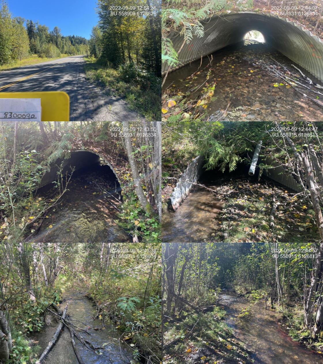
|
|||
| Comments: Culvert embedded resembles stream. UTM corrected as is approximately 100m down road from modelled location. 12:25 |