Dale Creek - 198215 - Appendix
Site Location
PSCIS crossing 198215 is located 0.1km
upstream from the confluence with the Kispiox River, on
Dale Creek. The site is located on Kispiox Westside Rd (also known as Date Creek FSR), just outside the Gitxsan village of Kispiox. This crossing is the responsibility of the Ministry of Transportation and Infrastructure (chris_culvert_id = 1524775). The Dale Creek watershed provides domestic water to the community of Kispiox (Rabnett, Gottesfeld, and Hall 2003).
Background
At crossing 198215, Dale Creek is a third order stream with an upstream watershed area of approximately 8.8km2. The elevation of the watershed ranges from a maximum of 1173m to 359m near the crossing (Table 5.7). At the time of reporting, there was no fisheries information available for the area upstream of crossing 198215 (MoE 2020b; Norris 2022).
Two dams have been mapped as present on Dale Creek approximately 620m and 800m upstream of Kispiox Westside Rd with dam_ids within bcfishpass of 166c070f-a324-40fb-addb-886dd23a9fc1 and 0de8a19d-eb93-4102-b124-8738f27e9e13 respectively (Canadian Wildlife Federation 2023; Norris 2021d). These GIS points may have been historical mapped in relation to drinking water diversion, storage and treatment infrastructure.
The culverts and stream were initially assessed on September 9, 2022 and rated as moderate priority for proceeding to design for replacement, with a recommendation to conduct electrofishing to further inform prioritization. The site was revisited September 21, 2023 and electrofishing was conducted upstream and downstream of the crossing to provide insight into fish community composition and density, with results included in this report.
fpr::fpr_table_wshd_sum(site_id = my_site) %>%
  fpr::fpr_kable(caption_text = paste0('Summary of derived upstream watershed statistics for PSCIS crossing ', my_site, '.'),
           footnote_text = 'Elev P60 = Elevation at which 60% of the watershed area is above',
scroll = F)| Site | Area Km | Elev Site | Elev Min | Elev Max | Elev Median | Elev P60 | Aspect |
|---|---|---|---|---|---|---|---|
| 198215 | 8.8 | 250 | 359 | 1173 | 802 | 689 | E |
| * Elev P60 = Elevation at which 60% of the watershed area is above |
A summary of habitat modelling outputs is presented in Table 5.8. A map of the watershed is provided in map attachment 093M.106.
| Habitat | Potential | Remediation Gain | Remediation Gain (%) |
|---|---|---|---|
| ST Network (km) | 0.8 | 0.6 | 75 |
| ST Lake Reservoir (ha) | – | 0.0 | – |
| ST Wetland (ha) | – | 0.0 | – |
| ST Slopeclass03 Waterbodies (km) | 0.0 | 0.0 | – |
| ST Slopeclass03 (km) | 0.0 | 0.0 | – |
| ST Slopeclass05 (km) | 0.0 | 0.0 | – |
| ST Slopeclass08 (km) | 0.6 | 0.6 | 100 |
| ST Spawning (km) | 0.0 | 0.0 | – |
| ST Rearing (km) | 0.0 | 0.0 | – |
| CH Spawning (km) | 0.0 | 0.0 | – |
| CH Rearing (km) | 0.0 | 0.0 | – |
| CO Spawning (km) | 0.0 | 0.0 | – |
| CO Rearing (km) | 0.0 | 0.0 | – |
| CO Rearing (ha) | – | 0.0 | – |
| SK Spawning (km) | 0.0 | 0.0 | – |
| SK Rearing (km) | 0.0 | 0.0 | – |
| SK Rearing (ha) | – | 0.0 | – |
| * Model data is preliminary and subject to adjustments. |
5.1 Climate Change Risk Assessment
Preliminary climate change risk assessment data for the site is presented in Tables 5.9 - 5.10.
| Condition and Climate Risk | Rank | Priority | Rank |
|---|---|---|---|
| Erosion (scale 1 low - 5 high) | 1 | Traffic Volume 1 (low) 5 (medium) 10 (high) | 3 |
| Embankment fill issues 1 (low) 2 (medium) 3 (high) | 1 | Community Access - Scale - 1 (high - multiple road access) 5 (medium - some road access) 10 (low - one road access) | 3 |
| Blockage Issues 1 (0-30%) 2 (>30-75%) 3 (>75%) | 2 | Cost (scale: 1 high - 10 low) | 5 |
| Condition Rank = embankment + blockage + erosion | 4 | Constructibility (scale: 1 difficult -10 easy) | 5 |
| Likelihood Flood Event Affecting Culvert (scale 1 low - 5 high) | 1 | Environmental Impacts (scale: 1 high -10 low) | 7 |
| Consequence Flood Event Affecting Culvert (scale 1 low - 5 high) | 3 | Fish Bearing 10 (Yes) 0 (No) - see maps for fish points | 10 |
| Climate Change Flood Risk (likelihood x consequence) 1-6 (low) 6-12 (medium) 10-25 (high) | 3 | Priority Rank = traffic volume + community access + cost + constructability + fish bearing + environmental impacts | 33 |
| Vulnerability Rank = Condition Rank + Climate Rank | 7 | Overall Rank = Vulnerability Rank + Priority Rank | 40 |
| Category | Comments |
|---|---|
| Condition | Right pipe completely blocked. Structure appears near the end of life. Although ineffective, historic work done downstream to try to backwater the structure. |
| Climate | Large tributary so significant flood eventscould wash out the Date Creek FSR. |
| Priority | Some residences on this road so potentially joint MoTi and MoF management. Deep fill will make replacement difficult, costs high and blow out consequences significant. |
Stream Characteristics at Crossing
At the time of the survey in 2022, PSCIS crossing 198215 was un-embedded, non-backwatered and ranked as a barrier to upstream fish passage according to the provincial protocol (MoE 2011b) (Table 5.11). There were two culverts side by side, but one was not functioning and had debris blocking the outlet. There was low flow through the functioning culvert at the time of survey. The outlet drop was significant at 1.1m. Water temperature was 10\(^\circ\)C, pH was 8.3 and conductivity was 164uS/cm.
| Location and Stream Data |
|
Crossing Characteristics | – |
|---|---|---|---|
| Date | 2022-09-09 | Crossing Sub Type | Round Culvert |
| PSCIS ID | 198215 | Diameter (m) | 3.7 |
| External ID | – | Length (m) | 32 |
| Crew | AI JO | Embedded | No |
| UTM Zone | 9 | Depth Embedded (m) | – |
| Easting | 582153.7 | Resemble Channel | No |
| Northing | 6135026 | Backwatered | No |
| Stream | Dale Creek | Percent Backwatered | – |
| Road | Kispiox Westside Rd | Fill Depth (m) | 5.5 |
| Road Tenure | MoTi Local | Outlet Drop (m) | 1.1 |
| Channel Width (m) | 5.3 | Outlet Pool Depth (m) | 0.85 |
| Stream Slope (%) | 5.5 | Inlet Drop | No |
| Beaver Activity | No | Slope (%) | 4 |
| Habitat Value | High | Valley Fill | Deep Fill |
| Final score | 42 | Barrier Result | Barrier |
| Fix type | Replace with New Open Bottom Structure | Fix Span / Diameter | 20.5 |
Photos: From top left clockwise: Road/Site Card, Barrel, Outlet, Downstream, Upstream, Inlet.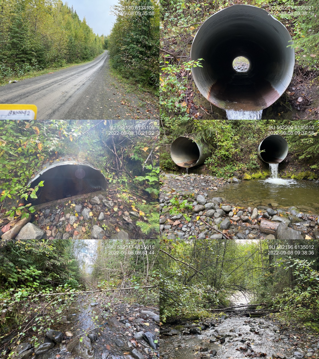
|
|||
| Comments: .75-.90 m lock block step located approximately 30 m down stream of culvert. Double pipe however right pipe is not functioning and is 50% blocked at the outlet. Both pipes are of same diameter (1.85m). 9:32 |
Stream Characteristics Downstream
The stream was surveyed downstream from crossing 198215 for 60m to the confluence with the Kispiox River (Figures 5.11 - 5.12). The average channel width was 5.3m, the average wetted width was 2.1m, and the average gradient was 11%.Total cover amount was rated as trace with boulders dominant. Cover was also present as large woody debris and overhanging vegetation.The dominant substrate was cobbles with gravels sub-dominant. This stretch of stream was steep with one lock block step approximately 30m downstream of the culvert that was approximately 1m in height, which could block upstream migration for non adult fish species. It is thought that the lock blocks were likely originally placed in this location to backwater the site, minimize the culvert outlet drop and facilitate upstream fish passage. The habitat was rated as medium value for salmonid rearing and spawning.
Stream Characteristics Upstream
The stream was surveyed upstream from crossing 198215 for 800m (Figures 5.13 - 5.16). The average channel width was 3.8m, the average wetted width was 2.3m, and the average gradient was 7%.Total cover amount was rated as moderate with large woody debris dominant. Cover was also present as small woody debris, boulders, deep pools, and overhanging vegetation.The dominant substrate was cobbles with boulders sub-dominant. Surveyors noted numerous cascades to approximately 1m in height with deep pools downstream and significant amounts of large woody debris. There were trace amount of gravels suitable for spawning. After the first 500m of the survey, it was noted that there were logs present perpendicular to the flow within the streambed at regular intervals that were potentially placed to capture substrate and provide complexity. The stream was surveyed to the mapped location of the first mapped dam at 800m upstream of the FSR. Although the dam was not present, there appeared to be some remnants of a historic structure in the form of logs (Figure 5.15). The habitat was rated as medium value as an important migration corridor containing spawning habitat suitable for coho and steelhead and having moderate rearing potential for both species.
Fish Sampling
As per recommendations from the 2022 survey, crossing 198215 was revisited on September 21, 2023 and electrofishing was conducted with results summarised in Tables 5.13 - 5.14 and Figure 5.10. A total of 42 fish were captured upstream, including cutthroat trout and rainbow trout, and 44 fish were captured downstream, including cutthroat trout, rainbow trout, and dolly varden (Figures 5.17 - 5.18). All fish captured with a fork length greater than 60mm were tagged with Passive Integrated Transponders (PIT tags) with data stored here.
Structure Remediation and Cost Estimate
Should restoration/maintenance activities proceed, replacement of PSCIS crossing 198215 with a bridge (20.5m span) is recommended. The cost of the work is estimated at $2,050,000 for a cost benefit of 0.4 linear m/$1000 and 1 m2/$1000 with the relatively high costs of the work predicted primarily related to the large amount of road fill present at the site and the subsequent significant excavation required to install the large replacement structure.
Conclusion
The BC freshwater atlas streamline indicates the stream gradient upstream of the FSR at 7.5% which coincides approximately with stream measurements. This value barely exceeds the 7.4% cutoff used in our reporting for modelling potential steelhead rearing habitat, so we elected to include an estimate of 0.8km of upstream habitat presetn suitable for steelhead rearing to a point where mapping indicates gradients increase to 11%. Areas surveyed were rated as medium value for salmonid rearing and spawning. Although there were no dam structures located at the two mapped locations upstream of the crossing, Dale Creek watershed does provide the community of Kispiox with domestic water so it is possible there could be a dam or other diversion structure present farther upstream. Nevertheless, there were no natural or man-made barriers observed within the 800m of habitat assessed upstream of Kispiox Westside Rd during the 2022 field surveys.
Following the 2022 survey, the site was ranked as moderate priority for proceeding to design for replacement, with a recommendation to conduct electrofishing to help further inform prioritization. As also noted above, the site was revisited in September of 2023 with electrofishing conducted upstream and downstream of the crossing. Cutthroat trout and rainbow trout were captured upstream of with cuthroat, rainbow and dolly varden captured downstream. All fish over 60mm in size were tagged with PIT tags so that their movement and health can be tracked over time to help inform prioritization and effectiveness monitoring should restoration activities advance.
tab_hab_summary %>%
  filter(Site  == my_site) %>%
  # select(-Site) %>%
  fpr::fpr_kable(caption_text = paste0('Summary of habitat details for PSCIS crossing ', my_site, '.'),
scroll = F) | Site | Location | Length Surveyed (m) | Channel Width (m) | Wetted Width (m) | Pool Depth (m) | Gradient (%) | Total Cover | Habitat Value |
|---|---|---|---|---|---|---|---|---|
| 198215 | Downstream | 60 | 5.3 | 2.1 | 0.8 | 11 | trace | medium |
| 198215 | Upstream | 800 | 3.8 | 2.3 | 0.5 | 7 | moderate | medium |
| site | passes | ef_length_m | ef_width_m | area_m2 | enclosure |
|---|---|---|---|---|---|
| 198215_ds_ef1 | 1 | 5 | 5.10 | 25.5 | Open |
| 198215_ds_ef2 | 1 | 3 | 4.10 | 12.3 | Open |
| 198215_ds_ef3 | 1 | 15 | 2.03 | 30.4 | Open |
| 198215_us_ef1 | 1 | 13 | 2.30 | 29.9 | Open |
| 198215_us_ef2 | 1 | 10 | 1.53 | 15.3 | Open |
| 198215_us_ef3 | 1 | 12 | 2.00 | 24.0 | Open |
| local_name | species_code | life_stage | catch | density_100m2 | nfc_pass |
|---|---|---|---|---|---|
| 198215_ds_ef1 | CT | fry | 5 | 19.6 | FALSE |
| 198215_ds_ef1 | CT | parr | 7 | 27.5 | FALSE |
| 198215_ds_ef1 | CT | juvenile | 5 | 19.6 | FALSE |
| 198215_ds_ef1 | CT | adult | 1 | 3.9 | FALSE |
| 198215_ds_ef1 | RB | fry | 2 | 7.8 | FALSE |
| 198215_ds_ef1 | RB | parr | 3 | 11.8 | FALSE |
| 198215_ds_ef2 | CT | fry | 5 | 40.7 | FALSE |
| 198215_ds_ef2 | DV | parr | 1 | 8.1 | FALSE |
| 198215_ds_ef2 | RB | parr | 1 | 8.1 | FALSE |
| 198215_ds_ef3 | CT | fry | 11 | 36.2 | FALSE |
| 198215_ds_ef3 | DV | fry | 1 | 3.3 | FALSE |
| 198215_ds_ef3 | RB | fry | 2 | 6.6 | FALSE |
| 198215_us_ef1 | CT | fry | 6 | 20.1 | FALSE |
| 198215_us_ef1 | CT | parr | 1 | 3.3 | FALSE |
| 198215_us_ef1 | RB | fry | 1 | 3.3 | FALSE |
| 198215_us_ef1 | RB | parr | 4 | 13.4 | FALSE |
| 198215_us_ef2 | CT | fry | 9 | 58.8 | FALSE |
| 198215_us_ef2 | CT | parr | 3 | 19.6 | FALSE |
| 198215_us_ef3 | CT | fry | 14 | 58.3 | FALSE |
| 198215_us_ef3 | RB | fry | 1 | 4.2 | FALSE |
| 198215_us_ef3 | RB | parr | 3 | 12.5 | FALSE |
|
* nfc_pass FALSE means fish were captured in final pass indicating more fish of this species/lifestage may have remained in site. Mark-recaptured required to reduce uncertainties. |
my_caption <- paste0('Densites of fish (fish/100m2) captured upstream and downstream of PSCIS crossing ', my_site, '.')

fpr_plot_fish_box(dat = fish_abund_2023, sit = my_site) 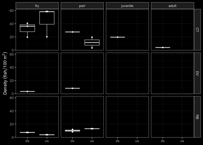
Figure 5.10: Densites of fish (fish/100m2) captured upstream and downstream of PSCIS crossing 198215.
my_photo1 = fpr::fpr_photo_pull_by_str(str_to_pull = '_d1_')

my_caption1 = paste0('Typical habitat downstream of PSCIS crossing ', my_site, '.')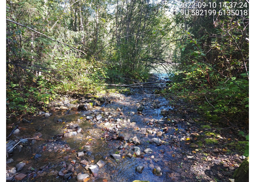
Figure 5.11: Typical habitat downstream of PSCIS crossing 198215.
my_photo2 = fpr::fpr_photo_pull_by_str(str_to_pull = '_d2_')

my_caption2 = paste0('Lock block step downstream of PSCIS crossing ', my_site, '.')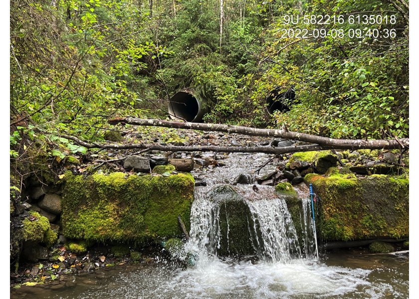
Figure 5.12: Lock block step downstream of PSCIS crossing 198215.
my_caption <- paste0('Left: ', my_caption1, ' Right: ', my_caption2)

knitr::include_graphics(my_photo1)
knitr::include_graphics("fig/pixel.png")
knitr::include_graphics(my_photo2)
my_photo1 = fpr::fpr_photo_pull_by_str(str_to_pull = '_u1_')
my_caption1 = paste0('Typical habitat upstream of PSCIS crossing ', my_site, '.')
Figure 5.13: Typical habitat upstream of PSCIS crossing 198215.
my_photo2 = fpr::fpr_photo_pull_by_str(str_to_pull = '_u2_')

my_caption2 = paste0('Typical habitat upstream of PSCIS crossing ', my_site, '.')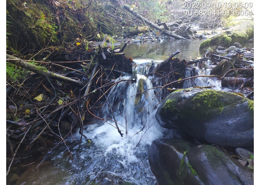
Figure 5.14: Typical habitat upstream of PSCIS crossing 198215.
my_caption <- paste0('Left: ', my_caption1, ' Right: ', my_caption2)

knitr::include_graphics(my_photo1)
knitr::include_graphics("fig/pixel.png")
knitr::include_graphics(my_photo2)
my_photo1 = fpr::fpr_photo_pull_by_str(str_to_pull = '_u3_')
my_caption1 = paste0('Location of old historic dam, upstream of PSCIS crossing ', my_site, '.')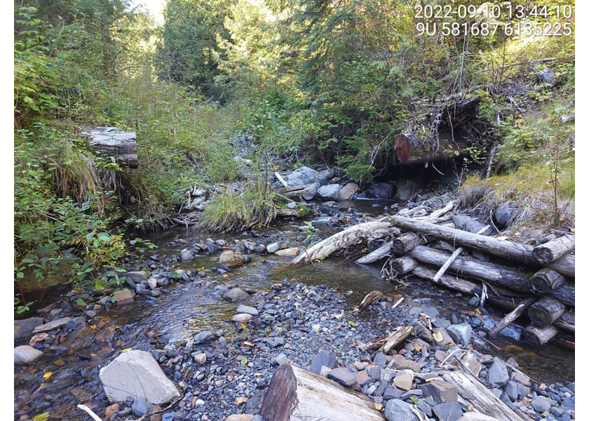
Figure 5.15: Location of old historic dam, upstream of PSCIS crossing 198215.
my_photo2 = fpr::fpr_photo_pull_by_str(str_to_pull = '_u4_')

my_caption2 = paste0('Typical habitat upstream of PSCIS crossing ', my_site, '.')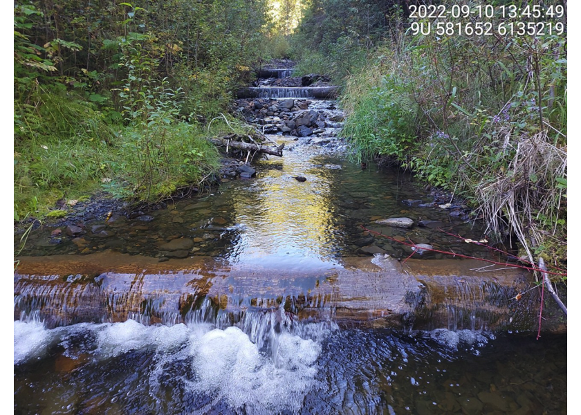
Figure 5.16: Typical habitat upstream of PSCIS crossing 198215.
my_caption <- paste0('Left: ', my_caption1, ' Right: ', my_caption2)

knitr::include_graphics(my_photo1)
knitr::include_graphics("fig/pixel.png")
knitr::include_graphics(my_photo2)
my_photo1 = fpr::fpr_photo_pull_by_str(site = my_site, dir_photos = "data/photos/", str_to_pull = '_ct_us')
my_caption1 = paste0('Cutthroat trout captured upstream of PSCIS crossing ', my_site, '.')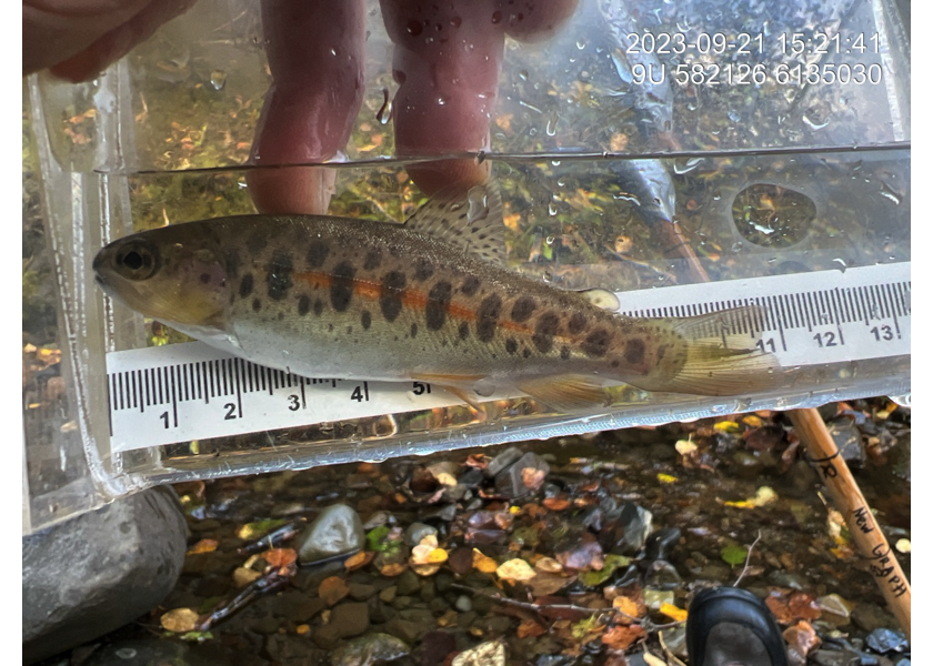
Figure 5.17: Cutthroat trout captured upstream of PSCIS crossing 198215.
my_photo2 = fpr::fpr_photo_pull_by_str(site = my_site, dir_photos = "data/photos/", str_to_pull = '_rb_us')

my_caption2 = paste0('Rainbow trout captured upstream of PSCIS crossing ', my_site, '.')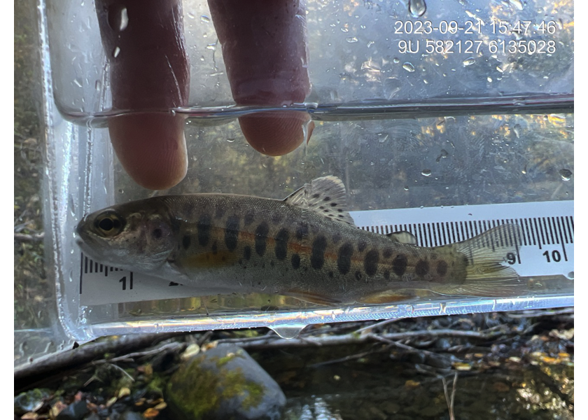
Figure 5.18: Rainbow trout captured upstream of PSCIS crossing 198215.
my_caption <- paste0('Left: ', my_caption1, ' Right: ', my_caption2)

knitr::include_graphics(my_photo1)
knitr::include_graphics("fig/pixel.png")
knitr::include_graphics(my_photo2)