Sterritt creek - 198225 - Appendix
Site Location
PSCIS crossing 198225 is located on Sterritt creek. This site is located on Babine Slide FSR, approximately 1.1km upstream from the confluence with the Skeena River.
Background
At crossing 198225, Sterritt creek is a fourth order stream with a watershed area upstream of the crossing of approximately 14.4km2. The elevation of the watershed ranges from a maximum of 2296m to 470m near the crossing (Table 5.37). At the time of reporting, there was no fisheries information available for the areas upstream of crossing 198225.
The stream was initially assessed on September 23, 2022, with much of this memo drafted then including recommendations for follow up fish sampling. The site was revisited on September 21, 2024. Results from the 2023 site visit is also now included in this updated report.
fpr::fpr_table_wshd_sum(site_id = my_site) %>%
  fpr::fpr_kable(caption_text = paste0('Summary of derived upstream watershed statistics for PSCIS crossing ', my_site, '.'),
           footnote_text = 'Elev P60 = Elevation at which 60% of the watershed area is above',
scroll = F)| Site | Area Km | Elev Site | Elev Min | Elev Max | Elev Median | Elev P60 | Aspect |
|---|---|---|---|---|---|---|---|
| 198225 | 14.4 | 369 | 470 | 2296 | 1441 | 1334 | SW |
| * Elev P60 = Elevation at which 60% of the watershed area is above |
A summary of habitat modelling outputs is presented in Table 5.38. A map of the watershed is provided in map attachment 093M.111.
| Habitat | Potential | Remediation Gain | Remediation Gain (%) |
|---|---|---|---|
| ST Network (km) | 3.4 | 0.6 | 18 |
| ST Lake Reservoir (ha) | – | 0.0 | – |
| ST Wetland (ha) | – | 0.0 | – |
| ST Slopeclass03 Waterbodies (km) | 0.0 | 0.0 | – |
| ST Slopeclass03 (km) | 0.0 | 0.0 | – |
| ST Slopeclass05 (km) | 0.6 | 0.6 | 100 |
| ST Slopeclass08 (km) | 0.7 | 0.0 | 0 |
| ST Spawning (km) | 0.6 | 0.6 | 100 |
| ST Rearing (km) | 1.3 | 0.6 | 46 |
| CH Spawning (km) | 0.6 | 0.6 | 100 |
| CH Rearing (km) | 0.6 | 0.6 | 100 |
| CO Spawning (km) | 0.6 | 0.6 | 100 |
| CO Rearing (km) | 0.6 | 0.6 | 100 |
| CO Rearing (ha) | – | 0.0 | – |
| SK Spawning (km) | 0.0 | 0.0 | – |
| SK Rearing (km) | 0.0 | 0.0 | – |
| SK Rearing (ha) | – | 0.0 | – |
| * Model data is preliminary and subject to adjustments. |
Stream Characteristics at Crossing
At the time of the survey, PSCIS crossing 198225 was un-embedded, non-backwatered and ranked as a barrier to upstream fish passage according to the provincial protocol (MoE 2011b) (Table 5.39). There was high flow through the culvert at the time of survey. A deep outlet pool (2m) and a large outlet drop (2m) indicate that the culvert may be undersized. Water temperature was 8\(^\circ\)C, pH was 7.9 and conductivity was 46uS/cm.
| Location and Stream Data |
|
Crossing Characteristics | – |
|---|---|---|---|
| Date | 2022-09-23 | Crossing Sub Type | Round Culvert |
| PSCIS ID | 198225 | Diameter (m) | 2.4 |
| External ID | – | Length (m) | 30 |
| Crew | JO | Embedded | No |
| UTM Zone | 9 | Depth Embedded (m) | – |
| Easting | 584898.7 | Resemble Channel | No |
| Northing | 6152502 | Backwatered | No |
| Stream | Sterritt creek | Percent Backwatered | – |
| Road | Babine Slide FSR | Fill Depth (m) | 4 |
| Road Tenure | MoF 4841 | Outlet Drop (m) | 2 |
| Channel Width (m) | 3.7 | Outlet Pool Depth (m) | 2 |
| Stream Slope (%) | 4.5 | Inlet Drop | Yes |
| Beaver Activity | No | Slope (%) | 3.5 |
| Habitat Value | Low | Valley Fill | Deep Fill |
| Final score | 42 | Barrier Result | Barrier |
| Fix type | Replace with New Open Bottom Structure | Fix Span / Diameter | 15 |
Photos: From top left clockwise: Road/Site Card, Barrel, Outlet, Downstream, Upstream, Inlet.
|
|||
| Comments: Culvert is separating 10 meters in from upstream, top of culvert slumping in. 10:06 |
Stream Characteristics Downstream
The stream was surveyed downstream from crossing 198225 for 260m in 2022 (Figures 5.45 - 5.46). The average channel width was 7.5m, the average wetted width was 5.6m, and the average gradient was 5.6%.Total cover amount was rated as trace with large woody debris dominant. Cover was also present as small woody debris, boulders, and undercut banks.The dominant substrate was large rock/bedrock with cobbles sub-dominant. Large woody debris was noted as abundant creating deep pools and small cascade steps. The habitat was rated as medium value for salmonid rearing.
As noted above, the site was revisited in 2023 with intent to conduct electrofishing - however, before sampling was conducted surveyors observed a 2 - 3m high near vertical cascade flowing over bedrock into the small culvert outlet pool immediately below the FSR so it was decided to not proceed with electrofishing.
Stream Characteristics Upstream
The stream was surveyed upstream from crossing 198225 for 500m (Figures 5.47 - 5.50). Total cover amount was rated as abundant with large woody debris dominant. Cover was also present as small woody debris.The dominant substrate was cobbles with gravels sub-dominant.The average channel width was 12.2m, the average wetted width was 5.5m, and the average gradient was 4.4%. This stream has the potential to be fish bearing but the gradient is steep. The bank full depth is very high, with a measured average of 0.8m. There was an abundance of large woody debris that provided functionality to the stream habitat by diverting flow and providing cover. The habitat was rated as medium value as an important migration corridor containing suitable rearing habitat.
Conclusion
As field surveys in the summer of 2023 confirmed a natural barrier (2 - 3m high near vertical cascade flowing over bedrock) immediately adjacent to the outlet of the crossing, replacement of the culvert with a bridge would not facilitate upstream fish migration so is not recommended.
tab_hab_summary %>%
  filter(Site  == my_site) %>%
  # select(-Site) %>%
  fpr::fpr_kable(caption_text = paste0('Summary of habitat details for PSCIS crossing ', my_site, '.'),
scroll = F) | Site | Location | Length Surveyed (m) | Channel Width (m) | Wetted Width (m) | Pool Depth (m) | Gradient (%) | Total Cover | Habitat Value |
|---|---|---|---|---|---|---|---|---|
| 198225 | Downstream | 260 | 7.5 | 5.6 | 0.4 | 5.6 | trace | medium |
| 198225 | Upstream | 500 | 12.2 | 5.5 | 0.4 | 4.4 | abundant | medium |
my_photo1 = fpr::fpr_photo_pull_by_str(str_to_pull = '_d1_')

my_caption1 = paste0('Typical habitat downstream of PSCIS crossing ', my_site, '.')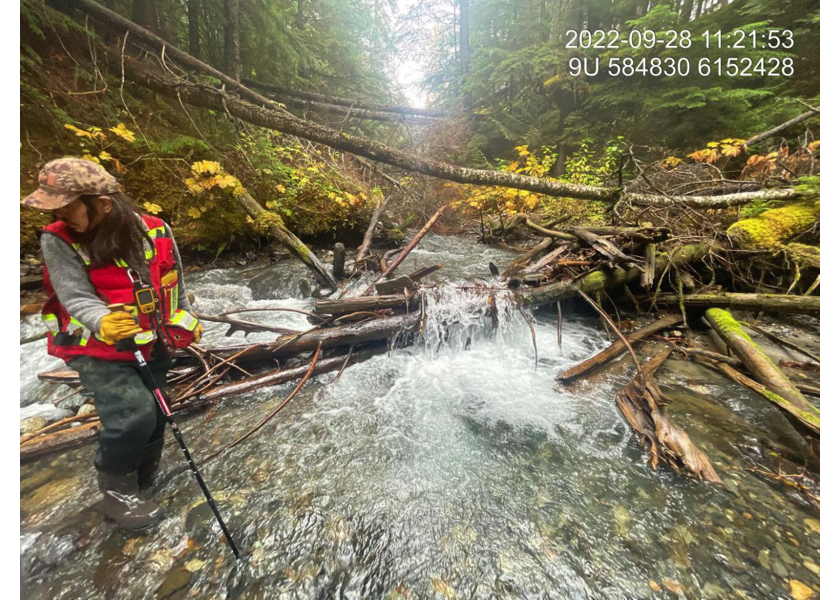
Figure 5.45: Typical habitat downstream of PSCIS crossing 198225.
my_photo2 = fpr::fpr_photo_pull_by_str(str_to_pull = '_d2_')

my_caption2 = paste0('Typical habitat downstream of PSCIS crossing ', my_site, '.')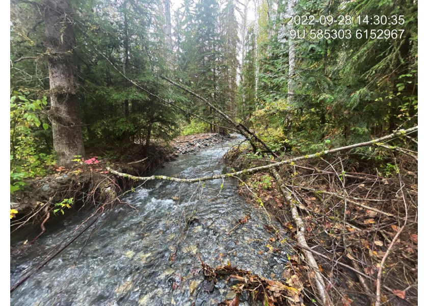
Figure 5.46: Typical habitat downstream of PSCIS crossing 198225.
my_caption <- paste0('Left: ', my_caption1, ' Right: ', my_caption2)

knitr::include_graphics(my_photo1)
knitr::include_graphics("fig/pixel.png")
knitr::include_graphics(my_photo2)
my_photo1 = fpr::fpr_photo_pull_by_str(str_to_pull = '_u1_')
my_caption1 = paste0('Typical habitat upstream of PSCIS crossing ', my_site, '.')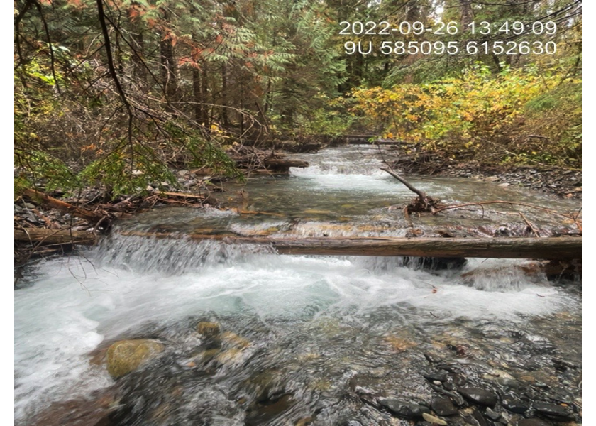
Figure 5.47: Typical habitat upstream of PSCIS crossing 198225.
my_photo2 = fpr::fpr_photo_pull_by_str(str_to_pull = '_u2_')

my_caption2 = paste0('Typical habitat upstream of PSCIS crossing ', my_site, '.')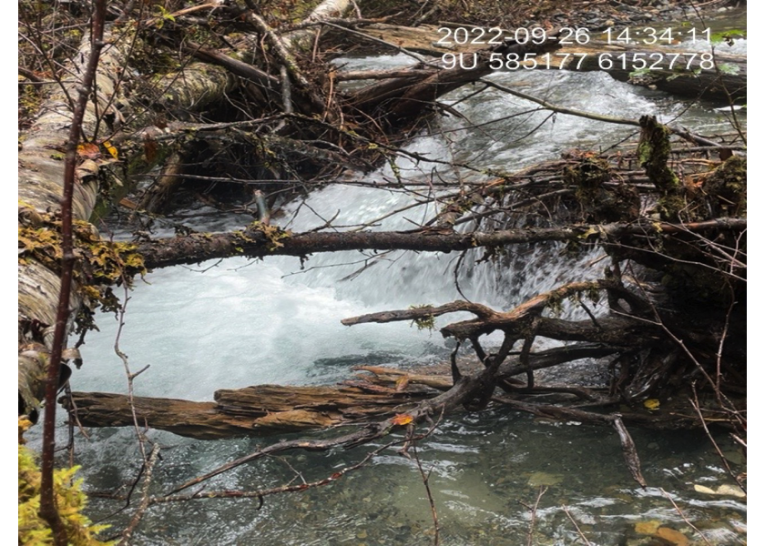
Figure 5.48: Typical habitat upstream of PSCIS crossing 198225.
my_caption <- paste0('Left: ', my_caption1, ' Right: ', my_caption2)

knitr::include_graphics(my_photo1)
knitr::include_graphics("fig/pixel.png")
knitr::include_graphics(my_photo2)
my_photo1 = fpr::fpr_photo_pull_by_str(str_to_pull = '_u3_')
my_caption1 = paste0('Typical habitat upstream of PSCIS crossing ', my_site, '.')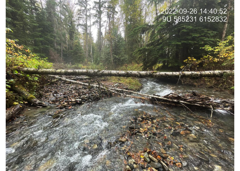
Figure 5.49: Typical habitat upstream of PSCIS crossing 198225.
my_photo2 = fpr::fpr_photo_pull_by_str(str_to_pull = '_u4_')

my_caption2 = paste0('Typical habitat upstream of PSCIS crossing ', my_site, '.')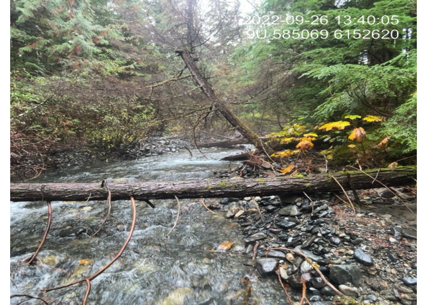
Figure 5.50: Typical habitat upstream of PSCIS crossing 198225.
my_caption <- paste0('Left: ', my_caption1, ' Right: ', my_caption2)

knitr::include_graphics(my_photo1)
knitr::include_graphics("fig/pixel.png")
knitr::include_graphics(my_photo2)